On 10 June the Volcano Alert Level and the Aviation Color Code for Sarigan was lowered to Unassigned because no further volcanic activity was noted since the submarine eruption from a vent S of the island on 29 May.
Studies reveal former summit removed and replaced by large crater due to the enigmatic May 2010 eruption
The last Bulletin report (BGVN 35:05) on South Sarigan Seamount was mistakenly catalogued under reports for Sarigan Island. In that report, a description of the 28-29 May 2010 eruption was discussed. Recently, Bulletin editors discovered that significant research has been completed concerning the South Sarigan Seamount's 2010 eruption. In this Bulletin report, we will discuss some of that research.
This new research concluded that the South Sarigan Seamount is "part of a volcanic centre comprised of multiple cone edifices…" (Green and others, 2013). The northerly cone of this volcanic center is believed to be the source of the 2010 eruption, which was observed visually when an eruption plume, was seen rising from the ocean (Embley and others, 2013). The plume rose ~12 km through the atmosphere and was tracked by satellite. The Washington Volcanic Ash Advisory Center (VAAC) put out a report to inform the aviation community of the plume (Embley and others, 2013).
The 2010 eruption has been defined seismo-acoustically, and studied with multibeam and in situ sampling. It lasted ~3 days beginning on 27 May 2010. This eruption dramatically altered the northerly cone's morphology, whose summit depth was initially ~184 m below sea level (Embley and others, 2013; Searcy, 2013). According to Embley and others (2013) the eruption led the formation of a breached crater, 350 m in diameter, and a substantial deposit on the W flank (figure 2). After the eruption, the crater floor dropped ~200 m beneath the pre-eruption summit (Embley and others, 2013).
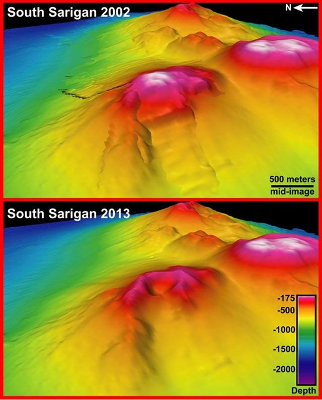 |
Figure 2. (Top and bottom, respectively) Bathymetry from before and after the eruption rendered as colored relief for the inferred vent for the 2010 South Sarigan eruptions. View is from the W (note N arrow, and length and depth scales). As labeled, the 2002 image (top) and 2013 image (bottom) show the loss of summit material and the development of a summit crater. Portions of the rim appear intact from the earlier upper edifice, but a cleft resides on the rim's W side. A zone of downslope deposits lies on this side of the edifice but is not identified on the image. The 2013 map was used to target dives with a JAMSTEC remotely operated vehicle in June 2013. This new information will help to better evaluate the hazard potential of submarine eruptions. Courtesy of NOAA PMEL. |
Much of the research on the South Sarigan Seamount was completed as the result of research vessels (RVs) cruises, and submarine remotely operated vehicles (ROVs) observing and documenting the eruptive deposits and morphologic changes at the vent. Multibeam data was also collected. The findings have been chronicled in several papers, some of which are discussed here (Tamura and others, 2013; Embley and others, 2013; and Green and others, 2013).
Green and others (2013), Searcy (2013) and Snellen and others (2011) used various combinations of hydroacoustic, infrasound, and seismic signals to study the pace and phases of the eruption from a geophysical perspective. Green and others (2013) found that the eruption occurred in three stages, separated by three-hour periods of quiescence. In brief, these stages included "(1) A 46 h period during which broadband impulsive hydroacoustic signals were generated . . . [a total of] 7602 identified events . . .(2) a 5-hour period of 10 Hz hydroacoustic tremor, interspersed with large-amplitude, broadband signals…(3) An hour-long period of transient broadband events [that] culminated in two large-amplitude hydroacoustic events and one broadband infrasound signal."
According to Green and others (2013), the first phase began at ~0241 UTC on 27 May 2010 when clustered hydroacoustic signals were detected by two hydroacoustic stations located on Wake Island and Queen Charlotte Islands. During this time, discolored water was also observed 8-11 km S of Sarigan Island. The second phase was detected at ~0330 UTC on 29 May with a near continuous tremor that lasted ~5 hours. The third phase, according to Green and others (2013) began at ~1137 UTC and at ~1209 UTC a distinctive tremor signal was detected. In addition to the seismic activity that occurred during the third phase, the ~12 km eruption plume was also generated.
Tamura and others (2013) noted a multibeam survey by R/V Melville conducted in early February 2013 over the unsurveyed main peak of South Sarigan Seamount volcanic center and over some of the previously surveyed peaks, enabling a comparison with the available older surveys. The older surveys consist of a 2002 survey by RV Ewing [EW0202] and a 2003 survey by RV Thompson [TN153] of the north peak where the 2010 eruption was believed to have taken place. Their comparisons show that downslope and W of the breach in the crater, a zone of positive depth changes of over 50 m occurs to ~2000 m depth on the volcano's flank. This is interpreted to be the deposit of material from the 2010 eruption together with part of the western flank that failed during the eruption. The volume of the downslope deposit is approximately twice as large as the amount of material lost from the summit. ROV dives on the volcano during 14-22 June 2013 showed that the northern wall of the crater appears to be "dominantly well-jointed andesite, with some interlayered basalt. No hydrothermal venting was observed in the crater, except weak shimmering water at the top of the crater wall."
Embley and others (2013) employed an ROV to retrieve downslope samples, including pumice believed to have been associated with the 2010 eruption. The pumice collected was found to be andesitic in composition. Lava blocks, believed to be from older lava flows, were also sampled. Both the andesitic pumice and lava blocks contained similar weight percentages of SiO2 and MgO, while the pumice had a slightly higher weight percentage of K2O. Embley and others (2013) concluded that due to the abundance of andesite found in samples from the crater and the W flank deposit, both the older and the 2010 eruption of the South Sarigan Seamount were dominantly andesite in composition.
According to Embley and others (2013): "The South Sarigan event is one of the first instances of an explosive, relatively deep, submarine eruption that breached the surface ocean and for which we have quantitative data for the size and extent of the cratering event and deposits to match with seismic and hydroacoustic monitoring information. Submarine craters the size of the one formed during the eruption of South Sarigan are relatively common on seamounts along intra-oceanic arcs... This event, and a deeper and much larger event at Havre Seamount in the Kermadec arc in 2012... underscores how little is known of the eruption history of most submarine arc volcanoes."
References: Embley, R.W., Y. Tamura, S.G. Merle, T. Sato, O. Ishizuka, W.W. Chadwick Jr., D.A. Wiens, P. Shore, and R.J. Stern. 2014. Eruption of South Sarigan Seamount, Northern Mariana Islands: Insights into hazards from submarine volcanic eruptions. Oceanography 27(2):24–31, http://dx.doi.org/10.5670/oceanog.2014.37.
Green, D. N., Evers, L. G., Fee, D., Matoza, R. S., Snellen, M., Smets, P., & Simons, D., 2013, Hydroacoustic, infrasonic and seismic monitoring of the submarine eruptive activity and sub-aerial plume generation at South Sarigan, May 2010. Journal of Volcanology and Geothermal Research, 257, 31-43.
Searcy, C. 2013. Seismicity associated with the May 2010 eruption of South Sarigan Seamount, northern Mariana Islands. Seismological Research Letters 84(6):1,055–1,061, http://dx.doi.org/10.1785/0220120168
Snellen, M., Evers, L., and Simons, D. G. (2011). "Modeling the long-range acoustic propagation for the May 2010 Sarigan volcano eruption," in Underwater Acoustics Measurements, edited by J. S. Papadakis (Kluwer, Kos, Greece), pp. 1361–1368
Tamura, Y.; Embley, R. W.; Nichols, A. R.; Ishizuka, O.; Merle, S. G.; Chadwick, B.; Stern, R. J.; Sato, T.; Wiens, D. A.; Shore, P., 2013, ROV Hyper-Dolphin Survey at the May 2010 Eruption Site on South Sarigan Seamount, Mariana Arc, Eos, Transactions of the American Geophysical Union [Paper presented at the 2013 Fall AGU Meeting], San Francisco, California, Abstract V31G-02
Information Contacts: Pacific Marine Environmental Laboratory, Ocean Environment Research Division, EOI Program, Hatfield Marine Science Center, 2115 S.E. OSU Dr., Newport, OR 97365.
On 10 June the Volcano Alert Level and the Aviation Color Code for Sarigan was lowered to Unassigned because no further volcanic activity was noted since the submarine eruption from a vent S of the island on 29 May.
On 27 May an observer from the Emergency Management Office (EMO) in Saipan photographed an area of discolored ocean water and possible light-colored floating material about 7 km S of Sarigan during an overflight. The area was about 1.6 km long, although the scale was difficult to discern from photographs. Two days later, the area of affected water was about twice the size of Sarigan Island. According to a news article, U.S. Fish and Wildlife evacuated 16 people, mostly scientists, to Saipan from a few area islands, including eight people from Sarigan.
On 30 May a plume of mostly water vapor was seen in satellite imagery rising to a possible altitude of 12.2 km (40,000 ft) a.s.l. and dissipating as it drifted S. The eruption was attributed to a 300-m-deep submarine vent on Sarigan's S flank, about 7 km from the island. Observers on Sarigan reported hearing a loud explosion from the S, and shortly thereafter received ashfall. The Volcano Alert Level was raised to Watch and the Aviation Color Code was raised to Orange. Both seismicity at a single nearby station on Sarigan and subaqueous activity declined after the plume emission. The next day the Volcano Alert Level was reduced to Advisory and the Aviation Color Code was reduced to Yellow.
Sources: Emergency Management Office of the Commonwealth of the Mariana Islands and United States Geological Survey Volcano Hazards Program; Saipan Tribune
Reports are organized chronologically and indexed below by Month/Year (Publication Volume:Number), and include a one-line summary. Click on the index link or scroll down to read the reports.
Sudden, short-lived, explosive eruption from submarine vent
According to a weekly USGS/CNMI Emergency Management Office (EMO) update on 4 June 2010, an explosive eruption from a submarine vent S of Sarigan Island occurred during 28-29 May 2010. The most energetic phase of the eruption, at 2147 on 29 May, lasted about 10 minutes based on seismic records from nearby Sarigan and Anatahan islands. The eruption sent an ash and gas cloud perhaps as high as 12.2 km altitude. Precursors included two moderate earthquakes and many smaller shocks; an earthquake of ~ M 4.8 accompanied the eruption. The plume drifted S, eventually passing over Guam (350 km SSW), but no fallout was reported there or on Saipan (165 km S).
Evidence of submarine volcanic activity was first observed late on 28 May during aerial observations by Juan Camacho, an EMO technician, who noted an elongate patch of discolored ocean water and possible light-colored floating debris about 8 km S of Sarigan Island. Alaska Volcano Observatory seismologists noted tremor on nearby seismic stations about the same time. Satellite image analysis by the National Weather Service in Guam indicated that the area of disturbance had grown significantly in size prior to the 29 May explosion. Within hours after the eruption, seismic activity began to decline, and after 31 May only a few scattered events were recorded.
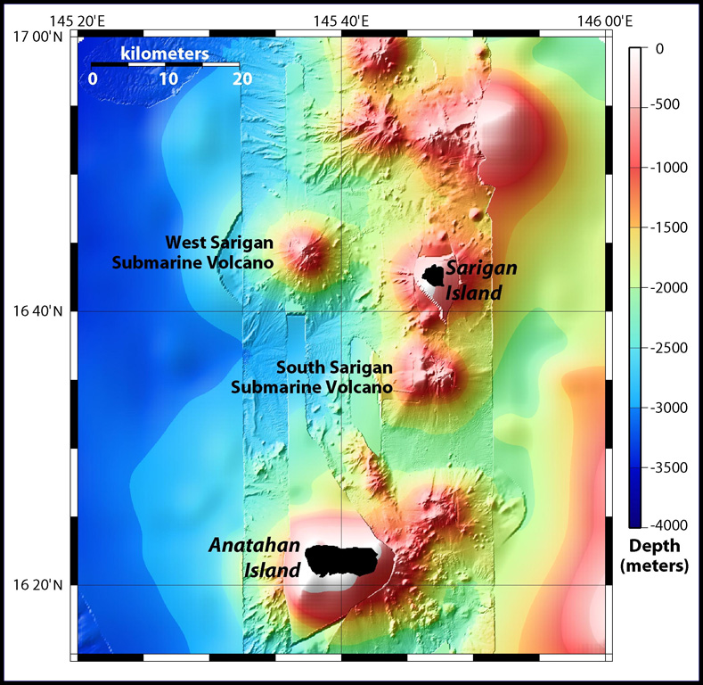
The vent's exact location and depth remained uncertain. According to the USGS, the most likely source is the summit area of the South Sarigan seamount ~ 11 km S of Sarigan Island (figure 1). The summit of the conical structure lies at depths less than ~ 500 m below the surface.
 |
Figure 1. Location map showing the volcanic islands of Sarigan and Anatahan, as well as the South and West Sarigan volcanic seamounts. Modified from Embley and Chadwick (2003). |
A U.S. Fish and Wildlife Service research crew camped on Sarigan Island reported many felt earthquakes prior to the eruption. An explosion that sounded like thunder accompanied the event. They also heard increasing ocean wave activity during the night. Subsequently, a minor ashfall occurred.
The NOAA West Coast and Alaska Tsunami Warning Center reported that a 5-cm-high tsunami related to this event may have been recorded on a tide gauge in Saipan. According to a news article in the Saipan Tribune, the U.S. Fish and Wildlife evacuated 16 people, mostly scientists, from nearby islands, including eight people from Sarigan.
The USGS reported no evidence of volcanism after the 29 May eruption. Seismicity recorded by the nearest seismometer, on Sarigan Island, had returned to background levels. Nothing unusual was observed in satellite data.
Reference. Embley, B., and Chadwick, B., 2003, MR1 sonar provides new view of sea floor around Mariana Islands: NOAA Ocean Explorer, Submarine Ring of Fire 2003, 17 February 2003 (http://oceanexplorer.noaa.gov/explorations/03fire/logs/feb17/feb17.html).
Information Contacts: Emergency Management Office of the Commonwealth of the Northern Mariana Islands (EMO-CNMI) and USGS Hawaii Volcano Observatory, PO Box 100007, Saipan, MP 96950, USA (URL: http://www.cnmihsem.gov.mp/ and https://volcanoes.usgs.gov/nmi/activity/); NOAA Ocean Explorer, National Oceanic and Atmospheric Administration, U.S. Department of Commerce (URL: http://oceanexplorer.noaa.gov/explorations/03fire/logs/feb17/feb17.html).
Studies reveal former summit removed and replaced by large crater due to the enigmatic May 2010 eruption
The last Bulletin report (BGVN 35:05) on South Sarigan Seamount was mistakenly catalogued under reports for Sarigan Island. In that report, a description of the 28-29 May 2010 eruption was discussed. Recently, Bulletin editors discovered that significant research has been completed concerning the South Sarigan Seamount's 2010 eruption. In this Bulletin report, we will discuss some of that research.
This new research concluded that the South Sarigan Seamount is "part of a volcanic centre comprised of multiple cone edifices…" (Green and others, 2013). The northerly cone of this volcanic center is believed to be the source of the 2010 eruption, which was observed visually when an eruption plume, was seen rising from the ocean (Embley and others, 2013). The plume rose ~12 km through the atmosphere and was tracked by satellite. The Washington Volcanic Ash Advisory Center (VAAC) put out a report to inform the aviation community of the plume (Embley and others, 2013).
The 2010 eruption has been defined seismo-acoustically, and studied with multibeam and in situ sampling. It lasted ~3 days beginning on 27 May 2010. This eruption dramatically altered the northerly cone's morphology, whose summit depth was initially ~184 m below sea level (Embley and others, 2013; Searcy, 2013). According to Embley and others (2013) the eruption led the formation of a breached crater, 350 m in diameter, and a substantial deposit on the W flank (figure 2). After the eruption, the crater floor dropped ~200 m beneath the pre-eruption summit (Embley and others, 2013).
|
Figure 2. (Top and bottom, respectively) Bathymetry from before and after the eruption rendered as colored relief for the inferred vent for the 2010 South Sarigan eruptions. View is from the W (note N arrow, and length and depth scales). As labeled, the 2002 image (top) and 2013 image (bottom) show the loss of summit material and the development of a summit crater. Portions of the rim appear intact from the earlier upper edifice, but a cleft resides on the rim's W side. A zone of downslope deposits lies on this side of the edifice but is not identified on the image. The 2013 map was used to target dives with a JAMSTEC remotely operated vehicle in June 2013. This new information will help to better evaluate the hazard potential of submarine eruptions. Courtesy of NOAA PMEL. |
Much of the research on the South Sarigan Seamount was completed as the result of research vessels (RVs) cruises, and submarine remotely operated vehicles (ROVs) observing and documenting the eruptive deposits and morphologic changes at the vent. Multibeam data was also collected. The findings have been chronicled in several papers, some of which are discussed here (Tamura and others, 2013; Embley and others, 2013; and Green and others, 2013).
Green and others (2013), Searcy (2013) and Snellen and others (2011) used various combinations of hydroacoustic, infrasound, and seismic signals to study the pace and phases of the eruption from a geophysical perspective. Green and others (2013) found that the eruption occurred in three stages, separated by three-hour periods of quiescence. In brief, these stages included "(1) A 46 h period during which broadband impulsive hydroacoustic signals were generated . . . [a total of] 7602 identified events . . .(2) a 5-hour period of 10 Hz hydroacoustic tremor, interspersed with large-amplitude, broadband signals…(3) An hour-long period of transient broadband events [that] culminated in two large-amplitude hydroacoustic events and one broadband infrasound signal."
According to Green and others (2013), the first phase began at ~0241 UTC on 27 May 2010 when clustered hydroacoustic signals were detected by two hydroacoustic stations located on Wake Island and Queen Charlotte Islands. During this time, discolored water was also observed 8-11 km S of Sarigan Island. The second phase was detected at ~0330 UTC on 29 May with a near continuous tremor that lasted ~5 hours. The third phase, according to Green and others (2013) began at ~1137 UTC and at ~1209 UTC a distinctive tremor signal was detected. In addition to the seismic activity that occurred during the third phase, the ~12 km eruption plume was also generated.
Tamura and others (2013) noted a multibeam survey by R/V Melville conducted in early February 2013 over the unsurveyed main peak of South Sarigan Seamount volcanic center and over some of the previously surveyed peaks, enabling a comparison with the available older surveys. The older surveys consist of a 2002 survey by RV Ewing [EW0202] and a 2003 survey by RV Thompson [TN153] of the north peak where the 2010 eruption was believed to have taken place. Their comparisons show that downslope and W of the breach in the crater, a zone of positive depth changes of over 50 m occurs to ~2000 m depth on the volcano's flank. This is interpreted to be the deposit of material from the 2010 eruption together with part of the western flank that failed during the eruption. The volume of the downslope deposit is approximately twice as large as the amount of material lost from the summit. ROV dives on the volcano during 14-22 June 2013 showed that the northern wall of the crater appears to be "dominantly well-jointed andesite, with some interlayered basalt. No hydrothermal venting was observed in the crater, except weak shimmering water at the top of the crater wall."
Embley and others (2013) employed an ROV to retrieve downslope samples, including pumice believed to have been associated with the 2010 eruption. The pumice collected was found to be andesitic in composition. Lava blocks, believed to be from older lava flows, were also sampled. Both the andesitic pumice and lava blocks contained similar weight percentages of SiO2 and MgO, while the pumice had a slightly higher weight percentage of K2O. Embley and others (2013) concluded that due to the abundance of andesite found in samples from the crater and the W flank deposit, both the older and the 2010 eruption of the South Sarigan Seamount were dominantly andesite in composition.
According to Embley and others (2013): "The South Sarigan event is one of the first instances of an explosive, relatively deep, submarine eruption that breached the surface ocean and for which we have quantitative data for the size and extent of the cratering event and deposits to match with seismic and hydroacoustic monitoring information. Submarine craters the size of the one formed during the eruption of South Sarigan are relatively common on seamounts along intra-oceanic arcs... This event, and a deeper and much larger event at Havre Seamount in the Kermadec arc in 2012... underscores how little is known of the eruption history of most submarine arc volcanoes."
References: Embley, R.W., Y. Tamura, S.G. Merle, T. Sato, O. Ishizuka, W.W. Chadwick Jr., D.A. Wiens, P. Shore, and R.J. Stern. 2014. Eruption of South Sarigan Seamount, Northern Mariana Islands: Insights into hazards from submarine volcanic eruptions. Oceanography 27(2):24–31, http://dx.doi.org/10.5670/oceanog.2014.37.
Green, D. N., Evers, L. G., Fee, D., Matoza, R. S., Snellen, M., Smets, P., & Simons, D., 2013, Hydroacoustic, infrasonic and seismic monitoring of the submarine eruptive activity and sub-aerial plume generation at South Sarigan, May 2010. Journal of Volcanology and Geothermal Research, 257, 31-43.
Searcy, C. 2013. Seismicity associated with the May 2010 eruption of South Sarigan Seamount, northern Mariana Islands. Seismological Research Letters 84(6):1,055–1,061, http://dx.doi.org/10.1785/0220120168
Snellen, M., Evers, L., and Simons, D. G. (2011). "Modeling the long-range acoustic propagation for the May 2010 Sarigan volcano eruption," in Underwater Acoustics Measurements, edited by J. S. Papadakis (Kluwer, Kos, Greece), pp. 1361–1368
Tamura, Y.; Embley, R. W.; Nichols, A. R.; Ishizuka, O.; Merle, S. G.; Chadwick, B.; Stern, R. J.; Sato, T.; Wiens, D. A.; Shore, P., 2013, ROV Hyper-Dolphin Survey at the May 2010 Eruption Site on South Sarigan Seamount, Mariana Arc, Eos, Transactions of the American Geophysical Union [Paper presented at the 2013 Fall AGU Meeting], San Francisco, California, Abstract V31G-02
Information Contacts: Pacific Marine Environmental Laboratory, Ocean Environment Research Division, EOI Program, Hatfield Marine Science Center, 2115 S.E. OSU Dr., Newport, OR 97365.
The Global Volcanism Program has no synonyms or subfeatures listed for South Sarigan Seamount.
|
|
||||||||||||||||||||
There is data available for 1 confirmed Holocene eruptive periods.
2010 May 27 - 2010 May 29 Confirmed Eruption Max VEI: 3 (?)
| Episode 1 | Submarine Episode | Northern summit cone, 184 m below sea level | |||||||||||||||||||||||||||||||||||||||||||||||||||||||||||
|---|---|---|---|---|---|---|---|---|---|---|---|---|---|---|---|---|---|---|---|---|---|---|---|---|---|---|---|---|---|---|---|---|---|---|---|---|---|---|---|---|---|---|---|---|---|---|---|---|---|---|---|---|---|---|---|---|---|---|---|---|
| 2010 May 27 - 2010 May 29 | Evidence from Observations: Reported | |||||||||||||||||||||||||||||||||||||||||||||||||||||||||||
|
List of 10 Events for Episode 1 at Northern summit cone, 184 m below sea level
| ||||||||||||||||||||||||||||||||||||||||||||||||||||||||||||
There is no Deformation History data available for South Sarigan Seamount.
There is no Emissions History data available for South Sarigan Seamount.
The Global Volcanism Program has no maps available for South Sarigan Seamount.
There are no samples for South Sarigan Seamount in the Smithsonian's NMNH Department of Mineral Sciences Rock and Ore collection.
| Copernicus Browser | The Copernicus Browser replaced the Sentinel Hub Playground browser in 2023, to provide access to Earth observation archives from the Copernicus Data Space Ecosystem, the main distribution platform for data from the EU Copernicus missions. |
| MIROVA | Middle InfraRed Observation of Volcanic Activity (MIROVA) is a near real time volcanic hot-spot detection system based on the analysis of MODIS (Moderate Resolution Imaging Spectroradiometer) data. In particular, MIROVA uses the Middle InfraRed Radiation (MIR), measured over target volcanoes, in order to detect, locate and measure the heat radiation sourced from volcanic activity. |
| MODVOLC Thermal Alerts | Using infrared satellite Moderate Resolution Imaging Spectroradiometer (MODIS) data, scientists at the Hawai'i Institute of Geophysics and Planetology, University of Hawai'i, developed an automated system called MODVOLC to map thermal hot-spots in near real time. For each MODIS image, the algorithm automatically scans each 1 km pixel within it to check for high-temperature hot-spots. When one is found the date, time, location, and intensity are recorded. MODIS looks at every square km of the Earth every 48 hours, once during the day and once during the night, and the presence of two MODIS sensors in space allows at least four hot-spot observations every two days. Each day updated global maps are compiled to display the locations of all hot spots detected in the previous 24 hours. There is a drop-down list with volcano names which allow users to 'zoom-in' and examine the distribution of hot-spots at a variety of spatial scales. |
|
WOVOdat
Single Volcano View Temporal Evolution of Unrest Side by Side Volcanoes |
WOVOdat is a database of volcanic unrest; instrumentally and visually recorded changes in seismicity, ground deformation, gas emission, and other parameters from their normal baselines. It is sponsored by the World Organization of Volcano Observatories (WOVO) and presently hosted at the Earth Observatory of Singapore.
GVMID Data on Volcano Monitoring Infrastructure The Global Volcano Monitoring Infrastructure Database GVMID, is aimed at documenting and improving capabilities of volcano monitoring from the ground and space. GVMID should provide a snapshot and baseline view of the techniques and instrumentation that are in place at various volcanoes, which can be use by volcano observatories as reference to setup new monitoring system or improving networks at a specific volcano. These data will allow identification of what monitoring gaps exist, which can be then targeted by remote sensing infrastructure and future instrument deployments. |
| Volcanic Hazard Maps | The IAVCEI Commission on Volcanic Hazards and Risk has a Volcanic Hazard Maps database designed to serve as a resource for hazard mappers (or other interested parties) to explore how common issues in hazard map development have been addressed at different volcanoes, in different countries, for different hazards, and for different intended audiences. In addition to the comprehensive, searchable Volcanic Hazard Maps Database, this website contains information about diversity of volcanic hazard maps, illustrated using examples from the database. This site is for educational purposes related to volcanic hazard maps. Hazard maps found on this website should not be used for emergency purposes. For the most recent, official hazard map for a particular volcano, please seek out the proper institutional authorities on the matter. |
| IRIS seismic stations/networks | Incorporated Research Institutions for Seismology (IRIS) Data Services map showing the location of seismic stations from all available networks (permanent or temporary) within a radius of 0.18° (about 20 km at mid-latitudes) from the given location of South Sarigan Seamount. Users can customize a variety of filters and options in the left panel. Note that if there are no stations are known the map will default to show the entire world with a "No data matched request" error notice. |
| UNAVCO GPS/GNSS stations | Geodetic Data Services map from UNAVCO showing the location of GPS/GNSS stations from all available networks (permanent or temporary) within a radius of 20 km from the given location of South Sarigan Seamount. Users can customize the data search based on station or network names, location, and time window. Requires Adobe Flash Player. |
| DECADE Data | The DECADE portal, still in the developmental stage, serves as an example of the proposed interoperability between The Smithsonian Institution's Global Volcanism Program, the Mapping Gas Emissions (MaGa) Database, and the EarthChem Geochemical Portal. The Deep Earth Carbon Degassing (DECADE) initiative seeks to use new and established technologies to determine accurate global fluxes of volcanic CO2 to the atmosphere, but installing CO2 monitoring networks on 20 of the world's 150 most actively degassing volcanoes. The group uses related laboratory-based studies (direct gas sampling and analysis, melt inclusions) to provide new data for direct degassing of deep earth carbon to the atmosphere. |
| Large Eruptions of South Sarigan Seamount | Information about large Quaternary eruptions (VEI >= 4) is cataloged in the Large Magnitude Explosive Volcanic Eruptions (LaMEVE) database of the Volcano Global Risk Identification and Analysis Project (VOGRIPA). |
| EarthChem | EarthChem develops and maintains databases, software, and services that support the preservation, discovery, access and analysis of geochemical data, and facilitate their integration with the broad array of other available earth science parameters. EarthChem is operated by a joint team of disciplinary scientists, data scientists, data managers and information technology developers who are part of the NSF-funded data facility Integrated Earth Data Applications (IEDA). IEDA is a collaborative effort of EarthChem and the Marine Geoscience Data System (MGDS). |


 Sidescan sonar imagery taken in 2003 shows South Sarigan seamount rising to within about 184 m of the ocean surface 12 km S of Sarigan Island. It was the site of an explosive submarine eruption in May 2010 that sent a plume of ash and steam to 12 km altitude. The seamount has an irregular summit with multiple peaks, including a possibly young cone at about 350 m depth, and flank morphology suggests it is frequently active.