
According to an Associated Press article, the JMA stated that at 0739 on 8 November an eruption occurred at Komaga-take, which is 710 km NE of Tokyo on Japan's northernmost island of Hokkaido. The eruption produced an ash cloud and coincided with 10 minutes of volcanic tremor. Ashfall was reported in the nearby town of Shikabe, but due to cloudy conditions the height of the ash plume was not observed. The volcano had previously erupted on 4 and 28 September, and 28 October 2000.
Sources: Associated Press, ABC News - Australian Broadcasting Corporation
Small eruptions on 4 and 28 September, the first since October 1998
The last reported volcanic activity at Komaga-take was a small-scale phreatic eruption on 25 October 1998 (BGVN 23:09). After 1998 there were no reports of volcanism until September 2000 when small eruptions occurred on the 4th and 28th.
Komaga-take, about 120 km SW of the prefectural capital Sapporo, erupted at 2214 on 4 September. According to a Bernama news article, Hokkaido University Professor Hiromu Okada stated that he did not see any fresh cracks or crevices in the volcano when he observed it by helicopter the day after the eruption. He added that "there were many cinders popping out in a wide area ." The same day the Sapporo District Meteorological Observatory reported that a column of "smoke" rose up to 500 m above the volcano. According to the Bernama article, local authorities issued volcano warnings to the 60,000 residents of Mori, ~10 km NW of the volcano, and four other nearby towns. An Associated Press article reported that according to the observatory, a small amount of ash was observed on the ground in a town NW of the volcano. The Tokyo VAAC reported that no ash cloud was visible on GMS-5 imagery.
The volcano erupted for a second time on 28 September, but inclement weather inhibited observations. According to an Associated Press article, Hisao Hashimoto stated that a light coating of ash covered cars in a town at the base of the volcano. There were no reports of injuries or damage.
Information Contacts: Tokyo VAAC (URL: http://ds.data.jma.go.jp/svd/vaac/data/); Bernama-dpa (URL: http://www.asiapac.net/bernama/prwire/); Associated Press (URL: http://www.ap.org/).
2000: November
According to an Associated Press article, the JMA stated that at 0739 on 8 November an eruption occurred at Komaga-take, which is 710 km NE of Tokyo on Japan's northernmost island of Hokkaido. The eruption produced an ash cloud and coincided with 10 minutes of volcanic tremor. Ashfall was reported in the nearby town of Shikabe, but due to cloudy conditions the height of the ash plume was not observed. The volcano had previously erupted on 4 and 28 September, and 28 October 2000.
Sources: Associated Press; ABC News - Australian Broadcasting Corporation
Reports are organized chronologically and indexed below by Month/Year (Publication Volume:Number), and include a one-line summary. Click on the index link or scroll down to read the reports.
Weak vapor emission; earthquake swarm
Seismicity has generally remained low since 1966 when JMA installed a sensitive seismometer (2,000x magnification) 4.1 km WSW of the summit crater. This low level was punctuated during recent years by several swarms of small earthquakes. On 13 June 1983, 19 earthquakes were recorded from 1842 until 1900. At 1416 on 3 December 1989, a shock (M 3.4) felt at the base of the volcano was located 7 km N of the summit at 4 km depth by the seismic network. Twenty small earthquakes were recorded in the next 4 hours and roughly 50 from 0034 to 0144 on 7 April 1990. The wave form and character of the 7 April swarm was very similar to that of the 1983 swarm, but different from that of December 1989. Despite the increased seismicity, steady weak steam emission from the fumarolic area on the summit continued unchanged as of early June.
Information Contacts: JMA.
Tremor and extension precede early March phreatic eruption
In the early evening of 5 March, >=6 minutes of large amplitude volcanic tremor registered and during the night an eruption began. The monthly record of earthquakes from 1966 until the eruption showed little in the way of a diagnostic rise prior to the eruption (figure 1). The above mentioned tremor was detected at the local Japan Meteorological Agency (JMA) seismic station (4.1 km WSW from the crater). Tremor was also noted by Usu Volcano Observatory (UVO), which maintains five seismic stations. On 5 March UVO recorded 5 minutes of premonitory tremor and an abnormally high number (> 10) of small volcanic earthquakes. Prior to the heightened seismicity, UVO researchers found continuous extension of Komaga-take's 1929 crater area begining in 1989, and their leveling survey in November 1995 showed a reversal from subsidence to uplift.
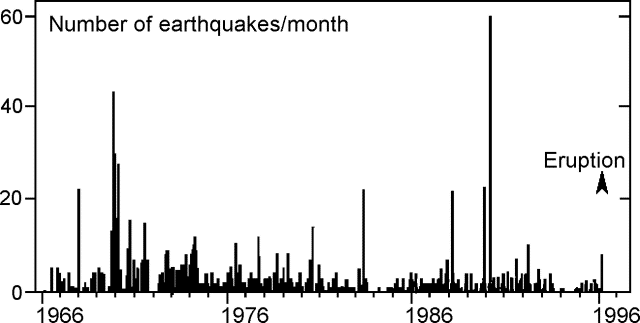 |
Figure 1. Monthly number of earthquakes of Komaga-take recorded at JMA's local seismic station in the years 1966-96. An eruption took place in early March 1996. Courtesy of JMA. |
On the morning of 6 March JMA reported that a white plume rose to 150 m above the summit and ashfall was visible for >10 km from the summit on the SSE flank. According to Tad Ui, who made observations from a helicopter during the morning of 6 March, steam-dominated eruption clouds rose from inside the craters of the 1929 eruption and also from new, 100-m-long, N-S trending fissures S of the craters. He estimated the cloud height at around 400 m. Ashfall covered new snow; no mudflows were observed. Videos taken around this time by the press and local residents showed violent, gray, ash-laden clouds jetting from newly formed fissures.
On 8 March, a white-colored plume was 900 m above the summit. By 12 March, eruptive activity declined. Post-eruption seismicity was weak: tremor was not observed from 5 March to as late as 10 March, and after 6 March small earthquakes occurred several times a day.
An aviation notice on 7 March stated that the top of the ash cloud was at ~1,500-m altitude (~300 m above the summit) and drifting SE; a notice the next day reported ash to ~1,700 m altitude drifting W. Notices were again issued on 13 and 19 March for ash clouds to ~1,300-m altitude.
Ui and other scientists from Hokkaido University will analyze new products; preliminary analysis suggested that the initially erupted tephra contained little fresh glass, and other magmatic materials appeared absent. The mass of tephra erupted in this event was estimated at ~25,000 tons.
Residents evacuated the night of 5 March were permitted to return on 8 March. Small phreatic eruptions of the kind witnessed beginning on 5 March 1996 could be precursors to larger explosions. Phreatic eruptions were observed during June 1919, and in June 1929, prior to larger events.
Information Contacts: Tadahide Ui, Hokkaido University, Grad School Sci., Kita-ku, Sapporo 060 Japan; Usu Volcano Observatory (UVO), Faculty of Science, Hokkaido University, Sohbetsu-cho, Usu-gun, Hokkaido 052-01 Japan; Volcanological Division, Seismological and Volcanological Dept, Japan Meteorological Agency (JMA), 1-3-4 Ote-machi, Chiyoda-ku, Tokyo 100 Japan; Setsuya Nakada, Volcano Research Center, Earthquake Research Institute, University of Tokyo, Yayoi 1-1-1, Bunkyo-ku, Tokyo 113, Japan (URL: http://www.eri.u-tokyo.ac.jp/VRC/index_E.html); Bureau of Meteorology, Darwin, Australia.
Additional information about the 5 March eruption
Volcanic tremor was registered for six minutes starting at 1810 on 5 March by the JMA station 4.1 km WSW of the crater. During this activity, two main vents opened on and near the S side of Showa 4-nen (1929) crater. A line of vents extending ~200 m N-S formed on the S part of the crater floor. Strong eruptive activity was observed until 7 March and then decreased. Volcanic earthquakes had increased somewhat prior to the eruption, but seismicity remained low afterwards through mid-April.
Information Contacts: Volcanological Division, Seismological and Volcanological Department, Japan Meteorological Agency (JMA), 1-3-4 Ote-machi, Chiyoda-ku, Tokyo 100 Japan.
Steaming activity continues
Activity has declined since the eruptive events of March when two vents opened on and near the S side of Showa 4-nen (1929) crater, and a line of vents extending ~200 m N-S formed on the S part of the crater floor. The height of the gas plume remained at 100-200 m. A volcanic earthquake occurred on 15 May. No volcanic tremor was observed.
Komaga-take sits 30 km N of Hakodate City (population 320,000). The andesitic stratovolcano has a 2-km-wide horseshoe-shaped caldera open to the E. The volcano has generated large pyroclastic eruptions, including major historical eruptions in 1640, 1856, and 1929. In the 1640 eruption, debris from a partial summit collapse entered the sea resulting in a tsunami that killed 700 people. Although the 1929 eruption was one of the largest 20th century eruptions in Japan, it may not have had clear geophysical precursors.
Information Contacts: Japan Meteorological Agency (JMA), Volcanological Division, Seismological and Volcanological Department, 1-3-4 Ote-machi, Chiyoda-ku, Tokyo 100, Japan.
Phreatic eruption spreads ash 25 October
The Japan Meteorological Agency (JMA) issued an advisory and three observation reports concerning Hokkaido-Komaga-take volcano on 25 October following a small-scale phreatic eruption that began at 0912 the same day. Ash rose in a column to a height of ~1,200 m above the crater. The eruptive activity soon declined. There were no report of injuries or damage caused by the eruption, and no evacuation order was issued.
Volcanologists surveyed the activity from a helicopter the afternoon of 25 October (figure 2). They reported that the eruption originated from the same crater that opened during the 1929 eruption, which was also the site of the March 1996 eruption. Ash covered a significant area around and to the E of the crater. The scale of this eruption apparently was smaller than that of the March 1996 eruption.
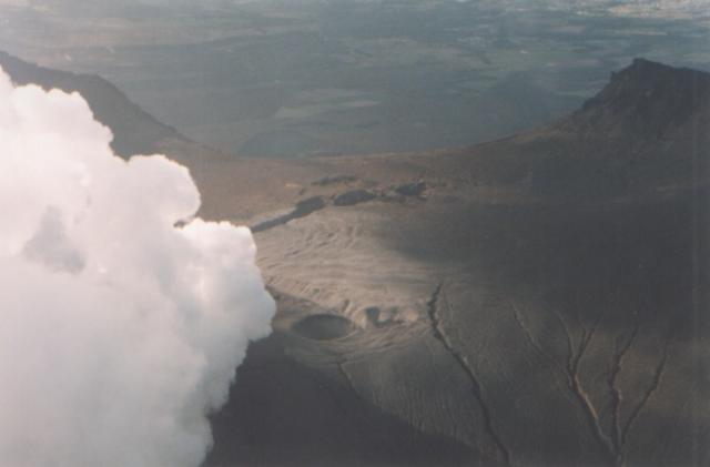 |
Figure 2. An aerial view of Komaga-take showing fuming activity from the 1929 Crater about 6 hours after the 25 October 1998 eruption. View is from the SE looking towards the Komanose Rim (back) and the Sawaradake Rim (back right). The 1942 Large Fissure (middle, diagonal) and the 1996 Southern Fissure Crater (middle center) can also be seen. Hyoutan Crater (front center) is adjacent to the 1929 Crater. Photograph by Bousai Heli; courtesy of Hiromu Okada, Usu Volcano Observatory. |
Volcanic tremor lasting six minutes was associated with this eruption. In addition, five volcanic earthquakes were recorded in the 12 hours following the first eruption signs.
Komaga-take is located 30 km N of Hakodate City (population 320,000). The andesitic stratovolcano has a 2-km-wide horseshoe-shaped caldera open to the E. The volcano has generated large pyroclastic eruptions, including major historical eruptions in 1640, 1856, and 1929. In the 1640 eruption, debris from a partial summit collapse entered the sea resulting in a tsunami that killed 700 people. Although the 1929 eruption was one of the largest 20th-century eruptions in Japan, it may not have had clear geophysical precursors.
Information Contacts: J. Miyamura, Sapporo District, Japan Meteorological Agency, 1-3-4 Ote-machi, Chiyoda-ku, Tokyo 100, Japan; Hiromu Okada, Usu Volcano Observatory, Institute of Seismology and Volcanology, Hokkaido University, Sohbetsu-cho, Hokkaido 052-0103, Japan.
Small eruptions on 4 and 28 September, the first since October 1998
The last reported volcanic activity at Komaga-take was a small-scale phreatic eruption on 25 October 1998 (BGVN 23:09). After 1998 there were no reports of volcanism until September 2000 when small eruptions occurred on the 4th and 28th.
Komaga-take, about 120 km SW of the prefectural capital Sapporo, erupted at 2214 on 4 September. According to a Bernama news article, Hokkaido University Professor Hiromu Okada stated that he did not see any fresh cracks or crevices in the volcano when he observed it by helicopter the day after the eruption. He added that "there were many cinders popping out in a wide area ." The same day the Sapporo District Meteorological Observatory reported that a column of "smoke" rose up to 500 m above the volcano. According to the Bernama article, local authorities issued volcano warnings to the 60,000 residents of Mori, ~10 km NW of the volcano, and four other nearby towns. An Associated Press article reported that according to the observatory, a small amount of ash was observed on the ground in a town NW of the volcano. The Tokyo VAAC reported that no ash cloud was visible on GMS-5 imagery.
The volcano erupted for a second time on 28 September, but inclement weather inhibited observations. According to an Associated Press article, Hisao Hashimoto stated that a light coating of ash covered cars in a town at the base of the volcano. There were no reports of injuries or damage.
Information Contacts: Tokyo VAAC (URL: http://ds.data.jma.go.jp/svd/vaac/data/); Bernama-dpa (URL: http://www.asiapac.net/bernama/prwire/); Associated Press (URL: http://www.ap.org/).
This compilation of synonyms and subsidiary features may not be comprehensive. Features are organized into four major categories: Cones, Craters, Domes, and Thermal Features. Synonyms of features appear indented below the primary name. In some cases additional feature type, elevation, or location details are provided.
Synonyms |
||||
| Utiura-dake | Uchiura-dake | Komaga-take | Kayabenobori | Oshima-Fuji | Sawara-dake | ||||
Craters |
||||
| Feature Name | Feature Type | Elevation | Latitude | Longitude |
| Ansei | Crater | |||
| Da'enkei | Crater | |||
| Hisagogata | Crater | |||
| Mayugata | Crater | |||
| Oshidashizawa | Crater | |||
|
|
||||||||||||||||||||||||
There is data available for 19 confirmed Holocene eruptive periods.
2000 Sep 4 - 2000 Nov 8 Confirmed Eruption Max VEI: 1
| Episode 1 | Eruption Episode | |||||||||||||||||||||||||||||||||||||||||||||
|---|---|---|---|---|---|---|---|---|---|---|---|---|---|---|---|---|---|---|---|---|---|---|---|---|---|---|---|---|---|---|---|---|---|---|---|---|---|---|---|---|---|---|---|---|---|
| 2000 Sep 4 - 2000 Nov 8 | Evidence from Observations: Reported | ||||||||||||||||||||||||||||||||||||||||||||
|
List of 7 Events for Episode 1
| |||||||||||||||||||||||||||||||||||||||||||||
1998 Oct 25 - 1998 Oct 25 Confirmed Eruption Max VEI: 2
| Episode 1 | Eruption Episode | 1996 crater | ||||||||||||||||||||||||||||||||||||||||||||
|---|---|---|---|---|---|---|---|---|---|---|---|---|---|---|---|---|---|---|---|---|---|---|---|---|---|---|---|---|---|---|---|---|---|---|---|---|---|---|---|---|---|---|---|---|---|
| 1998 Oct 25 - 1998 Oct 25 | Evidence from Observations: Reported | ||||||||||||||||||||||||||||||||||||||||||||
|
List of 7 Events for Episode 1 at 1996 crater
| |||||||||||||||||||||||||||||||||||||||||||||
1996 Mar 5 - 1996 Mar 12 (?) Confirmed Eruption Max VEI: 1
| Episode 1 | Eruption Episode | 1929 crater and summit crater fissure | ||||||||||||||||||||||||||||||||||||||||||||||||||||||
|---|---|---|---|---|---|---|---|---|---|---|---|---|---|---|---|---|---|---|---|---|---|---|---|---|---|---|---|---|---|---|---|---|---|---|---|---|---|---|---|---|---|---|---|---|---|---|---|---|---|---|---|---|---|---|---|
| 1996 Mar 5 - 1996 Mar 12 (?) | Evidence from Observations: Reported | ||||||||||||||||||||||||||||||||||||||||||||||||||||||
|
List of 9 Events for Episode 1 at 1929 crater and summit crater fissure
| |||||||||||||||||||||||||||||||||||||||||||||||||||||||
1942 Nov 16 - 1942 Nov 18 Confirmed Eruption Max VEI: 3
| Episode 1 | Eruption Episode | NW-SE 1.6-km fissure | ||||||||||||||||||||||||||||||||||||||||||||||||||||||||||||||||
|---|---|---|---|---|---|---|---|---|---|---|---|---|---|---|---|---|---|---|---|---|---|---|---|---|---|---|---|---|---|---|---|---|---|---|---|---|---|---|---|---|---|---|---|---|---|---|---|---|---|---|---|---|---|---|---|---|---|---|---|---|---|---|---|---|---|
| 1942 Nov 16 - 1942 Nov 18 | Evidence from Observations: Reported | ||||||||||||||||||||||||||||||||||||||||||||||||||||||||||||||||
|
List of 11 Events for Episode 1 at NW-SE 1.6-km fissure
| |||||||||||||||||||||||||||||||||||||||||||||||||||||||||||||||||
1937 Mar 17 - 1937 Mar 19 Confirmed Eruption Max VEI: 1
| Episode 1 | Eruption Episode | ||||||||||||||||||||||||||||||
|---|---|---|---|---|---|---|---|---|---|---|---|---|---|---|---|---|---|---|---|---|---|---|---|---|---|---|---|---|---|---|
| 1937 Mar 17 - 1937 Mar 19 | Evidence from Observations: Reported | |||||||||||||||||||||||||||||
|
List of 4 Events for Episode 1
| ||||||||||||||||||||||||||||||
[ 1935 Oct 15 - 1935 Oct 15 ] Uncertain Eruption
| Episode 1 | Eruption Episode | ||||||||||||||||||||
|---|---|---|---|---|---|---|---|---|---|---|---|---|---|---|---|---|---|---|---|---|
| 1935 Oct 15 - 1935 Oct 15 | Evidence from Unknown | |||||||||||||||||||
|
List of 2 Events for Episode 1
| ||||||||||||||||||||
[ 1935 Jul 8 ] Discredited Eruption
1929 Jun 17 - 1929 Sep 6 Confirmed Eruption Max VEI: 4
| Episode 1 | Eruption Episode | SE and NE of Ansei Crater, Layer Ko-a | |||||||||||||||||||||||||||||||||||||||||||||||||||||||||||||||||||||||||||||||||||||||||
|---|---|---|---|---|---|---|---|---|---|---|---|---|---|---|---|---|---|---|---|---|---|---|---|---|---|---|---|---|---|---|---|---|---|---|---|---|---|---|---|---|---|---|---|---|---|---|---|---|---|---|---|---|---|---|---|---|---|---|---|---|---|---|---|---|---|---|---|---|---|---|---|---|---|---|---|---|---|---|---|---|---|---|---|---|---|---|---|---|---|---|
| 1929 Jun 17 - 1929 Sep 6 | Evidence from Observations: Reported | |||||||||||||||||||||||||||||||||||||||||||||||||||||||||||||||||||||||||||||||||||||||||
|
List of 16 Events for Episode 1 at SE and NE of Ansei Crater, Layer Ko-a
| ||||||||||||||||||||||||||||||||||||||||||||||||||||||||||||||||||||||||||||||||||||||||||
1928 Mar 28 Confirmed Eruption Max VEI: 1
| Episode 1 | Eruption Episode | |||||||||||||||||||||||||
|---|---|---|---|---|---|---|---|---|---|---|---|---|---|---|---|---|---|---|---|---|---|---|---|---|---|
| 1928 Mar 28 - Unknown | Evidence from Observations: Reported | ||||||||||||||||||||||||
|
List of 3 Events for Episode 1
| |||||||||||||||||||||||||
1924 Jul 31 Confirmed Eruption Max VEI: 2
| Episode 1 | Eruption Episode | ||||||||||||||||||||||||||||||
|---|---|---|---|---|---|---|---|---|---|---|---|---|---|---|---|---|---|---|---|---|---|---|---|---|---|---|---|---|---|---|
| 1924 Jul 31 - Unknown | Evidence from Observations: Reported | |||||||||||||||||||||||||||||
|
List of 4 Events for Episode 1
| ||||||||||||||||||||||||||||||
1923 Feb 27 - 1923 Mar 15 Confirmed Eruption Max VEI: 2
| Episode 1 | Eruption Episode | ||||||||||||||||||||
|---|---|---|---|---|---|---|---|---|---|---|---|---|---|---|---|---|---|---|---|---|
| 1923 Feb 27 - 1923 Mar 15 | Evidence from Observations: Reported | |||||||||||||||||||
|
List of 2 Events for Episode 1
| ||||||||||||||||||||
1922 May 22 Confirmed Eruption Max VEI: 2
| Episode 1 | Eruption Episode | ||||||||||||||||||||
|---|---|---|---|---|---|---|---|---|---|---|---|---|---|---|---|---|---|---|---|---|
| 1922 May 22 - Unknown | Evidence from Observations: Reported | |||||||||||||||||||
|
List of 2 Events for Episode 1
| ||||||||||||||||||||
1919 Jun 17 - 1919 Jul 26 Confirmed Eruption Max VEI: 2
| Episode 1 | Eruption Episode | SE of Ansei Crater | |||||||||||||||||||||||||||||
|---|---|---|---|---|---|---|---|---|---|---|---|---|---|---|---|---|---|---|---|---|---|---|---|---|---|---|---|---|---|---|
| 1919 Jun 17 - 1919 Jul 26 | Evidence from Observations: Reported | |||||||||||||||||||||||||||||
|
List of 4 Events for Episode 1 at SE of Ansei Crater
| ||||||||||||||||||||||||||||||
1905 Aug 19 - 1905 Sep 1 (?) Confirmed Eruption Max VEI: 2
| Episode 1 | Eruption Episode | South of Ansei Crater | |||||||||||||||||||||||||||||
|---|---|---|---|---|---|---|---|---|---|---|---|---|---|---|---|---|---|---|---|---|---|---|---|---|---|---|---|---|---|---|
| 1905 Aug 19 - 1905 Sep 1 (?) | Evidence from Observations: Reported | |||||||||||||||||||||||||||||
|
List of 4 Events for Episode 1 at South of Ansei Crater
| ||||||||||||||||||||||||||||||
1888 Apr 14 Confirmed Eruption Max VEI: 2
| Episode 1 | Eruption Episode | NW side of 1856 (Ansei) crater | |||||||||||||||||||
|---|---|---|---|---|---|---|---|---|---|---|---|---|---|---|---|---|---|---|---|---|
| 1888 Apr 14 - Unknown | Evidence from Observations: Reported | |||||||||||||||||||
|
List of 2 Events for Episode 1 at NW side of 1856 (Ansei) crater
| ||||||||||||||||||||
1856 Sep 25 Confirmed Eruption Max VEI: 4
| Episode 1 | Eruption Episode | Ansei Crater, Tephra layer Ko-c1 | ||||||||||||||||||||||||||||||||||||||||||||||||||||||
|---|---|---|---|---|---|---|---|---|---|---|---|---|---|---|---|---|---|---|---|---|---|---|---|---|---|---|---|---|---|---|---|---|---|---|---|---|---|---|---|---|---|---|---|---|---|---|---|---|---|---|---|---|---|---|---|
| 1856 Sep 25 - Unknown | Evidence from Observations: Reported | ||||||||||||||||||||||||||||||||||||||||||||||||||||||
|
List of 9 Events for Episode 1 at Ansei Crater, Tephra layer Ko-c1
| |||||||||||||||||||||||||||||||||||||||||||||||||||||||
[ 1784 Feb 8 ] Uncertain Eruption
| Episode 1 | Eruption Episode | ||||||||||||||||||||
|---|---|---|---|---|---|---|---|---|---|---|---|---|---|---|---|---|---|---|---|---|
| 1784 Feb 8 - Unknown | Evidence from Unknown | |||||||||||||||||||
|
List of 2 Events for Episode 1
| ||||||||||||||||||||
[ 1765 ] Uncertain Eruption
| Episode 1 | Eruption Episode | ||||||||||||||||||||
|---|---|---|---|---|---|---|---|---|---|---|---|---|---|---|---|---|---|---|---|---|
| 1765 - Unknown | Evidence from Unknown | |||||||||||||||||||
|
List of 2 Events for Episode 1
| ||||||||||||||||||||
[ 1710 Jun 27 ] Uncertain Eruption
| Episode 1 | Eruption Episode | ||||
|---|---|---|---|---|
| 1710 Jun 27 - Unknown | Evidence from Unknown | |||
1694 Jul 4 - 1694 Jul 6 Confirmed Eruption Max VEI: 4
| Episode 1 | Eruption Episode | Tephra layer Ko-c2 | |||||||||||||||||||||||||||||
|---|---|---|---|---|---|---|---|---|---|---|---|---|---|---|---|---|---|---|---|---|---|---|---|---|---|---|---|---|---|---|
| 1694 Jul 4 - 1694 Jul 6 | Evidence from Observations: Reported | |||||||||||||||||||||||||||||
|
List of 4 Events for Episode 1 at Tephra layer Ko-c2
| ||||||||||||||||||||||||||||||
1640 Jul 31 - 1640 Oct 9 Confirmed Eruption Max VEI: 5
| Episode 1 | Eruption Episode | Tephra layer Ko-d | ||||||||||||||||||||||||||||||||||||||||||||||||||||||||||||||||||||||||||
|---|---|---|---|---|---|---|---|---|---|---|---|---|---|---|---|---|---|---|---|---|---|---|---|---|---|---|---|---|---|---|---|---|---|---|---|---|---|---|---|---|---|---|---|---|---|---|---|---|---|---|---|---|---|---|---|---|---|---|---|---|---|---|---|---|---|---|---|---|---|---|---|---|---|---|---|
| 1640 Jul 31 - 1640 Oct 9 | Evidence from Observations: Reported | ||||||||||||||||||||||||||||||||||||||||||||||||||||||||||||||||||||||||||
|
List of 13 Events for Episode 1 at Tephra layer Ko-d
| |||||||||||||||||||||||||||||||||||||||||||||||||||||||||||||||||||||||||||
4350 BCE (?) Confirmed Eruption Max VEI: 4
| Episode 1 | Eruption Episode | Tephra layer Ko-f | |||||||||||||||||||||||||||||
|---|---|---|---|---|---|---|---|---|---|---|---|---|---|---|---|---|---|---|---|---|---|---|---|---|---|---|---|---|---|---|
| 4350 BCE (?) - Unknown | Evidence from Isotopic: 14C (calibrated) | |||||||||||||||||||||||||||||
|
List of 4 Events for Episode 1 at Tephra layer Ko-f
| ||||||||||||||||||||||||||||||
4500 BCE ± 150 years Confirmed Eruption
| Episode 1 | Eruption Episode | NS1 and NS2 tephras | |||||||||||||||||||
|---|---|---|---|---|---|---|---|---|---|---|---|---|---|---|---|---|---|---|---|---|
| 4500 BCE ± 150 years - Unknown | Evidence from Correlation: Tephrochronology | |||||||||||||||||||
|
List of 2 Events for Episode 1 at NS1 and NS2 tephras
| ||||||||||||||||||||
4600 BCE ± 50 years Confirmed Eruption Max VEI: 5
| Episode 1 | Eruption Episode | Tephra layer Ko-g | |||||||||||||||||||||||||||||
|---|---|---|---|---|---|---|---|---|---|---|---|---|---|---|---|---|---|---|---|---|---|---|---|---|---|---|---|---|---|---|
| 4600 BCE ± 50 years - Unknown | Evidence from Isotopic: 14C (calibrated) | |||||||||||||||||||||||||||||
|
List of 4 Events for Episode 1 at Tephra layer Ko-g
| ||||||||||||||||||||||||||||||
There is data available for 2 deformation periods. Expand each entry for additional details.
| Start Date: 1997 Nov | Stop Date: 1998 May | Direction: Subsidence | Method: GPS, Leveling |
| Magnitude: 6.000 cm | Spatial Extent: Unknown | Latitude: Unknown | Longitude: Unknown |
Remarks: Ground subsidence is associated with the 1996 and 1998 phreatic eruptions. | |||
Reference List: Jousset et al. 2000.
Full References:
Jousset, P., H. Mori, and H. Okada, 2000. Possible magma intrusion revealed by temporal gravity, ground deformation and ground temperature observations at Mount Komagatake (Hokkaido) during the 1996-1998 crisis. Geophysical Journal International, 143, 557-574. https://doi.org/10.1046/j.1365-246X.2000.00218.x
| Start Date: 1997 May | Stop Date: 1997 Nov | Direction: Subsidence | Method: GPS, Leveling |
| Magnitude: 2.000 cm | Spatial Extent: Unknown | Latitude: Unknown | Longitude: Unknown |
Remarks: Ground subsidence is associated with the 1996 and 1998 phreatic eruptions. | |||
Reference List: Jousset et al. 2000.
Full References:
Jousset, P., H. Mori, and H. Okada, 2000. Possible magma intrusion revealed by temporal gravity, ground deformation and ground temperature observations at Mount Komagatake (Hokkaido) during the 1996-1998 crisis. Geophysical Journal International, 143, 557-574. https://doi.org/10.1046/j.1365-246X.2000.00218.x
There is no Emissions History data available for Hokkaido-Komagatake.
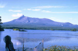 Komagatake on the Oshima Peninsula of southern Hokkaido rises to the N above Lake Onuma and is one of the most active volcanoes of Japan's northernmost island. The summit formed as a result of edifice collapse and hummocky debris avalanche deposits were responsible for the formation of Lake Onuma. A period of more frequent explosive activity began with a major explosive eruption in 1640.
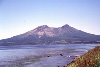 The two summit peaks of Komagatake, seen here from the NW, are remnants of a scarp formed by prehistoric flank collapse towards the NW. Several episodes of growth and collapse have occurred, with the most recent in 1640 when the flank collapsed towards the E.
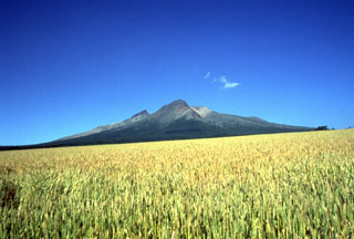 From the WSW the highest visible point of Komagatake is the rim of a scarp that opens to the east (right). The sharp peak to the left is Kengamine, the summit and part of the rear rim of the scarp.
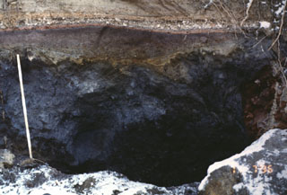 This outcrop, 5 km SW of the summit of Komagatake, shows a cross section of deposits from the 1640 eruption. The dark section at the base is a debris avalanche deposit produced by collapse of the summit. The reddish-gray section above the ruler is a blast deposit related to the collapse. The thin white unit above the blast deposit is a layer of airfall pumice, which is much thicker at other locations closer to the axis of tephra deposition. The top of the section is a pyroclastic flow deposit.
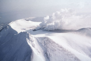 The 1996 Komagatake eruption occurred at several vents seen producing plumes in this 7 March view of the summit from the W. A phreatic eruption began the evening of 5 March from the 1929 crater and a fissure, depositing the ash seen here. Activity consisted of steam-rich ash plumes that declined after 12 March.
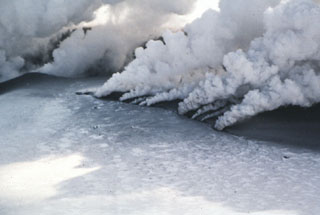 Gas-and-steam plumes emanate from a new eruptive fissure cutting the summit of Japan's Komagatake volcano on 7 March 1996. A phreatic eruption began the evening of the 5th and deposited ash onto snow. The eruption took place from the 1929 crater and from a 200-m-long N-S fissure on the S flank. Eruptive activity, producing steam-rich ash plumes, was strong until 7 March and declined after 12 March.
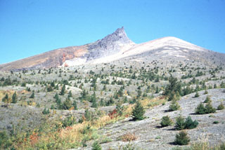 The dune-like surface in the foreground consists of pyroclastic surge deposits from the 1929 eruption of Komagatake. This 1991 S-flank view shows Kengamine (center), the summit of Komagatake, which is the rim of a large scarp that formed when the summit collapsed to the east (right).
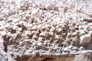 A pyroclastic flow deposit from the 1929 eruption of Komagatake volcano, on the northern Japanese island of Hokkaido, overlies a brown pre-eruption surface. The upper part of the deposit contains large pumice that lacks fine-grained material between the clasts and the underlying unit is enriched in fine-grained material. A geological hammer provides scale.
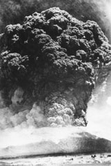 A Plinian ash plume rising above the summit of Komagatake on 17 June 1929, seen here from the town of Mori, NW of the volcano. This was one of the largest eruptions from Komagatake in historical time, producing pumice-rich pyroclastic flows that descended out to 8 km from the crater, and a thick blanket of ash and pumice that caused extensive damage. The maximum reported plume height was 13 km. Activity ceased on 19 June before briefly resuming on 6 September.
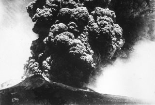 A Plinian eruption column rises above Komagatake volcano in northern Japan on 17 June, the beginning of a major eruption in 1929 that was one of the largest in historical times. The ash plume rose to a maximum height of 13 km and produced thick, pumice-rich fall deposits around the volcano. The eruption also produced pyroclastic flows that traveled down the flanks. This photo is from the shores of Onuma lake to the south.
 Pumice from the 1929 eruption of Komagatake covers streets and buildings in the town of Shikabe.
The maps shown below have been scanned from the GVP map archives and include the volcano on this page. Clicking on the small images will load the full 300 dpi map. Very small-scale maps (such as world maps) are not included. The maps database originated over 30 years ago, but was only recently updated and connected to our main database. We welcome users to tell us if they see incorrect information or other problems with the maps; please use the Contact GVP link at the bottom of the page to send us email.
The following 3 samples associated with this volcano can be found in the Smithsonian's NMNH Department of Mineral Sciences collections, and may be availble for research (contact the Rock and Ore Collections Manager). Catalog number links will open a window with more information.
| Catalog Number | Sample Description | Lava Source | Collection Date |
|---|---|---|---|
| NMNH 101493 | Volcanic Rock | -- | -- |
| NMNH 101494 | Glass | -- | -- |
| NMNH 116397-2 | Pumice | -- | -- |
| Copernicus Browser | The Copernicus Browser replaced the Sentinel Hub Playground browser in 2023, to provide access to Earth observation archives from the Copernicus Data Space Ecosystem, the main distribution platform for data from the EU Copernicus missions. |
| MIROVA | Middle InfraRed Observation of Volcanic Activity (MIROVA) is a near real time volcanic hot-spot detection system based on the analysis of MODIS (Moderate Resolution Imaging Spectroradiometer) data. In particular, MIROVA uses the Middle InfraRed Radiation (MIR), measured over target volcanoes, in order to detect, locate and measure the heat radiation sourced from volcanic activity. |
| MODVOLC Thermal Alerts | Using infrared satellite Moderate Resolution Imaging Spectroradiometer (MODIS) data, scientists at the Hawai'i Institute of Geophysics and Planetology, University of Hawai'i, developed an automated system called MODVOLC to map thermal hot-spots in near real time. For each MODIS image, the algorithm automatically scans each 1 km pixel within it to check for high-temperature hot-spots. When one is found the date, time, location, and intensity are recorded. MODIS looks at every square km of the Earth every 48 hours, once during the day and once during the night, and the presence of two MODIS sensors in space allows at least four hot-spot observations every two days. Each day updated global maps are compiled to display the locations of all hot spots detected in the previous 24 hours. There is a drop-down list with volcano names which allow users to 'zoom-in' and examine the distribution of hot-spots at a variety of spatial scales. |
|
WOVOdat
Single Volcano View Temporal Evolution of Unrest Side by Side Volcanoes |
WOVOdat is a database of volcanic unrest; instrumentally and visually recorded changes in seismicity, ground deformation, gas emission, and other parameters from their normal baselines. It is sponsored by the World Organization of Volcano Observatories (WOVO) and presently hosted at the Earth Observatory of Singapore.
GVMID Data on Volcano Monitoring Infrastructure The Global Volcano Monitoring Infrastructure Database GVMID, is aimed at documenting and improving capabilities of volcano monitoring from the ground and space. GVMID should provide a snapshot and baseline view of the techniques and instrumentation that are in place at various volcanoes, which can be use by volcano observatories as reference to setup new monitoring system or improving networks at a specific volcano. These data will allow identification of what monitoring gaps exist, which can be then targeted by remote sensing infrastructure and future instrument deployments. |
| Volcanic Hazard Maps | The IAVCEI Commission on Volcanic Hazards and Risk has a Volcanic Hazard Maps database designed to serve as a resource for hazard mappers (or other interested parties) to explore how common issues in hazard map development have been addressed at different volcanoes, in different countries, for different hazards, and for different intended audiences. In addition to the comprehensive, searchable Volcanic Hazard Maps Database, this website contains information about diversity of volcanic hazard maps, illustrated using examples from the database. This site is for educational purposes related to volcanic hazard maps. Hazard maps found on this website should not be used for emergency purposes. For the most recent, official hazard map for a particular volcano, please seek out the proper institutional authorities on the matter. |
| IRIS seismic stations/networks | Incorporated Research Institutions for Seismology (IRIS) Data Services map showing the location of seismic stations from all available networks (permanent or temporary) within a radius of 0.18° (about 20 km at mid-latitudes) from the given location of Hokkaido-Komagatake. Users can customize a variety of filters and options in the left panel. Note that if there are no stations are known the map will default to show the entire world with a "No data matched request" error notice. |
| UNAVCO GPS/GNSS stations | Geodetic Data Services map from UNAVCO showing the location of GPS/GNSS stations from all available networks (permanent or temporary) within a radius of 20 km from the given location of Hokkaido-Komagatake. Users can customize the data search based on station or network names, location, and time window. Requires Adobe Flash Player. |
| DECADE Data | The DECADE portal, still in the developmental stage, serves as an example of the proposed interoperability between The Smithsonian Institution's Global Volcanism Program, the Mapping Gas Emissions (MaGa) Database, and the EarthChem Geochemical Portal. The Deep Earth Carbon Degassing (DECADE) initiative seeks to use new and established technologies to determine accurate global fluxes of volcanic CO2 to the atmosphere, but installing CO2 monitoring networks on 20 of the world's 150 most actively degassing volcanoes. The group uses related laboratory-based studies (direct gas sampling and analysis, melt inclusions) to provide new data for direct degassing of deep earth carbon to the atmosphere. |
| Large Eruptions of Hokkaido-Komagatake | Information about large Quaternary eruptions (VEI >= 4) is cataloged in the Large Magnitude Explosive Volcanic Eruptions (LaMEVE) database of the Volcano Global Risk Identification and Analysis Project (VOGRIPA). |
| EarthChem | EarthChem develops and maintains databases, software, and services that support the preservation, discovery, access and analysis of geochemical data, and facilitate their integration with the broad array of other available earth science parameters. EarthChem is operated by a joint team of disciplinary scientists, data scientists, data managers and information technology developers who are part of the NSF-funded data facility Integrated Earth Data Applications (IEDA). IEDA is a collaborative effort of EarthChem and the Marine Geoscience Data System (MGDS). |

