SVERT reported that a weak thermal anomaly over Tiatia was detected in satellite images on 1 September. The Aviation Color Code remained at Yellow.
Source: Sakhalin Volcanic Eruption Response Team (SVERT)
Thermal anomalies detected during February-June 2010
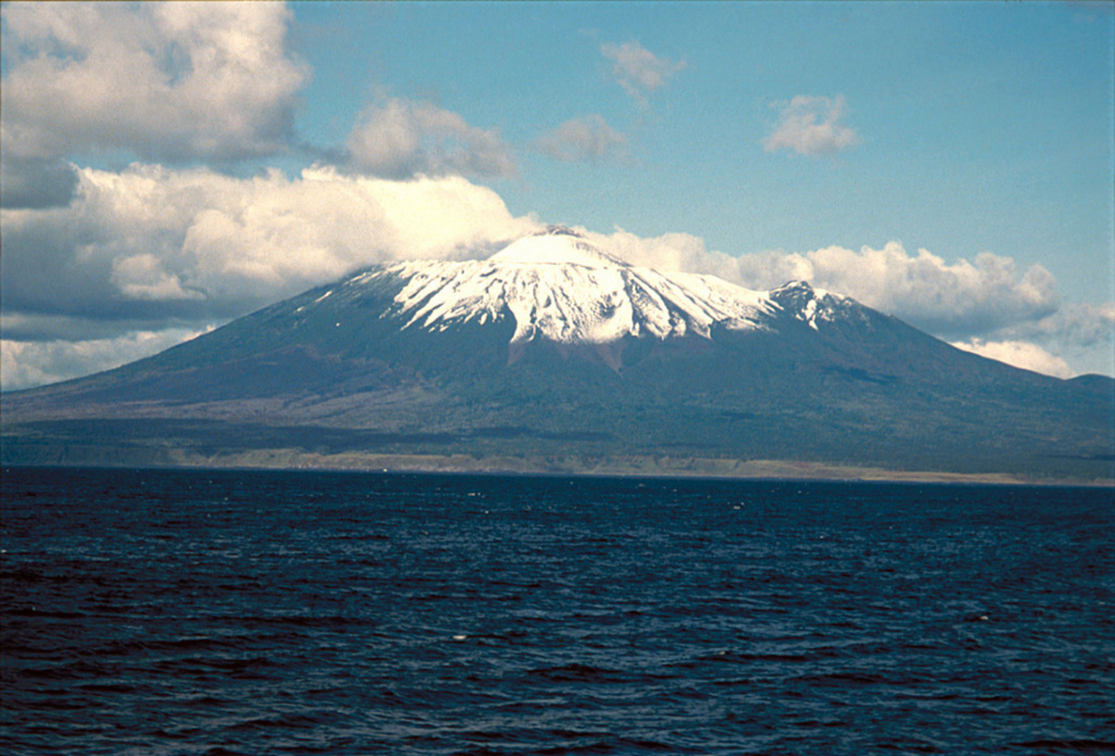
No eruptive or thermal activity is known on Tiatia between 1988 and the beginning of 2010, but thermal anomalies began in February 2010. During its last activity, in 1988, Tiatia displayed steaming in many parts of the crater (SEAN 13:11). The volcano, whose alternate names include Tyatya and Chacha-dake, sits near the NE margin of Kunashir Island (figures 1-3).
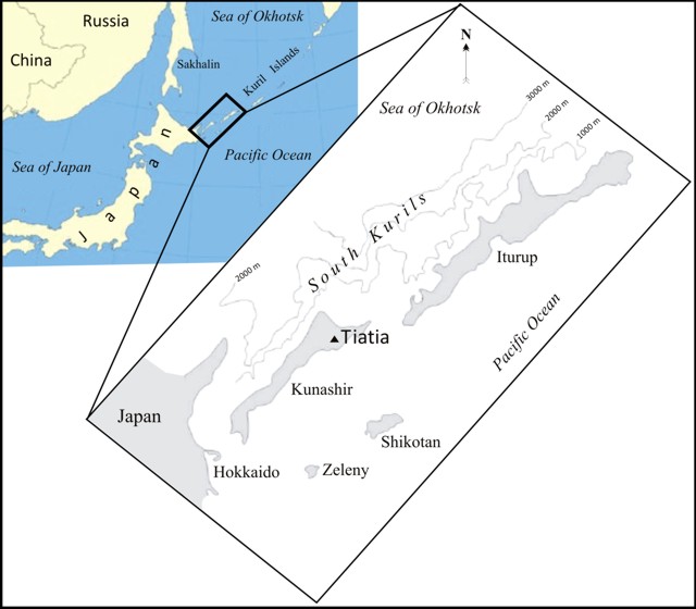 |
Figure 1. A map showing the location of Tiatia volcano very near the southern end of the Kurile island chain. For scale, NE-trending Kunashir Island is 123 km long. Tiatia and the city of Sapporo (on the NW side of Hokkaido Island, Japan) are ~ 600 km apart. |
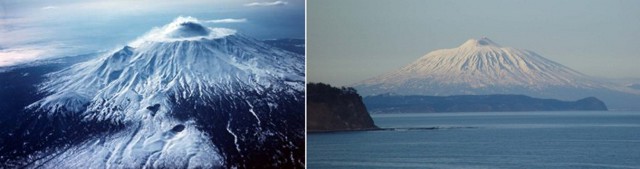 |
Figure 2. Two aerial views of Tiatia disclose its striking morphology. (left) View in 1973 showing the symmetrical caldera rim, which encircles an axially symmetrical inner cone with a broken top; scoria cones lie on the SE slope (mid- to foreground). (right) Viewed from the S in 2008 on a clear day. Courtesy of volcanologist Anatoly Khrenov (1973 photo) and blogger Udachnik (2008 photo). |
 |
Figure 3. An ASTER image of Tiatia taken on 29 June 2006 shows considerable snow surrounding the crater and down the caldera's flanks. Where visible, the slopes generally appear densely vegetated, except for the crater, some upslope areas, and around minor cones on the lower right and upper center. N is towards the top; the summit caldera is ~ 2 km in diameter. Courtesy of Aster Volcano Archive. |
According to the Sakhalin Volcanic Eruption Response Team (SVERT), thermal anomalies were detected during 2010 by satellite on 9 February, 31 May, 10 June, 19 June, and 25 June. Tiatia lacks a local seismic instrument and satellites are the primary tool used for monitoring. The satellites used in detecting these anomalies was not identified. MODVOLC thermal alerts were absent, a circumstance that could be explained by their reasonably high threshold in order to minimize the mis-identification of thermal activity.
Information Contacts: Sakhalin Volcanic Eruption Response Team (SVERT), Alexander Rybin, IMGG FEB RAS, Yuzhno-Sakhalinsk (URL: http://www.imgg.ru/); The ASTER Volcano Archive (AVA), NASA Jet Propulsion Lab, California Institute of Technology (URL: http://ava.jpl.nasa.gov/volcano.asp); Hawai'i Institute of Geophysics and Planetology (HIGP) Thermal Alerts System, School of Ocean and Earth Science and Technology (SOEST), Univ. of Hawai'i, 2525 Correa Road, Honolulu, HI 96822, USA (URL: http://modis.higp.hawaii.edu/); Udachnik (URL: http://dirty.ru/comments/245960).
2012: August
2010: February
| June
SVERT reported that a weak thermal anomaly over Tiatia was detected in satellite images on 1 September. The Aviation Color Code remained at Yellow.
Source: Sakhalin Volcanic Eruption Response Team (SVERT)
SVERT reported that a thermal anomaly from Tiatia volcano was detected by satellite on 25 June.
Source: Sakhalin Volcanic Eruption Response Team (SVERT)
SVERT reported that a thermal anomaly from Tiatia, a volcano on NE Kunashir Island, was detected by satellite on 19 June. Tiatia does not have a seismic network; satellite image observations are the primary tool for monitoring many of the Kuril Islands volcanoes.
Source: Sakhalin Volcanic Eruption Response Team (SVERT)
SVERT reported that a thermal anomaly from Tiatia was detected by satellite on 10 June. Tiatia does not have a seismic network; satellite image observations are the primary tool for monitoring many of the Kurile Islands volcanoes.
Source: Sakhalin Volcanic Eruption Response Team (SVERT)
SVERT reported that a thermal anomaly from Tiatia was detected by satellite on 31 May. Tiatia does not have a seismic network; satellite image observations are the primary tool for monitoring many of the Kurile Islands volcanoes.
Source: Sakhalin Volcanic Eruption Response Team (SVERT)
SVERT reported that a weak thermal anomaly from Tiatia was detected by satellite on 9 February.
Source: Sakhalin Volcanic Eruption Response Team (SVERT)
Reports are organized chronologically and indexed below by Month/Year (Publication Volume:Number), and include a one-line summary. Click on the index link or scroll down to read the reports.
Frequent explosions generate 5-km-high plume and cause ashfall
Card 1677 (16 July 1973) Loud explosions and heavy local ashfall
The Tiatia volcano began erupting several months ago . . . . During the current activity a crater has formed at the foothills of the eastern slope and is ejecting ash at 1-second intervals. The eruption cloud reaches a height of 5 km above the summit, and flames can be observed at night. The explosions are audible up to a distance of 50 km from the volcano, and the depth of ash near the volcano measures up to 60 cm thick.
Card 1684 (27 July 1973) Eruption cloud rises to 5-6 km; explosions every 40-60 seconds
After lying dormant since 1812, [Tiatia] erupted on 14 July. The volcano has been continually throwing out fire and ash every 1.5-2 minutes, and the color of the island changed from green to a dirty gray in the space of two days.
This eruption . . . was preceded by a series of earthquakes of considerable magnitude. A very strong shock occurred on 17 June, and a second, stronger earthquake followed a week later.
On the second day of the eruption it was observed that the eruption cloud reached a height of 5,000-6,000 m, and that the explosions were occurring every 40-60 seconds.
Information Contacts:
Card 1677 (16 July 1973) Y. M. Doubik, IV.
Card 1684 (27 July 1973) Y. M. Doubik, IV.
600-m vapor column
The crew of a JMSA patrol boat observed a white vapor column rising about 600 m above the summit of Tiatia on the morning of [21] July. Tiatia last erupted in 1973, after 161 years of quiet. [Increased thermal activity between 1974 and 1977 melted snow and emitted vapor plumes but produced no tephra (Markhinin, 1984).]
Further Reference. Markhinin, E.K., 1984, On the state of Kunashir Island volcanoes (March, 1974-May, 1982): Volcanology and Seismology, v. 5, no. 1, p. 45-52 (English translation); 1983, no. 1, p. 43-51 (in Russian).
Information Contacts: Reuters.
Explosion sound and vapor cloud
Residents of the E end of Hokkaido heard an explosion on 20 July at 1325. The explosion was not recorded by seismographs or microbarographs in E Hokkaido. Tiatia, approximately 50 km to the E, was obscured by fog. The next morning, the crew of the JMSA ship Kunasiri observed a white cloud rising 600 m from Tiatia, but heard no explosions. No ashfall was found (in Japan) on 20 or 21 July.
Information Contacts: JMA, Tokyo.
Vapor emission and glow
The crew of a Japanese fishing boat cruising near Kunashir Island observed "smoke" rising from Tiatia on 10 June. During the night of 24 June, an orange glare was observed in the direction of the volcano from [JMA's Nemuro Weather Station], 120 km away. No additional activity has been reported.
Information Contacts: Kyodo Radio, Tokyo.
Moderate fumarolic activity from the summit crater
"Aerial inspection on 20 September of the volcanoes in the S and central Kuril Islands revealed that Tiatia's summit crater was in a state of moderate fumarolic activity. No individual distinct fumaroles were observed; vapor was being released from the whole crater surface. Numerous vapor sites were also noticed on the outer slopes near the summit crater. There were no remarkable changes near the volcano summit as compared to 1977-78. A certain increase in heat activity was observed near the subordinate vent (formed in 1973) on the S slope. Heat flow measurements made in the vent in 1981 by A. Zemtsov and A. Tron yielded values of q = 7.4 and W/m2 = 1.77 cal/cm2s, 1.2 times as large as in 1978. Orange glare was observed by people in Yuzhno-Kurilsk, 50 km SW of the volcano, but we are not sure that it was related to volcanic activity."
Information Contacts: G. Steinberg, Sakhalin Complex Institute.
Fumarolic activity
Fumarolic activity in the summit crater remained at the same level. Steaming ground was observed in many parts of the crater, but well-formed fumaroles were not evident. The intensity of steam release increases when atmospheric pressure drops and after precipitation. Tiatia's last reported activity ejected a 1-1.5-km-high white steam column in February 1982.
Information Contacts: G. Steinberg, Yuzhno-Sakhalinsk.
Thermal anomalies detected during February-June 2010
No eruptive or thermal activity is known on Tiatia between 1988 and the beginning of 2010, but thermal anomalies began in February 2010. During its last activity, in 1988, Tiatia displayed steaming in many parts of the crater (SEAN 13:11). The volcano, whose alternate names include Tyatya and Chacha-dake, sits near the NE margin of Kunashir Island (figures 1-3).
|
Figure 1. A map showing the location of Tiatia volcano very near the southern end of the Kurile island chain. For scale, NE-trending Kunashir Island is 123 km long. Tiatia and the city of Sapporo (on the NW side of Hokkaido Island, Japan) are ~ 600 km apart. |
|
Figure 2. Two aerial views of Tiatia disclose its striking morphology. (left) View in 1973 showing the symmetrical caldera rim, which encircles an axially symmetrical inner cone with a broken top; scoria cones lie on the SE slope (mid- to foreground). (right) Viewed from the S in 2008 on a clear day. Courtesy of volcanologist Anatoly Khrenov (1973 photo) and blogger Udachnik (2008 photo). |
|
Figure 3. An ASTER image of Tiatia taken on 29 June 2006 shows considerable snow surrounding the crater and down the caldera's flanks. Where visible, the slopes generally appear densely vegetated, except for the crater, some upslope areas, and around minor cones on the lower right and upper center. N is towards the top; the summit caldera is ~ 2 km in diameter. Courtesy of Aster Volcano Archive. |
According to the Sakhalin Volcanic Eruption Response Team (SVERT), thermal anomalies were detected during 2010 by satellite on 9 February, 31 May, 10 June, 19 June, and 25 June. Tiatia lacks a local seismic instrument and satellites are the primary tool used for monitoring. The satellites used in detecting these anomalies was not identified. MODVOLC thermal alerts were absent, a circumstance that could be explained by their reasonably high threshold in order to minimize the mis-identification of thermal activity.
Information Contacts: Sakhalin Volcanic Eruption Response Team (SVERT), Alexander Rybin, IMGG FEB RAS, Yuzhno-Sakhalinsk (URL: http://www.imgg.ru/); The ASTER Volcano Archive (AVA), NASA Jet Propulsion Lab, California Institute of Technology (URL: http://ava.jpl.nasa.gov/volcano.asp); Hawai'i Institute of Geophysics and Planetology (HIGP) Thermal Alerts System, School of Ocean and Earth Science and Technology (SOEST), Univ. of Hawai'i, 2525 Correa Road, Honolulu, HI 96822, USA (URL: http://modis.higp.hawaii.edu/); Udachnik (URL: http://dirty.ru/comments/245960).
This compilation of synonyms and subsidiary features may not be comprehensive. Features are organized into four major categories: Cones, Craters, Domes, and Thermal Features. Synonyms of features appear indented below the primary name. In some cases additional feature type, elevation, or location details are provided.
Synonyms |
||||
| Antonia Peak | Tsiatsia | Chachanobori | Tyatya | St. Antony Peak | Chacha | Sofunobori | Chachanupuri | Saint Antony Peak | ||||
Cones |
||||
| Feature Name | Feature Type | Elevation | Latitude | Longitude |
| Chachadake | Somma | |||
Craters |
||||
| Feature Name | Feature Type | Elevation | Latitude | Longitude |
| Otvazhny | Crater | |||
| Radkevich | Crater | |||
| Volodavets | Crater | |||
|
|
||||||||||||||||||||||||
There is data available for 4 confirmed Holocene eruptive periods.
[ 1982 Feb 10 - 1982 Feb 14 ] Uncertain Eruption
| Episode 1 | Eruption Episode | ||||||||||||||||||||
|---|---|---|---|---|---|---|---|---|---|---|---|---|---|---|---|---|---|---|---|---|
| 1982 Feb 10 - 1982 Feb 14 | Evidence from Unknown | |||||||||||||||||||
|
List of 2 Events for Episode 1
| ||||||||||||||||||||
1981 Jun 10 - 1981 Jun 25 Confirmed Eruption Max VEI: 2 (?)
| Episode 1 | Eruption Episode | |||||||||||||||||||||||||
|---|---|---|---|---|---|---|---|---|---|---|---|---|---|---|---|---|---|---|---|---|---|---|---|---|---|
| 1981 Jun 10 - 1981 Jun 25 | Evidence from Observations: Reported | ||||||||||||||||||||||||
|
List of 3 Events for Episode 1
| |||||||||||||||||||||||||
1978 Jul 20 Confirmed Eruption Max VEI: 2
| Episode 1 | Eruption Episode | ||||||||||||||||||||
|---|---|---|---|---|---|---|---|---|---|---|---|---|---|---|---|---|---|---|---|---|
| 1978 Jul 20 - Unknown | Evidence from Observations: Reported | |||||||||||||||||||
|
List of 2 Events for Episode 1
| ||||||||||||||||||||
[ 1974 Jul 2 ± 182 days - 1975 Jul 2 ± 182 days ] Discredited Eruption
1973 Jul 14 - 1973 Jul 28 Confirmed Eruption Max VEI: 4
| Episode 1 | Eruption Episode | NNW and SSE flanks | |||||||||||||||||||||||||||||||||||||||
|---|---|---|---|---|---|---|---|---|---|---|---|---|---|---|---|---|---|---|---|---|---|---|---|---|---|---|---|---|---|---|---|---|---|---|---|---|---|---|---|---|
| 1973 Jul 14 - 1973 Jul 28 | Evidence from Observations: Reported | |||||||||||||||||||||||||||||||||||||||
|
List of 6 Events for Episode 1 at NNW and SSE flanks
| ||||||||||||||||||||||||||||||||||||||||
1812 Aug Confirmed Eruption Max VEI: 2
| Episode 1 | Eruption Episode | ||||||||||||||||||||
|---|---|---|---|---|---|---|---|---|---|---|---|---|---|---|---|---|---|---|---|---|
| 1812 Aug - Unknown | Evidence from Observations: Reported | |||||||||||||||||||
|
List of 2 Events for Episode 1
| ||||||||||||||||||||
There is no Deformation History data available for Chachadake [Tiatia].
There is no Emissions History data available for Chachadake [Tiatia].
 Chachadake volcano in northern Kunashir Island contains a smaller summit cone (center) that was constructed within a 2.1 x 2.4 km caldera. It contains recent lava flows that cover much of the SW caldera floor and also flowed over the rim, extending to the lower outer flank of the older caldera. Recent eruptions were recorded in 1812 and 1973.
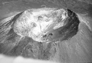 This 400-m-wide crater is at the summit of the cone that formed within the caldera at the summit of Chachadake on the NE tip of Kunashir Island. The SE part of the crater rim (upper right) is the highest point, seen here in October 1990.
 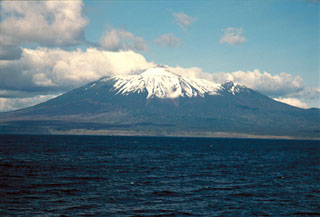 The SE flanks of Chachadake volcano in the Kuril Islands rise above the Pacific Ocean at the NE tip of Kunashir Island. A cone has formed in the 2.1 x 2.4 km summit caldera and is seen here rising above the center of the edifice. A major explosive eruption in 1973 and a smaller eruption occurred in 1812.
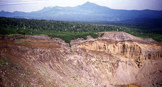 Ruruidake is composed of the cone on the horizon and the gently sloping Smirnov to the left. It is located at the NW tip of Kunashir Island. Smirnov has been extensively eroded by glaciers and contains young pyroclastic flow deposits and lava domes. The late-Pleistocene volcano has an active fumarole field on its western flank. The crater in the foreground is the northern crater of the 1973 eruption of Chachadake volcano to the SE.
 The maps shown below have been scanned from the GVP map archives and include the volcano on this page. Clicking on the small images will load the full 300 dpi map. Very small-scale maps (such as world maps) are not included. The maps database originated over 30 years ago, but was only recently updated and connected to our main database. We welcome users to tell us if they see incorrect information or other problems with the maps; please use the Contact GVP link at the bottom of the page to send us email.
There are no samples for Chachadake [Tiatia] in the Smithsonian's NMNH Department of Mineral Sciences Rock and Ore collection.
| Copernicus Browser | The Copernicus Browser replaced the Sentinel Hub Playground browser in 2023, to provide access to Earth observation archives from the Copernicus Data Space Ecosystem, the main distribution platform for data from the EU Copernicus missions. |
| MIROVA | Middle InfraRed Observation of Volcanic Activity (MIROVA) is a near real time volcanic hot-spot detection system based on the analysis of MODIS (Moderate Resolution Imaging Spectroradiometer) data. In particular, MIROVA uses the Middle InfraRed Radiation (MIR), measured over target volcanoes, in order to detect, locate and measure the heat radiation sourced from volcanic activity. |
| MODVOLC Thermal Alerts | Using infrared satellite Moderate Resolution Imaging Spectroradiometer (MODIS) data, scientists at the Hawai'i Institute of Geophysics and Planetology, University of Hawai'i, developed an automated system called MODVOLC to map thermal hot-spots in near real time. For each MODIS image, the algorithm automatically scans each 1 km pixel within it to check for high-temperature hot-spots. When one is found the date, time, location, and intensity are recorded. MODIS looks at every square km of the Earth every 48 hours, once during the day and once during the night, and the presence of two MODIS sensors in space allows at least four hot-spot observations every two days. Each day updated global maps are compiled to display the locations of all hot spots detected in the previous 24 hours. There is a drop-down list with volcano names which allow users to 'zoom-in' and examine the distribution of hot-spots at a variety of spatial scales. |
|
WOVOdat
Single Volcano View Temporal Evolution of Unrest Side by Side Volcanoes |
WOVOdat is a database of volcanic unrest; instrumentally and visually recorded changes in seismicity, ground deformation, gas emission, and other parameters from their normal baselines. It is sponsored by the World Organization of Volcano Observatories (WOVO) and presently hosted at the Earth Observatory of Singapore.
GVMID Data on Volcano Monitoring Infrastructure The Global Volcano Monitoring Infrastructure Database GVMID, is aimed at documenting and improving capabilities of volcano monitoring from the ground and space. GVMID should provide a snapshot and baseline view of the techniques and instrumentation that are in place at various volcanoes, which can be use by volcano observatories as reference to setup new monitoring system or improving networks at a specific volcano. These data will allow identification of what monitoring gaps exist, which can be then targeted by remote sensing infrastructure and future instrument deployments. |
| Volcanic Hazard Maps | The IAVCEI Commission on Volcanic Hazards and Risk has a Volcanic Hazard Maps database designed to serve as a resource for hazard mappers (or other interested parties) to explore how common issues in hazard map development have been addressed at different volcanoes, in different countries, for different hazards, and for different intended audiences. In addition to the comprehensive, searchable Volcanic Hazard Maps Database, this website contains information about diversity of volcanic hazard maps, illustrated using examples from the database. This site is for educational purposes related to volcanic hazard maps. Hazard maps found on this website should not be used for emergency purposes. For the most recent, official hazard map for a particular volcano, please seek out the proper institutional authorities on the matter. |
| IRIS seismic stations/networks | Incorporated Research Institutions for Seismology (IRIS) Data Services map showing the location of seismic stations from all available networks (permanent or temporary) within a radius of 0.18° (about 20 km at mid-latitudes) from the given location of Chachadake [Tiatia]. Users can customize a variety of filters and options in the left panel. Note that if there are no stations are known the map will default to show the entire world with a "No data matched request" error notice. |
| UNAVCO GPS/GNSS stations | Geodetic Data Services map from UNAVCO showing the location of GPS/GNSS stations from all available networks (permanent or temporary) within a radius of 20 km from the given location of Chachadake [Tiatia]. Users can customize the data search based on station or network names, location, and time window. Requires Adobe Flash Player. |
| DECADE Data | The DECADE portal, still in the developmental stage, serves as an example of the proposed interoperability between The Smithsonian Institution's Global Volcanism Program, the Mapping Gas Emissions (MaGa) Database, and the EarthChem Geochemical Portal. The Deep Earth Carbon Degassing (DECADE) initiative seeks to use new and established technologies to determine accurate global fluxes of volcanic CO2 to the atmosphere, but installing CO2 monitoring networks on 20 of the world's 150 most actively degassing volcanoes. The group uses related laboratory-based studies (direct gas sampling and analysis, melt inclusions) to provide new data for direct degassing of deep earth carbon to the atmosphere. |
| Large Eruptions of Chachadake [Tiatia] | Information about large Quaternary eruptions (VEI >= 4) is cataloged in the Large Magnitude Explosive Volcanic Eruptions (LaMEVE) database of the Volcano Global Risk Identification and Analysis Project (VOGRIPA). |
| EarthChem | EarthChem develops and maintains databases, software, and services that support the preservation, discovery, access and analysis of geochemical data, and facilitate their integration with the broad array of other available earth science parameters. EarthChem is operated by a joint team of disciplinary scientists, data scientists, data managers and information technology developers who are part of the NSF-funded data facility Integrated Earth Data Applications (IEDA). IEDA is a collaborative effort of EarthChem and the Marine Geoscience Data System (MGDS). |

