
SVERT reported that on 3 April at 0755 ash from Grozny Group fell in Kurilsk (23 km N) and Kitovy, producing deposits 2-3 mm thick. Cloud cover prevented observations of the volcano. The next day satellite images showed an ash plume that rose 3 km (10,000 ft) a.s.l. and drifted W and NW. The Aviation Color Code remained at Yellow.
Source: Sakhalin Volcanic Eruption Response Team (SVERT)
23 years of quiet ended by occasional minor 2012-2013 eruptions
Etorofu-Yakeyama (Ivan Grozny or Grozny Group) rests on E-central Iturup Island (known as Etorofu-to in Japanese and Ostrov Iturup in Russian) (figures 4 and 5). An andesitic lava dome forms the peak, and the complex also includes a ~3-3.5 km long caldera open to the S. The complex erupted multiple times during 1968-1989. Several minor eruptions occurred during 2012 and 2013. Our previous report (BGVN 17:12) described a 3 May 1989 eruption. The Japan Meteorological Agency (JMA), the Tokyo Volcano Ash Advisory Center (VAAC), and the Sakhalin Volcanic Eruption Response Team (SVERT) were primary sources for this report discussing events as late as April 2013 with no further notice of eruptions through July 2014.
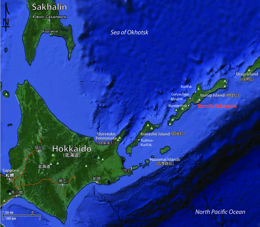 |
Figure 4. Etorofu-Yakeyama on Iturup Island and the regional area including Hokkaido, Japan (more than 200 km SW) and Sakhalin, Russia (more than 350 km NW). Three settlements on Iturup Island are noted here: Kuril'sk, Goyachiye Klyuchi, and Burevestnik. Green triangles indicate volcanic centers. Annotated GoogleMap image. |
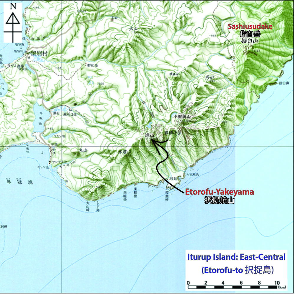 |
Figure 5. Etorofu-Yakeyama located on a topographic map (100 m contour lines). Etorofu-Yakeyama sits ~6 km from the Pacific Ocean shore and ~14 km SW of the stratovolcano Sashiusudake (also known as Baransky). Map published by the Geospatial Information Authority of Japan and annotated with placenames from JMA reports. |
2012 eruptions. According to SVERT, Etorofu-Yakeyama erupted on 16 August 2012, for the first time since 1989. The plume from the lava dome inside the caldera resulted in light ashfall in the Goryachiye and Kuril`sk settlements (to the N; figure 4). JMA reported the eruption started on 15 August and ended on 26 August 2012 as noted in table 1. Based on MTSAT-2 satellite images, JMA noted an ash plume reached 4 km altitude on 25 August. The Tokyo VAAC issued a Volcanic Ash Advisory (VAA) on 25 August. No additional ash observations were issued after 25 August 2012.
Table 2. A synopsis of eruptions that took place at Etorofu-Yakeyama during 1968-2012. Taken from the JMA website.
| Year | Phenomenon | Activity, damage, etc. |
| 1968 | Eruption | February 1968. |
| 1970 | Eruption | -- |
| 1973 | Eruption Explosion |
Small explosion at summit crater in early January. Series of strong explosions at summit crater on 16 May and formation of a large crater. |
| 1989 | Explosion | Explosions during 3-14 May, 19 June, and early August with a volcanic plume 2 km high. |
| 2012 | Eruption | Eruption during 15-26 August with a plume 4-5 km high. |
On 16 August 2012, F. Greenberg, a Sakhalin Region Emergency Ministry representative, reported that gas emissions on the NE slope had increased on 14 August which suggested unrest. Hokkaido University researchers associated with JMA visited Etorofu-to Island and reported eruptive activity started on 15 August.
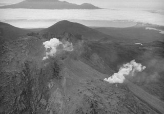
Four eruptions occurred during 25-26 August. One plume rose 4-5 km. Figure 6 shows the volcano erupting on 25 August 2012. The next day in the same general area the researchers reported fumarolic activity on the NE side where the ash plume vented (figure 7). SVERT reported during 23 August-3 September increased fumarolic activity at Etorofu-Yakeyama. The Aviation Color code during that interval was Yellow.
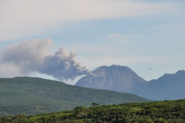 |
Figure 7. Etorofu-Yakeyama seen during an eruption as viewed from NW on 25 August 2012. Courtesy of JMA and Hokkaido University. Photo by M. Nakagawa. |
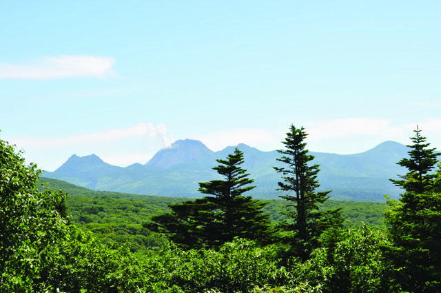 |
Figure 8. Etorofu-Yakeyama during fumarolic activity viewed from N on 26 August 2012. The double peaked dome to the left of the active Yakeyama/Grozny dome is called Eboshizan. Courtesy of JMA and Hokkaido University. Photo by M. Nakagawa. |
2013 eruptions. Ash fall was reported several times during February-April 2013. SVERT reported that on 16 February, a gas and ash plume rose to an altitude of about 3 km. Tokyo VAAC reported a possible eruption occurred on 29 March. The possible ash plume rose to 2.1 km and drifted E.
On 3 April 2013 an eruption took place that was later reported by Interfax, Russia & FSU General News. 2-3 mm of ash was deposited on Kuril`sk and other settlements. Plume height was not recorded due to cloud cover in the area. On 4 April, the Tokyo VAAC detected an ash plume with an altitude of ~3 km drifting W and NW in satellite images. No additional ash observations were issued after 4 April 2013.
Information Contacts: Japan Meteorological Agency (JMA), Otemachi, 1-3-4, Chiyoda-ku Tokyo 100-8122, Japan (URL: http://www.jma.go.jp/); Tokyo Volcanic Ash Advisory Center (Tokyo VAAC) (URL: https://ds.data.jma.go.jp/svd/vaac/data/); Sakhalin Volcanic Eruption Response Team (SVERT) (URL: http://www.imgg.ru/en/svert.html); EMERCOM Crisis Management Centre (URL: http://en.mchs.ru/Forces_and_Facilities/National_Emergency_Management_Centre); Sakhalin Institute of Marine Geology and Geophysics Institute of Marine Geology and Geophysics FEB RAS (IMGG FEB RAS), 693022, Russia, Yuzhno-Sakhalinsk, Nauki str. 1B (URL: http://www.imgg.ru/); RIA Novosti (URL: http://en.rian.ru/); Itar-Tass (URL: http://tass.ru); and Interfax, Russia, & FSU General News (URL: http://connection.ebscohost.com).
2013: February
| March
| April
2012: August
| September
SVERT reported that on 3 April at 0755 ash from Grozny Group fell in Kurilsk (23 km N) and Kitovy, producing deposits 2-3 mm thick. Cloud cover prevented observations of the volcano. The next day satellite images showed an ash plume that rose 3 km (10,000 ft) a.s.l. and drifted W and NW. The Aviation Color Code remained at Yellow.
Source: Sakhalin Volcanic Eruption Response Team (SVERT)
Based on analysis of satellite images, the Tokyo VAAC reported that on 30 March a possible eruption from Grozny Group may have produced a plume that rose 2.1 km (7,000 ft) a.s.l. and drifted E. A later VAAC notice stated that ash had dissipated.
Source: Tokyo Volcanic Ash Advisory Center (VAAC)
Based on visual observations, SVERT reported that on 16 February an ash-and-gas plume from Grozny Group rose 3 km a.s.l. The Aviation Color Code was raised to Yellow.
Source: Sakhalin Volcanic Eruption Response Team (SVERT)
Based on visual observations and analyses of satellite imagery, SVERT reported that during 10-17 September fumarolic activity at Grozny Group was at a medium intensity. The Aviation Color Code was lowered to Green.
Source: Sakhalin Volcanic Eruption Response Team (SVERT)
Based on visual observations and analyses of satellite imagery, SVERT reported that during 4-10 September fumarolic activity at Grozny Group increased. The Aviation Color Code remained at Yellow.
Source: Sakhalin Volcanic Eruption Response Team (SVERT)
Based on visual observations and analyses of satellite imagery, SVERT reported that during 23 August-3 September fumarolic activity at Grozny Group increased. The Aviation Color Code remained at Yellow.
Source: Sakhalin Volcanic Eruption Response Team (SVERT)
Based on analyses of satellite imagery, SVERT reported that on 22 August a gas-and-ash plume rose 500 m above Grozny Group and drifted 15 km NE. Fumarolic activity increased during 23-25 August. Observers reported that an ash plume rose to 5 km (16,400 ft) a.s.l. on 25 August. That same day the Tokyo VAAC reported that a possible eruption from Etorofu-Yake-yama, a lava dome of the Grozny Group, may have produced a plume that rose to an altitude of 4 km (13,000 ft) a.s.l. and drifted E.
Sources: Sakhalin Volcanic Eruption Response Team (SVERT); Tokyo Volcanic Ash Advisory Center (VAAC)
According to news reports, Ivan Grozny, one of two volcanoes comprising the Grozny Group, erupted on 16 August, after increased gas emissions from the NE flank were observed the day before. An ash plume rose 1.2 km and caused ashfall in Goryachiye Klyuchi (9 km W) and Kurilsk (25 km away). Residents reported a sulfur dioxide odor. By the afternoon ashfall had ceased and the odor subsided.
Sources: RIA Novosti; Itar-Tass News
Reports are organized chronologically and indexed below by Month/Year (Publication Volume:Number), and include a one-line summary. Click on the index link or scroll down to read the reports.
Single weak explosion
Card 1684 (27 July 1973) Single weak explosion
. . . at the beginning of the year there was a single weak explosion from the volcano "Ivan Grozny" on the island of Iturup.
Information Contacts: Y.M. Doubik, IV.
Ash eruption; earthquakes and tremor
An abrupt increase in white fumarolic emissions, accompanied by weak explosions of gas and black ash, was observed . . . 3-4 May. A seismograph in Kurilsk (~30 km from the volcano) recorded weak earthquakes at various depths and short-period volcanic tremor for the following 5 days [see also 15:2]. On 8 May at 1330, a strong explosion ejected a black ash column that reached 1,500-1600 m above the summit within 8 minutes. By 1402, winds were dispersing the plume. A low-frequency rumble was heard in Kurilsk and Goryachie Kluchi (9 km W) during the eruption, but witnesses on the Pacific coast (6-8 km S) heard no sounds. On 11 May, images from a NOAA polar orbiting satellite at 1400 and Japan's GMS satellite at 1900 showed no volcanic plume. Small ash explosions occurred after 14 May, and as of 26 May, steam/gas emissions were continuing. More than a week before the eruption, a report in the 25 April Sovetskii Sakhalin newspaper warned that the residents of Goryachie Kluchi village would be at risk if an explosion should occur.
Before the eruption, fumarolic activity was concentrated in the N block along a wide fracture that extended 250-300 m down the W slope from the summit. Geologists who flew over the volcano in a helicopter and airplane 10 days after the eruption (on 18 and 20 May) observed a narrow mudflow, ~20-30 m wide and 1 km long, on the E slope. Fumarolic activity was still visible in the upper portion of the N block fracture. Fumaroles were also observed in the saddle separating the blocks of the dome, near the E slope.
Further Reference. Abdurakhmanov, A.I., Zlobin, T.K., Markhinin, E.K., and Tarakanov, R.Z., 1990, The Ivan Groznyi volcano eruption on the Iturup Island in 1989: Volcanology and Seismology, no. 4, p. 3-9 (in Russian); v. 12, p. 423-430 (in English).
Information Contacts: G. Steinberg, V. Ostapenko, and R. Bulgakov, Yuzhno-Sakhalinsk; G. Bogoyavlenskaya and I. Menyailov, IV; T. Baldwin, NOAA/NESDIS.
Small explosions form new fumaroles; mudflows
After an increase in fumarolic emissions and weak ash explosions in May, fumarolic activity remained vigorous. An eruption on 19 June at 2230, accompanied by 2-3 minutes of weak rumbling, sent ash and gas to ~2 km. An early August explosion formed new fumarolic vents on the dome's N flank, ~70-100 m from the summit (figure 1).
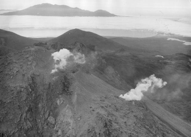 |
Figure 1. September 1989 photograph by A. Samoluk, looking W at the new fumaroles formed by an August explosion on the dome's N side. |
On a 16 September ascent of the dome, geologists G. Steinberg and S Tkachenko observed vigorous gas emission from several sulfur-encrusted fissures, and deep narrow craters ~2-3 m in diameter. Two mud flows (4-6 m wide) that extended 1.5-2 km down the dome's N side had destroyed areas of thick vegetation (bushes and bamboo). One flow reached Lake Lopastnye (figure 2). No juvenile material was found in the flows. A small mudflow deposit on the S side of the dome, and another on the W (previously seen 18 and 20 May; reported as E slope in 14:5) were also observed.
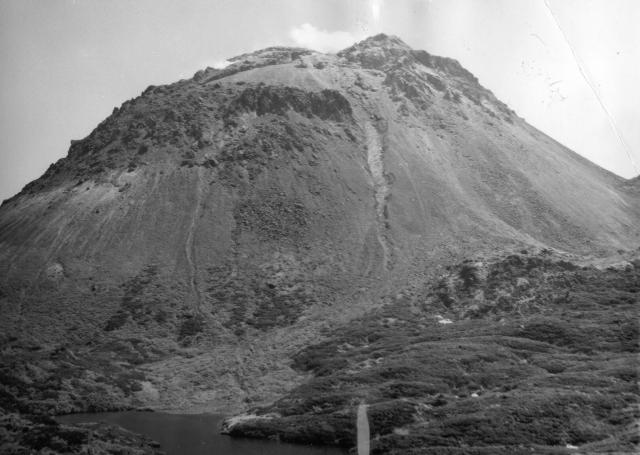 |
Figure 2. September 1989 photograph by A. Samoluk, looking S at two mudflows on the dome's N side. Lake Lopastnye is in the foreground. |
Information Contacts: G. Steinberg and R. Bulgakov, Yuzhno-Sakhalinsk.
New fumaroles formed after predicted ash eruption in June
After the May 1989 activity, geologists performed aerial and field investigations at the request of local authorities. They forecast that vigorous fumarolic activity and rare weak explosions would continue through August, and this assessment was printed in the regional newspaper Suvorovsky Natisc on 15 June 1989, 4 days before the June eruption. Moderate fumarolic activity continued in June.
Seismic activity in a 100-m-wide zone extending NE across the volcano had increased March-May 1989. According to R.Z. Tarakanov, the earthquakes were at 30 and 60 km depths.
Aerial observations in August revealed a new group of fumaroles in the NNE part of the dome. During their 16 September ascent of the dome, Steinberg and Tkachenko measured gas temperatures of 100-104°C. Deep, narrow, craters had formed at the intersections of en-echelon fissures, and the surface around them was covered by andesitic ash (table 1). It is not yet known if the material was juvenile.
Table 1. Chemical analyses of ash samples collected from fissures in Ivan Grozny's summit dome. Analytical values are volume percent of dry gas. Courtesy of G. Steinberg.
| Measurement | Sample 9 | Sample 10 |
| Temp. (°C) | 220 | 160 |
| H2O (mole %) | 92.2 | 96.6 |
| CO2 | 83.36 | 49.88 |
| H2S | 12.63 | 21.85 |
| SO2 | 2.45 | 2.40 |
| H2 | 1.82 | 18.75 |
| CO | -- | -- |
| HCl | 0.73 | 7.02 |
| HF | 0.01 | 0.11 |
| CH4 | 0 | 0 |
Fumarolic activity was distributed along the summit crater fissure. Before the May explosions, emissions had been observed over the entire cross-section of the crater's fissure and on the E slope of the dome. No fumarolic activity was observed in August on the E outer slope of the dome, only from its uppermost W portion. The floor of the E part of the crater was covered with 30 cm of ash but exhibited no fumarolic activity.
At the request of the local authorities, geologists forecast (and published in the local newspaper Krasny Mayak on 28 September) that the volcano's activity should continue at its present level through February 1990.
Information Contacts: G. Steinberg and R. Bulgakov, Yuzhno-Sakhalinsk.
Additional details about 1989 eruption
The following description of the 1989 eruption includes information supplementing 14:5 and 14:12. The eruption began on 3 May, as gas emission became more intense in the trench at the central dome's summit and on the dome's NE flank. Ash rose to ~1.5 km above the summit on 8 May. Weaker ash eruptions took place 9-13 May, and lahars were triggered by intense snowmelt. The E lahar moved >600 m down the dome, spreading at its base to form a lithic-rich deposit ~200 m across. Other lahars, no wider than 3-5 m, flowed N toward Lake Lopastnoye (figure 3), destroying dense stands of bamboo; one lahar entered the lake. After the May eruption, gas emission was concentrated in the summit fissure, and gas was no longer emerging from fissures on the dome's NE flank.
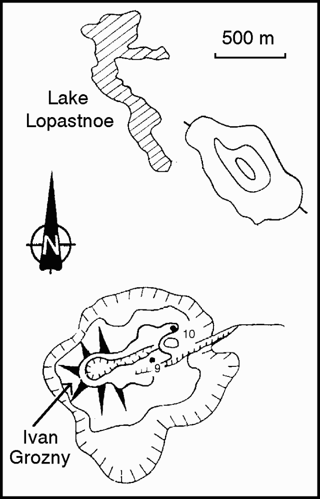 |
Figure 3. Sketch map of Ivan Grozny, showing 1990 gas-sampling sites. Courtesy of G. Steinberg. |
Small ash eruptions occurred again on 19 May and during the first 10 days of August. After the August activity, a new zone of fumaroles was observed on the NE part of the dome, 40-50 m below the fissure's N edge. Fissures 2-3 m wide and funnel-shaped vents 4-5 m in diameter that had ejected ash had formed on the NE part of the dome. S and Cl-rich water vapor was emitted vigorously from the new vents and fissures. Gas emission had nearly stopped from the E end of the summit fissure, where its floor was flat and covered with cooled ash. No juvenile material was found in the 1989 tephra.
Information Contacts: G. Steinberg, Yuzhno-Sakhalinsk.
23 years of quiet ended by occasional minor 2012-2013 eruptions
Etorofu-Yakeyama (Ivan Grozny or Grozny Group) rests on E-central Iturup Island (known as Etorofu-to in Japanese and Ostrov Iturup in Russian) (figures 4 and 5). An andesitic lava dome forms the peak, and the complex also includes a ~3-3.5 km long caldera open to the S. The complex erupted multiple times during 1968-1989. Several minor eruptions occurred during 2012 and 2013. Our previous report (BGVN 17:12) described a 3 May 1989 eruption. The Japan Meteorological Agency (JMA), the Tokyo Volcano Ash Advisory Center (VAAC), and the Sakhalin Volcanic Eruption Response Team (SVERT) were primary sources for this report discussing events as late as April 2013 with no further notice of eruptions through July 2014.
|
Figure 4. Etorofu-Yakeyama on Iturup Island and the regional area including Hokkaido, Japan (more than 200 km SW) and Sakhalin, Russia (more than 350 km NW). Three settlements on Iturup Island are noted here: Kuril'sk, Goyachiye Klyuchi, and Burevestnik. Green triangles indicate volcanic centers. Annotated GoogleMap image. |
|
Figure 5. Etorofu-Yakeyama located on a topographic map (100 m contour lines). Etorofu-Yakeyama sits ~6 km from the Pacific Ocean shore and ~14 km SW of the stratovolcano Sashiusudake (also known as Baransky). Map published by the Geospatial Information Authority of Japan and annotated with placenames from JMA reports. |
2012 eruptions. According to SVERT, Etorofu-Yakeyama erupted on 16 August 2012, for the first time since 1989. The plume from the lava dome inside the caldera resulted in light ashfall in the Goryachiye and Kuril`sk settlements (to the N; figure 4). JMA reported the eruption started on 15 August and ended on 26 August 2012 as noted in table 1. Based on MTSAT-2 satellite images, JMA noted an ash plume reached 4 km altitude on 25 August. The Tokyo VAAC issued a Volcanic Ash Advisory (VAA) on 25 August. No additional ash observations were issued after 25 August 2012.
Table 2. A synopsis of eruptions that took place at Etorofu-Yakeyama during 1968-2012. Taken from the JMA website.
| Year | Phenomenon | Activity, damage, etc. |
| 1968 | Eruption | February 1968. |
| 1970 | Eruption | -- |
| 1973 | Eruption Explosion |
Small explosion at summit crater in early January. Series of strong explosions at summit crater on 16 May and formation of a large crater. |
| 1989 | Explosion | Explosions during 3-14 May, 19 June, and early August with a volcanic plume 2 km high. |
| 2012 | Eruption | Eruption during 15-26 August with a plume 4-5 km high. |
On 16 August 2012, F. Greenberg, a Sakhalin Region Emergency Ministry representative, reported that gas emissions on the NE slope had increased on 14 August which suggested unrest. Hokkaido University researchers associated with JMA visited Etorofu-to Island and reported eruptive activity started on 15 August.
Four eruptions occurred during 25-26 August. One plume rose 4-5 km. Figure 6 shows the volcano erupting on 25 August 2012. The next day in the same general area the researchers reported fumarolic activity on the NE side where the ash plume vented (figure 7). SVERT reported during 23 August-3 September increased fumarolic activity at Etorofu-Yakeyama. The Aviation Color code during that interval was Yellow.
|
Figure 7. Etorofu-Yakeyama seen during an eruption as viewed from NW on 25 August 2012. Courtesy of JMA and Hokkaido University. Photo by M. Nakagawa. |
|
Figure 8. Etorofu-Yakeyama during fumarolic activity viewed from N on 26 August 2012. The double peaked dome to the left of the active Yakeyama/Grozny dome is called Eboshizan. Courtesy of JMA and Hokkaido University. Photo by M. Nakagawa. |
2013 eruptions. Ash fall was reported several times during February-April 2013. SVERT reported that on 16 February, a gas and ash plume rose to an altitude of about 3 km. Tokyo VAAC reported a possible eruption occurred on 29 March. The possible ash plume rose to 2.1 km and drifted E.
On 3 April 2013 an eruption took place that was later reported by Interfax, Russia & FSU General News. 2-3 mm of ash was deposited on Kuril`sk and other settlements. Plume height was not recorded due to cloud cover in the area. On 4 April, the Tokyo VAAC detected an ash plume with an altitude of ~3 km drifting W and NW in satellite images. No additional ash observations were issued after 4 April 2013.
Information Contacts: Japan Meteorological Agency (JMA), Otemachi, 1-3-4, Chiyoda-ku Tokyo 100-8122, Japan (URL: http://www.jma.go.jp/); Tokyo Volcanic Ash Advisory Center (Tokyo VAAC) (URL: https://ds.data.jma.go.jp/svd/vaac/data/); Sakhalin Volcanic Eruption Response Team (SVERT) (URL: http://www.imgg.ru/en/svert.html); EMERCOM Crisis Management Centre (URL: http://en.mchs.ru/Forces_and_Facilities/National_Emergency_Management_Centre); Sakhalin Institute of Marine Geology and Geophysics Institute of Marine Geology and Geophysics FEB RAS (IMGG FEB RAS), 693022, Russia, Yuzhno-Sakhalinsk, Nauki str. 1B (URL: http://www.imgg.ru/); RIA Novosti (URL: http://en.rian.ru/); Itar-Tass (URL: http://tass.ru); and Interfax, Russia, & FSU General News (URL: http://connection.ebscohost.com).
This compilation of synonyms and subsidiary features may not be comprehensive. Features are organized into four major categories: Cones, Craters, Domes, and Thermal Features. Synonyms of features appear indented below the primary name. In some cases additional feature type, elevation, or location details are provided.
Synonyms |
||||
| Sio Tsirarippu | Sho-Chirippu | Etorofu-Yake-yama | Ivan Grozny | Kochirippusan | ||||
Cones |
||||
| Feature Name | Feature Type | Elevation | Latitude | Longitude |
| Malysh | Cone | |||
| Motonupuri | Cone | |||
| Rebunshiri | Cone | |||
Domes |
||||
| Feature Name | Feature Type | Elevation | Latitude | Longitude |
| Drakon | Dome | |||
| Eboshizan | Dome | 967 m | 45° 0' 59" N | 147° 53' 18" E |
| Ermak | Dome | |||
|
Grozny
Yakeyama |
Dome | 1133 m | 45° 0' 39" N | 147° 52' 23" E |
|
|
||||||||||||||||||||||||
There is data available for 7 confirmed Holocene eruptive periods.
2013 Feb 16 - 2013 Apr 4 Confirmed Eruption Max VEI: 2
| Episode 1 | Eruption Episode | Etorofu-Yake-yama / Ivan Grozny | ||||||||||||||||||||||||||||||||||
|---|---|---|---|---|---|---|---|---|---|---|---|---|---|---|---|---|---|---|---|---|---|---|---|---|---|---|---|---|---|---|---|---|---|---|---|
| 2013 Feb 16 - 2013 Apr 4 | Evidence from Observations: Reported | ||||||||||||||||||||||||||||||||||
|
List of 5 Events for Episode 1 at Etorofu-Yake-yama / Ivan Grozny
| |||||||||||||||||||||||||||||||||||
2012 Aug 16 - 2012 Aug 25 Confirmed Eruption Max VEI: 2
| Episode 1 | Eruption Episode | Etorofu-Yake-yama / Ivan Grozny | ||||||||||||||||||||||||||||||||||||||||||||
|---|---|---|---|---|---|---|---|---|---|---|---|---|---|---|---|---|---|---|---|---|---|---|---|---|---|---|---|---|---|---|---|---|---|---|---|---|---|---|---|---|---|---|---|---|---|
| 2012 Aug 16 - 2012 Aug 25 | Evidence from Observations: Reported | ||||||||||||||||||||||||||||||||||||||||||||
|
List of 7 Events for Episode 1 at Etorofu-Yake-yama / Ivan Grozny
| |||||||||||||||||||||||||||||||||||||||||||||
1989 May 3 - 1989 Aug 5 ± 4 days Confirmed Eruption Max VEI: 2
| Episode 1 | Eruption Episode | Ivan Grozny | |||||||||||||||||||||||||||||||||||||||
|---|---|---|---|---|---|---|---|---|---|---|---|---|---|---|---|---|---|---|---|---|---|---|---|---|---|---|---|---|---|---|---|---|---|---|---|---|---|---|---|---|
| 1989 May 3 - 1989 Aug 5 ± 4 days | Evidence from Observations: Reported | |||||||||||||||||||||||||||||||||||||||
|
List of 6 Events for Episode 1 at Ivan Grozny
| ||||||||||||||||||||||||||||||||||||||||
1973 May 16 - 1973 May 17 Confirmed Eruption Max VEI: 2 (?)
| Episode 1 | Eruption Episode | Ivan Grozny (N flank of cent. dome) | |||||||||||||||||||||||||||||||||||||||
|---|---|---|---|---|---|---|---|---|---|---|---|---|---|---|---|---|---|---|---|---|---|---|---|---|---|---|---|---|---|---|---|---|---|---|---|---|---|---|---|---|
| 1973 May 16 - 1973 May 17 | Evidence from Observations: Reported | |||||||||||||||||||||||||||||||||||||||
|
List of 6 Events for Episode 1 at Ivan Grozny (N flank of cent. dome)
| ||||||||||||||||||||||||||||||||||||||||
1973 Jan 16 ± 15 days - 1973 Jan 16 ± 15 days Confirmed Eruption Max VEI: 1
| Episode 1 | Eruption Episode | Ivan Grozny | |||||||||||||||||||
|---|---|---|---|---|---|---|---|---|---|---|---|---|---|---|---|---|---|---|---|---|
| 1973 Jan 16 ± 15 days - 1973 Jan 16 ± 15 days | Evidence from Observations: Reported | |||||||||||||||||||
|
List of 2 Events for Episode 1 at Ivan Grozny
| ||||||||||||||||||||
1970 Jul 2 ± 182 days Confirmed Eruption Max VEI: 1
| Episode 1 | Eruption Episode | Ivan Grozny | ||||||||||||||||||||||||
|---|---|---|---|---|---|---|---|---|---|---|---|---|---|---|---|---|---|---|---|---|---|---|---|---|---|
| 1970 Jul 2 ± 182 days - Unknown | Evidence from Observations: Reported | ||||||||||||||||||||||||
|
List of 3 Events for Episode 1 at Ivan Grozny
| |||||||||||||||||||||||||
1968 Feb 16 ± 15 days - 1968 Feb 16 ± 15 days Confirmed Eruption Max VEI: 1
| Episode 1 | Eruption Episode | Ivan Grozny | ||||||||||||||||||||||||
|---|---|---|---|---|---|---|---|---|---|---|---|---|---|---|---|---|---|---|---|---|---|---|---|---|---|
| 1968 Feb 16 ± 15 days - 1968 Feb 16 ± 15 days | Evidence from Observations: Reported | ||||||||||||||||||||||||
|
List of 3 Events for Episode 1 at Ivan Grozny
| |||||||||||||||||||||||||
There is no Deformation History data available for Etorofu-Yakeyama [Grozny Group].
There is no Emissions History data available for Etorofu-Yakeyama [Grozny Group].
 The Etorofu-Yakeyama (Ivan Grozny) volcano group in central Iturup Island contains the historically active Yakeyama (Grozny) andesitic lava dome and several other Holocene domes to the NE. This September 1989 view from the E shows geothermal emissions that began at the time of a minor 1989 eruption on the N flank of the active dome.
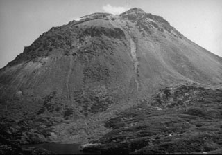 The Yakeyama (Grozny) lava dome, seen here from the N with Lake Lopastnye at the lower left, is the largest dome of the Etorofu-Yakeyama volcanic complex. The two thin light-colored areas descending from the summit region in this September 1989 view mark the paths of small lahars from a minor eruption that began in May 1989. The left-hand lahar reached the lake. The dark-colored area at the lower right is part of a series of lava flows that extend from beneath the dome's debris fan. The largest of these, on the S flank, reached 6 km to the sea.
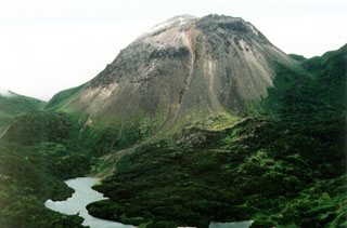 The Yakeyama (Grozny) andesitic lava dome is seen from the N with lava flows descending into Lopasnoye lake in the foreground. The Etorofu-Yakeyama (Ivan Grozny) volcano group in central Iturup Island includes multiple Holocene lava domes.
The maps shown below have been scanned from the GVP map archives and include the volcano on this page. Clicking on the small images will load the full 300 dpi map. Very small-scale maps (such as world maps) are not included. The maps database originated over 30 years ago, but was only recently updated and connected to our main database. We welcome users to tell us if they see incorrect information or other problems with the maps; please use the Contact GVP link at the bottom of the page to send us email.
There are no samples for Etorofu-Yakeyama [Grozny Group] in the Smithsonian's NMNH Department of Mineral Sciences Rock and Ore collection.
| Copernicus Browser | The Copernicus Browser replaced the Sentinel Hub Playground browser in 2023, to provide access to Earth observation archives from the Copernicus Data Space Ecosystem, the main distribution platform for data from the EU Copernicus missions. |
| MIROVA | Middle InfraRed Observation of Volcanic Activity (MIROVA) is a near real time volcanic hot-spot detection system based on the analysis of MODIS (Moderate Resolution Imaging Spectroradiometer) data. In particular, MIROVA uses the Middle InfraRed Radiation (MIR), measured over target volcanoes, in order to detect, locate and measure the heat radiation sourced from volcanic activity. |
| MODVOLC Thermal Alerts | Using infrared satellite Moderate Resolution Imaging Spectroradiometer (MODIS) data, scientists at the Hawai'i Institute of Geophysics and Planetology, University of Hawai'i, developed an automated system called MODVOLC to map thermal hot-spots in near real time. For each MODIS image, the algorithm automatically scans each 1 km pixel within it to check for high-temperature hot-spots. When one is found the date, time, location, and intensity are recorded. MODIS looks at every square km of the Earth every 48 hours, once during the day and once during the night, and the presence of two MODIS sensors in space allows at least four hot-spot observations every two days. Each day updated global maps are compiled to display the locations of all hot spots detected in the previous 24 hours. There is a drop-down list with volcano names which allow users to 'zoom-in' and examine the distribution of hot-spots at a variety of spatial scales. |
|
WOVOdat
Single Volcano View Temporal Evolution of Unrest Side by Side Volcanoes |
WOVOdat is a database of volcanic unrest; instrumentally and visually recorded changes in seismicity, ground deformation, gas emission, and other parameters from their normal baselines. It is sponsored by the World Organization of Volcano Observatories (WOVO) and presently hosted at the Earth Observatory of Singapore.
GVMID Data on Volcano Monitoring Infrastructure The Global Volcano Monitoring Infrastructure Database GVMID, is aimed at documenting and improving capabilities of volcano monitoring from the ground and space. GVMID should provide a snapshot and baseline view of the techniques and instrumentation that are in place at various volcanoes, which can be use by volcano observatories as reference to setup new monitoring system or improving networks at a specific volcano. These data will allow identification of what monitoring gaps exist, which can be then targeted by remote sensing infrastructure and future instrument deployments. |
| Volcanic Hazard Maps | The IAVCEI Commission on Volcanic Hazards and Risk has a Volcanic Hazard Maps database designed to serve as a resource for hazard mappers (or other interested parties) to explore how common issues in hazard map development have been addressed at different volcanoes, in different countries, for different hazards, and for different intended audiences. In addition to the comprehensive, searchable Volcanic Hazard Maps Database, this website contains information about diversity of volcanic hazard maps, illustrated using examples from the database. This site is for educational purposes related to volcanic hazard maps. Hazard maps found on this website should not be used for emergency purposes. For the most recent, official hazard map for a particular volcano, please seek out the proper institutional authorities on the matter. |
| IRIS seismic stations/networks | Incorporated Research Institutions for Seismology (IRIS) Data Services map showing the location of seismic stations from all available networks (permanent or temporary) within a radius of 0.18° (about 20 km at mid-latitudes) from the given location of Etorofu-Yakeyama [Grozny Group]. Users can customize a variety of filters and options in the left panel. Note that if there are no stations are known the map will default to show the entire world with a "No data matched request" error notice. |
| UNAVCO GPS/GNSS stations | Geodetic Data Services map from UNAVCO showing the location of GPS/GNSS stations from all available networks (permanent or temporary) within a radius of 20 km from the given location of Etorofu-Yakeyama [Grozny Group]. Users can customize the data search based on station or network names, location, and time window. Requires Adobe Flash Player. |
| DECADE Data | The DECADE portal, still in the developmental stage, serves as an example of the proposed interoperability between The Smithsonian Institution's Global Volcanism Program, the Mapping Gas Emissions (MaGa) Database, and the EarthChem Geochemical Portal. The Deep Earth Carbon Degassing (DECADE) initiative seeks to use new and established technologies to determine accurate global fluxes of volcanic CO2 to the atmosphere, but installing CO2 monitoring networks on 20 of the world's 150 most actively degassing volcanoes. The group uses related laboratory-based studies (direct gas sampling and analysis, melt inclusions) to provide new data for direct degassing of deep earth carbon to the atmosphere. |
| Large Eruptions of Etorofu-Yakeyama [Grozny Group] | Information about large Quaternary eruptions (VEI >= 4) is cataloged in the Large Magnitude Explosive Volcanic Eruptions (LaMEVE) database of the Volcano Global Risk Identification and Analysis Project (VOGRIPA). |
| EarthChem | EarthChem develops and maintains databases, software, and services that support the preservation, discovery, access and analysis of geochemical data, and facilitate their integration with the broad array of other available earth science parameters. EarthChem is operated by a joint team of disciplinary scientists, data scientists, data managers and information technology developers who are part of the NSF-funded data facility Integrated Earth Data Applications (IEDA). IEDA is a collaborative effort of EarthChem and the Marine Geoscience Data System (MGDS). |

