The Institute of Volcanology and Geodynamics (Russian Academy of Natural Science) reported that during the morning of 31 July volcanologists working on Kudryavy, a stratovolcano of the Medvezhia volcanic complex, noted a sharp increase in the volume of vapor-and-gas emissions, with a plume rising more than 1 km. The emissions rose from a new crater, Malysh, that was formed after the 1999 phreatic eruption. A significant increase in temperature (an average of 100 degrees Celsius) was measured at fumarolic sites, and new high-temperature areas were noted. Crusts of native sulfur at the boundaries of high-temperature areas were melting and burning. Two people at the top of the volcano and workers at the main base camp (3.5 km S) self-evacuated.
The report noted that a M 5.7 earthquake had occurred at 0800 that same morning, 200 km NE, within the same system of tectonic faults that the volcano resides on. The volcano has a permeable system of fissures, through which there has been constant degassing for more than 130 years.
Source: Institute of Volcanology and Geodynamics, Russian Academy of Natural Science
Small phreatic eruption from the Kudriavy summit forms a new crater
Changes in activity at the Kudriavy cone (figure 2) were detected in mid-September 1999, preceding an eruption on 7 October. Since 1989 the temperatures of sediments in the dry lakes within the crater (lakes temporarily exist after snow melting and strong rains) at a depth of 0.75 m have consistently fallen in the range of 48-82°C, with fluctuations of 3-5°C. In contrast, September 1999 measurements at the control points in the Hot Lake area showed increasing temperatures of 60-102°C. [These temperature measurements have been made 1-3 times each year.]
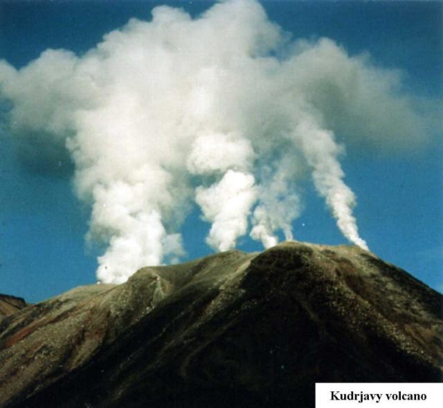 |
Figure 2. Photograph of fumarolic plumes rising from the crater of the Kudriavy cone at Medvezhia, September-October 1999. Courtesy of G.S. Steinberg. |
The weather in August, September, and October was unusually dry for the region, with rain only during 24-25 September and 2-3 October. A temperature survey of two lakes was made in September. Usually, lakes exist 1-2 days after rains, but the water in Hot Lake still covered more than half the area on 4 October. Temperatures in the dry part of the lake had increased by 14-22°C. The lake water close to the hot dome was boiling and seething due to gas emissions. [The hot dome is 150-170 m in diameter, rising 60-70 m above the bottom of Hot Lake to the W and 30-40 m above the bottom of the dry lake to the S.] On 5 October the diameter of the lake was 15 m. That day two channels were excavated to allow the water to drain so that sediment temperatures could be measured. The temperature increase in this newly drained area was more than 30°C. Fumarole gas compositions during the second part of September showed increased hydrogen, oxygen, and fluorine. Sulfur ignition was seen in some locations. The number of earthquakes also increased, and although the one-channel seismic station deployed was insufficient to determine any hypocenters, the elevated seismicity was obvious. District and province authorities were warned three days before the start of the 7 October eruption that Kudriavy was unstable and could erupt soon. [On the evening of 4 October the Governor of Sakhalin and the Mayor of Kurilsk were notified that activity at Kudriavy had rapidly increased and that an eruption was expected to begin during the week of 8-15 October, with possible stronger activity later in the month.]
From the base camp, 3.5 km W from the volcano, black and gray clouds of gas and ash were observed rising above the usual fumarolic plumes at 1735 on 7 October and then extending ~10 km NW. Ejections of gas and ash occurred at intervals of 1-2 minutes. Because of the strong winds, maximum altitude of ejections was 1,100 m. The upper camp was at 940 m elevation, 30-40 m from the crater edge and 300 m from Hot Lake (figure 3). Because of strong winds, bad visibility, and the low-intensity start of the eruption, volcanic tremor and gas-and-ash ejections were not noticed in the upper camp until 10 minutes after observers in the base camp saw the plume. Night observations showed that intense ejections stopped at 0200 on 8 October. Observations through the clouds of the N part of the crater revealed "slight reddish lights - reflected light of the hot rocks and blue lights - light of the burning sulfur" that marked the edges of a crater.
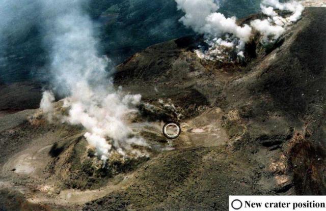 |
Figure 3. Aerial photograph of the N part of the Kudriavy crater at Medvezhia showing the locations of the upper camp and the new explosion crater W of the hot lava dome during 7-8 October 1999. North is to the left. Courtesy of G.S. Steinberg. |
No juvenile ash was identified, so the eruption was determined to be phreatic. This eruption was similar to a geyser eruption: periodic vertical ejection of the gas, ash, and steam. Ejecta didn't fall more than 30-40 m from the new crater. The surface of Hot Lake was covered by rocks with diameters of 20-30 cm, and ashfall deposits were concentrated to the NW. The volume of erupted material was nearly 40,000-45,000 m3. Areas with rhenium mineralization (see BGVN 20:10) located on the dome were not involved in the eruption or covered by eruption products. The first phase of the eruption was over on 13 October.
The eruption created a new crater in the Hot Lake area and removed part of the dome (figure 4). The crater was elliptical with dimensions of 30 x 40 m and a depth 35-40 m from the bottom of the lake and 80-110 m from the flat part of the dome (figure 5). The walls of the crater were vertical. In the lower part of the S crater wall was a 6 x 8 m cave of incandescent rocks. Based on the light intensity, the temperature was estimated to be higher than 1,000-1,100°C. Hot gas rose from this area and condensed 40-60 m above the edge of the crater. Small fiery areas and fragments with burning sulfur were seen on the S, W, and N walls. [Minor explosions continued from the cave until 13 October. Activity then declined, consisting of gas emissions with some small rock fragments that didn't reach the crater rim. No significant changes were noted through 2 November, when observations ended.]
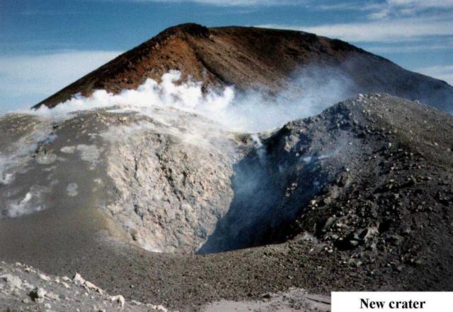 |
Figure 4. Photograph of the hot dome and dry lake area in the N part of the Kudriavy crater at Medvezhia prior to the 7-8 October 1999 eruption. Courtesy of G.S. Steinberg. |
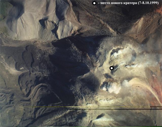 |
Figure 5. Photograph of the 7-8 October 1999 crater adjacent to the hot dome in the N part of the Kudriavy crater at Medvezhia, October 1999. Courtesy of G.S. Steinberg. |
Information Contacts: Genrikh S. Steinberg, Institute of Volcanology and Geodynamics, Russian Academy of Natural Science, Box 18, Yuzhno-Sakhalinsk 693008, Russia.
2017: July
2015: March
2014: November
| December
2013: January
The Institute of Volcanology and Geodynamics (Russian Academy of Natural Science) reported that during the morning of 31 July volcanologists working on Kudryavy, a stratovolcano of the Medvezhia volcanic complex, noted a sharp increase in the volume of vapor-and-gas emissions, with a plume rising more than 1 km. The emissions rose from a new crater, Malysh, that was formed after the 1999 phreatic eruption. A significant increase in temperature (an average of 100 degrees Celsius) was measured at fumarolic sites, and new high-temperature areas were noted. Crusts of native sulfur at the boundaries of high-temperature areas were melting and burning. Two people at the top of the volcano and workers at the main base camp (3.5 km S) self-evacuated.
The report noted that a M 5.7 earthquake had occurred at 0800 that same morning, 200 km NE, within the same system of tectonic faults that the volcano resides on. The volcano has a permeable system of fissures, through which there has been constant degassing for more than 130 years.
Source: Institute of Volcanology and Geodynamics, Russian Academy of Natural Science
SVERT reported that satellite images showed a weak thermal anomaly over Kudryavy, a stratovolcano of the Medvezhia volcanic complex, on 18 March.
Source: Sakhalin Volcanic Eruption Response Team (SVERT)
On 12 December SVERT reported that activity at Kudriavy, a stratovolcano of the Medvezhia volcanic complex, had not increased since 1 December. The Aviation Color Code was lowered to Green.
Source: Sakhalin Volcanic Eruption Response Team (SVERT)
On 27 November SVERT reported that during the previous 10 days a thermal anomaly and strengthening steam-and-gas activity were detected over Kudriavy, a stratovolcano of the Medvezhia volcanic complex. The size and intensity of the thermal anomaly increased considerably on 27 November. The Aviation Color Code was raised to Yellow. Diffuse steam-and-gas emissions were observed on 29 November.
Source: Sakhalin Volcanic Eruption Response Team (SVERT)
SVERT reported that a thermal anomaly was detected over Kudriavy, a stratovolcano of the Medvezhia volcanic complex, on 11 January. Strong steam-and-gas plumes were also observed.
Source: Sakhalin Volcanic Eruption Response Team (SVERT)
Reports are organized chronologically and indexed below by Month/Year (Publication Volume:Number), and include a one-line summary. Click on the index link or scroll down to read the reports.
Intense fumarolic activity from the Kudriavy cone
The 20 September 1981 aerial inspection [of the volcanoes in the S and central Kuril Islands] revealed intense fumarolic activity at five sites in Kudriavy crater.
Information Contacts: G. Steinberg, Sakhalin Complex Institute.
Intense fumarolic activity
Intense activity from a few groups of fumaroles in Kudriavy's summit crater was occurring during a 6 November aerial survey. Sulfur deposits were noted around the fumaroles. East of the crater, on the outer dome slope, very intense gas emission (more active than in the crater) was observed.
Information Contacts: G. Steinberg and B. Piskunov, Yuzhno-Sakhalinsk.
Gas emissions from Kudriavy cone rise 300-400 m
During a 14 January overflight, strong gas emission from Kudriavy's crater formed a cloud that reached 300-400 m above the summit. The inner part of the crater was not visible.
Information Contacts: G. Steinberg, Yuzhno-Sakhalinsk.
Intense fumarolic activity
Fumarolic activity was intense during fieldwork in late 1992. The maximum fumarole temperature measured August-October 1992 was 910°C (figure 1), and rocks at 20-30 cm depth glowed red. CO2-rich gases were sampled in August 1990 (table 1).
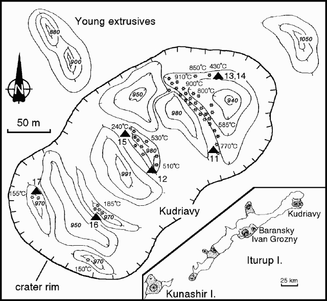 |
Figure 1. Sketch map of the summit area of the Kudriavy cone at Medvezhia, showing fumarole temperatures and elevations of some thermal features, August-October 1992. Contour interval is 10 m. Triangles mark collection sites for gas samples. The inset map shows Iturup Island, with locations of Kudriavy, Baransky, and Ivan Grozny volcanoes, plus the NE corner of neighboring Kunashir Island. Courtesy of G. Steinberg. |
Table 1. Fumarole temperatures, mole percent H2O, and volume percent of dry gas species from Kudriavy, August 1990. Data does not include N2, O2, or Ar. Sample localities are shown on figure 1. Analyses by U.A. Taran and U.A. Ignatorich. Data courtesy of G. Steinberg.
| Sample | 11 | 12 | 13 | 14 | 15 | 16 | 17 |
| Temp. (°C) | 770 | 511 | 430 | 430 | 240 | 160 | 156 |
| H2O (mole %) | 96.0 | 96.1 | 96.7 | 95.6 | 96.4 | 81.5 | 78.8 |
| CO2 | 63.78 | 78.28 | 40.57 | 41.61 | 82.25 | 83.28 | 83.51 |
| H2S | 6.67 | 11.06 | 27.80 | 28.50 | 5.35 | 8.50 | 10.48 |
| SO2 | 13.44 | 5.06 | 9.77 | 9.50 | 6.38 | 3.19 | 4.02 |
| H2 | 8.98 | 1.56 | 8.53 | 8.33 | 0.08 | 0.23 | 0.15 |
| HCl | 6.52 | 4.00 | 13.11 | 11.30 | 2.52 | 0.06 | 1.17 |
| HF | 0.40 | -- | 0.69 | 0.65 | 0.29 | 0.01 | 0.15 |
| CO | 0.19 | 0.01 | 0.035 | 0.060 | 0 | 0 | 0 |
| CH4 | 0 | 0.007 | 0.14 | 0.04 | 0.18 | 0.014 | 0.013 |
Information Contacts: G. Steinberg, Yuzhno-Sakhalinsk.
Measurements of SO2 in Kudriavy plume
The Kudriavy cone at Medvezhia has been the subject of great interest since Korzhinsky and others (1994) discovered a pure rhenium sulfide mineral in its high-temperature (535°C) fumaroles. Given the concentration of Re found in gas samples (2-10 ppb), the occurrence of ReS2 or Re2S3 (exact form still uncertain) requires enrichment of Re by eight orders of magnitude. During a 21 August-5 September visit, Stan Williams, Tobias Fisher, and Russian colleagues made COSPEC measurements of SO2 flux. Gas samples were also collected from crater fumaroles.
The COSPEC was operated from the base camp (150 m elevation) 2.7 km SE of the elongate ENE-WSW summit (990 m elevation), while the wind velocity was measured at the summit using a hand-held anemometer. The first measurements were made on 28 August in vertically oriented stationary mode with the wind blowing the wide gas plume directly over the camp. Wind velocity was measured at 3 m/s and the plume was estimated to be rising only 50 m above the summit before being blown downwind. The flux was found to be 100 +- 20 metric tons/day (t/d) for the three measurements possible before the wind shifted to the SW, making any measurements essentially oblique to the plume axis, and therefore of great uncertainty. An occasional strong odor of H2S was detected at the camp during measurements.
During a crater visits on 29 and 31 August, and during a helicopter flight downwind in the plume, there was always a strong odor of H2S. Under clear skies on 31 August the wind carried the plume SW, allowing stationary mode vertical and horizontal measurements. One specific goal of the research was to quantify the output of the isolated fumarole fields with different temperatures, which was possible for part of the day. Wind velocity was measured at 3 m/s and the SO2 flux was calculated to be only 30 +- 10 t/d.
Kudriavy has been consistently degassing passively at high temperatures since at least 1961, when it was first visited by Russian scientists; annual fieldwork began in 1989. No change in activity was noted during this visit. At the low levels at which Kudriavy was found to be degassing, a realistic SO2 norm may be 75 +- 50 t/d, with the oscillations potentially reflecting meteoric conditions. These low-pressure fumaroles, some with temperatures up to 950°C, produced hissing to roaring to deafening levels of noise. There was more noise and higher flux than at Momotombo (Nicaragua), where 950°C fumaroles were studied through the early to mid-1980s by U.S. and Russian collaboration.
Reference. Korzhinsky, M.A., Tkachenko, S.I., Shmulovich, K.I., Taran, Y.A., and Steinberg, G.S., 1994, Discovery of a pure rhenium mineral at Kudriavy volcano: Nature, v. 369, p. 51-52.
Information Contacts: Stanley N. Williams and Tobias P. Fischer, Geology Dept., Arizona State University, Tempe AZ 85287, USA; Kirill I. Shmulovich and Mikhail A. Korzhinsky, Inst. of Experimental Mineralogy, Russian Academy of Sciences, 142432 Chernogolovka, Moscow District, Russia; Genrikh S. Steinberg, Inst. of Volcanology & Geodynamic ANSRF, 693008 Yuzhno-Sakhalinsk, Box 18, Russia.
Small phreatic eruption from the Kudriavy summit forms a new crater
Changes in activity at the Kudriavy cone (figure 2) were detected in mid-September 1999, preceding an eruption on 7 October. Since 1989 the temperatures of sediments in the dry lakes within the crater (lakes temporarily exist after snow melting and strong rains) at a depth of 0.75 m have consistently fallen in the range of 48-82°C, with fluctuations of 3-5°C. In contrast, September 1999 measurements at the control points in the Hot Lake area showed increasing temperatures of 60-102°C. [These temperature measurements have been made 1-3 times each year.]
|
Figure 2. Photograph of fumarolic plumes rising from the crater of the Kudriavy cone at Medvezhia, September-October 1999. Courtesy of G.S. Steinberg. |
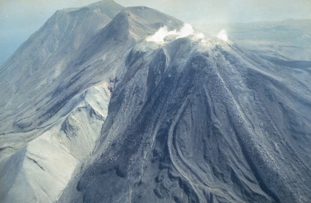
The weather in August, September, and October was unusually dry for the region, with rain only during 24-25 September and 2-3 October. A temperature survey of two lakes was made in September. Usually, lakes exist 1-2 days after rains, but the water in Hot Lake still covered more than half the area on 4 October. Temperatures in the dry part of the lake had increased by 14-22°C. The lake water close to the hot dome was boiling and seething due to gas emissions. [The hot dome is 150-170 m in diameter, rising 60-70 m above the bottom of Hot Lake to the W and 30-40 m above the bottom of the dry lake to the S.] On 5 October the diameter of the lake was 15 m. That day two channels were excavated to allow the water to drain so that sediment temperatures could be measured. The temperature increase in this newly drained area was more than 30°C. Fumarole gas compositions during the second part of September showed increased hydrogen, oxygen, and fluorine. Sulfur ignition was seen in some locations. The number of earthquakes also increased, and although the one-channel seismic station deployed was insufficient to determine any hypocenters, the elevated seismicity was obvious. District and province authorities were warned three days before the start of the 7 October eruption that Kudriavy was unstable and could erupt soon. [On the evening of 4 October the Governor of Sakhalin and the Mayor of Kurilsk were notified that activity at Kudriavy had rapidly increased and that an eruption was expected to begin during the week of 8-15 October, with possible stronger activity later in the month.]
From the base camp, 3.5 km W from the volcano, black and gray clouds of gas and ash were observed rising above the usual fumarolic plumes at 1735 on 7 October and then extending ~10 km NW. Ejections of gas and ash occurred at intervals of 1-2 minutes. Because of the strong winds, maximum altitude of ejections was 1,100 m. The upper camp was at 940 m elevation, 30-40 m from the crater edge and 300 m from Hot Lake (figure 3). Because of strong winds, bad visibility, and the low-intensity start of the eruption, volcanic tremor and gas-and-ash ejections were not noticed in the upper camp until 10 minutes after observers in the base camp saw the plume. Night observations showed that intense ejections stopped at 0200 on 8 October. Observations through the clouds of the N part of the crater revealed "slight reddish lights - reflected light of the hot rocks and blue lights - light of the burning sulfur" that marked the edges of a crater.
|
Figure 3. Aerial photograph of the N part of the Kudriavy crater at Medvezhia showing the locations of the upper camp and the new explosion crater W of the hot lava dome during 7-8 October 1999. North is to the left. Courtesy of G.S. Steinberg. |
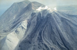
No juvenile ash was identified, so the eruption was determined to be phreatic. This eruption was similar to a geyser eruption: periodic vertical ejection of the gas, ash, and steam. Ejecta didn't fall more than 30-40 m from the new crater. The surface of Hot Lake was covered by rocks with diameters of 20-30 cm, and ashfall deposits were concentrated to the NW. The volume of erupted material was nearly 40,000-45,000 m3. Areas with rhenium mineralization (see BGVN 20:10) located on the dome were not involved in the eruption or covered by eruption products. The first phase of the eruption was over on 13 October.
The eruption created a new crater in the Hot Lake area and removed part of the dome (figure 4). The crater was elliptical with dimensions of 30 x 40 m and a depth 35-40 m from the bottom of the lake and 80-110 m from the flat part of the dome (figure 5). The walls of the crater were vertical. In the lower part of the S crater wall was a 6 x 8 m cave of incandescent rocks. Based on the light intensity, the temperature was estimated to be higher than 1,000-1,100°C. Hot gas rose from this area and condensed 40-60 m above the edge of the crater. Small fiery areas and fragments with burning sulfur were seen on the S, W, and N walls. [Minor explosions continued from the cave until 13 October. Activity then declined, consisting of gas emissions with some small rock fragments that didn't reach the crater rim. No significant changes were noted through 2 November, when observations ended.]
|
Figure 4. Photograph of the hot dome and dry lake area in the N part of the Kudriavy crater at Medvezhia prior to the 7-8 October 1999 eruption. Courtesy of G.S. Steinberg. |
|
Figure 5. Photograph of the 7-8 October 1999 crater adjacent to the hot dome in the N part of the Kudriavy crater at Medvezhia, October 1999. Courtesy of G.S. Steinberg. |
Information Contacts: Genrikh S. Steinberg, Institute of Volcanology and Geodynamics, Russian Academy of Natural Science, Box 18, Yuzhno-Sakhalinsk 693008, Russia.
This compilation of synonyms and subsidiary features may not be comprehensive. Features are organized into four major categories: Cones, Craters, Domes, and Thermal Features. Synonyms of features appear indented below the primary name. In some cases additional feature type, elevation, or location details are provided.
Synonyms |
||||
| Medvezhii | Maioro | ||||
Cones |
||||
| Feature Name | Feature Type | Elevation | Latitude | Longitude |
| Korotyshka | Pyroclastic cone | |||
| Lagerny | Pyroclastic cone | |||
| Medvezhii | Stratovolcano | 1125 m | ||
|
Moyorodake
Io Subai Myoro-dake Moyoro-dake Kudriavy Kudryavyi Maioro Iozan |
Stratovolcano | 991 m | 45° 23' 12" N | 148° 50' 33" E |
| Pereval | Pyroclastic cone | |||
| Sirenevy | Stratovolcano | |||
| Srednii | Stratovolcano | 1113 m | 45° 23' 0" N | 148° 49' 0" E |
|
Tukap
Ainu Tukap |
Stratovolcano | 960 m | ||
| Vostok | Pyroclastic cone | |||
Domes |
||||
| Feature Name | Feature Type | Elevation | Latitude | Longitude |
| Ameba | Dome | |||
| Kulichi | Dome | |||
|
Menshoi Brat
Yaki Aki Menshiy Brat Yakeyama |
Dome | 562 m | 45° 23' 0" N | 148° 46' 0" E |
|
|
||||||||||||||||||||||||
There is data available for 5 confirmed Holocene eruptive periods.
1999 Oct 7 - 1999 Oct 13 Confirmed Eruption Max VEI: 1
| Episode 1 | Eruption Episode | Kudriavy | |||||||||||||||||||||||||||||
|---|---|---|---|---|---|---|---|---|---|---|---|---|---|---|---|---|---|---|---|---|---|---|---|---|---|---|---|---|---|---|
| 1999 Oct 7 - 1999 Oct 13 | Evidence from Observations: Reported | |||||||||||||||||||||||||||||
|
List of 4 Events for Episode 1 at Kudriavy
| ||||||||||||||||||||||||||||||
1958 Jul 2 ± 182 days Confirmed Eruption Max VEI: 1
| Episode 1 | Eruption Episode | Kudriavy | |||||||||||||||||||
|---|---|---|---|---|---|---|---|---|---|---|---|---|---|---|---|---|---|---|---|---|
| 1958 Jul 2 ± 182 days - Unknown | Evidence from Observations: Reported | |||||||||||||||||||
|
List of 2 Events for Episode 1 at Kudriavy
| ||||||||||||||||||||
[ 1946 ] Uncertain Eruption
| Episode 1 | Eruption Episode | Kudriavy | |||||||||||||||||||
|---|---|---|---|---|---|---|---|---|---|---|---|---|---|---|---|---|---|---|---|---|
| 1946 - Unknown | Evidence from Unknown | |||||||||||||||||||
|
List of 2 Events for Episode 1 at Kudriavy
| ||||||||||||||||||||
1883 May - 1883 Jun Confirmed Eruption Max VEI: 2
| Episode 1 | Eruption Episode | Kudriavy | ||||||||||||||||||||||||
|---|---|---|---|---|---|---|---|---|---|---|---|---|---|---|---|---|---|---|---|---|---|---|---|---|---|
| 1883 May - 1883 Jun | Evidence from Observations: Reported | ||||||||||||||||||||||||
|
List of 3 Events for Episode 1 at Kudriavy
| |||||||||||||||||||||||||
1778 Dec 31 ± 365 days Confirmed Eruption Max VEI: 2
| Episode 1 | Eruption Episode | Kudriavy | |||||||||||||||||||
|---|---|---|---|---|---|---|---|---|---|---|---|---|---|---|---|---|---|---|---|---|
| 1778 Dec 31 ± 365 days - Unknown | Evidence from Observations: Reported | |||||||||||||||||||
|
List of 2 Events for Episode 1 at Kudriavy
| ||||||||||||||||||||
0050 BCE (?) Confirmed Eruption
| Episode 1 | Eruption Episode | ||||||||||||||||||||
|---|---|---|---|---|---|---|---|---|---|---|---|---|---|---|---|---|---|---|---|---|
| 0050 BCE (?) - Unknown | Evidence from Correlation: Tephrochronology | |||||||||||||||||||
|
List of 2 Events for Episode 1
| ||||||||||||||||||||
There is no Deformation History data available for Moyorodake [Medvezhia].
There is no Emissions History data available for Moyorodake [Medvezhia].
 Moyorodake is a complex of several cones and lava domes at the NE tip of Iturup Island. The easternmost and highest, Medvezhii (top left) is along the Pacific coast. Srednii (center) is immediately to the west and has produced lava flows that reached the coast. The slightly lower historically active Moyorodake cone (right-center) has also produced lava flows.
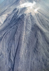 Lava flows, many with prominent marginal levees, descend the W flank of Moyorodake. This is one of four cones constructed along an NE-SW line and it has two shallow craters. The western crater has produced a thick lava flow and numerous other lava flows that form the flanks of the cone and extend 2-3 km. This cone had eruptions in 1778 or 1779, 1883, and 1958.
The maps shown below have been scanned from the GVP map archives and include the volcano on this page. Clicking on the small images will load the full 300 dpi map. Very small-scale maps (such as world maps) are not included. The maps database originated over 30 years ago, but was only recently updated and connected to our main database. We welcome users to tell us if they see incorrect information or other problems with the maps; please use the Contact GVP link at the bottom of the page to send us email.
The following 3 samples associated with this volcano can be found in the Smithsonian's NMNH Department of Mineral Sciences collections, and may be availble for research (contact the Rock and Ore Collections Manager). Catalog number links will open a window with more information.
| Catalog Number | Sample Description | Lava Source | Collection Date |
|---|---|---|---|
| NMNH 116543-16 | Basalt | KUDRIAVY | -- |
| NMNH 116543-17 | Dacite | KUDRIAVY | -- |
| NMNH 116617 | Rhenievite | KUDRIAVY | -- |
| Copernicus Browser | The Copernicus Browser replaced the Sentinel Hub Playground browser in 2023, to provide access to Earth observation archives from the Copernicus Data Space Ecosystem, the main distribution platform for data from the EU Copernicus missions. |
| MIROVA | Middle InfraRed Observation of Volcanic Activity (MIROVA) is a near real time volcanic hot-spot detection system based on the analysis of MODIS (Moderate Resolution Imaging Spectroradiometer) data. In particular, MIROVA uses the Middle InfraRed Radiation (MIR), measured over target volcanoes, in order to detect, locate and measure the heat radiation sourced from volcanic activity. |
| MODVOLC Thermal Alerts | Using infrared satellite Moderate Resolution Imaging Spectroradiometer (MODIS) data, scientists at the Hawai'i Institute of Geophysics and Planetology, University of Hawai'i, developed an automated system called MODVOLC to map thermal hot-spots in near real time. For each MODIS image, the algorithm automatically scans each 1 km pixel within it to check for high-temperature hot-spots. When one is found the date, time, location, and intensity are recorded. MODIS looks at every square km of the Earth every 48 hours, once during the day and once during the night, and the presence of two MODIS sensors in space allows at least four hot-spot observations every two days. Each day updated global maps are compiled to display the locations of all hot spots detected in the previous 24 hours. There is a drop-down list with volcano names which allow users to 'zoom-in' and examine the distribution of hot-spots at a variety of spatial scales. |
|
WOVOdat
Single Volcano View Temporal Evolution of Unrest Side by Side Volcanoes |
WOVOdat is a database of volcanic unrest; instrumentally and visually recorded changes in seismicity, ground deformation, gas emission, and other parameters from their normal baselines. It is sponsored by the World Organization of Volcano Observatories (WOVO) and presently hosted at the Earth Observatory of Singapore.
GVMID Data on Volcano Monitoring Infrastructure The Global Volcano Monitoring Infrastructure Database GVMID, is aimed at documenting and improving capabilities of volcano monitoring from the ground and space. GVMID should provide a snapshot and baseline view of the techniques and instrumentation that are in place at various volcanoes, which can be use by volcano observatories as reference to setup new monitoring system or improving networks at a specific volcano. These data will allow identification of what monitoring gaps exist, which can be then targeted by remote sensing infrastructure and future instrument deployments. |
| Volcanic Hazard Maps | The IAVCEI Commission on Volcanic Hazards and Risk has a Volcanic Hazard Maps database designed to serve as a resource for hazard mappers (or other interested parties) to explore how common issues in hazard map development have been addressed at different volcanoes, in different countries, for different hazards, and for different intended audiences. In addition to the comprehensive, searchable Volcanic Hazard Maps Database, this website contains information about diversity of volcanic hazard maps, illustrated using examples from the database. This site is for educational purposes related to volcanic hazard maps. Hazard maps found on this website should not be used for emergency purposes. For the most recent, official hazard map for a particular volcano, please seek out the proper institutional authorities on the matter. |
| IRIS seismic stations/networks | Incorporated Research Institutions for Seismology (IRIS) Data Services map showing the location of seismic stations from all available networks (permanent or temporary) within a radius of 0.18° (about 20 km at mid-latitudes) from the given location of Moyorodake [Medvezhia]. Users can customize a variety of filters and options in the left panel. Note that if there are no stations are known the map will default to show the entire world with a "No data matched request" error notice. |
| UNAVCO GPS/GNSS stations | Geodetic Data Services map from UNAVCO showing the location of GPS/GNSS stations from all available networks (permanent or temporary) within a radius of 20 km from the given location of Moyorodake [Medvezhia]. Users can customize the data search based on station or network names, location, and time window. Requires Adobe Flash Player. |
| DECADE Data | The DECADE portal, still in the developmental stage, serves as an example of the proposed interoperability between The Smithsonian Institution's Global Volcanism Program, the Mapping Gas Emissions (MaGa) Database, and the EarthChem Geochemical Portal. The Deep Earth Carbon Degassing (DECADE) initiative seeks to use new and established technologies to determine accurate global fluxes of volcanic CO2 to the atmosphere, but installing CO2 monitoring networks on 20 of the world's 150 most actively degassing volcanoes. The group uses related laboratory-based studies (direct gas sampling and analysis, melt inclusions) to provide new data for direct degassing of deep earth carbon to the atmosphere. |
| Large Eruptions of Moyorodake [Medvezhia] | Information about large Quaternary eruptions (VEI >= 4) is cataloged in the Large Magnitude Explosive Volcanic Eruptions (LaMEVE) database of the Volcano Global Risk Identification and Analysis Project (VOGRIPA). |
| EarthChem | EarthChem develops and maintains databases, software, and services that support the preservation, discovery, access and analysis of geochemical data, and facilitate their integration with the broad array of other available earth science parameters. EarthChem is operated by a joint team of disciplinary scientists, data scientists, data managers and information technology developers who are part of the NSF-funded data facility Integrated Earth Data Applications (IEDA). IEDA is a collaborative effort of EarthChem and the Marine Geoscience Data System (MGDS). |

