


On 12 May AVO changed the Aviation Color Code and Volcano Alert Level for Ukinrek-Maars to Green and Normal, respectively, reflecting that communication with seismic stations had been re-established, allowing for the location of earthquakes and detection of unrest.
Source: US Geological Survey Alaska Volcano Observatory (AVO)
Earthquake swarm decreases in rate and intensity
During the last week of May, the anomalous seismic activity under SW Lake Becharof (BGVN 23:04) continued but at a decreased rate and intensity; magnitudes of 12 located earthquakes ranged from M 1.7 to 3.3. During 1-5 June, 20 earthquakes were located ranging from M 1.8 to 4.3. Activity decreased significantly during 6-12 June; only four earthquakes were located, all M > 3.0. Several overflights of the location by AVO scientists revealed no signs of volcanic activity or surface breakage. The area of seismicity was not monitored by real-time seismic instrumentation; however, a portable seismic instrument has recently been installed. AVO is in communication with local citizens and land managers who frequently overfly the area. There was no evidence of imminent hazard at the site.
Information Contacts: Alaska Volcano Observatory (AVO), a cooperative program of a) U.S. Geological Survey, 4200 University Drive, Anchorage, AK 99508-4667, USA (URL: http://www.avo.alaska.edu/), b) Geophysical Institute, University of Alaska, PO Box 757320, Fairbanks, AK 99775-7320, USA, and c) Alaska Division of Geological & Geophysical Surveys, 794 University Ave., Suite 200, Fairbanks, AK 99709, USA.
On 12 May AVO changed the Aviation Color Code and Volcano Alert Level for Ukinrek-Maars to Green and Normal, respectively, reflecting that communication with seismic stations had been re-established, allowing for the location of earthquakes and detection of unrest.
Source: US Geological Survey Alaska Volcano Observatory (AVO)
AVO reported a loss of operation and communication with seismic stations that monitor Ukinrek-Maars, likely caused by snow cover. Both the Aviation Color Code and the Volcano Alert Level were changed to Unassigned on 19 April, reflecting the inability to locate earthquakes to detect unrest. Monitoring will continue with the remaining seismic stations, regional infrasound networks, lightning detection, and satellite images.
Source: US Geological Survey Alaska Volcano Observatory (AVO)
Reports are organized chronologically and indexed below by Month/Year (Publication Volume:Number), and include a one-line summary. Click on the index link or scroll down to read the reports.
Explosions send ash plume above 6 km height
On 30 March, explosions were reported at 1500 and 1720 from a vent 13 km [but see 2:4] NW of Peulik volcano. The latter explosion was viewed from close range from a Wien Air Alaska plane. Its crew reported that the dense, ash-laden eruption cloud rose higher than 6,000 m. Peulik, an 1,844-m stratovolcano with a dacite lava dome, last erupted in 1852. It is surrounded by several small olivine andesite scoria cones.
Information Contacts: T. Miller, USGS, Anchorage.
Two new maars formed NW of Peulik volcano after 30 March
Two new maars formed in tundra terrain, 15 km NW of Peulik volcano, between 30 March and 9 April. Explosions were first observed on 30 March from 70 km SW of the eruption site. Pilots who overflew the eruption at 1725 and 1800 reported a single vent, 20-30 m in diameter, that emitted white steam, then a dark, ash-laden cloud that rose 6,000-7,500 m. Fine ash fell 135 km ESE of the vent, and a sulfurous haze layer lay over Kodiak (250 km E of the vent) all day. More ash clouds were seen on 1 and 2 April.
On 2 April, the original crater had filled with water and become quiescent, and a new 60-m-diameter vent had formed 500 m to the E. By the early afternoon of 3 April, the E crater had grown to about 100 m in diameter and contained a yellowish-orange lava lake. Fragments up to 1 m across were being ejected to 300 m height. Later in the afternoon, 15-20-m lava fountains were observed.
An ash cloud rising more than 4,000 m deposited traces of ash 95 km to the N on 5 April, but by 6 April activity had declined to steam emission and some ash explosions, which sent tephra to more than 1,000 m above the lava lake. Similar activity, including 30-m orange-red lava fountains, was reported on 7 April. No further eruptions were reported until the early morning of 9 April, when violent explosions of incandescent material were seen 30 km away.
A team of volcanologists from the University of Alaska and Dartmouth College visited the eruption site 14-21 April. The W crater was oblong (150 x 65 m) and filled with lukewarm, slightly acidic water. The E crater was about 250 m in diameter and 100 m deep. About 2/3 of its floor was occupied by a lava dome up to 40 m high that was degassing and was coated with sulfur and hematite. Ground water emerged from the crater walls at 50-70 m depth and cascaded onto the dome, where it flashed to steam. Occasional ash puffs were created by the caving of the steep crater walls. Blocks and boulders of highly variable composition and various degrees of rounding, and olivine basalt bombs with lithic cores, decreased in size from 1.5 m in diameter near the crater rims to about 50 cm diameter a few hundred meters away. Fist-sized cinders fell as far as 2 km away. Stripped bark, and mud with imbedded scoria plastered against tree trunks 500 m from the vents, indicate at least minor base surge activity during 1 or more explosions of the E crater.
Two portable short-period seismograph systems, which operated from 15-20 April, recorded a high level of microearthquake activity and three distinct earthquake swarms of several hours duration. More than 1 event per minute was recorded during the swarms. Many of the smaller events were shallow, but some of the larger ones showed S-P times indicating hypocenter depths between a few km and 20 km. Some of the larger events were also recorded by a permanent University of Alaska seismic station 25 km N of the eruption site.
Information Contacts: J. Kienle, Univ. of Alaska.
Periodic earthquake swarms near the new vents
When visited in late May, the E vent was filling with water. A glow could be seen through fractures in the E vent dome, which had ceased growing and was degassing less vigorously than in mid-April. The vents are located on the Bruin Bay Fault. Its projected trend cuts an area of about 12 new hot springs that have formed about 3 km to the N in Becharof Lake. Periodic earthquake swarms continued to occur in the vicinity of the new vents. A third seismograph station was added in late May to the two installed in April.
Further References. Kienle, J., Kyle, P.R., Self, S., Motyka, R.J., and Lorenz, V., 1980, Ukinrek Maars, Alaska, I. April 1977 eruption sequence, petrology and tectonic setting: JVGR, v. 7, p. 11-38.
Kienle, J., and Swanson, S.E., 1983, Volcanism in the eastern Aleutian Arc: late Quaternary and Holocene centers, tectonic setting, and petrology: JVGR, v. 17, p. 393-432. (This reference also contains data on Augustine and Iliamna.)
Self, S., Kienle, J., and Huot, J.P., 1980, Ukinrek Maars, Alaska, II. Deposits and formation of the 1977 craters: JVGR, v. 17, p. 39-66.
Information Contacts: J. Kienle, Univ. of Alaska.
Tectonic earthquake swarm in the Ukinrek Maars area
During 8-9 May, a seismic swarm of tectonic earthquakes shook the middle Alaskan Peninsula region including the towns of King Salmon, Dillingham, Egegik, and Pilot Point. The swarm began with five earthquakes of M 5.2-4.7 occurring between 1630 and 2259. Dozens of earthquakes in the M 2.5-3.5 range were felt locally. The earthquakes continued through 9 May, but the number of earthquakes had decreased notably by the morning of 10 May. Felt earthquakes were still occurring at a rate of 1-2/day as of the afternoon of 12 May.
The earthquakes were clustered on the SW shore of Lake Becharof, approximately 10-20 km NW of the 1977 Ukinrek Maars volcanoes and near the S end of the Bruin Bay fault. The earthquakes were all very shallow (<7 km in depth). In the past, the few local seismic stations have been able to accurately locate earthquakes only of magnitudes greater than M 4. The recent expansion of Alaska Volcano Observatory (AVO) volcano seismic monitoring to include volcanoes in Katmai National Park, NE of Lake Becharof, and Aniakchak Volcano, to the SW, has allowed better detection and location of Becharof earthquakes.
AVO scientists traveled to King Salmon on 9 May for an overflight of the swarm location and vicinity. Their U.S. Fish and Wildlife Service (FWS) pilot had overflown the area the evening of 8 May after the first earthquakes. Nothing indicating any volcanic activity or surface breakage was seen on either flight. Some small slumping was noticed along the SW shoreline of Lake Becharof and some local discoloration by sediments was seen both likely resulting from ground shaking. Similarly, a slight change in the green coloration of the crater lake in the large maar at Ukinrek Maars was likely due to disturbed sediments. No evidence of any disturbance or unusual activity was seen at Peulik volcano. Peulik is heavily snow-covered and showed no sign of discoloration, deformation, or slumping. The area of seismicity is not monitored by real-time seismic instrumentation; scientists scouted for possible locations to establish a temporary seismic net. The net will allow scientists to determine if there is a volcanic component to the earthquake swarm and any potential volcanic hazard. AVO is also in communication with citizens of King Salmon, Egegik, Meshik, and Pilot Point, as well as the National Park Service and FWS pilots who frequently overfly the area.
The preliminary interpretation is that the swarm was of tectonic origin, although the occurrence of five M 4.7-5.2 earthquakes in such a short time with no clear mainshock may suggest a volcanic component. Considering the nature of the formation of Ukinrek Maars in 1977, where no volcano existed previously, intrusion of magma associated with tectonic movement is possible. There is no evidence of imminent volcanic hazard from this seismic swarm.
Background. The May 1998 swarm was the most energetic to date. There were no major seismic events detected in association with the 1977 Ukinrek Maars eruptions, except for a number of small events detected by a portable seismic net which was deployed by the University of Alaska at Fairbanks (UAF) and the U.S. Geological Survey (USGS) for several months following the 1977 eruptions. Ukinrek Maars formed 30 March-10 April, 1977 as a result of magmatic intrusion into water-saturated glacial till 2 km S of Gas Rocks on the S shore of Lake Becharof. During a 10-day period, violent explosions produced steam and ash plumes as high as 6.5 km and light ash fall as far as 160 km to the N. Since the Ukinrek Maars formed, CO2 gas has been continuously emitted from the vicinity of the maars, the Gas Rocks, and from beneath Lake Becharof.
Information Contacts: Alaska Volcano Observatory (AVO), a cooperative program of a) U.S. Geological Survey, 4200 University Drive, Anchorage, AK 99508-4667, USA (URL: http://www.avo.alaska.edu/), b) Geophysical Institute, University of Alaska, PO Box 757320, Fairbanks, AK 99775-7320, USA, and c) Alaska Division of Geological & Geophysical Surveys, 794 University Ave., Suite 200, Fairbanks, AK 99709, USA; Roger Hansen, Geophysical Institute, University of Alaska, PO Box 757320, Fairbanks, AK 99775 USA.
Earthquake swarm decreases in rate and intensity
During the last week of May, the anomalous seismic activity under SW Lake Becharof (BGVN 23:04) continued but at a decreased rate and intensity; magnitudes of 12 located earthquakes ranged from M 1.7 to 3.3. During 1-5 June, 20 earthquakes were located ranging from M 1.8 to 4.3. Activity decreased significantly during 6-12 June; only four earthquakes were located, all M > 3.0. Several overflights of the location by AVO scientists revealed no signs of volcanic activity or surface breakage. The area of seismicity was not monitored by real-time seismic instrumentation; however, a portable seismic instrument has recently been installed. AVO is in communication with local citizens and land managers who frequently overfly the area. There was no evidence of imminent hazard at the site.
Information Contacts: Alaska Volcano Observatory (AVO), a cooperative program of a) U.S. Geological Survey, 4200 University Drive, Anchorage, AK 99508-4667, USA (URL: http://www.avo.alaska.edu/), b) Geophysical Institute, University of Alaska, PO Box 757320, Fairbanks, AK 99775-7320, USA, and c) Alaska Division of Geological & Geophysical Surveys, 794 University Ave., Suite 200, Fairbanks, AK 99709, USA.
|
|
||||||||||||||||||||||||||
There is data available for 2 confirmed eruptive periods.
1977 Mar 30 - 1977 Apr 9 Confirmed Eruption (Explosive / Effusive) VEI: 3
| Episode 1 | Eruption (Explosive / Effusive) | West and East Ukinrek Maars | |||||||||||||||||||||||||||||||||||||||||||||||||||||||||||||||
|---|---|---|---|---|---|---|---|---|---|---|---|---|---|---|---|---|---|---|---|---|---|---|---|---|---|---|---|---|---|---|---|---|---|---|---|---|---|---|---|---|---|---|---|---|---|---|---|---|---|---|---|---|---|---|---|---|---|---|---|---|---|---|---|---|
| 1977 Mar 30 - 1977 Apr 9 | Evidence from Observations: Reported | |||||||||||||||||||||||||||||||||||||||||||||||||||||||||||||||
|
List of 11 Events for Episode 1 at West and East Ukinrek Maars
|
||||||||||||||||||||||||||||||||||||||||||||||||||||||||||||||||
0350 BCE (?) Confirmed Eruption (Explosive / Effusive)
| Episode 1 | Eruption (Explosive / Effusive) | Gas Rocks | ||||||||||||||||||
|---|---|---|---|---|---|---|---|---|---|---|---|---|---|---|---|---|---|---|---|
| 0350 BCE (?) - Unknown | Evidence from Isotopic: 14C (uncalibrated) | ||||||||||||||||||
|
List of 2 Events for Episode 1 at Gas Rocks
|
|||||||||||||||||||
This compilation of synonyms and subsidiary features may not be comprehensive. Features are organized into four major categories: Cones, Craters, Domes, and Thermal Features. Synonyms of features appear indented below the primary name. In some cases additional feature type, elevation, or location details are provided.
Craters |
||||
| Feature Name | Feature Type | Elevation | Latitude | Longitude |
| East Maar | Maar | |||
| West Maar | Maar | |||
Domes |
||||
| Feature Name | Feature Type | Elevation | Latitude | Longitude |
| Gas Rocks, The | Dome | |||
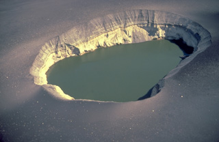 The 300-m-wide East Maar is one of the two Ukinrek Maars, which were formed during an eruption in 1977 through glacial deposits on the Alaska Peninsula. This fresh maar, in contrast to older ones whose rims have been modified by slumping and erosion, has steep-sided walls. The explosions blasted through the pre-existing, light-colored glacial till forming the bottom half of the distant crater wall and then deposited the dark, bedded layers in the upper half of the crater wall as well as the dark blanket of blocks and ash surrounding the maar.
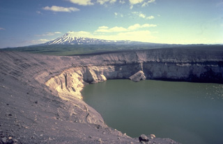 The Ukinrek Maars were formed during an eruption in 1977 at a Bering Sea lowland area without previous volcanic activity. Powerful phreatomagmatic explosions formed the 170-m-wide West Maar and 300-m-wide East Maar. The maars were named from the Yupik Eskimo words for "two holes in the ground." Late in the 10-day-long eruption a lava dome formed in East Maar, seen here from the NW rim with Peulik volcano in the background. The dome is now submerged beneath a 60-m-deep lake.
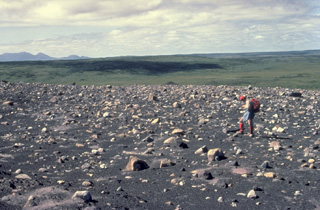 French volcanologist Katia Krafft observes blocky ejecta from the 1977 eruptions that formed Ukinrek Maars. The 10-day-long eruption produced two new maars, 170-m-wide West Maar and 300-m-wide East Maar. Phreatomagmatic explosions formed an ejecta blanket of ash and blocks that surrounded the new vents.
 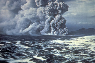 Phreatomagmatic eruptions produced when magma came in contact with groundwater eject an ash plume at the Ukinrek Maars on the Alaska Peninsula. This photo from the south on 5 April 1977 shows explosive eruptions from East Maar, one of two new craters that formed in glacial sediments, in an area without previous volcanic activity. The hummocky, snow-covered surface in the foreground is a debris avalanche deposit from Peulik.
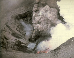 An aerial view into East Maar on 3 April 1977 shows incandescent lava on the floor of the crater and a small vent above it that is producing an ash plume. The 1977 eruptions of Ukinrek Maars began on 30 March at West Maar, which formed during the first three days of the eruption. East Maar formed during the next seven days at a location 600 m E. A lava dome, now covered by a crater lake, formed on the floor of East Maar.
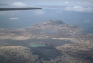 Ukinrek Maars are two phreatomagmatic explosion craters that were created in an area without previous volcanic activity during a 10-day-long eruption that began on 30 March 1977. A greenish lake fills East Maar, the largest of the two in this 1994 view from the south. The smaller West Maar is surrounded by dark tephra near the left margin. Gas Rocks, an older volcanic center, forms the peninsula extending into Becharof Lake in the background.
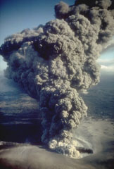 An ash plume erupts from eastern crater of the newly formed Ukinrek Maars on 6 April 1977. West Maar formed during the initial days of the eruption that began on 30 March. Three days later explosions began at East Maar, 600 m away. At the peak of the eruption ash plumes reached up to 6 km above the vent. On the 4th day of the eruption a lava dome appeared within East Maar.
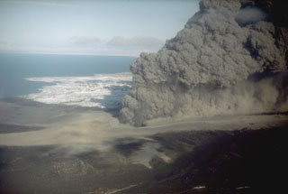 The interaction of magma with groundwater produced this dark, ash-rich eruption column in 1977 from the Ukinrek Maars on the Alaska Peninsula. The eruption occurred in an area without previous volcanic activity, through surficial glacial deposits. The phreatomagmatic explosions created two new craters, which were named after the Yupik words for "two holes in the ground." This photo was taken from the WSW on 6 April 1977.
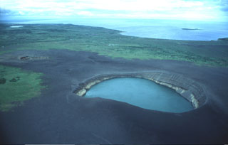 This lake-filled maar and another small crater (left) are the Ukinrek Maars, which formed during an eruption in 1977 in a lowland area of the Alaska Peninsula west of the main volcanic chain. The contact between lighter and darker material in the walls of the lake-filled eastern maar marks the original pre-eruption surface, which is now buried by a dark apron of ejecta produced during the eruption.
There are no samples for Ukinrek Maars in the Smithsonian's NMNH Department of Mineral Sciences Rock and Ore collection.
| Alaska Volcano Observatory (Link to Ukinrek Maars) | The Alaska Volcano Observatory (AVO) is a joint program of the U.S. Geological Survey (USGS), the Geophysical Institute of the University of Alaska Fairbanks (UAFGI), and the State of Alaska Division of Geological and Geophysical Surveys (ADGGS). AVO was formed in 1988, and uses federal, state, and university resources to monitor and study Alaska's hazardous volcanoes, to predict and record eruptive activity, and to mitigate volcanic hazards to life and property. |
| Copernicus Browser | The Copernicus Browser replaced the Sentinel Hub Playground browser in 2023, to provide access to Earth observation archives from the Copernicus Data Space Ecosystem, the main distribution platform for data from the EU Copernicus missions. |
| MIROVA | Middle InfraRed Observation of Volcanic Activity (MIROVA) is a near real time volcanic hot-spot detection system based on the analysis of MODIS (Moderate Resolution Imaging Spectroradiometer) data. In particular, MIROVA uses the Middle InfraRed Radiation (MIR), measured over target volcanoes, in order to detect, locate and measure the heat radiation sourced from volcanic activity. |
| MODVOLC Thermal Alerts | Using infrared satellite Moderate Resolution Imaging Spectroradiometer (MODIS) data, scientists at the Hawai'i Institute of Geophysics and Planetology, University of Hawai'i, developed an automated system called MODVOLC to map thermal hot-spots in near real time. For each MODIS image, the algorithm automatically scans each 1 km pixel within it to check for high-temperature hot-spots. When one is found the date, time, location, and intensity are recorded. MODIS looks at every square km of the Earth every 48 hours, once during the day and once during the night, and the presence of two MODIS sensors in space allows at least four hot-spot observations every two days. Each day updated global maps are compiled to display the locations of all hot spots detected in the previous 24 hours. There is a drop-down list with volcano names which allow users to 'zoom-in' and examine the distribution of hot-spots at a variety of spatial scales. |
|
WOVOdat
Single Volcano View Temporal Evolution of Unrest Side by Side Volcanoes |
WOVOdat is a database of volcanic unrest; instrumentally and visually recorded changes in seismicity, ground deformation, gas emission, and other parameters from their normal baselines. It is sponsored by the World Organization of Volcano Observatories (WOVO) and presently hosted at the Earth Observatory of Singapore.
GVMID Data on Volcano Monitoring Infrastructure The Global Volcano Monitoring Infrastructure Database GVMID, is aimed at documenting and improving capabilities of volcano monitoring from the ground and space. GVMID should provide a snapshot and baseline view of the techniques and instrumentation that are in place at various volcanoes, which can be use by volcano observatories as reference to setup new monitoring system or improving networks at a specific volcano. These data will allow identification of what monitoring gaps exist, which can be then targeted by remote sensing infrastructure and future instrument deployments. |
| Volcanic Hazard Maps | The IAVCEI Commission on Volcanic Hazards and Risk has a Volcanic Hazard Maps database designed to serve as a resource for hazard mappers (or other interested parties) to explore how common issues in hazard map development have been addressed at different volcanoes, in different countries, for different hazards, and for different intended audiences. In addition to the comprehensive, searchable Volcanic Hazard Maps Database, this website contains information about diversity of volcanic hazard maps, illustrated using examples from the database. This site is for educational purposes related to volcanic hazard maps. Hazard maps found on this website should not be used for emergency purposes. For the most recent, official hazard map for a particular volcano, please seek out the proper institutional authorities on the matter. |
| IRIS seismic stations/networks | Incorporated Research Institutions for Seismology (IRIS) Data Services map showing the location of seismic stations from all available networks (permanent or temporary) within a radius of 0.18° (about 20 km at mid-latitudes) from the given location of Ukinrek Maars. Users can customize a variety of filters and options in the left panel. Note that if there are no stations are known the map will default to show the entire world with a "No data matched request" error notice. |
| UNAVCO GPS/GNSS stations | Geodetic Data Services map from UNAVCO showing the location of GPS/GNSS stations from all available networks (permanent or temporary) within a radius of 20 km from the given location of Ukinrek Maars. Users can customize the data search based on station or network names, location, and time window. Requires Adobe Flash Player. |
| DECADE Data | The DECADE portal, still in the developmental stage, serves as an example of the proposed interoperability between The Smithsonian Institution's Global Volcanism Program, the Mapping Gas Emissions (MaGa) Database, and the EarthChem Geochemical Portal. The Deep Earth Carbon Degassing (DECADE) initiative seeks to use new and established technologies to determine accurate global fluxes of volcanic CO2 to the atmosphere, but installing CO2 monitoring networks on 20 of the world's 150 most actively degassing volcanoes. The group uses related laboratory-based studies (direct gas sampling and analysis, melt inclusions) to provide new data for direct degassing of deep earth carbon to the atmosphere. |
| Large Eruptions of Ukinrek Maars | Information about large Quaternary eruptions (VEI >= 4) is cataloged in the Large Magnitude Explosive Volcanic Eruptions (LaMEVE) database of the Volcano Global Risk Identification and Analysis Project (VOGRIPA). |
| EarthChem | EarthChem develops and maintains databases, software, and services that support the preservation, discovery, access and analysis of geochemical data, and facilitate their integration with the broad array of other available earth science parameters. EarthChem is operated by a joint team of disciplinary scientists, data scientists, data managers and information technology developers who are part of the NSF-funded data facility Integrated Earth Data Applications (IEDA). IEDA is a collaborative effort of EarthChem and the Marine Geoscience Data System (MGDS). |