

AVO reported that during 3-4 and 9 October strong winds in the vicinity of Katmai and the Valley of Ten Thousand Smokes dispersed unconsolidated ash up to 1.5 km (5,000 ft) a.s.l. to the W and SE. The ash was originally deposited during the Novarupta-Katmai eruption in 1912. The Volcano Alert Level remained at Normal (the lowest level on a four-level scale) and the Aviation Color Code remained at Green (the lowest level on a four-color scale).
Source: US Geological Survey Alaska Volcano Observatory (AVO)
2023: April
| August
| October
2022: April
| May
| June
| October
2021: August
| September
| November
2020: October
AVO reported that during 3-4 and 9 October strong winds in the vicinity of Katmai and the Valley of Ten Thousand Smokes dispersed unconsolidated ash up to 1.5 km (5,000 ft) a.s.l. to the W and SE. The ash was originally deposited during the Novarupta-Katmai eruption in 1912. The Volcano Alert Level remained at Normal (the lowest level on a four-level scale) and the Aviation Color Code remained at Green (the lowest level on a four-color scale).
Source: US Geological Survey Alaska Volcano Observatory (AVO)
AVO reported that beginning at about 1430 on 4 August, strong SE winds in the vicinity of Katmai and the Valley of Ten Thousand Smokes dispersed unconsolidated ash up to 1.8 km (6,000 ft) a.s.l. to the NW. The ash was originally deposited during the Novarupta-Katmai eruption in 1912. The Volcano Alert Level remained at Normal (the lowest level on a four-level scale) and the Aviation Color Code remained at Green (the lowest level on a four-color scale).
Source: US Geological Survey Alaska Volcano Observatory (AVO)
AVO reported that during the morning of 23 April, strong NW winds in the vicinity of Katmai and the Valley of Ten Thousand Smokes dispersed unconsolidated ash up to 1.8 km (6,000 ft) a.s.l. to the SE across Shelikof Strait to Kodiak Island. The ash was originally deposited during the Novarupta-Katmai eruption in 1912. The Volcano Alert Level remained at Normal (the lowest level on a four-level scale) and the Aviation Color Code remained at Green (the lowest level on a four-color scale).
Source: US Geological Survey Alaska Volcano Observatory (AVO)
AVO reported that on 8 April strong winds in the vicinity of Katmai and the Valley of Ten Thousand Smokes blew unconsolidated ash SE across Shelikof Strait to Kodiak Island at an altitude up to 2.4 km 8,000 ft) a.s.l. The ash was originally deposited during the Novarupta eruption in 1912. The Volcano Alert Level remained at Normal (the lowest level on a four-level scale) and the Aviation Color Code remained at Green (the lowest level on a four-color scale).
Source: US Geological Survey Alaska Volcano Observatory (AVO)
AVO reported that on 9 October strong winds in the vicinity of Katmai and the Valley of Ten Thousand Smokes blew unconsolidated ash SE across Shelikof Strait to Kodiak Island at an altitude up to 1.5 km (5,000 ft) a.s.l. The ash was originally deposited during the Novarupta eruption in 1912. The Volcano Alert Level remained at Normal (the lowest level on a four-level scale) and the Aviation Color Code remained at Green (the lowest level on a four-color scale).
Source: US Geological Survey Alaska Volcano Observatory (AVO)
AVO reported that on 30 June strong winds in the vicinity of Katmai and the Valley of Ten Thousand Smokes blew unconsolidated ash NW at an altitude up to 1.8 km (6,000 ft) a.s.l. The ash was originally deposited during the Novarupta eruption in 1912. The Volcano Alert Level remained at Normal and the Aviation Color Code remained at Green.
Source: US Geological Survey Alaska Volcano Observatory (AVO)
AVO reported that on 20 May strong winds in the vicinity of Katmai and the Valley of Ten Thousand Smokes blew unconsolidated ash WNW at an altitude up to 1.8 km (6,000 ft) a.s.l. The ash was originally deposited during the Novarupta eruption in 1912. The Volcano Alert Level remained at Normal and the Aviation Color Code remained at Green.
Source: US Geological Survey Alaska Volcano Observatory (AVO)
AVO reported that on 13 May strong winds in the vicinity of Katmai and the Valley of Ten Thousand Smokes blew unconsolidated ash SE towards Kodiak Island at an altitude up to 1.8 km (6,000 ft) a.s.l. The ash was originally deposited during the Novarupta eruption in 1912. The Volcano Alert Level remained at Normal and the Aviation Color Code remained at Green.
Source: US Geological Survey Alaska Volcano Observatory (AVO)
AVO reported that on 8 April strong winds in the vicinity of Katmai and the Valley of Ten Thousand Smokes blew unconsolidated ash SE towards Kodiak Island at an altitude up to 2.4 km (8,000 ft) a.s.l. The ash was originally deposited during the Novarupta eruption in 1912. The Volcano Alert Level remained at Normal and the Aviation Color Code remained at Green.
Source: US Geological Survey Alaska Volcano Observatory (AVO)
AVO reported that on 25 November strong winds in the vicinity of Katmai and the Valley of Ten Thousand Smokes blew unconsolidated ash SE over Shelikof Strait and Kodiak Island at an altitude up to 1.5 km (5,000 ft) a.s.l. The ash was originally deposited during the Novarupta eruption in 1912. The Volcano Alert Level remained at Normal and the Aviation Color Code remained at Green.
Source: US Geological Survey Alaska Volcano Observatory (AVO)
AVO reported that during 17-18 November strong winds in the vicinity of Katmai and the Valley of Ten Thousand Smokes blew unconsolidated ash SE over Shelikof Strait and Kodiak Island at an altitude up to 2.1 km (7,000 ft) a.s.l. The ash was originally deposited during the Novarupta eruption in 1912. The Volcano Alert Level remained at Normal and the Aviation Color Code remained at Green.
Source: US Geological Survey Alaska Volcano Observatory (AVO)
AVO reported that beginning at 0400 on 2 October strong winds in the vicinity of Katmai and the Valley of Ten Thousand Smokes blew unconsolidated ash SE towards Kodiak Island at an altitude up to 1.8 km (6,000 ft) a.s.l. The ash was originally deposited during the Novarupta eruption in 1912. The Volcano Alert Level remained at Normal and the Aviation Color Code remained at Green.
Source: US Geological Survey Alaska Volcano Observatory (AVO)
AVO reported that beginning at 1730 on 23 September strong winds in the vicinity of Katmai and the Valley of Ten Thousand Smokes blew unconsolidated ash SE towards Kodiak Island at an altitude up to 1.5 km (5,000 ft) a.s.l. The ash was originally deposited during the Novarupta eruption in 1912. The Volcano Alert Level remained at Normal and the Aviation Color Code remained at Green.
Source: US Geological Survey Alaska Volcano Observatory (AVO)
AVO reported that on 21 September strong winds in the vicinity of Katmai and the Valley of Ten Thousand Smokes blew unconsolidated ash SE towards Kodiak Island at an altitude up to 2.4 km (8,000 ft) a.s.l. The ash was originally deposited during the Novarupta eruption in 1912. The Volcano Alert Level remained at Normal and the Aviation Color Code remained at Green.
Source: US Geological Survey Alaska Volcano Observatory (AVO)
AVO reported that on 28 August strong winds in the vicinity of Katmai and the Valley of Ten Thousand Smokes picked up unconsolidated ash and drifted SE towards Kodiak Island at an altitude up to 1.8 km (6,000 ft) a.s.l. The ash was originally deposited during the Novarupta eruption in 1912. The Volcano Alert Level remained at Normal and the Aviation Color Code remained at Green.
Source: US Geological Survey Alaska Volcano Observatory (AVO)
On 31 October AVO reported that an ash cloud, resuspended by strong winds in the vicinity of Katmai and the Valley of Ten Thousand Smokes, drifted SE over the S part of Kodiak Island at an altitude up to 1.5 km (5,000 ft) a.s.l. The ash was originally deposited during the Novarupta eruption in 1912. The Volcano Alert Level remained at Normal and the Aviation Color Code remained at Green.
Source: US Geological Survey Alaska Volcano Observatory (AVO)
The Global Volcanism Program has no Bulletin Reports available for Katmai.
This compilation of synonyms and subsidiary features may not be comprehensive. Features are organized into four major categories: Cones, Craters, Domes, and Thermal Features. Synonyms of features appear indented below the primary name. In some cases additional feature type, elevation, or location details are provided.
Domes |
||||
| Feature Name | Feature Type | Elevation | Latitude | Longitude |
| Horseshoe Island | Dome | |||
|
|
||||||||||||||||||||||||||
There is data available for 1 confirmed Holocene eruptive periods.
[ 1931 May 8 - 1931 Jul ] Discredited Eruption
Reports of "smoke" may be vapor condensation clouds (Coats, 1950). No credible reports of post-1912 eruptions are noted by Hildreth (1983), and Kienle and Swanson (1983) also list no post-1912 eruptions.
[ 1929 Dec ] Discredited Eruption
Coats (1950) reported unspecified activity in December 1929. However, no credible reports of post-1912 eruptions are noted by Hildreth (1983), and Kienle and Swanson (1983) also list no post-1912 eruptions.
[ 1921 Nov 27 ] Discredited Eruption
Minor eruptions were attributed to Katmai (Ward and Matumoto, 1967). However, no credible reports of post-1912 eruptions are noted by Hildreth (1983), and Kienle and Swanson (1983) also list no post-1912 eruptions.
[ 1920 Mar 9 ] Discredited Eruption
Minor eruptions were attributed to Katmai (Ward and Matumoto, 1967). However, no credible reports of post-1912 eruptions are noted by Hildreth (1983), and Kienle and Swanson (1983) also list no post-1912 eruptions.
[ 1914 Jul ] Discredited Eruption
Coats (1950) reported unspecified activity in 1914. However, no credible reports of post-1912 eruptions are noted by Hildreth (1983), and Kienle and Swanson (1983) also list no post-1912 eruptions.
1912 Jun 6 - 1912 Jul 21 (in or after) Confirmed Eruption Max VEI: 3
| Episode 1 | Eruption Episode | |||||||||||||||||||||||||||||||||||||||||||||
|---|---|---|---|---|---|---|---|---|---|---|---|---|---|---|---|---|---|---|---|---|---|---|---|---|---|---|---|---|---|---|---|---|---|---|---|---|---|---|---|---|---|---|---|---|---|
| 1912 Jun 6 - 1912 Jul 21 (in or after) | Evidence from Observations: Reported | ||||||||||||||||||||||||||||||||||||||||||||
|
List of 7 Events for Episode 1
| |||||||||||||||||||||||||||||||||||||||||||||
There is no Deformation History data available for Katmai.
There is no Emissions History data available for Katmai.
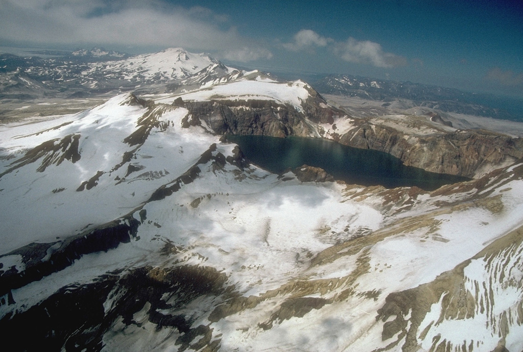
 Alaska's lake-filled Katmai caldera, seen here from the SE, collapsed during a catastrophic eruption in 1912 of Novarupta volcano, hidden behind the far caldera wall 10 km to the west. Little tephra was erupted from Katmai itself, but Novarupta produced the Valley of Ten Thousand Smokes ash flow, whose deposits form the broad flat valley in the right distance. Prior to 1912, Mount Katmai was a 2290-m-high complex of 4 small stratovolcanoes, similar to Trident volcano to the SW.
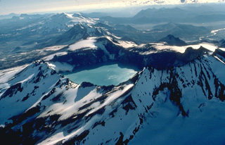 This 1978 aerial view from the NE looks down the SW-trending chain of closely spaced volcanoes in Katmai National Park. Katmai volcano, in the foreground, is truncated by a 4.5-km-wide caldera created by collapse of the volcano in 1912 at the time of the major eruption at Novarupta volcano, 10 km to the west and below the far rim of Katmai caldera. Beyond Katmai, in line with the 250-m-deep caldera lake, are the dark-colored peaks of the Trident complex and the broad, glacier-covered slopes of Mageik volcano.
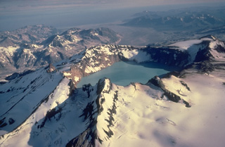
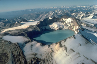 Mount Katmai, seen here from the south, is truncated by a caldera that formed in 1912 during a catastrophic eruption at Novarupta volcano, 10 km to the west. Little eruptive activity occurred at Katmai itself during the collapse. Prior to 1912, Mount Katmai was a 2290-m-high complex of 4 small overlapping stratovolcanoes. The 3 x 4.5 km wide caldera is filled by a lake that was 250-m deep by 1976 and is still rising. The small glaciers on the bench on the north caldera wall began forming shortly after the 1912 eruption.
  Katmai caldera, formed during the catastrophic eruption of the nearby Novarupta vent in June 1912, is seen here in an aerial view from the NE. The steep-walled, 1.5-km-wide caldera formed on a cluster of overlapping cones and is partially filled by a lake. Beyond the caldera are the multiple peaks of Trident volcano; Mageik volcano is the snow-and-ice-covered cone in the background.
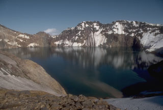 The 3 x 4.5 km Katmai caldera, seen here from its western rim, formed in 1912 by the hydraulic draining of magma away from Katmai to Novarupta 10 km W. Little if any eruptive activity took place at Katmai itself, which prior to collapse was a complex of four small overlapping stratovolcanoes. The 250-m-deep caldera lake covers a small lava dome and tuff ring that erupted on the caldera floor.
The maps shown below have been scanned from the GVP map archives and include the volcano on this page. Clicking on the small images will load the full 300 dpi map. Very small-scale maps (such as world maps) are not included. The maps database originated over 30 years ago, but was only recently updated and connected to our main database. We welcome users to tell us if they see incorrect information or other problems with the maps; please use the Contact GVP link at the bottom of the page to send us email.
The following 76 samples associated with this volcano can be found in the Smithsonian's NMNH Department of Mineral Sciences collections, and may be availble for research (contact the Rock and Ore Collections Manager). Catalog number links will open a window with more information.
| Catalog Number | Sample Description | Lava Source | Collection Date |
|---|---|---|---|
| NMNH 116509-1 | Glass | -- | 18 Aug 1923 |
| NMNH 116509-10 | Andesite | -- | 3 Sep 1923 |
| NMNH 116509-11 | Glass | -- | 10 Oct 1923 |
| NMNH 116509-12 | Basalt | -- | -- |
| NMNH 116509-13 | Glass | -- | 1 Jul 1923 |
| NMNH 116509-14 | Basalt | -- | 27 Jul 1923 |
| NMNH 116509-15 | Dike Rock | -- | 8 Jun 1923 |
| NMNH 116509-16 | Obsidian | -- | 10 Jul 1923 |
| NMNH 116509-17 | Rhyolite | -- | 5 Jul 1923 |
| NMNH 116509-18 | Tuff | -- | -- |
| NMNH 116509-19 | Basalt | -- | 10 Oct 1923 |
| NMNH 116509-2 | Syenite | -- | 6 Jul 1923 |
| NMNH 116509-20 | Obsidian | -- | 10 Jul 1923 |
| NMNH 116509-21 | Granite | -- | 6 Sep 1923 |
| NMNH 116509-22 | Lava | -- | 14 Jul 1923 |
| NMNH 116509-23 | Quartz Porphyry | -- | 4 Aug 1923 |
| NMNH 116509-24 | Glass | -- | 2 Aug 1923 |
| NMNH 116509-25 | Dacite | -- | 10 Oct 1923 |
| NMNH 116509-26 | Rhyolite | -- | 1 Jul 1923 |
| NMNH 116509-3 | Pumice | -- | 19 Jul 1923 |
| NMNH 116509-4 | Glass | -- | 11 Jul 1923 |
| NMNH 116509-5 | Quartz Porphyry | -- | 20 Aug 1923 |
| NMNH 116509-6 | Andesite | -- | 10 Aug 1923 |
| NMNH 116509-7 | Trachyte | -- | 26 Jul 1923 |
| NMNH 116509-8 | Tuff | -- | 2 Aug 1923 |
| NMNH 116509-9 | Pumice | -- | 13 Aug 1923 |
| NMNH 116550-1 | Pumice | -- | 25 Aug 1923 |
| NMNH 116550-10 | Granite | -- | -- |
| NMNH 116550-2 | Pumice | -- | 25 Aug 1923 |
| NMNH 116550-3 | Pumice | -- | 25 Aug 1923 |
| NMNH 116550-4 | Tuffaceous Sand | -- | 8 Jul 1923 |
| NMNH 116550-5 | Tuffaceous Sand | -- | 30 Apr 1935 |
| NMNH 116550-6 | Pumice | -- | -- |
| NMNH 116550-7 | Pumice | -- | -- |
| NMNH 116550-8 | Pumice | -- | -- |
| NMNH 116550-9 | Pumice | -- | -- |
| NMNH 116660-4 | Dacitic Pumice | -- | -- |
| NMNH 117259-1 | Fumarole Deposit | -- | 30 Jun 1919 |
| NMNH 117259-10 | Fumarole Deposit | -- | 4 Jul 1919 |
| NMNH 117259-11 | Fumarole Deposit | -- | 4 Jul 1919 |
| NMNH 117259-12 | Fumarole Deposit | -- | 6 Jul 1919 |
| NMNH 117259-13 | Fumarole Deposit | -- | 4 Jul 1919 |
| NMNH 117259-14 | Fumarole Deposit | -- | 5 Jul 1919 |
| NMNH 117259-15 | Fumarole Deposit | -- | 5 Jul 1919 |
| NMNH 117259-16 | Fumarole Deposit | -- | -- |
| NMNH 117259-17 | Fumarole Deposit | -- | 14 Aug 1919 |
| NMNH 117259-18 | Fumarole Deposit | -- | 14 Aug 1919 |
| NMNH 117259-19 | Fumarole Deposit | -- | 11 Aug 1919 |
| NMNH 117259-2 | Fumarole Deposit | -- | 15 Aug 1919 |
| NMNH 117259-25 | Fumarole Deposit | -- | -- |
| NMNH 117259-26 | Fumarole Deposit | -- | 9 Aug 1919 |
| NMNH 117259-27 | Fumarole Deposit | -- | 9 Aug 1919 |
| NMNH 117259-28 | Fumarole Deposit | -- | 9 Aug 1919 |
| NMNH 117259-29 | Fumarole Deposit | -- | 9 Aug 1919 |
| NMNH 117259-3 | Fumarole Deposit | -- | 12 Aug 1919 |
| NMNH 117259-30 | Fumarole Deposit | -- | 10 Aug 1919 |
| NMNH 117259-31 | Fumarole Deposit | -- | 8 Aug 1919 |
| NMNH 117259-32 | Fumarole Deposit | -- | 11 Aug 1919 |
| NMNH 117259-33 | Fumarole Deposit | -- | 11 Aug 1919 |
| NMNH 117259-34 | Fumarole Deposit | -- | 12 Aug 1919 |
| NMNH 117259-35 | Fumarole Deposit | -- | 12 Aug 1919 |
| NMNH 117259-36 | Fumarole Deposit | -- | 13 Aug 1919 |
| NMNH 117259-37 | Fumarole Deposit | -- | 15 Aug 1919 |
| NMNH 117259-38 | Fumarole Deposit | -- | 14 Aug 1919 |
| NMNH 117259-39 | Fumarole Deposit | -- | 14 Aug 1919 |
| NMNH 117259-4 | Fumarole Deposit | -- | 12 Aug 1919 |
| NMNH 117259-40 | Fumarole Deposit | -- | -- |
| NMNH 117259-41 | Fumarole Deposit | -- | 14 Aug 1919 |
| NMNH 117259-42 | Fumarole Deposit | -- | 14 Aug 1919 |
| NMNH 117259-43 | Fumarole Deposit | -- | 8 Jul 1919 |
| NMNH 117259-44 | Fumarole Deposit | -- | -- |
| NMNH 117259-5 | Fumarole Deposit | -- | 12 Aug 1919 |
| NMNH 117259-6 | Fumarole Deposit | -- | 26 Jul 1919 |
| NMNH 117259-7 | Fumarole Deposit | -- | 2 Jul 1919 |
| NMNH 117259-8 | Fumarole Deposit | -- | 4 Jul 1919 |
| NMNH 117259-9 | Fumarole Deposit | -- | 4 Jul 1919 |
| Alaska Volcano Observatory (Link to Katmai) | The Alaska Volcano Observatory (AVO) is a joint program of the U.S. Geological Survey (USGS), the Geophysical Institute of the University of Alaska Fairbanks (UAFGI), and the State of Alaska Division of Geological and Geophysical Surveys (ADGGS). AVO was formed in 1988, and uses federal, state, and university resources to monitor and study Alaska's hazardous volcanoes, to predict and record eruptive activity, and to mitigate volcanic hazards to life and property. |
| Copernicus Browser | The Copernicus Browser replaced the Sentinel Hub Playground browser in 2023, to provide access to Earth observation archives from the Copernicus Data Space Ecosystem, the main distribution platform for data from the EU Copernicus missions. |
| MIROVA | Middle InfraRed Observation of Volcanic Activity (MIROVA) is a near real time volcanic hot-spot detection system based on the analysis of MODIS (Moderate Resolution Imaging Spectroradiometer) data. In particular, MIROVA uses the Middle InfraRed Radiation (MIR), measured over target volcanoes, in order to detect, locate and measure the heat radiation sourced from volcanic activity. |
| MODVOLC Thermal Alerts | Using infrared satellite Moderate Resolution Imaging Spectroradiometer (MODIS) data, scientists at the Hawai'i Institute of Geophysics and Planetology, University of Hawai'i, developed an automated system called MODVOLC to map thermal hot-spots in near real time. For each MODIS image, the algorithm automatically scans each 1 km pixel within it to check for high-temperature hot-spots. When one is found the date, time, location, and intensity are recorded. MODIS looks at every square km of the Earth every 48 hours, once during the day and once during the night, and the presence of two MODIS sensors in space allows at least four hot-spot observations every two days. Each day updated global maps are compiled to display the locations of all hot spots detected in the previous 24 hours. There is a drop-down list with volcano names which allow users to 'zoom-in' and examine the distribution of hot-spots at a variety of spatial scales. |
|
WOVOdat
Single Volcano View Temporal Evolution of Unrest Side by Side Volcanoes |
WOVOdat is a database of volcanic unrest; instrumentally and visually recorded changes in seismicity, ground deformation, gas emission, and other parameters from their normal baselines. It is sponsored by the World Organization of Volcano Observatories (WOVO) and presently hosted at the Earth Observatory of Singapore.
GVMID Data on Volcano Monitoring Infrastructure The Global Volcano Monitoring Infrastructure Database GVMID, is aimed at documenting and improving capabilities of volcano monitoring from the ground and space. GVMID should provide a snapshot and baseline view of the techniques and instrumentation that are in place at various volcanoes, which can be use by volcano observatories as reference to setup new monitoring system or improving networks at a specific volcano. These data will allow identification of what monitoring gaps exist, which can be then targeted by remote sensing infrastructure and future instrument deployments. |
| Volcanic Hazard Maps | The IAVCEI Commission on Volcanic Hazards and Risk has a Volcanic Hazard Maps database designed to serve as a resource for hazard mappers (or other interested parties) to explore how common issues in hazard map development have been addressed at different volcanoes, in different countries, for different hazards, and for different intended audiences. In addition to the comprehensive, searchable Volcanic Hazard Maps Database, this website contains information about diversity of volcanic hazard maps, illustrated using examples from the database. This site is for educational purposes related to volcanic hazard maps. Hazard maps found on this website should not be used for emergency purposes. For the most recent, official hazard map for a particular volcano, please seek out the proper institutional authorities on the matter. |
| IRIS seismic stations/networks | Incorporated Research Institutions for Seismology (IRIS) Data Services map showing the location of seismic stations from all available networks (permanent or temporary) within a radius of 0.18° (about 20 km at mid-latitudes) from the given location of Katmai. Users can customize a variety of filters and options in the left panel. Note that if there are no stations are known the map will default to show the entire world with a "No data matched request" error notice. |
| UNAVCO GPS/GNSS stations | Geodetic Data Services map from UNAVCO showing the location of GPS/GNSS stations from all available networks (permanent or temporary) within a radius of 20 km from the given location of Katmai. Users can customize the data search based on station or network names, location, and time window. Requires Adobe Flash Player. |
| DECADE Data | The DECADE portal, still in the developmental stage, serves as an example of the proposed interoperability between The Smithsonian Institution's Global Volcanism Program, the Mapping Gas Emissions (MaGa) Database, and the EarthChem Geochemical Portal. The Deep Earth Carbon Degassing (DECADE) initiative seeks to use new and established technologies to determine accurate global fluxes of volcanic CO2 to the atmosphere, but installing CO2 monitoring networks on 20 of the world's 150 most actively degassing volcanoes. The group uses related laboratory-based studies (direct gas sampling and analysis, melt inclusions) to provide new data for direct degassing of deep earth carbon to the atmosphere. |
| Large Eruptions of Katmai | Information about large Quaternary eruptions (VEI >= 4) is cataloged in the Large Magnitude Explosive Volcanic Eruptions (LaMEVE) database of the Volcano Global Risk Identification and Analysis Project (VOGRIPA). |
| EarthChem | EarthChem develops and maintains databases, software, and services that support the preservation, discovery, access and analysis of geochemical data, and facilitate their integration with the broad array of other available earth science parameters. EarthChem is operated by a joint team of disciplinary scientists, data scientists, data managers and information technology developers who are part of the NSF-funded data facility Integrated Earth Data Applications (IEDA). IEDA is a collaborative effort of EarthChem and the Marine Geoscience Data System (MGDS). |