


AVO reported that on 6 June the Volcanic Activity Alert Level for Fourpeaked was lowered from Advisory to Normal and the Aviation Color Code was lowered from Yellow to Green based on declining rates of seismicity and gas emission.
Source: US Geological Survey Alaska Volcano Observatory (AVO)
Syn- and post-eruptive seismicity and emissions; magma intrusion model
Following the 17 September 2006 phreatic eruption of Fourpeaked volcano and subsequent non-juvenile ash emissions and debris flows (Cervelli and West, 2007; BGVN 31:09), low level seismicity (up to M 1.8) and emissions (S02 fluxes up to almost 3,000 tons/day) continued during late 2006 and the first half of 2007. Small explosions occurred during February-April 2007 amidst declining gas emissions. The Alaska Volcano Observatory (AVO) lowered the Aviation Color Code and Volcano Alert Level from Yellow/Advisory to Green/Normal on 6 June 2007 (on a scale from Green/Normal to Red/Warning).
Seismic monitoring network. Prior to the 2006-2007 eruption and unrest, Fourpeaked lacked a monitoring network (BGVN 31:09). A network of monitoring instruments was deployed in stages following the onset of unrest in 2006 (figure 8). The network consisted of 4 short-period seismometers (3 newly-deployed and 1 pre-existing), 2 co-located pressure sensors, and a web camera. As a result of the stepwise deployment of the instruments, the precision and number of earthquakes successfully located by AVO increased during the active period. Following the network's successful operation through the winter of 2006-2007, Fourpeaked was formally recognized as the 31st seismically monitored Alaskan volcano on 3 May 2007.
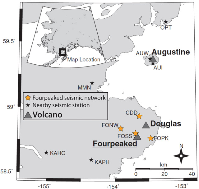 |
Figure 8. The seismic monitoring network of Fourpeaked volcano. Orange stars indicate the 4 short-period seismometers monitoring Fourpeaked; black stars indicate other nearby seismometers; triangles indicate volcanoes. Modified from Gardine and others (2011). |
November 2006-June 2007 activity. AVO reported that low level seismicity and persistent steaming (reaching up to several hundred meters above the summit) continued through the end of 2006. McGimsey and others (2011) reported that an airborne gas survey on 6 November 2006 showed continued elevated S02 emissions (~1,000 tons/day). The measured S02 flux measured soon after the 17 September eruption (figure 9) was more than 2,000 tons/day (McGimsey and others, 2011). In January 2007, AVO reported an earthquake swarm (swarm IV, figure 9), but stated that it was not considered unusual. Until 8 February, activity was typical of the past few months.
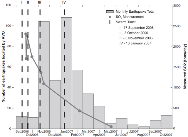 |
Figure 9. Recorded syn- and post-eruptive seismicity and S02 emissions at Fourpeaked volcano. Plots indicate the number of earthquakes per month (gray bars), timing of earthquake swarms (I-IV, vertical dashed black lines), and measured S02 emissions (tons/day, dark gray points and trend). The data extend 13 months following the 17 September 2006 phreatic eruption (swarm I). Courtesy of Gardine and others (2011). |
Beginning on 8 February 2007, AVO reported small explosive events that were registered on seismic and acoustic instruments, and a possible large steam plume that was noticed in a partly cloudy satellite view. A swarm of 13 locatable earthquakes occurred on 18 February, the largest of which was an M 1.8 event at ~4 km deep; this was the largest seismic event of the 2006-2007 Fourpeaked activity (McGimsey and others, 2011). A gas overflight on 22 February recorded S02 flux values below those measured in November.
Occasional small eruptions continued through March 2007, while seismicity gradually decreased (McGimsey and others 2011). In the last week of March, AVO reported decreased steam emissions from the vents at the summit. Explosive activity and declining gas emissions continued throughout April, and on 18 May, an aerial gas measurement revealed that the S02 flux had decreased to less than 90% of the measured values in September 2006 (Cervelli and West, 2007).
On 6 June 2007, citing declining seismicity and gas emissions, AVO lowered the Aviation Color Code from Yellow to Green, and the Volcanic Activity Alert Level from Advisory to Normal. They noted that "local hazards still [existed] near the summit, including jetting steam and/or very small explosions, unstable snow and ice, hot water and rock, and the possibility for high concentrations of dangerous volcanic gas."
Magma intrusion. Gardine and others (2011) analyzed seismic and gas emission data from the 2006-2007 Fourpeaked eruption and unrest (figure 9) in order to constrain the origin of the eruptive activity. Their findings suggested that the high levels of seismicity and gas emissions during the initial unrest indicated the intrusion of new magma into the upper 10 km of crust. They suggested that the intrusion reactivated fractures, allowing gases exsolved from the magma to be released at the surface. They argued that continued exsolution provided the gases released during the period of unrest, while local stress accumulation led to earthquake swarms (figure 9). They also suggested that the activity ceased only after the magma had cooled and degassed to a point where it became trapped and could no longer overcome the overburden pressure.
References. Cervelli, P.F. and West, M., 2007, The 2006 Eruption of Fourpeaked Volcano, Katmai National Park, Alaska, American Geophysical Union, Fall Meeting 2007, abstract ##V31E-0719.
Gardine, M., West, M., Werner, C., and Doukas, M., 2011, Evidence of magma intrusion at Fourpeaked volcano, Alaska in 2006-2007 from a rapid-response seismic network and volcanic gases, Journal of Volcanology and Geothermal Research, v. 200, issues 3-4, p. 192-200 (DOI: 10.1016/j.jvolgeores.2010.11.018).
McGimsey, R.G., Neal, C.A., Dixon, J.P., Malik, N., and Chibisova, M., 2011, 2007 Volcanic Activity in Alaska, Kamchatka, and the Kurile Islands: Summary of Events and Response of the Alaska Volcano Observatory, US Geological Society Scientific Investigations Report 2010-5242, 103 p.
Information Contacts: Alaska Volcano Observatory (AVO), a cooperative program of a) U.S. Geological Survey (USGS), 4200 University Drive, Anchorage, AK 99508-4667 USA (URL: http://www.avo.alaska.edu/), b) Geophysical Institute, University of Alaska, PO Box 757320, Fairbanks, AK 99775-7320, USA, and c) Alaska Division of Geological & Geophysical Surveys (ADGGS), 794 University Ave., Suite 200, Fairbanks, AK 99709, USA (URL: http://www.dggs.alaska.gov/).
2007: June
2006: September
| October
AVO reported that on 6 June the Volcanic Activity Alert Level for Fourpeaked was lowered from Advisory to Normal and the Aviation Color Code was lowered from Yellow to Green based on declining rates of seismicity and gas emission.
Source: US Geological Survey Alaska Volcano Observatory (AVO)
The AVO reported that earthquake activity and gas emissions continued at Fourpeaked during 14-20 October. Steam-and-gas plumes rising from a location near the summit were visible on a recently installed web camera.
Source: US Geological Survey Alaska Volcano Observatory (AVO)
The AVO reported that earthquake activity and gas emissions continued at Fourpeaked during 7-13 October. Observations through most of the week were hindered due to cloud cover, but on 12 October AVO staff reported that two prominent vents were emitting steam and gas.
Source: US Geological Survey Alaska Volcano Observatory (AVO)
The AVO reported that volcanic unrest continued at Fourpeaked during 30 September-6 October. A seismometer that was installed on 25 September indicated ongoing low-level seismicity. Due to the limited number of seismometers, earthquake epicenters were not located. Emission rates of sulfur dioxide were high, similar to the previous week.
Source: US Geological Survey Alaska Volcano Observatory (AVO)
Volcanic unrest continued at Fourpeaked volcano during 23-29 September. Satellite observations by scientists from the University of Maryland-Baltimore County indicate that sulfur dioxide emission was continuing. Early in the week, AVO conducted several helicopter and fixed-wing missions during which observers photographed a linear series of vents running N from the summit for about 1 km. Some of the vents were vigorously emitting steam and other volcanic gases. Thermal measurements of up to 75°C were recorded at the vents, although steam was likely obscuring hotter areas. Adjacent glacial ice had been disrupted and showed signs of subsidence. Airborne gas measurements taken on 23, 24, and 30 September documented high emission rates of sulfur dioxide, hydrogren sulfide, and carbon dioxide, and a distinct sulfur smell was evident up to 50 km from the summit. An AVO status report on 3 October noted that cloudy conditions had prevented visual or satellite observations, but limited seismic data now being received did not indicate significant volcanic activity.
Source: US Geological Survey Alaska Volcano Observatory (AVO)
On the evening of 17 September the Alaska Volcano Observatory (AVO) received several reports of two discrete plumes rising from the Cape Douglas area, about 320 km SW of Anchorage. Retrospective analysis of data from the NEXRAD Doppler radar in King Salmon showed an unusual cloud starting at 1200 that day. The maximum cloud height determined by radar during the first hour of the event was 6 km (20,000 ft) a.s.l. The radar return from the cloud continued until at least 2145. A cloud of sulfur dioxide gas was observed by colleagues at the University of Maryland Baltimore County over the Cape Douglas/Fourpeaked region at 1500 using data collected by the Ozone Monitoring Instrument (OMI) on NASA's Aura satellite. On this basis all of the clouds were inferred to be volcanic in origin. Although satellite data did not detect ash during this event, AVO received reports of a trace of ashfall at Nonvianuk Lake outlet (110 km WNW) and near Homer (150 km NE).
Both fixed-wing and helicopter overflights in the Cape Douglas area 20 September confirmed the source of volcanic activity to be Fourpeaked volcano. AVO raised the Level of Concern Color Code from "Not Assigned" to YELLOW on 20 September. Fourpeaked and Douglas volcanoes are not monitored seismically. A 23 September observation flight conducted in relatively good weather permitted the first look at the summit since the event of 17 September. Observers saw a linear series of vents running N from the summit for about 1 km. Most of these vents were vigorously emitting steam and other volcanic gases. Gas measurements indicated abundant quantities of sulfur dioxide, hydrogren sulfide, and carbon dioxide.
Source: US Geological Survey Alaska Volcano Observatory (AVO)
Reports are organized chronologically and indexed below by Month/Year (Publication Volume:Number), and include a one-line summary. Click on the index link or scroll down to read the reports.
Eruption on 17 September, followed by emissions until at least early November
Until the eruption of Fourpeaked on 17 September, evidence for eruptive activity in the past 10,000 years was uncertain. The volcano is largely glacier covered with only isolated outcrops (figure 1). This report discusses the initial observation of plumes and subsequent activity until the end of October 2006. Fourpeaked is in S Alaska ~ 320 km SW of Anchorage. It is SW of the mouth of Cook Inlet and within NE Katmai National Park (figure 2).
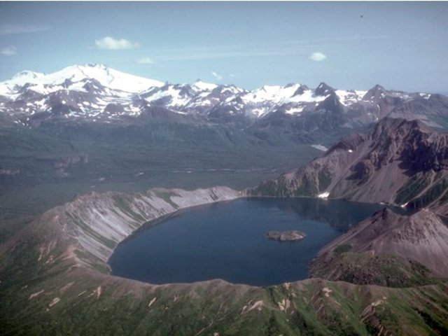 |
Figure 1. Fourpeaked volcano, the glacier-covered peak at the upper left is one of a group of poorly known volcanoes NE of Katmai National Park. In the foreground of this photo is Kaguyak caldera, which hosts a 2.5-km- wide lake. Pre-eruption photo at uncertain date taken by Chris Nye (Alaska Division of Geological and Geophysical Surveys, Alaska Volcano Observatory. |
 |
Figure 2. A map showing the location of Fourpeaked and Douglas volcanoes, Cook Inlet, and adjacent settlements including the city of Homer on the SW Kenai Peninsula. Created by Seth Snedigar and Janet Schaafer, AVO-ADGGS. |
On the evening of 17 September, AVO received several reports of two discrete plumes rising from the Cape Douglas area. The plumes were photographed at an unstated time on 17 September from the town of Homer (figure 3). At this stage, neither Douglas nor Fourpeaked had devoted seismic instruments.
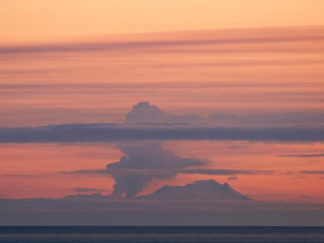 |
Figure 3. A photograph of the eruption of Fourpeaked on 17 September 2006. The photo was taken from Main Street in Homer at an unstated time. Copyrighted photograph by Lanny Simpson, Alaska High Mountain Images (shown on AVO's website). |
Retrospective analysis of data from the NEXRAD Doppler radar in King Salmon showed an unusual cloud starting at 1200 on 17 September. The maximum cloud height determined by radar during the first hour of the event was 6 km altitude. The radar return from the cloud continued until at least 2145 (figure 4).
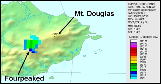 |
Figure 4. Image from the King Salmon NEXRAD weather radar showing the volcanic cloud at Fourpeaked on 17 September 2006 at 1240 (2040 UTC). In color the radar reflectivity ranges from light blue (low) to dark green (moderate), which corresponds to greater numbers and/or sizes of particles. It cannot be determined whether the signal is due to large water droplets, ice particles, coarse-grained ash, or a mixture. Image created by Dave Schneider, AVO/USGS, using data and software from the NOAA National Climatic Data Center. |
A cloud of sulfur dioxide gas was observed by colleagues at the Volcanic Emissions Group at the University of Maryland Baltimore. They used data collected at 1500 by the Ozone Monitoring Instrument (OMI) on NASA's Aura satellite (figure 5).
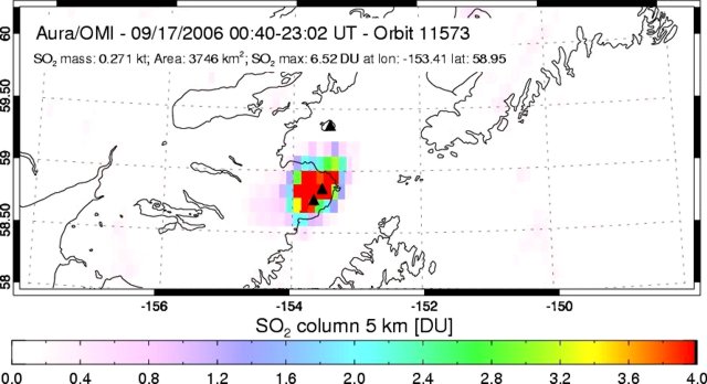 |
Figure 5. Image showing the total amount of sulfur dioxide over Fourpeaked on 17 September 2006 as measured by the Ozone Monitoring Instrument on NASA's Aura satellite. Sulfur dioxide is displayed in Dobson Units (DU, a measure of the number of molecules in a unit area of the atmospheric column). Image created by the Volcanic Emissions Group at the University of Maryland Baltimore County. |
On the basis of the suite of visual, radar, and satellite observations, all the 17 September clouds were inferred volcanic in origin. Although satellite data did not detect ash during this event, AVO received reports of a trace of ashfall at Nonvianuk Lake outlet (110 km WNW) and near Homer (150 km NE). Field observers saw deep scouring of a glacier flowing W from the summit, indicating flooding, probably from the 17 September event.In the caption to a 20 September AVO photo by K.L. Wallace there was noted a "continuous layer of discolored snow and ice above [~1 km elevation,]~3,000 feet asl on the NE flank of Fourpeaked volcano (S of Douglas volcano). Could possibly be ash from the 9/17/06 event."
Both fixed-wing and helicopter overflights in the Cape Douglas area on 20 September confirmed the source of volcanic activity to be Fourpeaked volcano. AVO raised the Level of Concern Color Code from "Not Assigned" to YELLOW on 20 September.
A 23 September observation flight conducted in relatively good weather permitted the first look at the summit since the event of 17 September. Observers saw a linear series of vents running N from the summit for about 1 km. Most of these vents vigorously emitted steam and other volcanic gases. Gas measurements indicated abundant quantities of sulfur dioxide, hydrogen sulfide, and carbon dioxide. Thermal measurements of up to 75°C were recorded at the vents, although steam was likely obscuring hotter areas. Adjacent glacial ice had been disrupted and showed signs of subsidence. Airborne gas measurements taken on 23, 24, and 30 September again documented high emission rates of sulfur dioxide, hydrogen sulfide, and carbon dioxide, and a distinct sulfur smell was evident up to 50 km from the summit. An AVO status report on 3 October noted that cloudy conditions had prevented visual or satellite observations, but limited seismic data being received did not indicate significant volcanic activity.
The AVO reported that volcanic unrest continued at Fourpeaked during 30 September-24 October. A seismometer installed on 25 September indicated ongoing low-level seismicity. Due to the limited number of seismometers, earthquake epicenters were not located. Emission rates of sulfur dioxide were high during 4-10 October and on 27 October. Observations were hindered due to cloud cover, but on 12 October AVO staff reported that two prominent vents were emitting steam and gas. Figure 6 shows several shots illustrating the enlarged opening in the ice on 15 October.
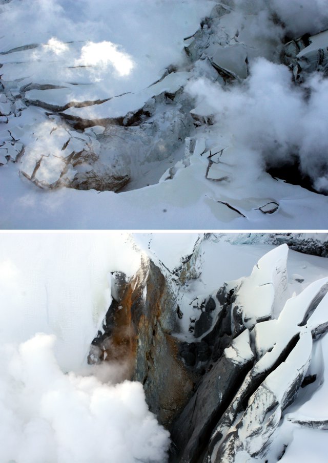 |
Figure 6. Photographs of the steaming vent area at Fourpeaked volcano on 15 October 2006. Courtesy of Kate Bull (AVO-ADGGS). |
On 20 October, field crews installed a web camera located 16 km (10 miles) N of Fourpeaked. Steam plumes originating from vents along the summit were visible via the web camera on 27 and 30 October. Steaming continued through at least 4 November (figure 7).
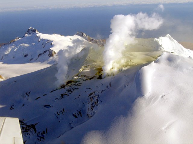 |
Figure 7. A 4 November 2006 photograph documenting steaming on the uppermost section of the northern flank of Fourpeaked volcano. Courtesy of Jennifer Adleman (AVO/USGS). |
Information Contacts: Alaska Volcano Observatory (AVO), a cooperative program of the U.S. Geological Survey, 4200 University Drive, Anchorage, AK 99508-4667, USA; Geophysical Institute, University of Alaska, PO Box 757320, Fairbanks, AK 99775-7320, USA; and Alaska Division of Geological & Geophysical Surveys, 794 University Ave., Suite 200, Fairbanks, AK 99709, USA (URL: http://www.avo.alaska.edu/); S.A. Carn, N.A. Krotkov, A.J. Krueger, and K. Yang, Joint Center for Earth Systems Technology (JCET), University of Maryland Baltimore County (UMBC), 1000 Hilltop Circle, Baltimore, MD 21250, USA.
Syn- and post-eruptive seismicity and emissions; magma intrusion model
Following the 17 September 2006 phreatic eruption of Fourpeaked volcano and subsequent non-juvenile ash emissions and debris flows (Cervelli and West, 2007; BGVN 31:09), low level seismicity (up to M 1.8) and emissions (S02 fluxes up to almost 3,000 tons/day) continued during late 2006 and the first half of 2007. Small explosions occurred during February-April 2007 amidst declining gas emissions. The Alaska Volcano Observatory (AVO) lowered the Aviation Color Code and Volcano Alert Level from Yellow/Advisory to Green/Normal on 6 June 2007 (on a scale from Green/Normal to Red/Warning).
Seismic monitoring network. Prior to the 2006-2007 eruption and unrest, Fourpeaked lacked a monitoring network (BGVN 31:09). A network of monitoring instruments was deployed in stages following the onset of unrest in 2006 (figure 8). The network consisted of 4 short-period seismometers (3 newly-deployed and 1 pre-existing), 2 co-located pressure sensors, and a web camera. As a result of the stepwise deployment of the instruments, the precision and number of earthquakes successfully located by AVO increased during the active period. Following the network's successful operation through the winter of 2006-2007, Fourpeaked was formally recognized as the 31st seismically monitored Alaskan volcano on 3 May 2007.
|
Figure 8. The seismic monitoring network of Fourpeaked volcano. Orange stars indicate the 4 short-period seismometers monitoring Fourpeaked; black stars indicate other nearby seismometers; triangles indicate volcanoes. Modified from Gardine and others (2011). |
November 2006-June 2007 activity. AVO reported that low level seismicity and persistent steaming (reaching up to several hundred meters above the summit) continued through the end of 2006. McGimsey and others (2011) reported that an airborne gas survey on 6 November 2006 showed continued elevated S02 emissions (~1,000 tons/day). The measured S02 flux measured soon after the 17 September eruption (figure 9) was more than 2,000 tons/day (McGimsey and others, 2011). In January 2007, AVO reported an earthquake swarm (swarm IV, figure 9), but stated that it was not considered unusual. Until 8 February, activity was typical of the past few months.
|
Figure 9. Recorded syn- and post-eruptive seismicity and S02 emissions at Fourpeaked volcano. Plots indicate the number of earthquakes per month (gray bars), timing of earthquake swarms (I-IV, vertical dashed black lines), and measured S02 emissions (tons/day, dark gray points and trend). The data extend 13 months following the 17 September 2006 phreatic eruption (swarm I). Courtesy of Gardine and others (2011). |
Beginning on 8 February 2007, AVO reported small explosive events that were registered on seismic and acoustic instruments, and a possible large steam plume that was noticed in a partly cloudy satellite view. A swarm of 13 locatable earthquakes occurred on 18 February, the largest of which was an M 1.8 event at ~4 km deep; this was the largest seismic event of the 2006-2007 Fourpeaked activity (McGimsey and others, 2011). A gas overflight on 22 February recorded S02 flux values below those measured in November.
Occasional small eruptions continued through March 2007, while seismicity gradually decreased (McGimsey and others 2011). In the last week of March, AVO reported decreased steam emissions from the vents at the summit. Explosive activity and declining gas emissions continued throughout April, and on 18 May, an aerial gas measurement revealed that the S02 flux had decreased to less than 90% of the measured values in September 2006 (Cervelli and West, 2007).
On 6 June 2007, citing declining seismicity and gas emissions, AVO lowered the Aviation Color Code from Yellow to Green, and the Volcanic Activity Alert Level from Advisory to Normal. They noted that "local hazards still [existed] near the summit, including jetting steam and/or very small explosions, unstable snow and ice, hot water and rock, and the possibility for high concentrations of dangerous volcanic gas."
Magma intrusion. Gardine and others (2011) analyzed seismic and gas emission data from the 2006-2007 Fourpeaked eruption and unrest (figure 9) in order to constrain the origin of the eruptive activity. Their findings suggested that the high levels of seismicity and gas emissions during the initial unrest indicated the intrusion of new magma into the upper 10 km of crust. They suggested that the intrusion reactivated fractures, allowing gases exsolved from the magma to be released at the surface. They argued that continued exsolution provided the gases released during the period of unrest, while local stress accumulation led to earthquake swarms (figure 9). They also suggested that the activity ceased only after the magma had cooled and degassed to a point where it became trapped and could no longer overcome the overburden pressure.
References. Cervelli, P.F. and West, M., 2007, The 2006 Eruption of Fourpeaked Volcano, Katmai National Park, Alaska, American Geophysical Union, Fall Meeting 2007, abstract ##V31E-0719.
Gardine, M., West, M., Werner, C., and Doukas, M., 2011, Evidence of magma intrusion at Fourpeaked volcano, Alaska in 2006-2007 from a rapid-response seismic network and volcanic gases, Journal of Volcanology and Geothermal Research, v. 200, issues 3-4, p. 192-200 (DOI: 10.1016/j.jvolgeores.2010.11.018).
McGimsey, R.G., Neal, C.A., Dixon, J.P., Malik, N., and Chibisova, M., 2011, 2007 Volcanic Activity in Alaska, Kamchatka, and the Kurile Islands: Summary of Events and Response of the Alaska Volcano Observatory, US Geological Society Scientific Investigations Report 2010-5242, 103 p.
Information Contacts: Alaska Volcano Observatory (AVO), a cooperative program of a) U.S. Geological Survey (USGS), 4200 University Drive, Anchorage, AK 99508-4667 USA (URL: http://www.avo.alaska.edu/), b) Geophysical Institute, University of Alaska, PO Box 757320, Fairbanks, AK 99775-7320, USA, and c) Alaska Division of Geological & Geophysical Surveys (ADGGS), 794 University Ave., Suite 200, Fairbanks, AK 99709, USA (URL: http://www.dggs.alaska.gov/).
This compilation of synonyms and subsidiary features may not be comprehensive. Features are organized into four major categories: Cones, Craters, Domes, and Thermal Features. Synonyms of features appear indented below the primary name. In some cases additional feature type, elevation, or location details are provided.
Synonyms |
| Gora Chetierek Glavaia | Tapirag, Mount | St. Dolmat | Four Peaks, Island of the | Saint Dolmat |
|
|
||||||||||||||||||||||||
There is data available for 1 confirmed Holocene eruptive periods.
2006 Sep 17 - 2006 Sep 17 Confirmed Eruption Max VEI: 2
| Episode 1 | Eruption Episode | Fissure trending N from summit | |||||||||||||||||||||||||||||
|---|---|---|---|---|---|---|---|---|---|---|---|---|---|---|---|---|---|---|---|---|---|---|---|---|---|---|---|---|---|---|
| 2006 Sep 17 - 2006 Sep 17 | Evidence from Observations: Reported | |||||||||||||||||||||||||||||
|
List of 4 Events for Episode 1 at Fissure trending N from summit
| ||||||||||||||||||||||||||||||
There is data available for 1 deformation periods. Expand each entry for additional details.
| Start Date: 2005 | Stop Date: 2010 | Direction: Uplift | Method: InSAR |
| Magnitude: 6.000 cm | Spatial Extent: 15.00 km | Latitude: 59.000 | Longitude: -154.000 |
Remarks: An uplift signal between Fourpeaked and Douglas is either due to magma or isostatic rebound. | |||
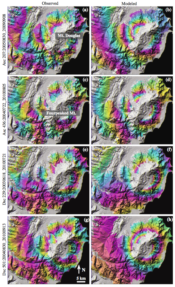 |
(Left column) Observed (a, c, e, g) deformation images of Fourpeaked and Douglas volcanoes from four InSAR images from four different tracks. (Right column) Modeled (b, d, f, h) deformation images for the corresponding interferograms in the left column, showing LOS displacements predicted by a Mogi source located *7 km BSL. A full cycle of colors (i.e., one interferometric fringe) represents 28 mm of LOS surface displacement. Areas of loss of InSAR coherence are not colored From: Lu and Dzurisin 2014. |
||
Reference List: Lu and Dzurisin 2014.
Full References:
Lu Z, Dzurisin D, 2014. InSAR imaging of Aleutian volcanoes: monitoring a volcanic arc from space. Springer-Verlag Berlin Heidelberg. https://doi.org/10.1007/978-3-642-00348-6
There is data available for 1 emission periods. Expand each entry for additional details.
| Start Date: 2006 Sep 17 | Stop Date: 2006 Sep 17 | Method: Satellite (Aura OMI) |
| SO2 Altitude Min: 6 km | SO2 Altitude Max: 6 km | Total SO2 Mass: 1 kt |
Data Details
| Date Start | Date End | Assumed SO2 Altitude | SO2 Algorithm | SO2 Mass |
| 20060917 | 6.0 | 1.000 |
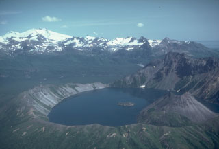 Fourpeaked volcano to the upper left is one of a group of volcanoes NE of Katmai National Park, beyond the 2.5-km-wide Kaguyak caldera in the foreground. Much of the surface is hidden beneath Fourpeaked Glacier; the few exposed outcrops are lava flows interlayered with volcanic agglomerate. Deposits near the summit are extensively hydrothermally altered.
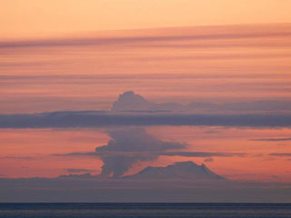 A plume rises above Fourpeaked during its first observed eruption, on 7 September 2006, as seen from Main Street in Homer, across Cook Inlet. The plume rose to a maximum height of 6 km and resulted in a trace of ashfall at Nonvianuk Lake outlet (110 km WNW) and near Homer (150 km NE). The eruption produced a 1-km-long fissure that extended north from the summit.
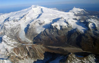 Glaciated Fourpeaked volcano in NE Katmai National Park is seen here from the south with the Swikshak River in the foreground. Holocene eruptions at Fourpeaked had not been confirmed prior to its first recorded eruption in September 2006.
The maps shown below have been scanned from the GVP map archives and include the volcano on this page. Clicking on the small images will load the full 300 dpi map. Very small-scale maps (such as world maps) are not included. The maps database originated over 30 years ago, but was only recently updated and connected to our main database. We welcome users to tell us if they see incorrect information or other problems with the maps; please use the Contact GVP link at the bottom of the page to send us email.
There are no samples for Fourpeaked in the Smithsonian's NMNH Department of Mineral Sciences Rock and Ore collection.
| Alaska Volcano Observatory (Link to Fourpeaked) | The Alaska Volcano Observatory (AVO) is a joint program of the U.S. Geological Survey (USGS), the Geophysical Institute of the University of Alaska Fairbanks (UAFGI), and the State of Alaska Division of Geological and Geophysical Surveys (ADGGS). AVO was formed in 1988, and uses federal, state, and university resources to monitor and study Alaska's hazardous volcanoes, to predict and record eruptive activity, and to mitigate volcanic hazards to life and property. |
| Copernicus Browser | The Copernicus Browser replaced the Sentinel Hub Playground browser in 2023, to provide access to Earth observation archives from the Copernicus Data Space Ecosystem, the main distribution platform for data from the EU Copernicus missions. |
| MIROVA | Middle InfraRed Observation of Volcanic Activity (MIROVA) is a near real time volcanic hot-spot detection system based on the analysis of MODIS (Moderate Resolution Imaging Spectroradiometer) data. In particular, MIROVA uses the Middle InfraRed Radiation (MIR), measured over target volcanoes, in order to detect, locate and measure the heat radiation sourced from volcanic activity. |
| MODVOLC Thermal Alerts | Using infrared satellite Moderate Resolution Imaging Spectroradiometer (MODIS) data, scientists at the Hawai'i Institute of Geophysics and Planetology, University of Hawai'i, developed an automated system called MODVOLC to map thermal hot-spots in near real time. For each MODIS image, the algorithm automatically scans each 1 km pixel within it to check for high-temperature hot-spots. When one is found the date, time, location, and intensity are recorded. MODIS looks at every square km of the Earth every 48 hours, once during the day and once during the night, and the presence of two MODIS sensors in space allows at least four hot-spot observations every two days. Each day updated global maps are compiled to display the locations of all hot spots detected in the previous 24 hours. There is a drop-down list with volcano names which allow users to 'zoom-in' and examine the distribution of hot-spots at a variety of spatial scales. |
|
WOVOdat
Single Volcano View Temporal Evolution of Unrest Side by Side Volcanoes |
WOVOdat is a database of volcanic unrest; instrumentally and visually recorded changes in seismicity, ground deformation, gas emission, and other parameters from their normal baselines. It is sponsored by the World Organization of Volcano Observatories (WOVO) and presently hosted at the Earth Observatory of Singapore.
GVMID Data on Volcano Monitoring Infrastructure The Global Volcano Monitoring Infrastructure Database GVMID, is aimed at documenting and improving capabilities of volcano monitoring from the ground and space. GVMID should provide a snapshot and baseline view of the techniques and instrumentation that are in place at various volcanoes, which can be use by volcano observatories as reference to setup new monitoring system or improving networks at a specific volcano. These data will allow identification of what monitoring gaps exist, which can be then targeted by remote sensing infrastructure and future instrument deployments. |
| Volcanic Hazard Maps | The IAVCEI Commission on Volcanic Hazards and Risk has a Volcanic Hazard Maps database designed to serve as a resource for hazard mappers (or other interested parties) to explore how common issues in hazard map development have been addressed at different volcanoes, in different countries, for different hazards, and for different intended audiences. In addition to the comprehensive, searchable Volcanic Hazard Maps Database, this website contains information about diversity of volcanic hazard maps, illustrated using examples from the database. This site is for educational purposes related to volcanic hazard maps. Hazard maps found on this website should not be used for emergency purposes. For the most recent, official hazard map for a particular volcano, please seek out the proper institutional authorities on the matter. |
| IRIS seismic stations/networks | Incorporated Research Institutions for Seismology (IRIS) Data Services map showing the location of seismic stations from all available networks (permanent or temporary) within a radius of 0.18° (about 20 km at mid-latitudes) from the given location of Fourpeaked. Users can customize a variety of filters and options in the left panel. Note that if there are no stations are known the map will default to show the entire world with a "No data matched request" error notice. |
| UNAVCO GPS/GNSS stations | Geodetic Data Services map from UNAVCO showing the location of GPS/GNSS stations from all available networks (permanent or temporary) within a radius of 20 km from the given location of Fourpeaked. Users can customize the data search based on station or network names, location, and time window. Requires Adobe Flash Player. |
| DECADE Data | The DECADE portal, still in the developmental stage, serves as an example of the proposed interoperability between The Smithsonian Institution's Global Volcanism Program, the Mapping Gas Emissions (MaGa) Database, and the EarthChem Geochemical Portal. The Deep Earth Carbon Degassing (DECADE) initiative seeks to use new and established technologies to determine accurate global fluxes of volcanic CO2 to the atmosphere, but installing CO2 monitoring networks on 20 of the world's 150 most actively degassing volcanoes. The group uses related laboratory-based studies (direct gas sampling and analysis, melt inclusions) to provide new data for direct degassing of deep earth carbon to the atmosphere. |
| Large Eruptions of Fourpeaked | Information about large Quaternary eruptions (VEI >= 4) is cataloged in the Large Magnitude Explosive Volcanic Eruptions (LaMEVE) database of the Volcano Global Risk Identification and Analysis Project (VOGRIPA). |
| EarthChem | EarthChem develops and maintains databases, software, and services that support the preservation, discovery, access and analysis of geochemical data, and facilitate their integration with the broad array of other available earth science parameters. EarthChem is operated by a joint team of disciplinary scientists, data scientists, data managers and information technology developers who are part of the NSF-funded data facility Integrated Earth Data Applications (IEDA). IEDA is a collaborative effort of EarthChem and the Marine Geoscience Data System (MGDS). |