Continued high fumarolic activity; clusters of hundred of new fumaroles
Card 2244 (07 August 1975) Continued high fumarolic activity; clusters of hundred of new fumaroles
All available evidence shows that the March increase in fumarolic activity at Mount Baker has not diminished and in some aspects has continued to increase. Since the initial ground investigation on 28 March, various university and federal scientists have installed instrumentation to begin intensive volcano monitoring.
Clusters of hundreds of new fumaroles have at least doubled the area of snow-free ground and have melted large ice pits in the normally glacier-filled Sherman Crater. Two of the new ice pits contain shallow lakes, one of which was 34°C on 11 June. Acid water from the lakes and from other snowmelt in the crater drains into the Boulder Creek valley on the east side of the volcano where water quality is presently monitored.
As ice cover in the crater melts, new clusters of fumaroles continue to appear. One main fumarole which was about 1 m in diameter in March has developed into a 1 x 5 m fissure. Accessible fumaroles have had temperatures at boiling, 90-91°C; but the main fumarole remains inaccessible. Continual ash emission from this as well as some of the other fumaroles has coated snow in the Sherman Crater area with a gray blanket at least 1 cm thick. Several analyses of the ash show it to be composed largely of secondary minerals, old rock fragments, and pyrite-covered sulfur droplets. A very small fraction of vesicular glass in some ash samples is currently thought to be reworked older material.
Continuously-telemetered seismic data from a station on the Sherman Crater rim and from a station at a lower elevation show intermittent variations in high-frequency background noise and a few local transient seismic events. No strong seismic trend has yet been detected. Furthermore, a hydrogen and temperature sensor, several tilt and gravity stations, and time-lapse cameras have not been in operation long enough to show definite trends. Additional monitoring includes aerial photographic, thermographic, and sulfur surveys.
The other large thermal area on Mount Baker, the Dorr fumarole field on the N side of the cone, has not yet shown significant changes in activity compared to previous years.
Information Contacts: David Frank, Quaternary Research Center, University of Washington; Stephen D. Malone, University of Washington.
The Global Volcanism Program has no Weekly Reports available for Baker.
Reports are organized chronologically and indexed below by Month/Year (Publication Volume:Number), and include a one-line summary. Click on the index link or scroll down to read the reports.
Increased fumarolic activity and new fumaroles
Card 2132 (28 March 1975) Increased fumarolic activity and new fumaroles
Reports were received beginning on the evening of 10 March 1975, of larger than normal amounts of vapor from Sherman Crater, which is known to have contained a fumarole field since the latter 1800's. Aerial photographs taken 11 March show two new clusters of fumaroles which perforate through snow and ice in Sherman Crater. Semi-circular crevasses in the crater were apparent and seemed to be related to ice subsidence.
A thin swath of gray debris, partly covered by new snow, extended 100-300 m outside the E, S, and W part of the crater rim. A small lake within one of the ice perforations was observed by air on 11 and 13 March. On 20 March, ground observers examined Boulder Creek, down valley from the drainage outlet of the Sherman Crater rim and reported no flooding but highly acidic (pH = 3.7) and sulfur-smelling water. Large amounts of steam were seen when the mountain again was visible on 24 March.
An interdisciplinary team of scientists is mobilizing to determine the significance of the new thermal activity.
Information Contacts: David Frank, University of Washington; Mark F. Miller, USGS.
New crater lake observed; significant melting
Card 2219 (14 July 1975) Aerial observations; new crater lake
A photo flight under dull, high overcast was made between 1500 and 1530 over Mt. Baker on 3 July 1975. Vertical photos with a K-17, 6" lens of Sherman Crater, Dorr Fumarole Field and later, McAllister, Klawatti, Boston, and South Cascade glaciers, plus numerous 35 mm oblique color views were taken.
Steam activity at the fumarole sites including Dorr Fumraole Field was the lowest we have observed in recent months, possibly due to atmospheric conditions. This allowed a close examination of many openings, particularly the E breach area of the crater, and here a new crater lake was observed in a large ice cavern located NE of the central pit about midway between the E breach and the N pit. The lake color was a muddy brown, in contrast to the pale green of the central lake. It appeared to be at least 20 m across, and of undetermined length. Most of the ice bridge covering the new lake appeared to be quite thick and ice encroaching from the N slope may delay its collapse for weeks or even months.
No new large openings were observed in the E breach area where the snow was completely covered with a heavy, continuous layer of brown/gray mud. The ice was melting away from the rocks on either side exposing openings which appeared to connect with the subglacial opening following the outlet stream, possibly due to thermal heat in the rocks. A crevasse near the head of Boulder Glacier, which probably spans the subglacial outlet stream from the crater, appeared to open into an extensive cavern below. No steam was observed from this potentially large opening.
Card 2227 (21 July 1975) Rapid melting of ice and snow
A photo flight with clear skies was made between 1530 and 1600 over Mt. Baker on 9 July 1975. The temperature at 4,000 m was +10°C and extremely rapid snow and ice melt was in progress; Glacier Creek in particular was a brown, raging flood. The effects of snow melt were very noticeable on the upper part of the mountain, seasonal snow having disappeared from most rock areas and last year's snow surface being exposed on areas subject to wind scour. Other evidence of very thin snow on the upper mountain was the reappearance of traces of the rim of the true Summit Crater in the Roman Wall vicinity, a feature which has been snow-covered when photographed later than in the 1940's.
In the six days since observing the mountain, changes in the Sherman Crater area were notable. Fragments of ice falling into the central pit covered most of the bottom and these either filled most of the lake or the lake had largely drained. The new lake observed 3 July was completely obscured by collapse of the entrance of the ice cavern in which it was located. No doubt due in part to the very rapid surface melting in progress, rocks within the crater recently exposed by sliding of the ice off the slopes were much more visible.
The most noteworthy change outside the crater was the collapse of the ice covering a cavity noted in a crevasse near the head of Boulder Glacier observed on 3 July. More important, although visible steam activity within the crater was low as on 3 July and the Dorr Fumarole Field was notable by a nearly complete absence of visible steam, fog-like vapor was observed in the highest crevasse on Boulder Glacier near the area of ice collapse. These together strongly suggest that a fumarole has developed in this critical area situated immediately below Sherman Peak and Lahar Lookout.
Information Contacts:
Card 2219 (14 July 1975) Austin Post, USGS.
Card 2227 (21 July 1975) Austin Post, USGS.
Continued high fumarolic activity; clusters of hundred of new fumaroles
Card 2244 (07 August 1975) Continued high fumarolic activity; clusters of hundred of new fumaroles
All available evidence shows that the March increase in fumarolic activity at Mount Baker has not diminished and in some aspects has continued to increase. Since the initial ground investigation on 28 March, various university and federal scientists have installed instrumentation to begin intensive volcano monitoring.
Clusters of hundreds of new fumaroles have at least doubled the area of snow-free ground and have melted large ice pits in the normally glacier-filled Sherman Crater. Two of the new ice pits contain shallow lakes, one of which was 34°C on 11 June. Acid water from the lakes and from other snowmelt in the crater drains into the Boulder Creek valley on the east side of the volcano where water quality is presently monitored.
As ice cover in the crater melts, new clusters of fumaroles continue to appear. One main fumarole which was about 1 m in diameter in March has developed into a 1 x 5 m fissure. Accessible fumaroles have had temperatures at boiling, 90-91°C; but the main fumarole remains inaccessible. Continual ash emission from this as well as some of the other fumaroles has coated snow in the Sherman Crater area with a gray blanket at least 1 cm thick. Several analyses of the ash show it to be composed largely of secondary minerals, old rock fragments, and pyrite-covered sulfur droplets. A very small fraction of vesicular glass in some ash samples is currently thought to be reworked older material.
Continuously-telemetered seismic data from a station on the Sherman Crater rim and from a station at a lower elevation show intermittent variations in high-frequency background noise and a few local transient seismic events. No strong seismic trend has yet been detected. Furthermore, a hydrogen and temperature sensor, several tilt and gravity stations, and time-lapse cameras have not been in operation long enough to show definite trends. Additional monitoring includes aerial photographic, thermographic, and sulfur surveys.
The other large thermal area on Mount Baker, the Dorr fumarole field on the N side of the cone, has not yet shown significant changes in activity compared to previous years.
Information Contacts: David Frank, Quaternary Research Center, University of Washington; Stephen D. Malone, University of Washington.
|
|
||||||||||||||||||||||||||||
There is data available for 11 confirmed Holocene eruptive periods.
[ 1884 ] Uncertain Eruption
| Episode 1 | Eruption (Explosive / Effusive) | Sherman Crater | ||||||||||||||
|---|---|---|---|---|---|---|---|---|---|---|---|---|---|---|---|
| 1884 - Unknown | Evidence from Unknown | ||||||||||||||
|
List of 1 Events for Episode 1 at Sherman Crater
|
|||||||||||||||
1880 Sep 7 - 1880 Nov 27 Confirmed Eruption (Explosive / Effusive) VEI: 2
| Episode 1 | Eruption (Explosive / Effusive) | Sherman Crater | ||||||||||||||||||||||||
|---|---|---|---|---|---|---|---|---|---|---|---|---|---|---|---|---|---|---|---|---|---|---|---|---|---|
| 1880 Sep 7 - 1880 Nov 27 | Evidence from Observations: Reported | ||||||||||||||||||||||||
|
List of 3 Events for Episode 1 at Sherman Crater
|
|||||||||||||||||||||||||
1870 Confirmed Eruption (Explosive / Effusive) VEI: 2
| Episode 1 | Eruption (Explosive / Effusive) | Sherman Crater | ||||||||||||||||||||||||
|---|---|---|---|---|---|---|---|---|---|---|---|---|---|---|---|---|---|---|---|---|---|---|---|---|---|
| 1870 - Unknown | Evidence from Observations: Reported | ||||||||||||||||||||||||
|
List of 3 Events for Episode 1 at Sherman Crater
|
|||||||||||||||||||||||||
[ 1869 Jun ] Uncertain Eruption
| Episode 1 | Eruption (Explosive / Effusive) | Sherman Crater | ||||||||||||||
|---|---|---|---|---|---|---|---|---|---|---|---|---|---|---|---|
| 1869 Jun - Unknown | Evidence from Unknown | ||||||||||||||
|
List of 1 Events for Episode 1 at Sherman Crater
|
|||||||||||||||
[ 1867 Mar ] Uncertain Eruption
| Episode 1 | Eruption (Explosive / Effusive) | Sherman Crater | ||||||||||||||
|---|---|---|---|---|---|---|---|---|---|---|---|---|---|---|---|
| 1867 Mar - Unknown | Evidence from Unknown | ||||||||||||||
|
List of 1 Events for Episode 1 at Sherman Crater
|
|||||||||||||||
[ 1865 ] Uncertain Eruption
| Episode 1 | Eruption (Explosive / Effusive) | Sherman Crater | ||||||||||||||
|---|---|---|---|---|---|---|---|---|---|---|---|---|---|---|---|
| 1865 - Unknown | Evidence from Unknown | ||||||||||||||
|
List of 1 Events for Episode 1 at Sherman Crater
|
|||||||||||||||
1863 Jul Confirmed Eruption (Explosive / Effusive) VEI: 2
| Episode 1 | Eruption (Explosive / Effusive) | Sherman Crater | ||||||||||||||||||||||||
|---|---|---|---|---|---|---|---|---|---|---|---|---|---|---|---|---|---|---|---|---|---|---|---|---|---|
| 1863 Jul - Unknown | Evidence from Observations: Reported | ||||||||||||||||||||||||
|
List of 3 Events for Episode 1 at Sherman Crater
|
|||||||||||||||||||||||||
[ 1860 Dec ] Uncertain Eruption
| Episode 1 | Eruption (Explosive / Effusive) | Sherman Crater | ||||||||||||||
|---|---|---|---|---|---|---|---|---|---|---|---|---|---|---|---|
| 1860 Dec - Unknown | Evidence from Unknown | ||||||||||||||
|
List of 1 Events for Episode 1 at Sherman Crater
|
|||||||||||||||
1859 Nov - 1860 Apr 26 (?) Confirmed Eruption (Explosive / Effusive) VEI: 2
| Episode 1 | Eruption (Explosive / Effusive) | Sherman Crater | |||||||||||||||||||||||||||||
|---|---|---|---|---|---|---|---|---|---|---|---|---|---|---|---|---|---|---|---|---|---|---|---|---|---|---|---|---|---|---|
| 1859 Nov - 1860 Apr 26 (?) | Evidence from Observations: Reported | |||||||||||||||||||||||||||||
|
List of 4 Events for Episode 1 at Sherman Crater
|
||||||||||||||||||||||||||||||
1858 Confirmed Eruption (Explosive / Effusive) VEI: 2
| Episode 1 | Eruption (Explosive / Effusive) | Sherman Crater | |||||||||||||||||||
|---|---|---|---|---|---|---|---|---|---|---|---|---|---|---|---|---|---|---|---|---|
| 1858 - Unknown | Evidence from Observations: Reported | |||||||||||||||||||
|
List of 2 Events for Episode 1 at Sherman Crater
|
||||||||||||||||||||
[ 1856 ] Uncertain Eruption
| Episode 1 | Eruption (Explosive / Effusive) | Sherman Crater | ||||||||||||||
|---|---|---|---|---|---|---|---|---|---|---|---|---|---|---|---|
| 1856 - Unknown | Evidence from Unknown | ||||||||||||||
|
List of 1 Events for Episode 1 at Sherman Crater
|
|||||||||||||||
1854 Confirmed Eruption (Explosive / Effusive) VEI: 2
| Episode 1 | Eruption (Explosive / Effusive) | Sherman Crater | ||||||||||||||||||||||||
|---|---|---|---|---|---|---|---|---|---|---|---|---|---|---|---|---|---|---|---|---|---|---|---|---|---|
| 1854 - Unknown | Evidence from Observations: Reported | ||||||||||||||||||||||||
|
List of 3 Events for Episode 1 at Sherman Crater
|
|||||||||||||||||||||||||
1852 Dec 1 ± 30 days - 1853 Jan (?) Confirmed Eruption (Explosive / Effusive) VEI: 2
| Episode 1 | Eruption (Explosive / Effusive) | Sherman Crater | ||||||||||||||||||||||||||||||||||
|---|---|---|---|---|---|---|---|---|---|---|---|---|---|---|---|---|---|---|---|---|---|---|---|---|---|---|---|---|---|---|---|---|---|---|---|
| 1852 Dec 1 ± 30 days - 1853 Jan (?) | Evidence from Observations: Reported | ||||||||||||||||||||||||||||||||||
|
List of 5 Events for Episode 1 at Sherman Crater
|
|||||||||||||||||||||||||||||||||||
[ 1850 Mar ] Uncertain Eruption
| Episode 1 | Eruption (Explosive / Effusive) | Sherman Crater | ||||||||||||||
|---|---|---|---|---|---|---|---|---|---|---|---|---|---|---|---|
| 1850 Mar - Unknown | Evidence from Unknown | ||||||||||||||
|
List of 1 Events for Episode 1 at Sherman Crater
|
|||||||||||||||
[ 1846 ] Uncertain Eruption
| Episode 1 | Eruption (Explosive / Effusive) | |||||||||||||||
|---|---|---|---|---|---|---|---|---|---|---|---|---|---|---|---|
| 1846 - Unknown | Evidence from Unknown | ||||||||||||||
|
List of 1 Events for Episode 1
|
|||||||||||||||
1843 Confirmed Eruption (Explosive / Effusive) VEI: 3 (?)
| Episode 1 | Eruption (Explosive / Effusive) | Sherman Crater | ||||||||||||||||||||||||||||||||||
|---|---|---|---|---|---|---|---|---|---|---|---|---|---|---|---|---|---|---|---|---|---|---|---|---|---|---|---|---|---|---|---|---|---|---|---|
| 1843 - Unknown | Evidence from Observations: Reported | ||||||||||||||||||||||||||||||||||
|
List of 5 Events for Episode 1 at Sherman Crater
|
|||||||||||||||||||||||||||||||||||
1820 (?) Confirmed Eruption (Explosive / Effusive) VEI: 2
| Episode 1 | Eruption (Explosive / Effusive) | |||||||||||||||||||||||||||||||||||
|---|---|---|---|---|---|---|---|---|---|---|---|---|---|---|---|---|---|---|---|---|---|---|---|---|---|---|---|---|---|---|---|---|---|---|---|
| 1820 (?) - Unknown | Evidence from Observations: Reported | ||||||||||||||||||||||||||||||||||
|
List of 5 Events for Episode 1
|
|||||||||||||||||||||||||||||||||||
[ 1792 Jun ] Uncertain Eruption
| Episode 1 | Eruption (Explosive / Effusive) | |||||||||||||||
|---|---|---|---|---|---|---|---|---|---|---|---|---|---|---|---|
| 1792 Jun - Unknown | Evidence from Unknown | ||||||||||||||
|
List of 1 Events for Episode 1
|
|||||||||||||||
4550 BCE (?) Confirmed Eruption (Explosive / Effusive) VEI: 3 (?)
| Episode 1 | Eruption (Explosive / Effusive) | Sherman Crater? | ||||||||||||||||||||||||||||||||||||||||||||||||||||||
|---|---|---|---|---|---|---|---|---|---|---|---|---|---|---|---|---|---|---|---|---|---|---|---|---|---|---|---|---|---|---|---|---|---|---|---|---|---|---|---|---|---|---|---|---|---|---|---|---|---|---|---|---|---|---|---|
| 4550 BCE (?) - Unknown | Evidence from Isotopic: 14C (calibrated) | ||||||||||||||||||||||||||||||||||||||||||||||||||||||
|
List of 9 Events for Episode 1 at Sherman Crater?
|
|||||||||||||||||||||||||||||||||||||||||||||||||||||||
7850 BCE (?) Confirmed Eruption (Explosive / Effusive)
| Episode 1 | Eruption (Explosive / Effusive) | South flank (Schreibers Meadow Cone) | ||||||||||||||||||||||||
|---|---|---|---|---|---|---|---|---|---|---|---|---|---|---|---|---|---|---|---|---|---|---|---|---|---|
| 7850 BCE (?) - Unknown | Evidence from Isotopic: 14C (calibrated) | ||||||||||||||||||||||||
|
List of 3 Events for Episode 1 at South flank (Schreibers Meadow Cone)
|
|||||||||||||||||||||||||
This compilation of synonyms and subsidiary features may not be comprehensive. Features are organized into four major categories: Cones, Craters, Domes, and Thermal Features. Synonyms of features appear indented below the primary name. In some cases additional feature type, elevation, or location details are provided.
Synonyms |
||||
| Koma Kulshan | Kulshan | Carmelo, la montana del | Quick-Sman-Ik | Tukullum | Puk'h'kowitz | ||||
Cones |
||||
| Feature Name | Feature Type | Elevation | Latitude | Longitude |
| Black Buttes | Stratovolcano | 2875 m | 48° 46' 18.00" N | 121° 50' 33.00" W |
| Chowder Ridge | Stratovolcano | 2291 m | 48° 48' 51.00" N | 121° 49' 16.00" W |
| Landes Cleaver | Vent | 2110 m | 48° 48' 12.00" N | 121° 47' 1.00" W |
| Lava Divide | Stratovolcano | 2175 m | 48° 47' 36.00" N | 121° 47' 7.00" W |
| Schreibers Meadow Cone | Pyroclastic cone | 1110 m | 48° 41' 57.00" N | 121° 49' 2.00" W |
Craters |
||||
| Feature Name | Feature Type | Elevation | Latitude | Longitude |
| Carmelo Crater | Crater | 3285 m | 48° 46' 36.00" N | 121° 48' 47.00" W |
| Kulshan Caldera | Pleistocene caldera | 1988 m | 48° 50' 0.00" N | 121° 43' 0.00" W |
| Sherman Crater | Crater | 2900 m | 48° 46' 0.00" N | 121° 49' 0.00" W |
Thermal |
||||
| Feature Name | Feature Type | Elevation | Latitude | Longitude |
| Baker Hot Springs | Hot Spring | 490 m | 48° 46' 0.00" N | 121° 40' 0.00" W |
| Dorr Fumarole Field | Fumarole | 2400 m | ||
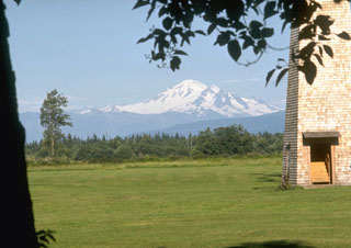 Mount Baker, seen here from the dairy farms of Whatcom County to the west, is a prominent landmark visible from much of NW Washington and SW British Columbia. Nineteenth-century eruptions were visible from as far away as Victoria Island across the Puget Sound.
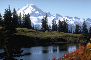 Glaciated Mount Baker is seen here from Twin Lakes to the north. Sherman Crater, the source of historical eruptions from Mount Baker, is visible on the left side between the summit and the smaller Sherman Peak. The older eroded Black Buttes volcano forms the two peaks below and to the right of the summit.
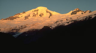 Mount Baker is seen here from the Glacier Creek valley on the NW side. Coleman Glacier is in the right-center of the photo with Coleman Saddle located between the summit and Colfax Peak on the right. The active Sherman Crater is on the opposite SE side of the summit.
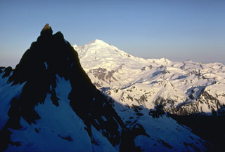 The glaciated surface of Mount Baker is seen here from neighboring Mount Shuksan. The peak in the shadow consists of metamorphosed basaltic rocks of the Shuksan Greenschist. The area to the right is the recently discovered Pleistocene Kulshan Caldera, which preceded the construction of Mount Baker. The 4.5 x 8 km caldera is largely filled by up to 1 km of non-welded tuffs and is capped by lava flows.
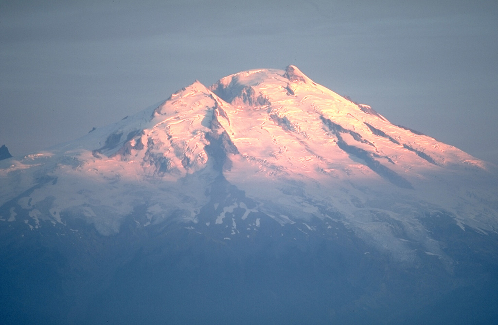
 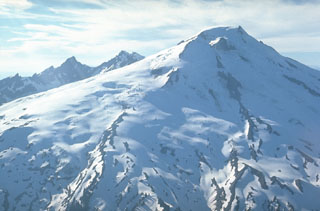 This view from the SE shows the extensive glacial cover on Mount Baker in 1972. Twelve glaciers cover the volcano with 114 km2 of ice, which is the largest glacial icecap of any Cascade volcano, including Mount Rainier. Part of Sherman Crater, the historically active vent, is lit by the sun just below the summit, to the right of Sherman Peak. The eroded Black Buttes volcano is in the background.
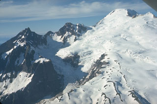 This view from the SW shows the Deming Glacier below Lincoln (left) and Colfax Peaks, which are remnants of the Pleistocene Black Buttes volcano that once stood where Mount Baker is now. Lavas from Black Buttes, which was active from about 500,000 to 300,000 years ago, dip towards Mount Baker with its flat-topped summit (upper right). Easton Glacier is on the S flank.
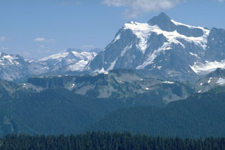 The flat-topped ridge in the center of this photo is Table Mountain, seen here from Skyline Divide. Table Mountain is a stack of andesitic lava flows, each about 100 m thick, that erupted from vents along the northern side of the Pleistocene Kulshan caldera. The buried northern caldera rim lies near the left-hand margin of the lava flows. The spectacular glacier-clad slopes of Mt. Shuksan form the right horizon, and Icy Peak at the head of the North Fork Nooksack drainage lies beyond it on the left-center horizon.
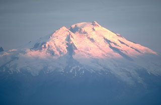 The glaciated Mount Baker is the northernmost of Washington's active volcanoes in the northern Cascade Range, seen here from the SE above Baker Lake. Historical eruptions have originated from Sherman Crater to the left of the summit. Minor phreatic explosions were observed during the 19th century by early settlers in the Puget Sound area as far away as Victoria, British Columbia.
 The forested scoria cone in the left of the photo is Schreibers Meadow Cone on the SE flank of Mount Baker. It erupted about 9,800 years ago, producing a scoria deposit and a lava flow that traveled 12 km to the present location of Baker Lake. The ridge in the foreground is a glacial moraine from Mount Baker known as the "Railroad Grade."
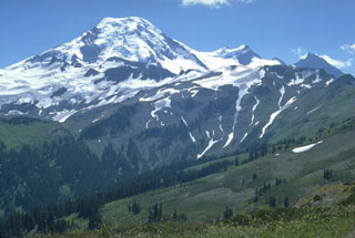 The north flank of Mount Baker is seen from Skyline Divide with the two peaks of the Pleistocene Black Buttes on the right horizon. Chowder Ridge extends across the middle of the image in front of Black Buttes towards Mt. Hadley, the peak below the flat-topped Mount Baker summit. The ridge is named for its marine brachiopod fossils and contains numerous dikes, the feeders for a large early and mid-Pleistocene volcanic center that has been almost entirely eroded away by Pleistocene continental ice sheets.
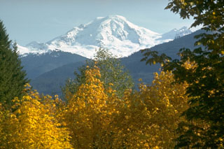 Glaciated Mount Baker rises above the North Fork Nooksack River valley below the NW flank.
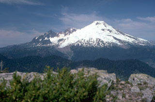 Mount Baker in the northern Cascades rises 1,500 m above a dissected basement complex of metamorphic and sedimentary rocks, exposed at Dock Butte in the foreground. On the left skyline is the glacially eroded core of the Pleistocene Black Buttes stratovolcano, a predecessor to Mount Baker. From left to right, the Deming, Easton, Squock, Talum, Boulder, and Park Glaciers drape the volcano's flanks.
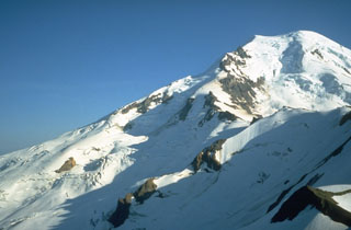 The north flank of Mount Baker towers above Cockscomb Ridge, with the Roosevelt Glacier descending from the summit. The Dole Fumarole Field on the northern flank is located below a point around halfway down the left-hand horizon, near where the shadow line on the Mazama Glacier (center) takes a sharp bend. William Henry Dorr reported vapor emission at this location in 1884 and fumarolic activity continues today.
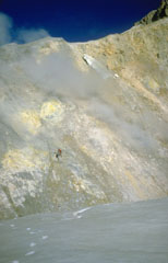 Two U.S. Geological Survey volcanologists (left center) take gas samples from a fumarole, one of many across the wall of Sherman Crater in 1981. Increased emissions had begun from Sherman Crater in 1975. The crater walls consist of brightly colored areas of hydrothermally altered rocks.
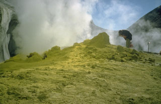 A geologist examines a fumarole surrounded by sulfur mineralization at Sherman Crater in 1981. Greatly increased thermal emission beginning in 1975 melted glacial ice in Sherman Crater and created many new fumaroles. Plumes are occasionally visible from the Puget lowlands.
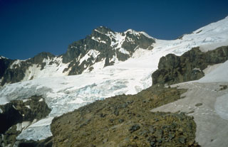 Colfax Peak (center) is an erosional remnant of Black Buttes volcano, a predecessor to Mount Baker that was active from about 500,000 to 300,000 years ago. Coleman Saddle (right center) divides the NE-dipping lavas of Black Buttes from Mount Baker, whose summit lies out of view to the upper right. Easton Glacier descends diagonally across the photo to the SW.
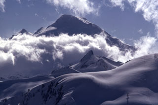 The historically active crater of Mount Baker, seen here from the NE rim of the Pleistocene Kulshan Caldera, lies between the summit and Sherman Peak (left horizon). The snow-mantled slopes in the foreground are located within Kulshan Caldera, which remained undiscovered until the 1990s because associated pyroclastic flow and ashfall deposits outside the caldera had been removed by Pleistocene glaciers. Coleman Pinnacle (center) is a remnant of a post-caldera fissure-fed lava flow.
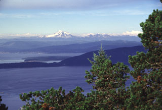 Mount Baker forms a prominent landmark visible throughout much of the northern Puget Sound region. Its glaciated slopes rise above Bellingham Bay, as seen here from Mount Constitution on Orcas Island. Lummi Island, another of the San Juan Islands, forms the ridge extending across the center of the photo. The Twin Sisters massif, composed of olivine-rich ultramafic rocks derived from the Earth's mantle, is located immediately SW (right) of Mount Baker.
The following 2 samples associated with this volcano can be found in the Smithsonian's NMNH Department of Mineral Sciences collections, and may be availble for research (contact the Rock and Ore Collections Manager). Catalog number links will open a window with more information.
| Catalog Number | Sample Description | Lava Source | Collection Date |
|---|---|---|---|
| NMNH 116134-1 | Andesite | -- | -- |
| NMNH 116134-2 | Andesite | -- | -- |
| Copernicus Browser | The Copernicus Browser replaced the Sentinel Hub Playground browser in 2023, to provide access to Earth observation archives from the Copernicus Data Space Ecosystem, the main distribution platform for data from the EU Copernicus missions. |
| MIROVA | Middle InfraRed Observation of Volcanic Activity (MIROVA) is a near real time volcanic hot-spot detection system based on the analysis of MODIS (Moderate Resolution Imaging Spectroradiometer) data. In particular, MIROVA uses the Middle InfraRed Radiation (MIR), measured over target volcanoes, in order to detect, locate and measure the heat radiation sourced from volcanic activity. |
| MODVOLC Thermal Alerts | Using infrared satellite Moderate Resolution Imaging Spectroradiometer (MODIS) data, scientists at the Hawai'i Institute of Geophysics and Planetology, University of Hawai'i, developed an automated system called MODVOLC to map thermal hot-spots in near real time. For each MODIS image, the algorithm automatically scans each 1 km pixel within it to check for high-temperature hot-spots. When one is found the date, time, location, and intensity are recorded. MODIS looks at every square km of the Earth every 48 hours, once during the day and once during the night, and the presence of two MODIS sensors in space allows at least four hot-spot observations every two days. Each day updated global maps are compiled to display the locations of all hot spots detected in the previous 24 hours. There is a drop-down list with volcano names which allow users to 'zoom-in' and examine the distribution of hot-spots at a variety of spatial scales. |
|
WOVOdat
Single Volcano View Temporal Evolution of Unrest Side by Side Volcanoes |
WOVOdat is a database of volcanic unrest; instrumentally and visually recorded changes in seismicity, ground deformation, gas emission, and other parameters from their normal baselines. It is sponsored by the World Organization of Volcano Observatories (WOVO) and presently hosted at the Earth Observatory of Singapore.
GVMID Data on Volcano Monitoring Infrastructure The Global Volcano Monitoring Infrastructure Database GVMID, is aimed at documenting and improving capabilities of volcano monitoring from the ground and space. GVMID should provide a snapshot and baseline view of the techniques and instrumentation that are in place at various volcanoes, which can be use by volcano observatories as reference to setup new monitoring system or improving networks at a specific volcano. These data will allow identification of what monitoring gaps exist, which can be then targeted by remote sensing infrastructure and future instrument deployments. |
| Volcanic Hazard Maps | The IAVCEI Commission on Volcanic Hazards and Risk has a Volcanic Hazard Maps database designed to serve as a resource for hazard mappers (or other interested parties) to explore how common issues in hazard map development have been addressed at different volcanoes, in different countries, for different hazards, and for different intended audiences. In addition to the comprehensive, searchable Volcanic Hazard Maps Database, this website contains information about diversity of volcanic hazard maps, illustrated using examples from the database. This site is for educational purposes related to volcanic hazard maps. Hazard maps found on this website should not be used for emergency purposes. For the most recent, official hazard map for a particular volcano, please seek out the proper institutional authorities on the matter. |
| IRIS seismic stations/networks | Incorporated Research Institutions for Seismology (IRIS) Data Services map showing the location of seismic stations from all available networks (permanent or temporary) within a radius of 0.18° (about 20 km at mid-latitudes) from the given location of Baker. Users can customize a variety of filters and options in the left panel. Note that if there are no stations are known the map will default to show the entire world with a "No data matched request" error notice. |
| UNAVCO GPS/GNSS stations | Geodetic Data Services map from UNAVCO showing the location of GPS/GNSS stations from all available networks (permanent or temporary) within a radius of 20 km from the given location of Baker. Users can customize the data search based on station or network names, location, and time window. Requires Adobe Flash Player. |
| DECADE Data | The DECADE portal, still in the developmental stage, serves as an example of the proposed interoperability between The Smithsonian Institution's Global Volcanism Program, the Mapping Gas Emissions (MaGa) Database, and the EarthChem Geochemical Portal. The Deep Earth Carbon Degassing (DECADE) initiative seeks to use new and established technologies to determine accurate global fluxes of volcanic CO2 to the atmosphere, but installing CO2 monitoring networks on 20 of the world's 150 most actively degassing volcanoes. The group uses related laboratory-based studies (direct gas sampling and analysis, melt inclusions) to provide new data for direct degassing of deep earth carbon to the atmosphere. |
| Large Eruptions of Baker | Information about large Quaternary eruptions (VEI >= 4) is cataloged in the Large Magnitude Explosive Volcanic Eruptions (LaMEVE) database of the Volcano Global Risk Identification and Analysis Project (VOGRIPA). |
| EarthChem | EarthChem develops and maintains databases, software, and services that support the preservation, discovery, access and analysis of geochemical data, and facilitate their integration with the broad array of other available earth science parameters. EarthChem is operated by a joint team of disciplinary scientists, data scientists, data managers and information technology developers who are part of the NSF-funded data facility Integrated Earth Data Applications (IEDA). IEDA is a collaborative effort of EarthChem and the Marine Geoscience Data System (MGDS). |

