
CVO reported that the strongest earthquake in the Mount Hood area in decades occurred on 29 June at 0736. The widely felt M 4.5 event was located ~4.5 km S of the summit at a depth of 6 km. Hundreds of aftershocks followed, including two greater than M 3. Typically, several earthquake swarms occur each year at Mount Hood.
Sources: Associated Press, US Geological Survey Cascades Volcano Observatory (CVO)
Strongest earthquake in decades registered on 29 June 2002 (M 4.5); aftershocks
The strongest earthquake in the Mount Hood area in decades occurred on 29 June 2002 at 0736, according to the USGS Cascades Volcano Observatory (CVO). The widely felt M 4.5 event was located ~4.5 km S of the summit (figure 3) at a depth of 6 km. Hundreds of aftershocks followed, including two greater than M 3. Typically, several earthquake swarms occur each year at Mount Hood.
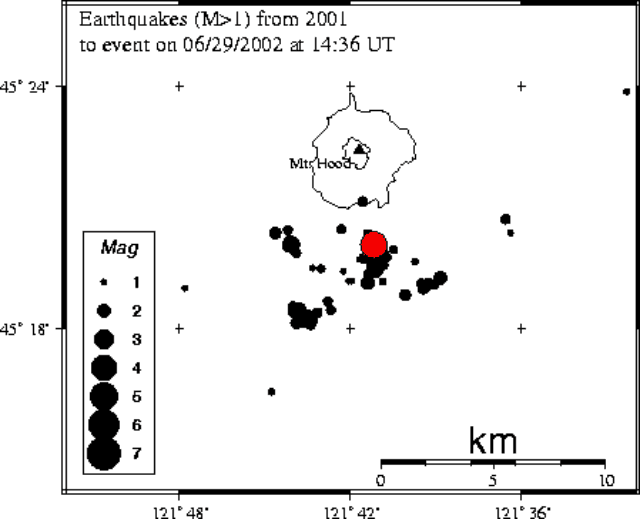 |
Figure 3. A map of all earthquakes (M 1.0) that occurred at Hood from the start of 2001 to 29 June 2002. The area shown details a few kilometers around the M 4.5 event on 29 June 2002. Courtesy PNSN. |
Information Contacts: Cascades Volcano Observatory (CVO), United States Geological Survey (USGS), 5400 MacArthur Blvd., Vancouver, WA 98661, USA (URL: https://volcanoes.usgs.gov/observatories/cvo/); Pacific Northwest Seismograph Network (PNSN), University of Washington, Department of Earth and Space Sciences, Box 351310, Seattle, WA 98195-1310, USA (URL: http://www.ess.washington.edu/SEIS/PNSN/).
2002: June
2001: January
| September
CVO reported that the strongest earthquake in the Mount Hood area in decades occurred on 29 June at 0736. The widely felt M 4.5 event was located ~4.5 km S of the summit at a depth of 6 km. Hundreds of aftershocks followed, including two greater than M 3. Typically, several earthquake swarms occur each year at Mount Hood.
Sources: Associated Press; US Geological Survey Cascades Volcano Observatory (CVO)
The USGS Cascades Volcano Observatory reported that a minor earthquake swarm occurred at Mount Hood from 9 September until at least 14 September. About 25 events were detected, with a maximum magnitude of 2.9. The epicenters of the earthquakes were ~8 km SSW of the volcano's summit at depths of 1-7 km. These types of swarms occur once or twice per year at Mount Hood.
Source: US Geological Survey Cascades Volcano Observatory (CVO)
The Cascades Volcano Observatory (CVO) reported that during 10-20 January a swarm of 13 earthquakes with magnitudes ranging from 0.2-2.0 occurred in an area about 4-8 km SSE of the summit at a depth of 4-7 km. This activity is not abnormal; Mount Hood averages one to two small swarms a year, with the last swarm occurring in May 2000. The current swarm consisted of fewer and smaller events than is typical, but it may not have yet ended.
Sources: Associated Press; US Geological Survey Cascades Volcano Observatory (CVO)
Reports are organized chronologically and indexed below by Month/Year (Publication Volume:Number), and include a one-line summary. Click on the index link or scroll down to read the reports.
Earthquake swarm
[Seismic data in the following report have been extensively modified using Rite and Iyer (1981).] A series of earthquakes in the vicinity of Mt. Hood, about 100 km SSE of Mt. St. Helens, began with a M [2.8] shock on 6 July at 1817. [Within 30 minutes, 7 events of M 1.6-2.8 occurred in the vicinity of the first shock. Depths were tightly clustered at 4-7 km.]
[Activity remained anomalously high for about 48 hours after the initial shock, with 40 events recorded on 3-9 stations in the first 24 hours (figure 1). Epicenters were generally on the S flank (figure 2).] A M [2.44] earthquake at 0259 and a M [2.25] event at 1315 were centered [near the summit] at [5.9 and 5.3] km depth. [Between 6-16 July, 143 small events were recorded on a single station (VHE) about 5 km SE of the summit. About 50 were correlated with nearby stump blasting, but the other 90 appeared to be swarm events, most with coda magnitudes less than 0.5.]... The swarm's total seismic energy release [was about 8 x 10¹⁵ ergs]....
 |
Figure 1. Histogram of seismic activity at Mt. Hood, 6-20 July 1980, after Rite and Iyer (1981). |
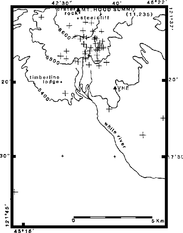 |
Figure 2. Epicenters of most of the July 1980 events at Mt. Hood. Sizes of crosses are proportional to event magnitudes. After Rite and Iyer (1981). |
The USGS issued a hazard watch formally notifying government officials. On 11 July, the USGS and the University of Washington installed three portable seismographs on Mt. Hood. No harmonic tremor has been recorded, and no new surface activity has been observed. Gas analyses made from aircraft on 11 July showed no increase in atmospheric SO2 or CO2 above normal levels.
Because no additional seismicity and no new eruptive activity have occurred at Mt. Hood, the USGS ended the hazard watch on 5 August.
References. Rite, A., and Iyer, H.M., 1981, July 1980 Mt. Hood earthquake swarm: USGS Open File Report 81-48, 22 p.
Information Contacts: R. Decker, R. Tilling, and C. Zablocki, USGS; S. Malone, R. Crosson, and E. Endo, Univ. of Washington.
Mid-January swarms of tectonic earthquakes
An earthquake swarm occurred near Mount Hood in northern Oregon beginning on 11 January. More than two dozen earthquakes were produced that day, the largest of which were M 3.2 (at 1404) and M 3.0 (at 0854). Following a pause during 12-13 January, a M 3.2 earthquake at 0356 and a M 3.0 earthquake at 0813 occurred on 14 January. The largest earthquakes were felt at Timberline, Brightwood, Parkdale, and Mount Hood Meadows. By noon on 14 January the Cascades Volcano Observatory had detected 66 earthquakes, 33 of them large enough to be well-located.
All of the earthquakes in the recent swarms had characteristics similar to tectonic earthquakes rather than volcanic earthquakes (indicative of magma movement). They most likely resulted from regional tectonic stresses, although they may have also been caused by deep-seated changes in the volcano's plumbing system. Additional and significantly different geological and geophysical indicators would be expected before any future eruptive activity. Scientists will continue to monitor the situation closely. They may add additional instrumentation to the monitoring network to learn more about earthquakes in this region.
Since 1990 Hood has produced about fifteen earthquake swarms similar to the recent one. These swarms have lasted from a few hours to several days and have generally produced maximum magnitudes between 1.6 and 3.5. Many earthquakes have been well-located, and are generally clustered 4-7 km S of the volcano's summit. Seismic data of lower quality suggest that swarms also occurred in the 1970s and 1980s. The largest recorded earthquake at Mount Hood was a M 4.0 in December 1974.
Information Contacts: Cascades Volcano Observatory, U.S. Geological Survey, 5400 MacArthur Blvd., Vancouver, WA 98661 USA (URL: https://volcanoes.usgs.gov/observatories/cvo/); Geophysics Program, University of Washington, Seattle, WA 98195 USA (URL: http://www.geophys.washington.edu/).
Late-1999 mass wasting; January 2001 earthquake swarm
After the earthquake swarms in January 1999 (BGVN 24:01), two reports of anomalous activity at Hood were received; in September and October of 2000 landslides and debris flows traveled down the flanks of the volcano, and in January 2001 small earthquake swarms occurred.
The Cascades Volcano Observatory (CVO) reported that intense rainfall during 30 September to 1 October 2000 triggered a series of landslides and debris flows in several of Hood's drainages. The largest flows occurred in White River Valley on the S flank and Newton Creek Valley on the E flank. Both streams were diverted from their channels and severely damaged two sections of Oregon Highway 35; one section is an important link between I-84 and US 26, and the other is a recreational highway that provides access to Mount Hood Meadows Ski Area. The landslides and debris flows caused more than $1 million in damage. The Oregon Department of Transportation reopened the highway on 27 October.
According to CVO, a small earthquake swarm occurred at Hood during 10-19 January 2001. During this period a swarm of 13 earthquakes, with magnitudes ranging from 0.2-2.0, occurred in an area ~4-8 km SSE of the summit at a depth of 4-7 km. This area is frequently a source of earthquake swarms, but this swarm consisted of fewer and smaller events than is typical. The last similar type of swarm occurred in May 2000. On average, 1-2 swarms of small earthquakes occur at Hood each year.
Information Contacts: Cascades Volcano Observatory, U.S. Geological Survey, 5400 MacArthur Blvd., Vancouver, WA 98661 USA (URL: https://volcanoes.usgs.gov/observatories/cvo/).
Strongest earthquake in decades registered on 29 June 2002 (M 4.5); aftershocks
The strongest earthquake in the Mount Hood area in decades occurred on 29 June 2002 at 0736, according to the USGS Cascades Volcano Observatory (CVO). The widely felt M 4.5 event was located ~4.5 km S of the summit (figure 3) at a depth of 6 km. Hundreds of aftershocks followed, including two greater than M 3. Typically, several earthquake swarms occur each year at Mount Hood.
|
Figure 3. A map of all earthquakes (M 1.0) that occurred at Hood from the start of 2001 to 29 June 2002. The area shown details a few kilometers around the M 4.5 event on 29 June 2002. Courtesy PNSN. |
Information Contacts: Cascades Volcano Observatory (CVO), United States Geological Survey (USGS), 5400 MacArthur Blvd., Vancouver, WA 98661, USA (URL: https://volcanoes.usgs.gov/observatories/cvo/); Pacific Northwest Seismograph Network (PNSN), University of Washington, Department of Earth and Space Sciences, Box 351310, Seattle, WA 98195-1310, USA (URL: http://www.ess.washington.edu/SEIS/PNSN/).
This compilation of synonyms and subsidiary features may not be comprehensive. Features are organized into four major categories: Cones, Craters, Domes, and Thermal Features. Synonyms of features appear indented below the primary name. In some cases additional feature type, elevation, or location details are provided.
Synonyms |
||||
| Wyeast | ||||
Cones |
||||
| Feature Name | Feature Type | Elevation | Latitude | Longitude |
| Pinnacle, the | Vent | 1593 m | 45° 26' 0" N | 121° 42' 0" W |
Domes |
||||
| Feature Name | Feature Type | Elevation | Latitude | Longitude |
| Crater Rock | Dome | 3219 m | 45° 22' 0" N | 121° 42' 0" W |
|
|
||||||||||||||||||||||||||
There is data available for 5 confirmed Holocene eruptive periods.
[ 1907 Aug 28 ] Discredited Eruption
In August 1907 a topographer for the US Geological Survey camped below the volcano noticed smoke or steam rising from near Crater Rock and glow at night. White River water volume greatly increased the following day (Harris, 1988). This is considered to be an observation of non-eruptive fumarolic activity.
[ 1869 ] Uncertain Eruption
| Episode 1 | Eruption Episode | |||||
|---|---|---|---|---|---|
| 1869 - Unknown | Evidence from Unknown | ||||
| Plummer cited an eruption in 1869; no details (Harris, 1988). | |||||
1865 Sep 21 - 1866 Jan (?) Confirmed Eruption Max VEI: 2
| Episode 1 | Eruption Episode | ||||||||||||||||||||||||||||||||||||||||
|---|---|---|---|---|---|---|---|---|---|---|---|---|---|---|---|---|---|---|---|---|---|---|---|---|---|---|---|---|---|---|---|---|---|---|---|---|---|---|---|---|
| 1865 Sep 21 - 1866 Jan (?) | Evidence from Observations: Reported | |||||||||||||||||||||||||||||||||||||||
| Dense "black smoke" and "flames" were reported on 21 September 1865. The historian Bancroft reported that Hood was in eruption until 8 October 1865 (Harris, 1976). An unpublished letter indicates that Hood continued "smoking" until at least January 1866 (Harris, 1988). | ||||||||||||||||||||||||||||||||||||||||
|
List of 6 Events for Episode 1
| ||||||||||||||||||||||||||||||||||||||||
1859 Aug 15 - 1859 Aug 17 Confirmed Eruption Max VEI: 2
| Episode 1 | Eruption Episode | ||||||||||||||||||||||||||||||
|---|---|---|---|---|---|---|---|---|---|---|---|---|---|---|---|---|---|---|---|---|---|---|---|---|---|---|---|---|---|---|
| 1859 Aug 15 - 1859 Aug 17 | Evidence from Observations: Reported | |||||||||||||||||||||||||||||
| Newspaper accounts on 20 August 1859 reported that Mount Hood had been in eruption. "Flames" were observed and ash appeared to cover the slopes. Perrey lists a 15-17 August date for the eruption. An eyewitness account (written in 1902) gives a September date, which may refer to the same August eruption (Harris, 1988). | ||||||||||||||||||||||||||||||
|
List of 4 Events for Episode 1
| ||||||||||||||||||||||||||||||
[ 1854 Aug ] Uncertain Eruption
| Episode 1 | Eruption Episode | |||||
|---|---|---|---|---|---|
| 1854 Aug - Unknown | Evidence from Unknown | ||||
| Reported active by Perrey in August 1854; no additional details (Harris, 1988). | |||||
[ 1853 ] Uncertain Eruption
| Episode 1 | Eruption Episode | |||||||||||||||
|---|---|---|---|---|---|---|---|---|---|---|---|---|---|---|---|
| 1853 - Unknown | Evidence from Unknown | ||||||||||||||
| Perrey reports that Mount Hood was active in 1853; no additional details (Harris, 1988). | |||||||||||||||
|
List of 1 Events for Episode 1
| |||||||||||||||
1781 Oct 15 ± 45 days - 1801 (?) Confirmed Eruption
| Episode 1 | Eruption Episode | Crater Rock | |||||||||||||||||||||||||||||
|---|---|---|---|---|---|---|---|---|---|---|---|---|---|---|---|---|---|---|---|---|---|---|---|---|---|---|---|---|---|---|
| 1781 Oct 15 ± 45 days - 1801 (?) | Evidence from Sidereal: Dendrochronology | |||||||||||||||||||||||||||||
| Tree-ring dating of trees damaged by lahars indicate that the onset of the Old Maid eruptive period took place in autumn of 1781, as seen from thin late wood growth in the 1781 tree ring (Pringle et al., 2010; Pierson et al., 2011). The main period of magmatic activity continued until 1793, and eruptive activity may have continued until 1800 or possibly 1801, within five years of the Lewis and Clark visits (Pringle et al., 2010). Runout from the lahar produced a delta and shallow river bed where the Sandy reached the Columbia River that was noted by Captain Clark in 1805 and 1806. Tephra layers occur in sediments of an ephemeral lake formed when the lahar blocked the Muddy Fork drainage. Crandell (1980) noted evidence of hot, prismatically jointed dacitic rock fragments in early Old Maid stage Sandy River lahars and associated this and later lahars with the growth of Crater Rock lava dome. A lithic-rich pyroclastic flow also traveled down the White River drainage to the east, and the pyroclastic flow deposit is overlain by at least two lahars and thin tephra layers. | ||||||||||||||||||||||||||||||
|
List of 4 Events for Episode 1 at Crater Rock
| ||||||||||||||||||||||||||||||
0480 ± 37 years Confirmed Eruption
| Episode 1 | Eruption Episode | Crater Rock | |||||||||||||||||||||||||||||||||||||||
|---|---|---|---|---|---|---|---|---|---|---|---|---|---|---|---|---|---|---|---|---|---|---|---|---|---|---|---|---|---|---|---|---|---|---|---|---|---|---|---|---|
| 0480 ± 37 years - Unknown | Evidence from Isotopic: 14C (calibrated) | |||||||||||||||||||||||||||||||||||||||
| The Timberline eruptive period began following about 10,000 years of dormancy. A debris avalanche early in the eruptive period left a SSW-facing open scarp inside which a lava dome was constructed. Lahars associated with the debris avalanche traveled down the Sandy River as far as the Columbia River. Pyroclastic flows and lahars accompanied lava dome formation at Crater Rock, forming the broad SW flank debris fan. A large number of radiocarbon dates spanning a range of several centuries have been obtained for this eruptive period, and Scott (2014, written comm.) assigned a calibrated age of about 1,450-1,500 BP. A dormant period of at least several decades occurred during the Timberline eruptive period. Lahars and a tephra layer dated at about 560 ± 150 years BP attributed to a later Zigzag eruptive period (Cameron and Pringle, 1986) are considered to be non-eruptive events (Scott, 2014 written comm.). | ||||||||||||||||||||||||||||||||||||||||
|
List of 6 Events for Episode 1 at Crater Rock
| ||||||||||||||||||||||||||||||||||||||||
4940 BCE ± 150 years Confirmed Eruption Max VEI: 2
| Episode 1 | Eruption Episode | Lower NE flank (SSW of Parkdale) | ||||||||||||||||||||||||||||||||||
|---|---|---|---|---|---|---|---|---|---|---|---|---|---|---|---|---|---|---|---|---|---|---|---|---|---|---|---|---|---|---|---|---|---|---|---|
| 4940 BCE ± 150 years - Unknown | Evidence from Isotopic: 14C (uncalibrated) | ||||||||||||||||||||||||||||||||||
| A lava flow, perhaps unrelated to Hood, traveled about 6 km N from a cinder cone along the Middle Fork Hood River immediately beyond the NE flank of Hood and is 14C dated 6,890 ± 130 BP (Crandell, 1980; Sherrod in Wood and Kienle, 1990). | |||||||||||||||||||||||||||||||||||
|
List of 5 Events for Episode 1 at Lower NE flank (SSW of Parkdale)
| |||||||||||||||||||||||||||||||||||
There is no Deformation History data available for Hood.
There is no Emissions History data available for Hood.
 Mount Hood, seen here from the north across the Columbia River Gorge, rises above low hills of older volcanic rocks. Located only 75 km ENE of Portland, Mount Hood is near communities, infrastructure, and transportation routes, posing risk from eruptive activity and debris flows. The morphology of the summit area has been modified by flank collapse events that formed debris avalanches.
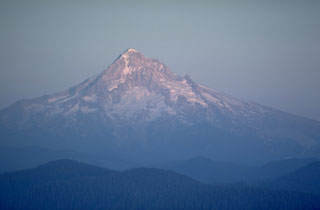 Mount Hood, seen here from Larch Mountain on the NW side, is a recently active volcano in Oregon. A major eruptive period occurred in the late 1700s, and 19th-century Pacific Northwest tribes and settlers observed minor eruptions.
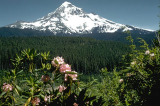 Mount Hood, one of Oregon's highest peaks, rises above the Lolo Pass area on its NW side. Hood is a prominent landmark on both sides of the Columbia River. The summit of the glacially eroded volcano contains several lava domes. At least four major eruptive periods have occurred during the past 15,000 years, including in the late 1700s. Minor 19th century eruptions were witnessed from the city of Portland.
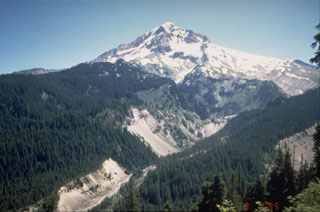 The upper Sandy River valley on the SW side of Mount Hood has been one of the primary channels for lahars and block-and-ash flows during the past 1,800 years. These late-stage eruptions originated from vents and lava domes high on the SW flank.
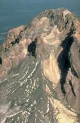 This aerial view of Mount Hood from the south shows the Crater Rock lava dome remnants in the center of the photo. The 400-m-wide, 170-m-high Crater Rock dome erupted around 1780 CE and produced block-and-ash flows and resulted in lahars during episodic dome growth. Deposits are distributed along the Sandy River and White River drainages.
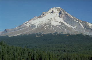 Trillium Lake provides a dramatic view of the broad debris fan on the S flank of Mount Hood that originated from growth of the Crater Rock lava dome, visible on the upper SW flank just below the summit. Dome growth and collapse produced block-and-ash flows and resulted in lahars down the Sandy River and White River drainages.
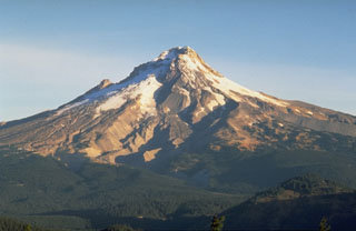 Mount Hood is seen here from Frog Butte on the SE side and shows the canyons of the White River drainage in the center. The smooth debris fan to its left formed during of growth and collapse of the Crater Rock lava dome just south of the summit. Illumination Rock forms the small peak midway up the left skyline.
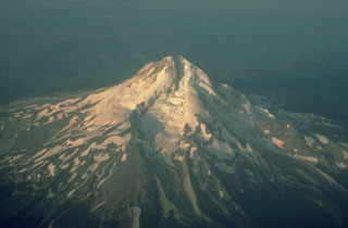 This aerial view from the NE shows Eliot Glacier descending the valley in the center, with glacial moraines at its base. During the late Pleistocene a major lahar from Mount Hood swept to the north across the Columbia River, temporarily filling it to a depth of 30 m.
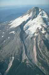 The north flank of Mount Hood contains the Eliot Glacier, with a series of prominent glacial moraines at its base in this 1987 photo. During the past 1,800 years eruptions have been restricted to vents on the SW flank and have included dome growth, collapse, and debris flows.
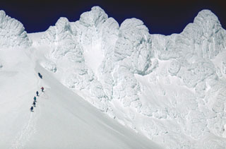 Oregon's Mount Hood is one of the most frequently climbed volcanoes in the Cascade Range. A group of climbers above the base of Crater Rock lava dome on the upper SW flank approaches Steel Cliffs that form the summit ridge.
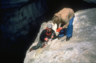 Scientists from the U.S. Geological Survey take gas samples at Devils Kitchen near the Crater Rock lava dome on the upper SW flank of Mount Hood. The Crater Rock area produces vigorous gas emission and results in extensive hydrothermal alteration of rock masses over broad areas.
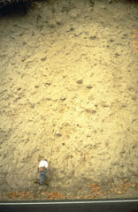 A thick lahar deposit resulted from a 100,000-year-old debris avalanche produced by a collapse of the N side of Mount Hood. It swept down the Hood River valley and traveled across the Columbia River, temporarily damming it to a depth of 30 m. This thick outcrop that contains rounded boulders in a clay-rich matrix, is located N of Underwood, Washington, on the other side of the Columbia River.
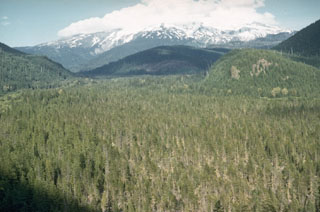 The flat-bottomed, forested floor of the upper Sandy River is underlain by debris flow deposits associated with growth of the Crater Rock lava dome on the upper SW flank of Mount Hood. Tree-ring dating places the age of these deposits during the mid-1780's. The lahars traveled as far as the Columbia River and the shallow, sediment-choked lower Sandy River was observed shortly after emplacement of the lahars by the Lewis and Clark expedition.
 The blocky Parkdale lava flow, which traveled 6 km from a scoria cone located along the Middle Fork Hood River near the N flank of Mount Hood, towers above houses in the agricultural Hood River valley. The Parkdale flow has been radiocarbon dated at about 6,890 years.
The maps shown below have been scanned from the GVP map archives and include the volcano on this page. Clicking on the small images will load the full 300 dpi map. Very small-scale maps (such as world maps) are not included. The maps database originated over 30 years ago, but was only recently updated and connected to our main database. We welcome users to tell us if they see incorrect information or other problems with the maps; please use the Contact GVP link at the bottom of the page to send us email.
The following 2 samples associated with this volcano can be found in the Smithsonian's NMNH Department of Mineral Sciences collections, and may be availble for research (contact the Rock and Ore Collections Manager). Catalog number links will open a window with more information.
| Catalog Number | Sample Description | Lava Source | Collection Date |
|---|---|---|---|
| NMNH 113090-1 | Andesite | -- | 1 Aug 1969 |
| NMNH 113090-2 | Andesite | -- | 1 Aug 1969 |
| Copernicus Browser | The Copernicus Browser replaced the Sentinel Hub Playground browser in 2023, to provide access to Earth observation archives from the Copernicus Data Space Ecosystem, the main distribution platform for data from the EU Copernicus missions. |
| MIROVA | Middle InfraRed Observation of Volcanic Activity (MIROVA) is a near real time volcanic hot-spot detection system based on the analysis of MODIS (Moderate Resolution Imaging Spectroradiometer) data. In particular, MIROVA uses the Middle InfraRed Radiation (MIR), measured over target volcanoes, in order to detect, locate and measure the heat radiation sourced from volcanic activity. |
| MODVOLC Thermal Alerts | Using infrared satellite Moderate Resolution Imaging Spectroradiometer (MODIS) data, scientists at the Hawai'i Institute of Geophysics and Planetology, University of Hawai'i, developed an automated system called MODVOLC to map thermal hot-spots in near real time. For each MODIS image, the algorithm automatically scans each 1 km pixel within it to check for high-temperature hot-spots. When one is found the date, time, location, and intensity are recorded. MODIS looks at every square km of the Earth every 48 hours, once during the day and once during the night, and the presence of two MODIS sensors in space allows at least four hot-spot observations every two days. Each day updated global maps are compiled to display the locations of all hot spots detected in the previous 24 hours. There is a drop-down list with volcano names which allow users to 'zoom-in' and examine the distribution of hot-spots at a variety of spatial scales. |
|
WOVOdat
Single Volcano View Temporal Evolution of Unrest Side by Side Volcanoes |
WOVOdat is a database of volcanic unrest; instrumentally and visually recorded changes in seismicity, ground deformation, gas emission, and other parameters from their normal baselines. It is sponsored by the World Organization of Volcano Observatories (WOVO) and presently hosted at the Earth Observatory of Singapore.
GVMID Data on Volcano Monitoring Infrastructure The Global Volcano Monitoring Infrastructure Database GVMID, is aimed at documenting and improving capabilities of volcano monitoring from the ground and space. GVMID should provide a snapshot and baseline view of the techniques and instrumentation that are in place at various volcanoes, which can be use by volcano observatories as reference to setup new monitoring system or improving networks at a specific volcano. These data will allow identification of what monitoring gaps exist, which can be then targeted by remote sensing infrastructure and future instrument deployments. |
| Volcanic Hazard Maps | The IAVCEI Commission on Volcanic Hazards and Risk has a Volcanic Hazard Maps database designed to serve as a resource for hazard mappers (or other interested parties) to explore how common issues in hazard map development have been addressed at different volcanoes, in different countries, for different hazards, and for different intended audiences. In addition to the comprehensive, searchable Volcanic Hazard Maps Database, this website contains information about diversity of volcanic hazard maps, illustrated using examples from the database. This site is for educational purposes related to volcanic hazard maps. Hazard maps found on this website should not be used for emergency purposes. For the most recent, official hazard map for a particular volcano, please seek out the proper institutional authorities on the matter. |
| IRIS seismic stations/networks | Incorporated Research Institutions for Seismology (IRIS) Data Services map showing the location of seismic stations from all available networks (permanent or temporary) within a radius of 0.18° (about 20 km at mid-latitudes) from the given location of Hood. Users can customize a variety of filters and options in the left panel. Note that if there are no stations are known the map will default to show the entire world with a "No data matched request" error notice. |
| UNAVCO GPS/GNSS stations | Geodetic Data Services map from UNAVCO showing the location of GPS/GNSS stations from all available networks (permanent or temporary) within a radius of 20 km from the given location of Hood. Users can customize the data search based on station or network names, location, and time window. Requires Adobe Flash Player. |
| DECADE Data | The DECADE portal, still in the developmental stage, serves as an example of the proposed interoperability between The Smithsonian Institution's Global Volcanism Program, the Mapping Gas Emissions (MaGa) Database, and the EarthChem Geochemical Portal. The Deep Earth Carbon Degassing (DECADE) initiative seeks to use new and established technologies to determine accurate global fluxes of volcanic CO2 to the atmosphere, but installing CO2 monitoring networks on 20 of the world's 150 most actively degassing volcanoes. The group uses related laboratory-based studies (direct gas sampling and analysis, melt inclusions) to provide new data for direct degassing of deep earth carbon to the atmosphere. |
| Large Eruptions of Hood | Information about large Quaternary eruptions (VEI >= 4) is cataloged in the Large Magnitude Explosive Volcanic Eruptions (LaMEVE) database of the Volcano Global Risk Identification and Analysis Project (VOGRIPA). |
| EarthChem | EarthChem develops and maintains databases, software, and services that support the preservation, discovery, access and analysis of geochemical data, and facilitate their integration with the broad array of other available earth science parameters. EarthChem is operated by a joint team of disciplinary scientists, data scientists, data managers and information technology developers who are part of the NSF-funded data facility Integrated Earth Data Applications (IEDA). IEDA is a collaborative effort of EarthChem and the Marine Geoscience Data System (MGDS). |

