The Global Volcanism Program has no activity reports available for Lavic Lake.
The Global Volcanism Program has no Weekly Reports available for Lavic Lake.
The Global Volcanism Program has no Bulletin Reports available for Lavic Lake.
|
|
||||||||||||||||||||||||||
The Global Volcanism Program is not aware of any Holocene eruptions from Lavic Lake. If this volcano has had large eruptions (VEI >= 4) prior to 12,000 years ago, information might be found on the Lavic Lake page in the LaMEVE (Large Magnitude Explosive Volcanic Eruptions) database, a part of the Volcano Global Risk Identification and Analysis Project (VOGRIPA).
This compilation of synonyms and subsidiary features may not be comprehensive. Features are organized into four major categories: Cones, Craters, Domes, and Thermal Features. Synonyms of features appear indented below the primary name. In some cases additional feature type, elevation, or location details are provided.
Cones |
||||
| Feature Name | Feature Type | Elevation | Latitude | Longitude |
| Pisgah Crater | Pyroclastic cone | 775 m | 34° 45' 0.00" N | 116° 22' 30.00" W |
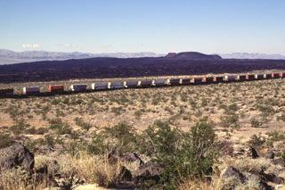 A freight train passes Pisgah Crater and its associated lava field. The 100-m-high cone is the most prominent feature of a lava field that covers 100 km2. The irregular shape of the cone results from the mining of aggregate. The composite lava flows extend up to 8 km to the SE and in a narrow lobe 18 km to the NW. Most of the flows are pahoehoe, but some of the eastern flows are aa. Other cones and lava flows of the Lavic Lake volcanic field are located nearby.
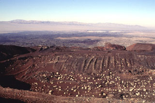 The cone of Pisgah Crater has been modified by mining operations that provide a source of road aggregate. The cone is the most prominent feature of the Lavic Lake volcanic field in southern California. A broad lava field erupted from nearby vents surrounds the cone; a narrow lobe that extends up to 18 km to the NW can be seen in this view.
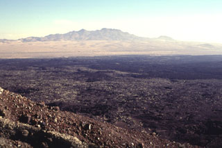 The NE rim of Pisgah Crater provides a view of the 100-sq-km lava field surrounding the crater. The basaltic lava field was erupted from the crater and nearby vents and is dominantly formed of pahoehoe lava, although aa lavas were erupted on the eastern side. Interstate highway 40 skirts the northern margins of the lava flow, below the Cady Mountains in the distance. The lavas were erupted onto alluvial-fan and playa-lake deposits.
  Pisgah Crater is the most prominent feature of the Lavic Lake volcanic field, which contains four Quaternary cinder cones. The 100-m-high Pisgah Crater, seen here from the NW, and its surrounding 100-sq-km lava field are easily seen from nearby Interstate highway 40. The crater and nearby vents were the source of dominantly pahoehoe lava flows that traveled as far as 18 km NW over alluvial-fan and playa-lake deposits. Pisgah Crater was initially considered to be Holocene in age, but more recent dating indicates it is about 25,000 years old.
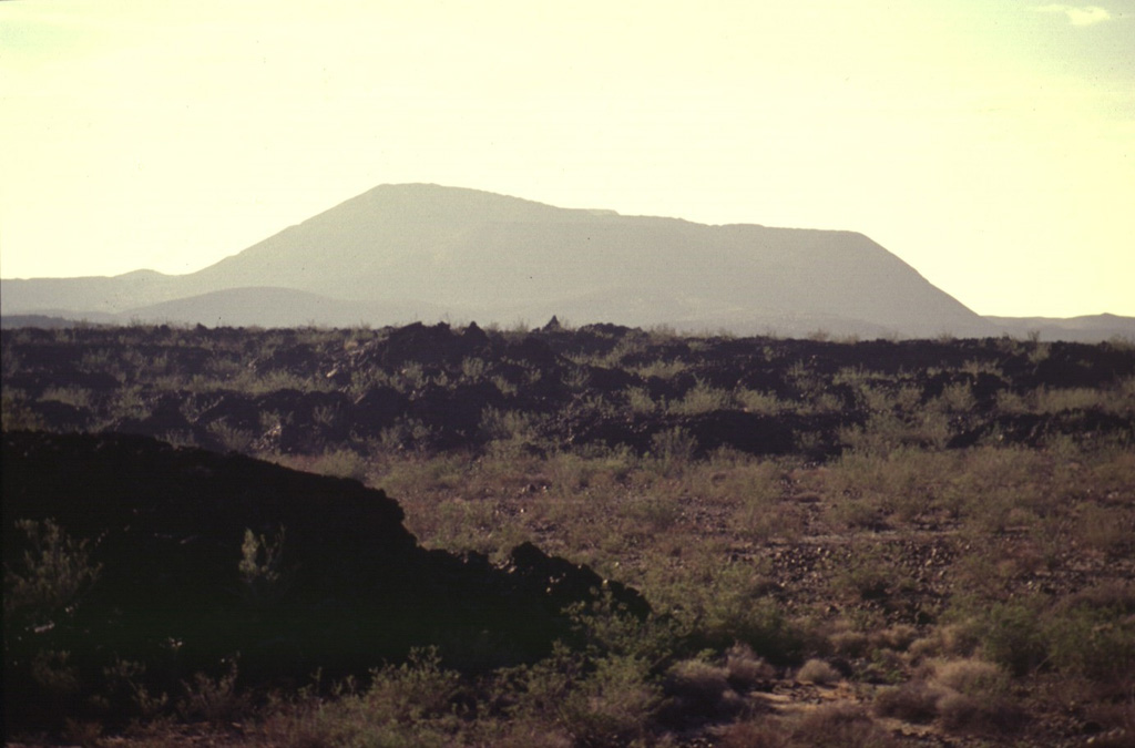
 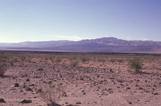 The dark-colored area seen in the distance across the dry Lavic Lake is a cinder cone and associated lava field that is one of the young vents of the Lavic Lake volcanic field. The youthful-looking lava flows originated from the Sunshine Peak area of the Lava Beds Mountains, south of the better known Pisgah Crater.
The following 18 samples associated with this volcano can be found in the Smithsonian's NMNH Department of Mineral Sciences collections, and may be availble for research (contact the Rock and Ore Collections Manager). Catalog number links will open a window with more information.
| Catalog Number | Sample Description | Lava Source | Collection Date |
|---|---|---|---|
| NMNH 115038-1 | Basalt | PISGAH CRATER | -- |
| NMNH 115038-10 | Basalt | PISGAH CRATER | -- |
| NMNH 115038-2 | Basalt | PISGAH CRATER | -- |
| NMNH 115038-3 | Basalt | PISGAH CRATER | -- |
| NMNH 115038-4 | Basalt | PISGAH CRATER | -- |
| NMNH 115038-5 | Basalt | PISGAH CRATER | -- |
| NMNH 115038-6 | Basalt | PISGAH CRATER | -- |
| NMNH 115038-7 | Basalt | PISGAH CRATER | -- |
| NMNH 115038-8 | Basalt | PISGAH CRATER | -- |
| NMNH 115038-9 | Basalt | PISGAH CRATER | -- |
| NMNH 115041-1 | Basalt | PISGAH CRATER | -- |
| NMNH 115041-2 | Basalt | PISGAH CRATER | -- |
| NMNH 115041-3 | Basalt | PISGAH CRATER | -- |
| NMNH 115041-4 | Basalt | PISGAH CRATER | -- |
| NMNH 115041-5 | Basalt | PISGAH CRATER | -- |
| NMNH 115041-6 | Basalt | PISGAH CRATER | -- |
| NMNH 91480 | Basalt | PISGAH CRATER | -- |
| NMNH 91481 | Basalt | PISGAH CRATER | -- |
| Copernicus Browser | The Copernicus Browser replaced the Sentinel Hub Playground browser in 2023, to provide access to Earth observation archives from the Copernicus Data Space Ecosystem, the main distribution platform for data from the EU Copernicus missions. |
|
WOVOdat
Single Volcano View Temporal Evolution of Unrest Side by Side Volcanoes |
WOVOdat is a database of volcanic unrest; instrumentally and visually recorded changes in seismicity, ground deformation, gas emission, and other parameters from their normal baselines. It is sponsored by the World Organization of Volcano Observatories (WOVO) and presently hosted at the Earth Observatory of Singapore.
GVMID Data on Volcano Monitoring Infrastructure The Global Volcano Monitoring Infrastructure Database GVMID, is aimed at documenting and improving capabilities of volcano monitoring from the ground and space. GVMID should provide a snapshot and baseline view of the techniques and instrumentation that are in place at various volcanoes, which can be use by volcano observatories as reference to setup new monitoring system or improving networks at a specific volcano. These data will allow identification of what monitoring gaps exist, which can be then targeted by remote sensing infrastructure and future instrument deployments. |
| IRIS seismic stations/networks | Incorporated Research Institutions for Seismology (IRIS) Data Services map showing the location of seismic stations from all available networks (permanent or temporary) within a radius of 0.18° (about 20 km at mid-latitudes) from the given location of Lavic Lake. Users can customize a variety of filters and options in the left panel. Note that if there are no stations are known the map will default to show the entire world with a "No data matched request" error notice. |
| UNAVCO GPS/GNSS stations | Geodetic Data Services map from UNAVCO showing the location of GPS/GNSS stations from all available networks (permanent or temporary) within a radius of 20 km from the given location of Lavic Lake. Users can customize the data search based on station or network names, location, and time window. Requires Adobe Flash Player. |
| Large Eruptions of Lavic Lake | Information about large Quaternary eruptions (VEI >= 4) is cataloged in the Large Magnitude Explosive Volcanic Eruptions (LaMEVE) database of the Volcano Global Risk Identification and Analysis Project (VOGRIPA). |
| EarthChem | EarthChem develops and maintains databases, software, and services that support the preservation, discovery, access and analysis of geochemical data, and facilitate their integration with the broad array of other available earth science parameters. EarthChem is operated by a joint team of disciplinary scientists, data scientists, data managers and information technology developers who are part of the NSF-funded data facility Integrated Earth Data Applications (IEDA). IEDA is a collaborative effort of EarthChem and the Marine Geoscience Data System (MGDS). |

