Seismic activity stops
Seismic activity that began in March 1981 ceased in December. Only a few low-energy events per month have been recorded since. Bathymetric reconnaissance around the island found evidence of an elliptical opening at 1,700 m below sea level on the SE flank, in the same location as the initial events of the earthquake swarm. RSP scientists interpreted the opening as a possible crater and the activity as a magmatic intrusion or eruption.
Information Contacts: J.M. Talandier, Lab. de Géophysique, Tahiti.
The Global Volcanism Program has no Weekly Reports available for Mehetia.
Reports are organized chronologically and indexed below by Month/Year (Publication Volume:Number), and include a one-line summary. Click on the index link or scroll down to read the reports.
Several months of increased seismicity
A swarm of earthquakes centered beneath Mehetia began suddenly on 6 March and was continuing in late October. After the first two days of the swarm, characterized by numerous weak events, seismographs began to record occasional larger shocks (figure 1). The seismic energy released during the first week of the swarm greatly exceeded the previous total energy release detected by the Tahitian seismic net since the first stations were installed in 1962-63. Both the number of earthquakes (figure 2) and energy release (figure 3) varied considerably, with periods of increased activity separated by brief lulls. Epicenters were about 10 km SE of the crater. There were several groups of foci, which may indicate vertical migration, but it was impossible to compute depths of focus for most of the events. A temporary seismic station operated on Mehetia 25-30 March recorded local earthquakes at about 13 km depth.
 |
Figure 1. Log plot of number of events vs. magnitude at intervals of ML 0.2 recorded from Mehetia, 6 March-15 December 1981. The b value (slope) of the regression line is 1.13 ± 0.03 for the entire swarm. For the first two days of the swarm, characterized by numerous weak events, b = 1.63. Courtesy of J. Talandier. |
 |
Figure 2. Number of recorded earthquakes (ML 0.9 or greater) per day (3-day means) at Mehetia, 6 March-early December 1981 (293 days). The total number of such events during this interval was 3,536. The Tahitian seismic net records most local events of ML 1.1 or greater, but fluctuating levels of microseismic noise prevent consistent recording of weaker events. Courtesy of J. Talandier. |
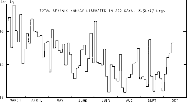 |
Figure 3. Seismic energy released by the Mehetia swarm (3-day intervals), 6 March-early December 1981. Courtesy of J. Talandier. |
By late October, more than 3,000 local events of magnitude 0.9 (ML) or stronger had been recorded. Of these, about 30 were stronger than ML 3.0, including magnitude 4.0 and 4.3 shocks. Because of the detection limits (usually about ML 1.1, but weaker seismicity is sometimes recorded during periods of lesser microseismic noise) for events in the Mehetia area (~140 km from the nearest Tahitian net station), harmonic tremor, if any, would probably not be recorded. Talandier's extrapolation of the well-defined frequency-magnitude relationship indicates that about 50,000 events stronger than ML 0.1 have probably occurred during the swarm. Talandier also notes that the Mehetia swarm and seismicity associated with Hawaiian volcanoes showed similarities in number and magnitude of events and seismogram characteristics, as well as the detection of long-period waves that could be generated by events occurring beneath a magma chamber. No surface volcanic activity has been reported at Mehetia. The island is uninhabited, working conditions there are difficult, and no geologist has visited the area recently.
Mehetia is a well-defined cone about 1,500 m in diameter and 435 m high, with a 200-m-diameter crater at the summit. No historic eruptions have been reported, but the limited erosion of the crater and flanks, lack of vegetation at the summit, and Tahitian legends of "big fires" all indicate that eruptions probably took place less than 2,000 years ago.
Information Contacts: J.M. Talandier, Lab. de Géophysique, Tahiti.
Seismic activity stops
Seismic activity that began in March 1981 ceased in December. Only a few low-energy events per month have been recorded since. Bathymetric reconnaissance around the island found evidence of an elliptical opening at 1,700 m below sea level on the SE flank, in the same location as the initial events of the earthquake swarm. RSP scientists interpreted the opening as a possible crater and the activity as a magmatic intrusion or eruption.
Information Contacts: J.M. Talandier, Lab. de Géophysique, Tahiti.
|
|
||||||||||||||||||||||||||||
There is data available for 0 confirmed eruptive period.
[ 1981 Mar 5 - 1981 Dec 16 ± 15 days ] Uncertain Eruption
| Episode 1 | Uncertain | SE of Mehetia (-1700 m?) | ||||||||||||||||||||||||||||
|---|---|---|---|---|---|---|---|---|---|---|---|---|---|---|---|---|---|---|---|---|---|---|---|---|---|---|---|---|---|
| 1981 Mar 5 - 1981 Dec 16 ± 15 days | Evidence from Unknown | ||||||||||||||||||||||||||||
| An earthquake swarm centered near a possible crater at 1,700 m depth on the SE flank of the island is thought to be due to magmatic intrusion or submarine eruption. | |||||||||||||||||||||||||||||
|
List of 4 Events for Episode 1 at SE of Mehetia (-1700 m?)
|
|||||||||||||||||||||||||||||
This compilation of synonyms and subsidiary features may not be comprehensive. Features are organized into four major categories: Cones, Craters, Domes, and Thermal Features. Synonyms of features appear indented below the primary name. In some cases additional feature type, elevation, or location details are provided.
Synonyms |
| Meetia | Meketia |
There are no samples for Mehetia in the Smithsonian's NMNH Department of Mineral Sciences Rock and Ore collection.
| Copernicus Browser | The Copernicus Browser replaced the Sentinel Hub Playground browser in 2023, to provide access to Earth observation archives from the Copernicus Data Space Ecosystem, the main distribution platform for data from the EU Copernicus missions. |
| MIROVA | Middle InfraRed Observation of Volcanic Activity (MIROVA) is a near real time volcanic hot-spot detection system based on the analysis of MODIS (Moderate Resolution Imaging Spectroradiometer) data. In particular, MIROVA uses the Middle InfraRed Radiation (MIR), measured over target volcanoes, in order to detect, locate and measure the heat radiation sourced from volcanic activity. |
| MODVOLC Thermal Alerts | Using infrared satellite Moderate Resolution Imaging Spectroradiometer (MODIS) data, scientists at the Hawai'i Institute of Geophysics and Planetology, University of Hawai'i, developed an automated system called MODVOLC to map thermal hot-spots in near real time. For each MODIS image, the algorithm automatically scans each 1 km pixel within it to check for high-temperature hot-spots. When one is found the date, time, location, and intensity are recorded. MODIS looks at every square km of the Earth every 48 hours, once during the day and once during the night, and the presence of two MODIS sensors in space allows at least four hot-spot observations every two days. Each day updated global maps are compiled to display the locations of all hot spots detected in the previous 24 hours. There is a drop-down list with volcano names which allow users to 'zoom-in' and examine the distribution of hot-spots at a variety of spatial scales. |
|
WOVOdat
Single Volcano View Temporal Evolution of Unrest Side by Side Volcanoes |
WOVOdat is a database of volcanic unrest; instrumentally and visually recorded changes in seismicity, ground deformation, gas emission, and other parameters from their normal baselines. It is sponsored by the World Organization of Volcano Observatories (WOVO) and presently hosted at the Earth Observatory of Singapore.
GVMID Data on Volcano Monitoring Infrastructure The Global Volcano Monitoring Infrastructure Database GVMID, is aimed at documenting and improving capabilities of volcano monitoring from the ground and space. GVMID should provide a snapshot and baseline view of the techniques and instrumentation that are in place at various volcanoes, which can be use by volcano observatories as reference to setup new monitoring system or improving networks at a specific volcano. These data will allow identification of what monitoring gaps exist, which can be then targeted by remote sensing infrastructure and future instrument deployments. |
| Volcanic Hazard Maps | The IAVCEI Commission on Volcanic Hazards and Risk has a Volcanic Hazard Maps database designed to serve as a resource for hazard mappers (or other interested parties) to explore how common issues in hazard map development have been addressed at different volcanoes, in different countries, for different hazards, and for different intended audiences. In addition to the comprehensive, searchable Volcanic Hazard Maps Database, this website contains information about diversity of volcanic hazard maps, illustrated using examples from the database. This site is for educational purposes related to volcanic hazard maps. Hazard maps found on this website should not be used for emergency purposes. For the most recent, official hazard map for a particular volcano, please seek out the proper institutional authorities on the matter. |
| IRIS seismic stations/networks | Incorporated Research Institutions for Seismology (IRIS) Data Services map showing the location of seismic stations from all available networks (permanent or temporary) within a radius of 0.18° (about 20 km at mid-latitudes) from the given location of Mehetia. Users can customize a variety of filters and options in the left panel. Note that if there are no stations are known the map will default to show the entire world with a "No data matched request" error notice. |
| UNAVCO GPS/GNSS stations | Geodetic Data Services map from UNAVCO showing the location of GPS/GNSS stations from all available networks (permanent or temporary) within a radius of 20 km from the given location of Mehetia. Users can customize the data search based on station or network names, location, and time window. Requires Adobe Flash Player. |
| DECADE Data | The DECADE portal, still in the developmental stage, serves as an example of the proposed interoperability between The Smithsonian Institution's Global Volcanism Program, the Mapping Gas Emissions (MaGa) Database, and the EarthChem Geochemical Portal. The Deep Earth Carbon Degassing (DECADE) initiative seeks to use new and established technologies to determine accurate global fluxes of volcanic CO2 to the atmosphere, but installing CO2 monitoring networks on 20 of the world's 150 most actively degassing volcanoes. The group uses related laboratory-based studies (direct gas sampling and analysis, melt inclusions) to provide new data for direct degassing of deep earth carbon to the atmosphere. |
| Large Eruptions of Mehetia | Information about large Quaternary eruptions (VEI >= 4) is cataloged in the Large Magnitude Explosive Volcanic Eruptions (LaMEVE) database of the Volcano Global Risk Identification and Analysis Project (VOGRIPA). |
| EarthChem | EarthChem develops and maintains databases, software, and services that support the preservation, discovery, access and analysis of geochemical data, and facilitate their integration with the broad array of other available earth science parameters. EarthChem is operated by a joint team of disciplinary scientists, data scientists, data managers and information technology developers who are part of the NSF-funded data facility Integrated Earth Data Applications (IEDA). IEDA is a collaborative effort of EarthChem and the Marine Geoscience Data System (MGDS). |


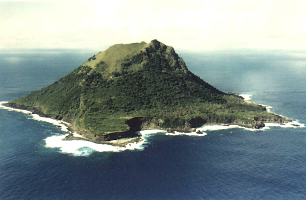
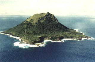 The 1.5-km-wide, steep-sided island of Meheti’a, seen here from the south, is the youngest and SE-most of the Society Islands. Wave erosion has exposed older lava flows, leaving steep cliffs that overlie coral reefs.