Ice cap forms at summit
For the first time this century a seasonal ice cover was observed at the summit. The ice cover was seen on the N and W faces from February 1993 through the end of May. The primary source of water for Puebla is runoff from Malinche; it is not known what effect the development of an ice cap will have on the water supply. Glacial deposits have been identified on the NE flanks of the volcano. Seismicity has been monitored daily from a station at Puebla University since 1986, but no events have been detected.
Reference. von Erfa, A., 1979, Geología de la Cuenca Puebla Tlaxcala: Comunicaciones No. 5, Fundación Alemana para la Investigación Científica.
Information Contacts: Alejandro Rivera Dominguez, Dept de Ciencias de la Tierra, Univ Autonoma de Puebla, Apartado 1572, C.P. 7200, Puebla, México.
The Global Volcanism Program has no Weekly Reports available for La Malinche.
Reports are organized chronologically and indexed below by Month/Year (Publication Volume:Number), and include a one-line summary. Click on the index link or scroll down to read the reports.
Ice cap forms at summit
For the first time this century a seasonal ice cover was observed at the summit. The ice cover was seen on the N and W faces from February 1993 through the end of May. The primary source of water for Puebla is runoff from Malinche; it is not known what effect the development of an ice cap will have on the water supply. Glacial deposits have been identified on the NE flanks of the volcano. Seismicity has been monitored daily from a station at Puebla University since 1986, but no events have been detected.
Reference. von Erfa, A., 1979, Geología de la Cuenca Puebla Tlaxcala: Comunicaciones No. 5, Fundación Alemana para la Investigación Científica.
Information Contacts: Alejandro Rivera Dominguez, Dept de Ciencias de la Tierra, Univ Autonoma de Puebla, Apartado 1572, C.P. 7200, Puebla, México.
|
|
||||||||||||||||||||||||||
There is data available for 7 confirmed eruptive periods.
1170 BCE ± 50 years Confirmed Eruption (Explosive / Effusive)
| Episode 1 | Eruption (Explosive / Effusive) | ||||||||||||||||||||||||||||||||||
|---|---|---|---|---|---|---|---|---|---|---|---|---|---|---|---|---|---|---|---|---|---|---|---|---|---|---|---|---|---|---|---|---|---|---|
| 1170 BCE ± 50 years - Unknown | Evidence from Isotopic: 14C (uncalibrated) | |||||||||||||||||||||||||||||||||
|
List of 5 Events for Episode 1
|
||||||||||||||||||||||||||||||||||
5580 BCE ± 300 years Confirmed Eruption (Explosive / Effusive)
| Episode 1 | Eruption (Explosive / Effusive) | |||||||||||||||||||||||||||||
|---|---|---|---|---|---|---|---|---|---|---|---|---|---|---|---|---|---|---|---|---|---|---|---|---|---|---|---|---|---|
| 5580 BCE ± 300 years - Unknown | Evidence from Isotopic: 14C (uncalibrated) | ||||||||||||||||||||||||||||
|
List of 4 Events for Episode 1
|
|||||||||||||||||||||||||||||
5870 BCE ± 100 years Confirmed Eruption (Explosive / Effusive)
| Episode 1 | Eruption (Explosive / Effusive) | ||||||||||||||||||||||||
|---|---|---|---|---|---|---|---|---|---|---|---|---|---|---|---|---|---|---|---|---|---|---|---|---|
| 5870 BCE ± 100 years - Unknown | Evidence from Isotopic: 14C (uncalibrated) | |||||||||||||||||||||||
|
List of 3 Events for Episode 1
|
||||||||||||||||||||||||
6120 BCE ± 100 years Confirmed Eruption (Explosive / Effusive)
| Episode 1 | Eruption (Explosive / Effusive) | ||||||||||||||||||||||||
|---|---|---|---|---|---|---|---|---|---|---|---|---|---|---|---|---|---|---|---|---|---|---|---|---|
| 6120 BCE ± 100 years - Unknown | Evidence from Isotopic: 14C (uncalibrated) | |||||||||||||||||||||||
|
List of 3 Events for Episode 1
|
||||||||||||||||||||||||
6310 BCE ± 75 years Confirmed Eruption (Explosive / Effusive)
| Episode 1 | Eruption (Explosive / Effusive) | ||||||||||||||||||||||||
|---|---|---|---|---|---|---|---|---|---|---|---|---|---|---|---|---|---|---|---|---|---|---|---|---|
| 6310 BCE ± 75 years - Unknown | Evidence from Isotopic: 14C (uncalibrated) | |||||||||||||||||||||||
|
List of 3 Events for Episode 1
|
||||||||||||||||||||||||
6710 BCE ± 200 years Confirmed Eruption (Explosive / Effusive)
| Episode 1 | Eruption (Explosive / Effusive) | ||||||||||||||||||||||||
|---|---|---|---|---|---|---|---|---|---|---|---|---|---|---|---|---|---|---|---|---|---|---|---|---|
| 6710 BCE ± 200 years - Unknown | Evidence from Isotopic: 14C (uncalibrated) | |||||||||||||||||||||||
|
List of 3 Events for Episode 1
|
||||||||||||||||||||||||
6890 BCE ± 500 years Confirmed Eruption (Explosive / Effusive)
| Episode 1 | Eruption (Explosive / Effusive) | |||||||||||||||||||||||||||||
|---|---|---|---|---|---|---|---|---|---|---|---|---|---|---|---|---|---|---|---|---|---|---|---|---|---|---|---|---|---|
| 6890 BCE ± 500 years - Unknown | Evidence from Isotopic: 14C (uncalibrated) | ||||||||||||||||||||||||||||
|
List of 4 Events for Episode 1
|
|||||||||||||||||||||||||||||
This compilation of synonyms and subsidiary features may not be comprehensive. Features are organized into four major categories: Cones, Craters, Domes, and Thermal Features. Synonyms of features appear indented below the primary name. In some cases additional feature type, elevation, or location details are provided.
Synonyms |
||||
| Metlalcueyatle | Matlalcueye | Matlacueyatl | ||||
Craters |
||||
| Feature Name | Feature Type | Elevation | Latitude | Longitude |
| Xalapasco | Maar | 2754 m | 19° 15' 35.00" N | 97° 55' 37.00" W |
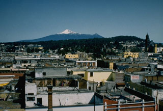 The summit of Malinche volcano rises beyond the historical city of Puebla. Pleistocene glaciers have eroded the flanks of the volcano, but at least one of several tuff cones and explosion craters on the flanks is of Holocene age.
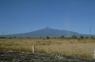 Volcán la Malinche, seen here from the south, derives its name from a Mayan woman who became the wife, aide, and interpreter of the Spanish explorer Cortés. The Spanish mispronounced the woman's name Malintzin as Malinche.
 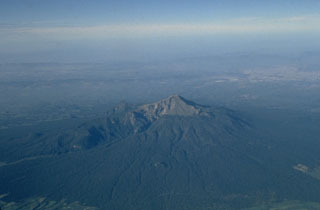 Volcán la Malinche, seen here in an aerial view from the NE, is an eroded edifice with deep canyons from glacial erosion, located NE of the city of Puebla and between the Popocatépetl-Iztaccíhuatl and Orizaba-Cofre de Perote volcanic ranges. Much of the edifice was constructed during the Pleistocene but there are Holocene tephra layers of Holocene age.
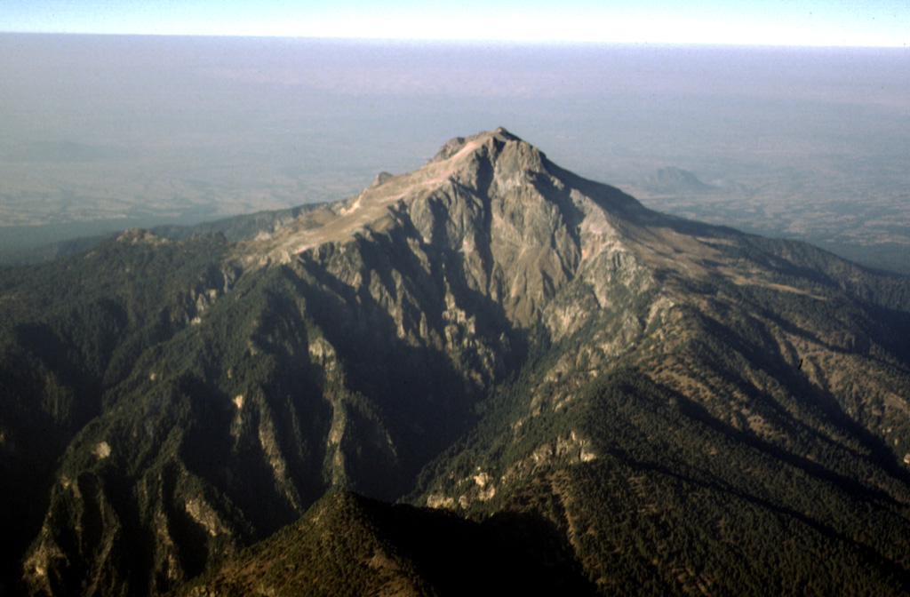
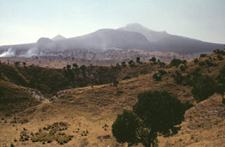 The NE flank of Volcán la Malinche contains deep glacially carved canyons and the craters in the foreground are part of the Xalapaxco tuff cone complex. Xalapaxco means "vessel or container made of sand" in the Aztec Nahuatl language. The tuff cone contains ten overlapping craters influenced by changes in water and magma supply rates during the course of an eruption. The tuff cone was erupted through alluvial fan deposits consisting of reworked fluvial and glacial deposits on the lower flank of Malinche.
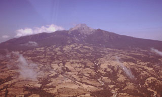 Broad alluvial fans composed of fluvial, glacial, and volcaniclastic sediments surround La Malinche volcano. The circular volcano is dissected by radial drainages on all sides. During attempts to reconstruct the Quaternary glacial history of Mexican volcanoes a yellowish-red pumice layer that extends around Malinche volcano was dated to between about 12,100 and 7,650 years old.
 Malinche is located between the Popocatépetl-Iztaccíhuatl and Orizaba-Cofre de Perote volcanic ranges. The edifice is largely Pleistocene in age and is seen here in an aerial view from the SE. The canyons on the flanks are a result of glacial erosion. Holocene lahars from La Malinche associated with an eruption about 3,100 years ago reached the Puebla basin and affected precolumbian settlements.
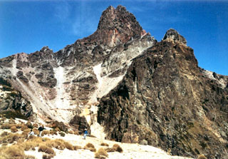 The summit pinnacle of La Malinche is seen here from the south. The summit consists of several lava domes, one of which filled the vent from the last major eruption of the volcano about 3,100 years ago. Note the people in the left foreground for scale.
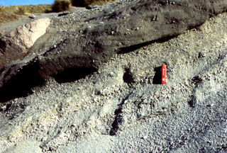 The products of the last major eruption of La Malinche that occurred about 3,100 years ago are exposed around the summit area and consist of a weakly stratified pumiceous ash and fine lapilli layer, along with associated pyroclastic flow and lahar deposits. Lahars originating from La Malinche reached the Puebla basin and contain pottery fragments, indicating that nearby communities were affected by the eruption. The pocket knife provides scale.
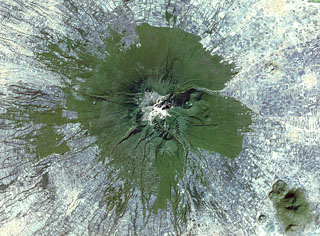 Farmlands surround La Malinche volcano NE of the city of Puebla in this 1999 Landsat satellite image (N is at the top; this image is approximately 30 km across). Deep erosional gullies have formed down the flanks, and the 1.5-km-diameter late-Pleistocene Xalapasco maar complex is on the lower ENE Flank about 11 km from the summit.
 There are no samples for La Malinche in the Smithsonian's NMNH Department of Mineral Sciences Rock and Ore collection.
| Copernicus Browser | The Copernicus Browser replaced the Sentinel Hub Playground browser in 2023, to provide access to Earth observation archives from the Copernicus Data Space Ecosystem, the main distribution platform for data from the EU Copernicus missions. |
| MIROVA | Middle InfraRed Observation of Volcanic Activity (MIROVA) is a near real time volcanic hot-spot detection system based on the analysis of MODIS (Moderate Resolution Imaging Spectroradiometer) data. In particular, MIROVA uses the Middle InfraRed Radiation (MIR), measured over target volcanoes, in order to detect, locate and measure the heat radiation sourced from volcanic activity. |
| MODVOLC Thermal Alerts | Using infrared satellite Moderate Resolution Imaging Spectroradiometer (MODIS) data, scientists at the Hawai'i Institute of Geophysics and Planetology, University of Hawai'i, developed an automated system called MODVOLC to map thermal hot-spots in near real time. For each MODIS image, the algorithm automatically scans each 1 km pixel within it to check for high-temperature hot-spots. When one is found the date, time, location, and intensity are recorded. MODIS looks at every square km of the Earth every 48 hours, once during the day and once during the night, and the presence of two MODIS sensors in space allows at least four hot-spot observations every two days. Each day updated global maps are compiled to display the locations of all hot spots detected in the previous 24 hours. There is a drop-down list with volcano names which allow users to 'zoom-in' and examine the distribution of hot-spots at a variety of spatial scales. |
|
WOVOdat
Single Volcano View Temporal Evolution of Unrest Side by Side Volcanoes |
WOVOdat is a database of volcanic unrest; instrumentally and visually recorded changes in seismicity, ground deformation, gas emission, and other parameters from their normal baselines. It is sponsored by the World Organization of Volcano Observatories (WOVO) and presently hosted at the Earth Observatory of Singapore.
GVMID Data on Volcano Monitoring Infrastructure The Global Volcano Monitoring Infrastructure Database GVMID, is aimed at documenting and improving capabilities of volcano monitoring from the ground and space. GVMID should provide a snapshot and baseline view of the techniques and instrumentation that are in place at various volcanoes, which can be use by volcano observatories as reference to setup new monitoring system or improving networks at a specific volcano. These data will allow identification of what monitoring gaps exist, which can be then targeted by remote sensing infrastructure and future instrument deployments. |
| Volcanic Hazard Maps | The IAVCEI Commission on Volcanic Hazards and Risk has a Volcanic Hazard Maps database designed to serve as a resource for hazard mappers (or other interested parties) to explore how common issues in hazard map development have been addressed at different volcanoes, in different countries, for different hazards, and for different intended audiences. In addition to the comprehensive, searchable Volcanic Hazard Maps Database, this website contains information about diversity of volcanic hazard maps, illustrated using examples from the database. This site is for educational purposes related to volcanic hazard maps. Hazard maps found on this website should not be used for emergency purposes. For the most recent, official hazard map for a particular volcano, please seek out the proper institutional authorities on the matter. |
| IRIS seismic stations/networks | Incorporated Research Institutions for Seismology (IRIS) Data Services map showing the location of seismic stations from all available networks (permanent or temporary) within a radius of 0.18° (about 20 km at mid-latitudes) from the given location of La Malinche. Users can customize a variety of filters and options in the left panel. Note that if there are no stations are known the map will default to show the entire world with a "No data matched request" error notice. |
| UNAVCO GPS/GNSS stations | Geodetic Data Services map from UNAVCO showing the location of GPS/GNSS stations from all available networks (permanent or temporary) within a radius of 20 km from the given location of La Malinche. Users can customize the data search based on station or network names, location, and time window. Requires Adobe Flash Player. |
| DECADE Data | The DECADE portal, still in the developmental stage, serves as an example of the proposed interoperability between The Smithsonian Institution's Global Volcanism Program, the Mapping Gas Emissions (MaGa) Database, and the EarthChem Geochemical Portal. The Deep Earth Carbon Degassing (DECADE) initiative seeks to use new and established technologies to determine accurate global fluxes of volcanic CO2 to the atmosphere, but installing CO2 monitoring networks on 20 of the world's 150 most actively degassing volcanoes. The group uses related laboratory-based studies (direct gas sampling and analysis, melt inclusions) to provide new data for direct degassing of deep earth carbon to the atmosphere. |
| Large Eruptions of La Malinche | Information about large Quaternary eruptions (VEI >= 4) is cataloged in the Large Magnitude Explosive Volcanic Eruptions (LaMEVE) database of the Volcano Global Risk Identification and Analysis Project (VOGRIPA). |
| EarthChem | EarthChem develops and maintains databases, software, and services that support the preservation, discovery, access and analysis of geochemical data, and facilitate their integration with the broad array of other available earth science parameters. EarthChem is operated by a joint team of disciplinary scientists, data scientists, data managers and information technology developers who are part of the NSF-funded data facility Integrated Earth Data Applications (IEDA). IEDA is a collaborative effort of EarthChem and the Marine Geoscience Data System (MGDS). |

