No visible fumarolic activity; strong sulfur odor near sumit craters
Geologists visited the summit 16, 17, and 18 February. There was no visible fumarolic activity around the summit, or in the explosion craters from the volcano's last eruption in 1972. The geologists smelled a strong sulfur odor in the immediate vicinity of the summit craters.
Information Contacts: T. Bornhorst and C. Chesner, Michigan Tech. Univ.
The Global Volcanism Program has no Weekly Reports available for Acatenango.
Reports are organized chronologically and indexed below by Month/Year (Publication Volume:Number), and include a one-line summary. Click on the index link or scroll down to read the reports.
Eruption from three central vents in mid-November; first activity since 1927
Card 1513 (19 December 1972) Eruption from three central vents in mid-November; first activity since 1927
R. Stoiber reported the following on 18 December 1972. "The volcano Acatenango started erupting on approximately 13 November 1972 for the first time since 19 May 1927. Ascents by Dartmouth teams have documented a deepened crater and five active vents located in the saddle between the two peaks of Acatenago. These vents are situated on the N-S line along the axis of the peaks of Acatenango and the adjacent volcano Fuego. On 5 December 1972 the three central vents were ejecting, steam, ash, and gases included H2S and SO2. Five to 10 cm of ash covers the summit area. No ash had fallen outside this zone. New white sublimates, possibly gypsum, were noted. A prior ascent on 30 October 1972 had revealed only weak fumarolic activity. Observations continue."
Information Contacts: Samuel Bonis, Instituto Geografico Nacional, Guatemala; Richard Stoiber, Dartmouth College, USA
No visible fumarolic activity; strong sulfur odor near sumit craters
Geologists visited the summit 16, 17, and 18 February. There was no visible fumarolic activity around the summit, or in the explosion craters from the volcano's last eruption in 1972. The geologists smelled a strong sulfur odor in the immediate vicinity of the summit craters.
Information Contacts: T. Bornhorst and C. Chesner, Michigan Tech. Univ.
|
|
||||||||||||||||||||||||||||
There is data available for 8 confirmed eruptive periods.
1972 Nov 12 - 1972 Dec 16 ± 15 days Confirmed Eruption (Explosive / Effusive) VEI: 1
| Episode 1 | Eruption (Explosive / Effusive) | Pico Central-Yepocapa saddle | ||||||||||||||||||||||||||||
|---|---|---|---|---|---|---|---|---|---|---|---|---|---|---|---|---|---|---|---|---|---|---|---|---|---|---|---|---|---|
| 1972 Nov 12 - 1972 Dec 16 ± 15 days | Evidence from Observations: Reported | ||||||||||||||||||||||||||||
|
List of 4 Events for Episode 1 at Pico Central-Yepocapa saddle
|
|||||||||||||||||||||||||||||
1926 Aug - 1927 May 19 Confirmed Eruption (Explosive / Effusive) VEI: 2
| Episode 1 | Eruption (Explosive / Effusive) | Pico Central | |||||||||||||||||||||||||||||||||
|---|---|---|---|---|---|---|---|---|---|---|---|---|---|---|---|---|---|---|---|---|---|---|---|---|---|---|---|---|---|---|---|---|---|---|
| 1926 Aug - 1927 May 19 | Evidence from Observations: Reported | |||||||||||||||||||||||||||||||||
|
List of 5 Events for Episode 1 at Pico Central
|
||||||||||||||||||||||||||||||||||
1924 Dec 18 - 1925 Jun 7 Confirmed Eruption (Explosive / Effusive) VEI: 3
| Episode 1 | Eruption (Explosive / Effusive) | North slope of Pico Central | ||||||||||||||||||||||||||||||||||||||
|---|---|---|---|---|---|---|---|---|---|---|---|---|---|---|---|---|---|---|---|---|---|---|---|---|---|---|---|---|---|---|---|---|---|---|---|---|---|---|---|
| 1924 Dec 18 - 1925 Jun 7 | Evidence from Observations: Reported | ||||||||||||||||||||||||||||||||||||||
|
List of 6 Events for Episode 1 at North slope of Pico Central
|
|||||||||||||||||||||||||||||||||||||||
1450 ± 50 years Confirmed Eruption (Explosive / Effusive)
| Episode 1 | Eruption (Explosive / Effusive) | ||||||||||||||
|---|---|---|---|---|---|---|---|---|---|---|---|---|---|---|
| 1450 ± 50 years - Unknown | Evidence from Correlation: Anthropology | |||||||||||||
|
List of 1 Events for Episode 1
|
||||||||||||||
0090 ± 100 years Confirmed Eruption (Explosive / Effusive)
| Episode 1 | Eruption (Explosive / Effusive) | Pico Central | ||||||||||||||||||
|---|---|---|---|---|---|---|---|---|---|---|---|---|---|---|---|---|---|---|---|
| 0090 ± 100 years - Unknown | Evidence from Isotopic: 14C (uncalibrated) | ||||||||||||||||||
|
List of 2 Events for Episode 1 at Pico Central
|
|||||||||||||||||||
0260 BCE ± 75 years Confirmed Eruption (Explosive / Effusive)
| Episode 1 | Eruption (Explosive / Effusive) | Pico Central | ||||||||||||||||||
|---|---|---|---|---|---|---|---|---|---|---|---|---|---|---|---|---|---|---|---|
| 0260 BCE ± 75 years - Unknown | Evidence from Isotopic: 14C (uncalibrated) | ||||||||||||||||||
|
List of 2 Events for Episode 1 at Pico Central
|
|||||||||||||||||||
0370 BCE ± 200 years Confirmed Eruption (Explosive / Effusive)
| Episode 1 | Eruption (Explosive / Effusive) | Pico Central | |||||||||||||||||||||||
|---|---|---|---|---|---|---|---|---|---|---|---|---|---|---|---|---|---|---|---|---|---|---|---|---|
| 0370 BCE ± 200 years - Unknown | Evidence from Isotopic: 14C (uncalibrated) | |||||||||||||||||||||||
|
List of 3 Events for Episode 1 at Pico Central
|
||||||||||||||||||||||||
2710 BCE ± 75 years Confirmed Eruption (Explosive / Effusive)
| Episode 1 | Eruption (Explosive / Effusive) | Yepocapa | |||||||||||||||||||||||||||||||||
|---|---|---|---|---|---|---|---|---|---|---|---|---|---|---|---|---|---|---|---|---|---|---|---|---|---|---|---|---|---|---|---|---|---|---|
| 2710 BCE ± 75 years - Unknown | Evidence from Isotopic: 14C (uncalibrated) | |||||||||||||||||||||||||||||||||
|
List of 5 Events for Episode 1 at Yepocapa
|
||||||||||||||||||||||||||||||||||
This compilation of synonyms and subsidiary features may not be comprehensive. Features are organized into four major categories: Cones, Craters, Domes, and Thermal Features. Synonyms of features appear indented below the primary name. In some cases additional feature type, elevation, or location details are provided.
Synonyms |
||||
| Mayor, Pico | Central, Pico | ||||
Cones |
||||
| Feature Name | Feature Type | Elevation | Latitude | Longitude |
| Yepocapa
Chico, Pico Tres Hermanas Tres Marías |
Stratovolcano | 3820 m | 14° 30' 29.00" N | 90° 52' 23.00" W |
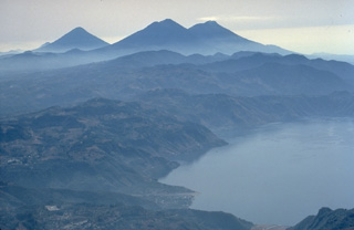 The twin volcanoes of Acatenango (left) and Fuego rise in the center beyond Lake Atitlán, with the conical peak of Agua volcano to their left. Lake Atitlán fills the latest of three large calderas produced during the Pleistocene at Atitlán. A steam plume originates from the summit of Fuego, one of Guatemala's most active volcanoes.
 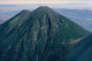 Acatenango, forming a twin volcano with Volcán Fuego to the south, itself has two summits. Activity at Yepocapa (left), the northern summit of Acatenango, ended about 20,000 years ago, after which the southern and highest cone, Pico Mayor, was constructed. The first well-documented eruptions of Acatenango took place from 1924 to 1927, although earlier historical eruptions may have occurred. This aerial view is from the SW.
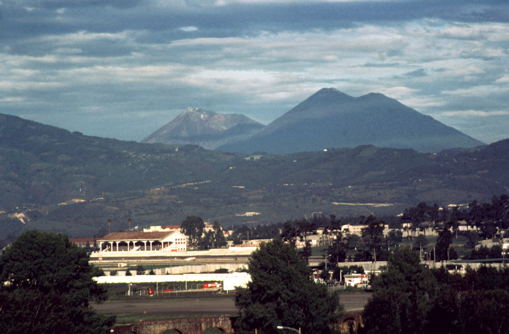
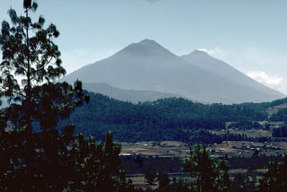 The Acatenango-Fuego complex is seen here from the NW. A gas plume drifts from the summit of Fuego (right), beyond Acatenango (center). Like other N-S-trending volcanic chains in the Guatemalan highlands, activity at the Acatenango-Fuego chain migrated to the south. Yepocapa, the northernmost summit of Acatenango, was active from about 70,000 to 20,000 years ago, after which Acatenango's northern Pico Mayor was constructed. The frequently active Fuego volcano formed during the Holocene.
 The upper SE flanks of Fuego (left) and Acatenango (right) are seen here, with their summits that lie only 3 km apart along a N-S line. The modern Fuego edifice was constructed within a scarp left by collapse of the ancestral Mesata, whose flank appears to the right of the summit towards the saddle between the two.
 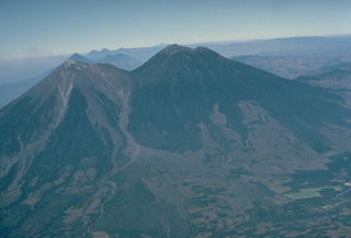 The paired volcanoes of Fuego (left) and Acatenango, seen here in profile from the ESE, illustrate the N-S progression of volcanism that is typical of paired volcanoes in Guatemala and México. Activity at Yepocapa (right), the lower northern summit of Acatenango, ended about 20,000 years ago, after which Acatenango's highest cone, Pico Mayor, was built. Activity then again migrated southward to build Meseta volcano, a remnant of which forms the shoulder left of the saddle between Acatenango and Fuego. Lastly, modern Fuego was constructed south of Meseta volcano.
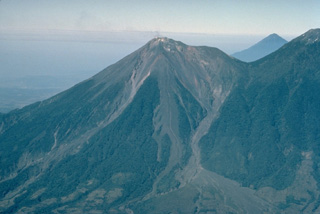 Volcán Fuego, one of Central America's most active volcanoes, is one of three large stratovolcanoes overlooking Guatemala's former capital, Antigua. The scarp of an older edifice, Meseta, forms the shoulder between between Fuego and its twin volcano, Acatenango. This view from the SE also shows Atitlán volcano above the saddle between Fuego and Acantenango. Vigorous historical eruptions have been recorded at Fuego since 1524. They have produced major ashfalls, along with occasional pyroclastic flows and lava flows.
 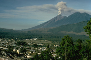 An ash column rises above the summit of Fuego volcano in early December 1974 with the city of Antigua in the foreground. This relatively minor activity took place near the end of one of Fuego's largest historical eruptions, which began in October. The twin summits of Acatenango, Pico Mayer (right) and Yepocapa (left), appear at the upper right.
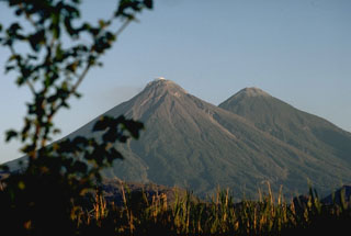 Fuego (left) and Acatenango are two of several paired volcanoes in Guatemala. Activity from the Pleistocene-Holocene Acatenango has continued only sporadically into historical time, but Fuego is one of the most active volcanoes in Guatemala with about 60 historical eruptions.
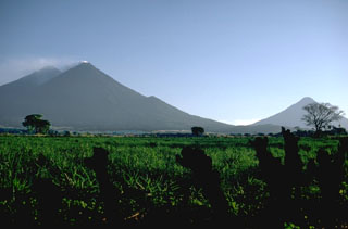 Three stratovolcanoes tower more than 3,500 m above the Guatemala Pacific coastal plain. Acatenango is the highest of the three, a small gas plume drifts from the summit of Fuego, and Volcán de Agua to the far right rises above a low saddle between it and Volcán de Fuego.
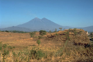 The hummocky surface in the foreground in front of the Fuego and Acatenango volcanoes in Guatemala is a massive debris-avalanche deposit in Escuintla that was produced by partial collapse of the volcanic complex sometime during the late Pleistocene to early Holocene. This is the largest known debris avalanche in Guatemala; it has an estimated volume of about 15 km3 and traveled about 50 km. For the last 30 km, the avalanche traveled over flat slopes of less than 1 degree, illustrating the extremely high mobility of volcanic debris avalanches.
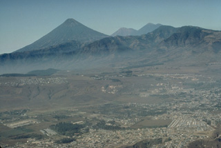 The beautifully symmetrical Agua volcano forms a prominent backdrop to Guatemala City in the foreground. The twin volcanoes of Fuego (left) and Acatenango (right) appear to the right of Agua in this 1983 view from the NE. No historical eruptions are known of Agua volcano, despite its youthful profile.
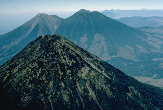 The forested summit of symmetrical Agua volcano appears in the foreground with the twin volcanoes of Fuego (left) and Acatenango (right) in the background. The three stratovolcanoes overlook the historical city of Antigua Guatemala, whose outskirts appear on the right. Agua has had no historical eruptions, in contrast to Acatenango and especially Fuego, which is one of the most active volcanoes of Guatemala. This 1983 aerial view is from the west.
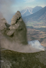 An explosion from MacKenney crater on Pacaya volcano ejects a dark, ash-rich column and individual blocks that are sometimes incandescent even during daylight hours. This December 1974 photo shows Fuego (left) and Acatenango (right) volcanoes in the background, behind the sloping flanks of Agua volcano.
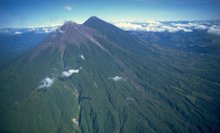 Fuego (left) and Acatenango are seen here from the SSE in 1994. The two edifices erupted from four major vents along a 5-km-long N-S trend, with the focus of volcanic activity progressively shifting to the south. The modern Fuego edifice is constructed within the collapse scar of the ancestral Mesata edifice, located between it and Acatenango.
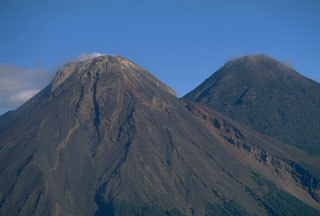 Fuego and Acatenango are seen here from the SE and are result of eruptions along a N-S line that moved progressively towards the south. The gully on the righthand side of Fuego is the rim of a scarp produced by the collapse of ancestral Meseta volcano, which preceded the growth of the modern Fuego edifice.
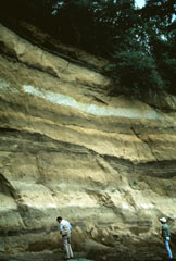 A thick sequence of tephra layers, mostly from Acatenango, is exposed on the northern flank. Yepocapa, the northernmost of the two volcanic centers forming Acatenango, formed between about 70,000 and 43,000 years ago. Its major period of eruptive activity ended about 20,000 years ago, after which the activity of the southernmost center, Pico Mayor, commenced.
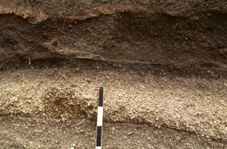 A tephra layer from Acatenango is exposed NE of the volcano along the road between Antigua and Yepocapa. Pottery fragments within the tephra layer were dated between 1,400 and 1,500 CE. Most Holocene eruptions from Acatenango originated from Pico Mayor, the southernmost and highest of the two peaks. The scale bar marks 10 cm intervals.
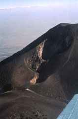 This elongate crater is along the northern flank of Pico Mayor, the summit of Acatenango. The first well-documented eruption of Acatenango took place from this N-flank vent beginning 18 December 1924. The eruption continued until 7 June 1925. On 14 March 1925 ash fell as far away as Pochuta.
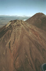 The flanks of Fuego are seen here in an aerial view from the SE in 1978 with Acatenango to the right. Over the formation of these volcanoes the activity began at the northern center, farthest away from the Central American trench (100 km S), and subsequently migrated to the south.
 Acatenango (right) is seen here with Fuego at the center in 1986. Volcán Acatenango was constructed during three eruptive periods post-dating the roughly 84,000-year-old Los Chocoyos Ash from Atitlán caldera. The eruptive period of Yepocapa, the northern peak of Acatenango, ceased about 20,000 years ago. The eruption of the southern and highest cone, Pico Mayor began at that time.
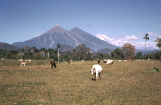 Fuego and Acatenango volcanoes tower more than 3.5 km above farmlands of the Pacific coastal plain. Edifice failure of these volcanoes has occurred in the direction of the coastal plain, producing major debris avalanches that reached as far as 50 km away.
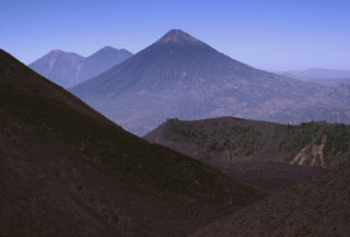 Volcán de Agua is in the center of this photo and lava flows from MacKenney cone form the slope in the foreground. They have filled in the moat of the Pacaya caldera almost to the level of the lower Cerro Chino crater rim, with the communication antennas along the summit in the midground. The two volcanoes on the left horizon are Fuego (left), one of the most active in Guatemala, and Acatenango (right).
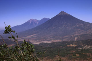 This view from Pacaya shows Fuego and Acatenango (left) and conical Volcán de Agua volcano (right). These impressive volcanoes all exceed 3.5 km in elevation and rise from near sea level on the Pacific coastal plain to the south. Volcanism at the Acatenango-Fuego pair has migrated southwards, and Fuego, its summit kept free of vegetation by frequent eruptions, is one of Guatemala's most active volcanoes.
The following 1 samples associated with this volcano can be found in the Smithsonian's NMNH Department of Mineral Sciences collections, and may be availble for research (contact the Rock and Ore Collections Manager). Catalog number links will open a window with more information.
| Catalog Number | Sample Description | Lava Source | Collection Date |
|---|---|---|---|
| NMNH 117395-7 | Lava | -- | 2 Feb 1980 |
| Copernicus Browser | The Copernicus Browser replaced the Sentinel Hub Playground browser in 2023, to provide access to Earth observation archives from the Copernicus Data Space Ecosystem, the main distribution platform for data from the EU Copernicus missions. |
| MIROVA | Middle InfraRed Observation of Volcanic Activity (MIROVA) is a near real time volcanic hot-spot detection system based on the analysis of MODIS (Moderate Resolution Imaging Spectroradiometer) data. In particular, MIROVA uses the Middle InfraRed Radiation (MIR), measured over target volcanoes, in order to detect, locate and measure the heat radiation sourced from volcanic activity. |
| MODVOLC Thermal Alerts | Using infrared satellite Moderate Resolution Imaging Spectroradiometer (MODIS) data, scientists at the Hawai'i Institute of Geophysics and Planetology, University of Hawai'i, developed an automated system called MODVOLC to map thermal hot-spots in near real time. For each MODIS image, the algorithm automatically scans each 1 km pixel within it to check for high-temperature hot-spots. When one is found the date, time, location, and intensity are recorded. MODIS looks at every square km of the Earth every 48 hours, once during the day and once during the night, and the presence of two MODIS sensors in space allows at least four hot-spot observations every two days. Each day updated global maps are compiled to display the locations of all hot spots detected in the previous 24 hours. There is a drop-down list with volcano names which allow users to 'zoom-in' and examine the distribution of hot-spots at a variety of spatial scales. |
|
WOVOdat
Single Volcano View Temporal Evolution of Unrest Side by Side Volcanoes |
WOVOdat is a database of volcanic unrest; instrumentally and visually recorded changes in seismicity, ground deformation, gas emission, and other parameters from their normal baselines. It is sponsored by the World Organization of Volcano Observatories (WOVO) and presently hosted at the Earth Observatory of Singapore.
GVMID Data on Volcano Monitoring Infrastructure The Global Volcano Monitoring Infrastructure Database GVMID, is aimed at documenting and improving capabilities of volcano monitoring from the ground and space. GVMID should provide a snapshot and baseline view of the techniques and instrumentation that are in place at various volcanoes, which can be use by volcano observatories as reference to setup new monitoring system or improving networks at a specific volcano. These data will allow identification of what monitoring gaps exist, which can be then targeted by remote sensing infrastructure and future instrument deployments. |
| Volcanic Hazard Maps | The IAVCEI Commission on Volcanic Hazards and Risk has a Volcanic Hazard Maps database designed to serve as a resource for hazard mappers (or other interested parties) to explore how common issues in hazard map development have been addressed at different volcanoes, in different countries, for different hazards, and for different intended audiences. In addition to the comprehensive, searchable Volcanic Hazard Maps Database, this website contains information about diversity of volcanic hazard maps, illustrated using examples from the database. This site is for educational purposes related to volcanic hazard maps. Hazard maps found on this website should not be used for emergency purposes. For the most recent, official hazard map for a particular volcano, please seek out the proper institutional authorities on the matter. |
| IRIS seismic stations/networks | Incorporated Research Institutions for Seismology (IRIS) Data Services map showing the location of seismic stations from all available networks (permanent or temporary) within a radius of 0.18° (about 20 km at mid-latitudes) from the given location of Acatenango. Users can customize a variety of filters and options in the left panel. Note that if there are no stations are known the map will default to show the entire world with a "No data matched request" error notice. |
| UNAVCO GPS/GNSS stations | Geodetic Data Services map from UNAVCO showing the location of GPS/GNSS stations from all available networks (permanent or temporary) within a radius of 20 km from the given location of Acatenango. Users can customize the data search based on station or network names, location, and time window. Requires Adobe Flash Player. |
| DECADE Data | The DECADE portal, still in the developmental stage, serves as an example of the proposed interoperability between The Smithsonian Institution's Global Volcanism Program, the Mapping Gas Emissions (MaGa) Database, and the EarthChem Geochemical Portal. The Deep Earth Carbon Degassing (DECADE) initiative seeks to use new and established technologies to determine accurate global fluxes of volcanic CO2 to the atmosphere, but installing CO2 monitoring networks on 20 of the world's 150 most actively degassing volcanoes. The group uses related laboratory-based studies (direct gas sampling and analysis, melt inclusions) to provide new data for direct degassing of deep earth carbon to the atmosphere. |
| Large Eruptions of Acatenango | Information about large Quaternary eruptions (VEI >= 4) is cataloged in the Large Magnitude Explosive Volcanic Eruptions (LaMEVE) database of the Volcano Global Risk Identification and Analysis Project (VOGRIPA). |
| EarthChem | EarthChem develops and maintains databases, software, and services that support the preservation, discovery, access and analysis of geochemical data, and facilitate their integration with the broad array of other available earth science parameters. EarthChem is operated by a joint team of disciplinary scientists, data scientists, data managers and information technology developers who are part of the NSF-funded data facility Integrated Earth Data Applications (IEDA). IEDA is a collaborative effort of EarthChem and the Marine Geoscience Data System (MGDS). |

