
The Global Volcanism Program has no activity reports available for San Pedro.
The Global Volcanism Program has no Weekly Reports available for San Pedro.
The Global Volcanism Program has no Bulletin Reports available for San Pedro.
|
|
||||||||||||||||||
The Global Volcanism Program is not aware of any Holocene eruptions from San Pedro. If this volcano has had large eruptions (VEI >= 4) prior to 12,000 years ago, information might be found on the San Pedro page in the LaMEVE (Large Magnitude Explosive Volcanic Eruptions) database, a part of the Volcano Global Risk Identification and Analysis Project (VOGRIPA).
This compilation of synonyms and subsidiary features may not be comprehensive. Features are organized into four major categories: Cones, Craters, Domes, and Thermal Features. Synonyms of features appear indented below the primary name. In some cases additional feature type, elevation, or location details are provided.
Cones |
||||
| Feature Name | Feature Type | Elevation | Latitude | Longitude |
| Chuichumil, Cerro | Cone | 2440 m | 14° 38' 53.00" N | 91° 17' 13.00" W |
| Chuicinivit, Cerro | Cone | 1695 m | 14° 39' 4.00" N | 91° 14' 20.00" W |
| Paquixten, Cerro | Cone | 2455 m | 14° 38' 31.00" N | 91° 17' 2.00" W |
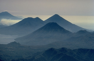 The twin volcanoes of Tolimán (left) and Atitlán (right) on the center skyline, along with San Pedro volcano in the foreground, rise above the southern shores of Lake Atitlán. This aerial view looking along the chain of stratovolcanoes stretching across Guatemala, also shows Fuego volcano at the upper left. The double-peaked Tolimán is somewhat older than the conical Atitlán volcano to its south.
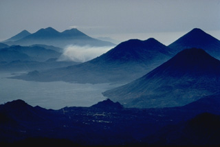 This dramatic photo looking SE down the axis of a chain of volcanoes extending across Guatemala shows six Quaternary volcanoes and one large caldera. Beginning in the right foreground are three volcanoes, San Pedro, the conical Atitlán, and Tolimán, that are constructed on the southern shore of Lake Atitlán, which fills a large Pleistocene caldera. The three volcanoes in the distance are, from left to right, Agua, Acatenango, and Fuego. Tolimán-Atitlán and Acatenango-Fuego are paired volcanoes along N-S lines.
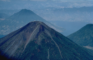 Volcán Atitlán, seen here from the SE with San Pedro volcano behind it and Tolimán volcano to its left, is a conical stratovolcano that rises to 3535 m south of Lake Atitlán (right). The historically active Atitlán is younger than Tolimán, although their activity overlaps. The northern side of the volcano is wooded to near the summit, whereas the upper 1000 m of the southern slopes, seen here, are unvegetated. Predominatley explosive eruptions have been recorded from Volcán Atitlán since the 15th century.
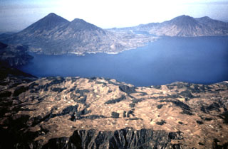 Three stratovolcanoes fill the southern half of Atitlán caldera in this view from the NE. Atitlán caldera formed during three major explosive eruptions from the Miocene to late Pleistocene. Atitlán volcano (far left) was constructed above the southern rim of the youngest caldera, Atitlán III, whose low southern rim is visible on the center horizon beyond narrow Santiago bay. Tolimán (right of Atitlán) and San Pedro (far right) overlie the rim of Atitlán II. The buried rim of Atitlán I lies below the shoreline of Tolimán.
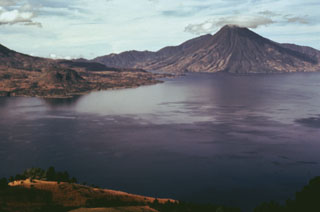 Volcán San Pedro (upper right) is the oldest of three stratovolcanoes constructed within Atitlán caldera. The furrowed slopes of the volcano contrast with the less eroded flanks of the both Atitlán and Tolimán volcanoes. Cerro de Oro, the small lava dome just beyond the shore of Lake Atitlán to the left, is a flank dome of Tolimán. Young lava flows from Tolimán descend into the lake and form part of its southern shore in this view from the west.
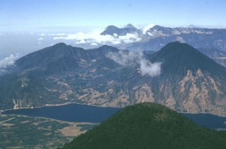 The rounded peak in the foreground is Tolimán volcano. The older post-caldera San Pedro volcano is across Santiago Bay to the right. In the distance are the peaks of Santo Tomás (left) and Santa María (right). Tajumulco volcano is the peak on the far-right horizon. The Guatemalan volcanic front rises more than 3,500 m above the hazy Pacific coastal plain to the upper left.
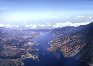 Santiago Bay in Lake Atitlán is the result of encroachment by the flanks of three post-caldera volcanoes into the lake. The narrow channel extends about 8 km to the low southern caldera wall and is about 1 km wide. To the right are the San Pedro flanks, the oldest of the post-caldera stratovolcanoes. Contrasting eruptive styles produced the irregular shoreline in the left foreground consisting of lava flows from Tolimán and the smoother shoreline to the right, formed by pyroclastic deposits from Atitlán.
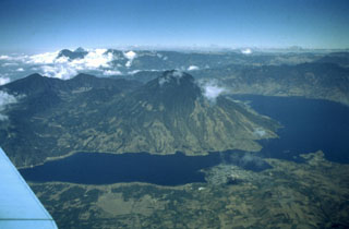 Volcán San Pedro (center) occupies the SW corner of the roughly 85,000-year-old Atitlán III caldera. San Pedro is seen here across narrow Santiago Bay from the lower slopes of Atitlán and Tolimán volcanoes. The 3020-m-high San Pedro has a shallow summit crater that is breached to the NW. The age of the most recent activity of San Pedro is unknown, although the volcano is more vegetated and erosionally modified than the twin volcanoes of Tolimán and Atitlán and is clearly the oldest of the three post-caldera volcanoes.
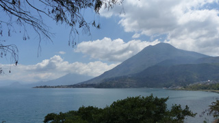 This 2018 view of Volcán San Pedro of Guatemala is from the W near San Juan La Laguna, with Volcán Tolimán volcano behind it. These cones along with the active Atitlán cone behind them have formed along the rim of the Atitlán III caldera, with the lake in the foreground filling the northern area.
 There are no samples for San Pedro in the Smithsonian's NMNH Department of Mineral Sciences Rock and Ore collection.
| Copernicus Browser | The Copernicus Browser replaced the Sentinel Hub Playground browser in 2023, to provide access to Earth observation archives from the Copernicus Data Space Ecosystem, the main distribution platform for data from the EU Copernicus missions. |
|
WOVOdat
Single Volcano View Temporal Evolution of Unrest Side by Side Volcanoes |
WOVOdat is a database of volcanic unrest; instrumentally and visually recorded changes in seismicity, ground deformation, gas emission, and other parameters from their normal baselines. It is sponsored by the World Organization of Volcano Observatories (WOVO) and presently hosted at the Earth Observatory of Singapore.
GVMID Data on Volcano Monitoring Infrastructure The Global Volcano Monitoring Infrastructure Database GVMID, is aimed at documenting and improving capabilities of volcano monitoring from the ground and space. GVMID should provide a snapshot and baseline view of the techniques and instrumentation that are in place at various volcanoes, which can be use by volcano observatories as reference to setup new monitoring system or improving networks at a specific volcano. These data will allow identification of what monitoring gaps exist, which can be then targeted by remote sensing infrastructure and future instrument deployments. |
| IRIS seismic stations/networks | Incorporated Research Institutions for Seismology (IRIS) Data Services map showing the location of seismic stations from all available networks (permanent or temporary) within a radius of 0.18° (about 20 km at mid-latitudes) from the given location of San Pedro. Users can customize a variety of filters and options in the left panel. Note that if there are no stations are known the map will default to show the entire world with a "No data matched request" error notice. |
| UNAVCO GPS/GNSS stations | Geodetic Data Services map from UNAVCO showing the location of GPS/GNSS stations from all available networks (permanent or temporary) within a radius of 20 km from the given location of San Pedro. Users can customize the data search based on station or network names, location, and time window. Requires Adobe Flash Player. |
| Large Eruptions of San Pedro | Information about large Quaternary eruptions (VEI >= 4) is cataloged in the Large Magnitude Explosive Volcanic Eruptions (LaMEVE) database of the Volcano Global Risk Identification and Analysis Project (VOGRIPA). |
| EarthChem | EarthChem develops and maintains databases, software, and services that support the preservation, discovery, access and analysis of geochemical data, and facilitate their integration with the broad array of other available earth science parameters. EarthChem is operated by a joint team of disciplinary scientists, data scientists, data managers and information technology developers who are part of the NSF-funded data facility Integrated Earth Data Applications (IEDA). IEDA is a collaborative effort of EarthChem and the Marine Geoscience Data System (MGDS). |

