Seismicity and fumarole characteristics from 2000 to 2011
Our BGVN reports discussing Mombacho volcano have discussed variable fumarolic gas emissions and characteristics of hot springs since 1980. Data collection from three distinct fumaroles became available by the Instituto Nicaragüense de Estudios Territoriales (INETER) starting in 1994 (BGVN 19:11). Since January 2000, the Geophysics Department of INETER has published "Sismos y Volcanes de Nicaragua," a monthly bulletin for volcanoes throughout Nicaragua. Status and seismicity reports for Mombacho appear as early as December 2000. Here we present a summary of field observations including local seismicity from 2000 to 2010, and thermal measurements from Mombacho's fumaroles from July 2001 to December 2011.
Local seismicity from 2000 through 2010. INETER reported a significant number of earthquake magnitudes and hypocenter locations in 2000 (table 1). A total of 14 events were registered and located during July-October. Few earthquakes were registered after 2000, with the largest magnitudes being ML 2.6-2.7. One seismic station with a radio repeater is located on Mombacho's flanks ~1.5 km to the NW of the summit.
Table 1. Located earthquakes recorded near Mombacho from 2000 through 2010. For each year, the table lists the number of located earthquakes, the range of their local magnitudes (ML), the range of their focal depths, and the average focal depths. Courtesy of INETER.
| Year | Earthquakes | ML | Range of focal depths (km) | Average focal depths (km) |
| 2000 | 14 | 2.1-2.9 | 0-6 | 2.9 |
| 2002 | 4 | 2.3-2.7 | 2-14 | 6 |
| 2004 | 2 | 2.5-2.6 | 4-18 | 11 |
| 2010 | 1 | 2.7 | 70 | 70 |
Fumarole temperature monitoring from 2001 to 2011. There are three well-established fumarole areas near the summit of Mombacho located above 800 m asl (figure 1 in BGVN 19:11). Fumarole temperatures were collected intermittently between July 2001 and December 2011 (table 2). Depending on surface conditions (local rockfalls often covered fumaroles), one to five different point sources were visited during this time period. Temperatures had a wide range and were frequently low; the lowest temperatures were recorded in November 2009 (81°C), March 2011 (61.5°C), and June 2011 (81°C). Temperatures greater than 125°C were rare; the highest measurements of 398°C were measured in August 2009, August 2010, and December 2011. INETER made numerous visits to Mombacho's fumarole fields from 2000 to 2011 however, it wasn't always possible to take measurements. Campaigns to fumarole sites were encumbered by dense vegetation; new trails needed to be cut for each visit, even with a time lapse as small as three months during the dry season. Temperatures were measured at fumaroles with a digital thermometer. INETER observed that landslides frequently covered fumarole sites and reported the extent of debris in their field reports: 19 August 2009, 14 May 2010, July 2010, 19 August 2010, 15 June 2011, 12 December 2011.
Table 2. Fumarole temperature data collected during campaigns to Mombacho sites from 2001 to 2011. Temperatures were measured with a handheld digital thermometer. Courtesy of INETER.
| Month | Temp. Range °C |
| Jul 2001 | 100-110 |
| Feb 2002 | 100-120 |
| Apr 2003 | 96.5-120.6 |
| Jul 2003 | 96.5-121.0 |
| Apr 2005 | 98.4-110.5 |
| Aug 2007 | 95.3-123 |
| Nov 2008 | 96.1-125 |
| Aug 2009 | 92-398 |
| Nov 2009 | 81-94 |
| Feb 2010 | 90-99 |
| May 2010 | 99-117 |
| Jul 2010 | 90-112 |
| Aug 2010 | 92-398 |
| Nov 2010 | 90-93 |
| Mar 2011 | 61.5 |
| Jun 2011 | 81-86 |
| Dec 2011 | 96-302 |
Field observations. Field visits from December 2000 to December 2011 by INETER consistently encountered the effects of landslides within Mombacho's southern crater. The steep walls, especially the E and W scarps, shed debris that collected within the crater. Evidence of large rockfalls was typically encountered after major rain events such as Hurricane Keith in September 2000 and a tropical storm in October 2010.
The southern crater is one of two dramatic collapse amphitheaters (figure 2). The collapse scars show up as high relief features in satellite imagery and topographic maps. At least three large-volume debris avalanche deposits have been attributed to Mombacho and resulted from catastrophic flank collapse (Shea and others, 2008). The long runout of the northern deposit reached Lake Nicaragua and formed the arcuate peninsula and cluster of islands, Isletas de Granada, ~11 km NE from Mombacho's summit (close-up photos and captions are available in the GVP Photo Archive).
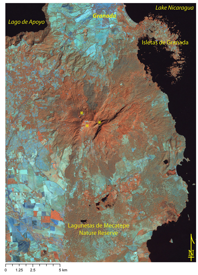 |
Figure 2. Satellite image centered on Mombacho using near-, mid-infrared, and infrared bands (Landsat bands 4,5,7). Recent rockfalls and water-poor soils appear cyan; brown-to-red areas indicate moist soils; water is black. Small ponds (irregular black shapes) are found within the Lagunetas de Mecatepe Reserve in an area mapped as debris avalanche deposits (Shea and others, 2008). Three yellow asterisks mark fumarole areas near the summit and local place names note major landmarks in the area including the city of Granada (N of the summit). The three circular features (~400 m diameter) located SW of the city of Granada, are the Granada Fissure Vents, sometimes called the La Joya alignment. Landsat acquired this ETM+ image on 27 January 2000 and it was processed by GVP (NASA Landsat Program, 2003). |
Several investigations into the debris avalanche deposits of Mombacho revealed new ideas about the likely factors that led to flank failure. The geologic setting of Mombacho includes the extensive pumice-rich ignimbrite deposits from Apoyo and Las Sierras and potentially lake sediments from Lake Nicaragua (figure 3). These relatively weak units that underlie Mombacho's edifice may have promoted gravitational spreading if the weight of the volcanic edifice caused deformation of the substratum. The near-vertical southern scarp exposes hydrothermally altered rock. This clay-rich material could have contributed to the weakening process that triggered the S-directed collapse. Deposits linked to the S-facing scarp have been mapped to the southernmost edge of the Lagunetas de Mecatepe Nature Reserve (~12 km from the summit).
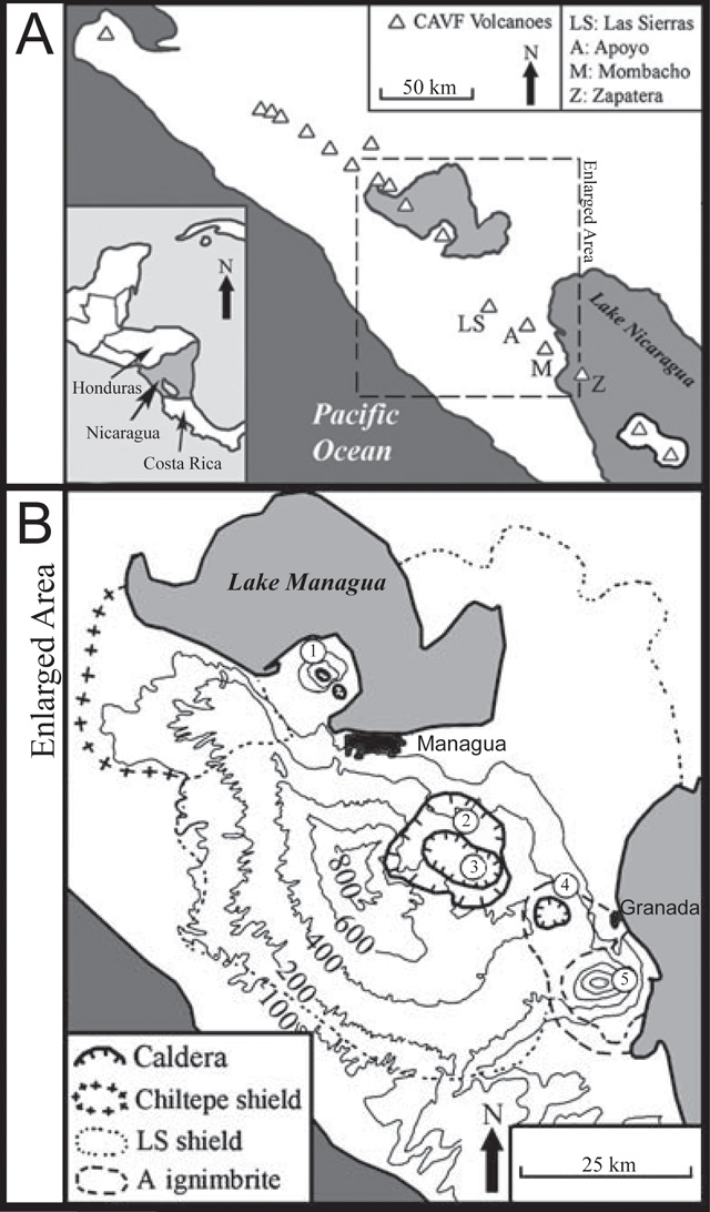 |
Figure 3. (A) The top figure is centered on the W coast of Nicaragua where major Quaternary volcanoes are aligned in the Central American Volcanic Front (CAVF). Mombacho (M) is located on the shore of Lake Nicaragua, within the enlarged area of this map, as well as other major sites: Las Sierras (LS), Apoyo (A), and Zapatera (Z). (B) Starting in the NW, the numbers correspond to major volcanic sites: 1 Chiltepe shield (Apoyeque and Jiloa Calderas), 2 Las Sierras caldera complex, 3 Masaya caldera complex, 4 Apoyo caldera, and 5 Mombacho volcano. This composite image is modified from Shea and others (2008) and van Wyk de Vries (1993). |
References. NASA Landsat Program (2003) Landsat ETM+ scene 7dt20000127, SLC-Off, USGS, Sioux Falls, Jan. 27, 2000.
Shea, T., van Wyk de Vries, B., and Pilato, M. (2008) Emplacement mechanisms of contrasting debris avalanches at Volcan Mombacho (Nicaragua), provided by structural and facies analysis. Bulletin of Volcanology, v. 70, p. 899-921.
van Wyk de Vries, B. (1993) Tectonics and magma evolution of Nicaraguan volcanic systems. [PhD thesis] Milton Keynes, The Open University, UK.
Information Contacts: Instituto Nicaragüense de Estudios Territoriales (INETER), Apartado Postal 2110, Managua, Nicaragua (URL: http://www.ineter.gob.ni/); Global Land Cover Facility (URL: http://http://www.glcf.umiacs.umd.edu/); Washington Volcanic Ash Advisory Center (VAAC), Satellite Analysis Branch (SAB), NOAA/NESDIS E/SP23, NOAA Science Center Room 401, 5200 Auth Rd, Camp Springs, MD 20746, USA (URL: http://www.ospo.noaa.gov/Products/atmosphere/vaac/).
The Global Volcanism Program has no Weekly Reports available for Mombacho.
Reports are organized chronologically and indexed below by Month/Year (Publication Volume:Number), and include a one-line summary. Click on the index link or scroll down to read the reports.
Small intermittent plume
In late 1980 a small, intermittent plume was visible, rising from the SE section of the summit.
Information Contacts: R. Stoiber, S. Williams, H.R. Naslund, L. Malinconico, M. Conrad, Dartmouth College; M. Carr, J. Walker, Rutgers Univ.; A. Creusot, Instituto Nicaraguense de Energía.
Four hot-springs located
"Paolo Pisani, a consultant to INE, reported finding four previously unknown low-temperature hot springs on the S side of Mombacho. These are not believed to be new, however."
Information Contacts: S. Williams, R. Stoiber, Dartmouth College; I. Menyailov, V. Shapar, IVP, Kamchatka; D. Fajardo B., INETER.
Noisy gas emissions from fumarole in collapse crater
A fumarole emitting gas with a loud noise has been seen in the southern collapse crater in 1986 and 1987.
Information Contacts: B. van Wyk de Vries, H. Rymer, and G. Brown, Open Univ; P. Hradecky and H. Taleno, INETER.
Continued gas emission
"The fumarole in the S collapse crater continued to emit gas."
Information Contacts: B. van Wyk de Vries, O. Castellón, A. Murales, and V. Tenorio, INETER.
Venting continues from fumarole in south crater; two other fumarole areas located
The fumarole that has been active since at least 1986 continued to vent vapor in November and December 1993. A strong sulfur odor was detected even when the wind was blowing towards the fumarole. This observation led to the discovery of two other previously unreported fumarole fields (figure 1). Vapor was seen rising from both, but they were not approached closely; neither appeared to be a new feature.
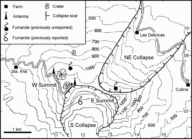 |
Figure 1. Map of the Mombacho summit area, showing locations of reported and previously unreported fumarole areas. Courtesy of B. van Wyk de Vries and P. Hernandez. |
Information Contacts: B. van Wyk de Vries, Open Univ; Pedro Hernandez, INETER.
Seismicity and fumarole characteristics from 2000 to 2011
Our BGVN reports discussing Mombacho volcano have discussed variable fumarolic gas emissions and characteristics of hot springs since 1980. Data collection from three distinct fumaroles became available by the Instituto Nicaragüense de Estudios Territoriales (INETER) starting in 1994 (BGVN 19:11). Since January 2000, the Geophysics Department of INETER has published "Sismos y Volcanes de Nicaragua," a monthly bulletin for volcanoes throughout Nicaragua. Status and seismicity reports for Mombacho appear as early as December 2000. Here we present a summary of field observations including local seismicity from 2000 to 2010, and thermal measurements from Mombacho's fumaroles from July 2001 to December 2011.
Local seismicity from 2000 through 2010. INETER reported a significant number of earthquake magnitudes and hypocenter locations in 2000 (table 1). A total of 14 events were registered and located during July-October. Few earthquakes were registered after 2000, with the largest magnitudes being ML 2.6-2.7. One seismic station with a radio repeater is located on Mombacho's flanks ~1.5 km to the NW of the summit.
Table 1. Located earthquakes recorded near Mombacho from 2000 through 2010. For each year, the table lists the number of located earthquakes, the range of their local magnitudes (ML), the range of their focal depths, and the average focal depths. Courtesy of INETER.
| Year | Earthquakes | ML | Range of focal depths (km) | Average focal depths (km) |
| 2000 | 14 | 2.1-2.9 | 0-6 | 2.9 |
| 2002 | 4 | 2.3-2.7 | 2-14 | 6 |
| 2004 | 2 | 2.5-2.6 | 4-18 | 11 |
| 2010 | 1 | 2.7 | 70 | 70 |
Fumarole temperature monitoring from 2001 to 2011. There are three well-established fumarole areas near the summit of Mombacho located above 800 m asl (figure 1 in BGVN 19:11). Fumarole temperatures were collected intermittently between July 2001 and December 2011 (table 2). Depending on surface conditions (local rockfalls often covered fumaroles), one to five different point sources were visited during this time period. Temperatures had a wide range and were frequently low; the lowest temperatures were recorded in November 2009 (81°C), March 2011 (61.5°C), and June 2011 (81°C). Temperatures greater than 125°C were rare; the highest measurements of 398°C were measured in August 2009, August 2010, and December 2011. INETER made numerous visits to Mombacho's fumarole fields from 2000 to 2011 however, it wasn't always possible to take measurements. Campaigns to fumarole sites were encumbered by dense vegetation; new trails needed to be cut for each visit, even with a time lapse as small as three months during the dry season. Temperatures were measured at fumaroles with a digital thermometer. INETER observed that landslides frequently covered fumarole sites and reported the extent of debris in their field reports: 19 August 2009, 14 May 2010, July 2010, 19 August 2010, 15 June 2011, 12 December 2011.
Table 2. Fumarole temperature data collected during campaigns to Mombacho sites from 2001 to 2011. Temperatures were measured with a handheld digital thermometer. Courtesy of INETER.
| Month | Temp. Range °C |
| Jul 2001 | 100-110 |
| Feb 2002 | 100-120 |
| Apr 2003 | 96.5-120.6 |
| Jul 2003 | 96.5-121.0 |
| Apr 2005 | 98.4-110.5 |
| Aug 2007 | 95.3-123 |
| Nov 2008 | 96.1-125 |
| Aug 2009 | 92-398 |
| Nov 2009 | 81-94 |
| Feb 2010 | 90-99 |
| May 2010 | 99-117 |
| Jul 2010 | 90-112 |
| Aug 2010 | 92-398 |
| Nov 2010 | 90-93 |
| Mar 2011 | 61.5 |
| Jun 2011 | 81-86 |
| Dec 2011 | 96-302 |
Field observations. Field visits from December 2000 to December 2011 by INETER consistently encountered the effects of landslides within Mombacho's southern crater. The steep walls, especially the E and W scarps, shed debris that collected within the crater. Evidence of large rockfalls was typically encountered after major rain events such as Hurricane Keith in September 2000 and a tropical storm in October 2010.
The southern crater is one of two dramatic collapse amphitheaters (figure 2). The collapse scars show up as high relief features in satellite imagery and topographic maps. At least three large-volume debris avalanche deposits have been attributed to Mombacho and resulted from catastrophic flank collapse (Shea and others, 2008). The long runout of the northern deposit reached Lake Nicaragua and formed the arcuate peninsula and cluster of islands, Isletas de Granada, ~11 km NE from Mombacho's summit (close-up photos and captions are available in the GVP Photo Archive).
|
Figure 2. Satellite image centered on Mombacho using near-, mid-infrared, and infrared bands (Landsat bands 4,5,7). Recent rockfalls and water-poor soils appear cyan; brown-to-red areas indicate moist soils; water is black. Small ponds (irregular black shapes) are found within the Lagunetas de Mecatepe Reserve in an area mapped as debris avalanche deposits (Shea and others, 2008). Three yellow asterisks mark fumarole areas near the summit and local place names note major landmarks in the area including the city of Granada (N of the summit). The three circular features (~400 m diameter) located SW of the city of Granada, are the Granada Fissure Vents, sometimes called the La Joya alignment. Landsat acquired this ETM+ image on 27 January 2000 and it was processed by GVP (NASA Landsat Program, 2003). |
Several investigations into the debris avalanche deposits of Mombacho revealed new ideas about the likely factors that led to flank failure. The geologic setting of Mombacho includes the extensive pumice-rich ignimbrite deposits from Apoyo and Las Sierras and potentially lake sediments from Lake Nicaragua (figure 3). These relatively weak units that underlie Mombacho's edifice may have promoted gravitational spreading if the weight of the volcanic edifice caused deformation of the substratum. The near-vertical southern scarp exposes hydrothermally altered rock. This clay-rich material could have contributed to the weakening process that triggered the S-directed collapse. Deposits linked to the S-facing scarp have been mapped to the southernmost edge of the Lagunetas de Mecatepe Nature Reserve (~12 km from the summit).
|
Figure 3. (A) The top figure is centered on the W coast of Nicaragua where major Quaternary volcanoes are aligned in the Central American Volcanic Front (CAVF). Mombacho (M) is located on the shore of Lake Nicaragua, within the enlarged area of this map, as well as other major sites: Las Sierras (LS), Apoyo (A), and Zapatera (Z). (B) Starting in the NW, the numbers correspond to major volcanic sites: 1 Chiltepe shield (Apoyeque and Jiloa Calderas), 2 Las Sierras caldera complex, 3 Masaya caldera complex, 4 Apoyo caldera, and 5 Mombacho volcano. This composite image is modified from Shea and others (2008) and van Wyk de Vries (1993). |
References. NASA Landsat Program (2003) Landsat ETM+ scene 7dt20000127, SLC-Off, USGS, Sioux Falls, Jan. 27, 2000.
Shea, T., van Wyk de Vries, B., and Pilato, M. (2008) Emplacement mechanisms of contrasting debris avalanches at Volcan Mombacho (Nicaragua), provided by structural and facies analysis. Bulletin of Volcanology, v. 70, p. 899-921.
van Wyk de Vries, B. (1993) Tectonics and magma evolution of Nicaraguan volcanic systems. [PhD thesis] Milton Keynes, The Open University, UK.
Information Contacts: Instituto Nicaragüense de Estudios Territoriales (INETER), Apartado Postal 2110, Managua, Nicaragua (URL: http://www.ineter.gob.ni/); Global Land Cover Facility (URL: http://http://www.glcf.umiacs.umd.edu/); Washington Volcanic Ash Advisory Center (VAAC), Satellite Analysis Branch (SAB), NOAA/NESDIS E/SP23, NOAA Science Center Room 401, 5200 Auth Rd, Camp Springs, MD 20746, USA (URL: http://www.ospo.noaa.gov/Products/atmosphere/vaac/).
This compilation of synonyms and subsidiary features may not be comprehensive. Features are organized into four major categories: Cones, Craters, Domes, and Thermal Features. Synonyms of features appear indented below the primary name. In some cases additional feature type, elevation, or location details are provided.
Synonyms |
||||
| Mambacho | ||||
Cones |
||||
| Feature Name | Feature Type | Elevation | Latitude | Longitude |
| Posintepe, Cerro | Cone | |||
|
|
||||||||||||||||||||||||
There is data available for 0 confirmed Holocene eruptive periods.
[ 1850 ] Discredited Eruption
The report of the formation of the the parasitic cone Pilas on the N flank is very doubtful, for it is reported only by Crawford, who probably confused it with the 1850 formation of Cerro Negro on the north side of Las Pilas volcano (CAVW).
[ 1570 ] Uncertain Eruption
| Episode 1 | Eruption Episode | ||||||||||||||||||||||||||||||||||||||||
|---|---|---|---|---|---|---|---|---|---|---|---|---|---|---|---|---|---|---|---|---|---|---|---|---|---|---|---|---|---|---|---|---|---|---|---|---|---|---|---|---|
| 1570 - Unknown | Evidence from Unknown | |||||||||||||||||||||||||||||||||||||||
|
List of 6 Events for Episode 1
| ||||||||||||||||||||||||||||||||||||||||
There is no Deformation History data available for Mombacho.
There is no Emissions History data available for Mombacho.
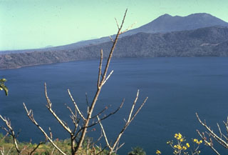 The 7-km-wide, lake-filled Apoyo caldera, seen here from the NW with Mombacho volcano in the background, is a large silicic volcanic center immediately SE of Masaya caldera. An early shield volcano constructed of basaltic-to-andesitic lava flows and small rhyodacitic lava domes collapsed following two major dacitic explosive eruptions about 23,000 years ago. Post-caldera ring-fracture eruptions formed the Granada cinder cones and La Joya collapse craters along fracture systems to the east of the caldera. The age of the latest activity is not known.
 Mombacho is a stratovolcano on the shores of Lake Nicaragua that has undergone edifice collapse on several occasions. The NE-flank scarp was the source of a large debris avalanche that produced an arcuate peninsula and the Las Isletas chain of islands in Lake Nicaragua. The only reported historical activity was in 1570, when a debris avalanche destroyed a village on the S side of the volcano.
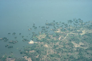 Las Isletas, a group of islands that were created by a large Holocene debris avalanche from Mombacho that swept into Lake Nicaragua. The avalanche traveled at least 12 km. The hummocky debris created an arcuate peninsula that extends into the lake as well as hundreds of small islands. This morphology is common where debris avalanches enter shallow bodies of water.
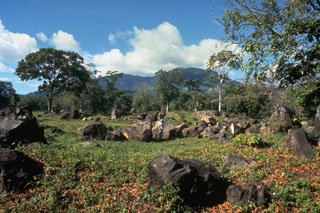 These angular boulders are part of a debris-avalanche deposit that originated from the south side of Mombacho volcano (seen in the background), most likely in 1570 CE. The avalanche traveled 13 km from Mombacho, and destroyed a village, killing 400 people.
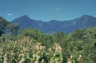 The south side of Mombacho contains a horseshoe-shaped crater that was the source of a large debris avalanche in 1570 CE that swept over a village south of the volcano, killing 400 people. The avalanche traveled 13 km S; contemporary accounts note that if it had occurred to the north, it would have reached the city of Granada. Contemporary accounts indicate that the volcano "exploded," but eruptive activity associated with the collapse has not been documented.
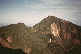 The south side of Mombacho volcano is cut by a large horseshoe-shaped depression that left two major summit peaks. Recent landslips scar the face of the higher easternmost peak. The depression was formed during collapse of the volcano, which produced a large debris avalanche that traveled to the south. The 2-km-wide depression merges with a scarp from a NE-flank collapse, which lies on the other side of the notch in the center of the photo.
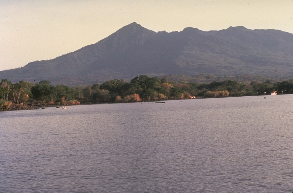
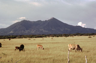 Volcán Mombacho rises above cattle ranches on the plain of Nandaime, south of the volcano. The volcano's irregular summit with two major peaks reaching 1222 and 1333 m resulted from collapse of the top of the volcano, which left the horseshoe-shaped depression in the center of the photo. Mombacho is the centerpiece of the Mombacho Volcano Reserve, whose forested terrain contains exotic orchids, birds and primates.
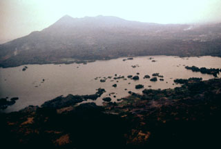 Mombacho volcano in the background collapsed during the late Pleistocene, producing a debris avalanche that swept into Lake Nicaragua, deposting debris that accumulated to form the Aseses Peninsula in the foreground. The surface of the avalanche deposit lies below the lake surface immediately offshore of the mainland, creating the Bay of Aseses in the middle of the photo. Portions of the deposit rise above the lake surface, forming hundreds of small islands.
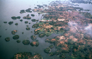 Las Isletas, or Isletas de Granada, are a cluster of about 500 small islands flanking the Aseses Peninsula extending into Lake Nicaragua. They were formed when the NE flank of Mombacho volcano collapsed, producing a debris avalanche that swept into the lake. A road leads down the peninsula to the settlement of El Diamante seen above the center of the photo. The peninsula is a resort area visited frequently from the nearby city of Granada. Many of the islands host vacation residences.
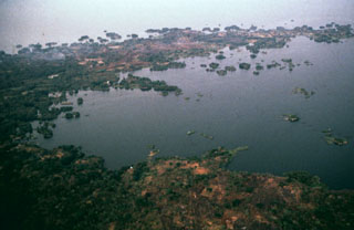 The arcuate Aseses Peninsula extending 5 km into Lake Nicaragua was formed when the NE flank of Mombacho volcano collapsed producing a highly mobile debris avalanche that swept into the lake. Flanking the peninsula are hundreds of small islands, known as Las Isletas, or Isletas de Granada. These are the tops of hummocky terrain formed of debris from the avalanche, which traveled as far as 12 km from the volcano.
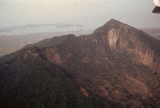 An aerial view of Mombacho from the SW shows the higher eastern summit of the twin-peaked volcano at the right. In the foreground is the southernmost of two large collapse scarps that cut the edifice. The other scarp, out of view on the NE flank beyond the ridge below the summit, was the source of a large debris avalanche that swept into Lake Nicaragua, forming the Aseses Peninsula and Las Isletas at the upper left.
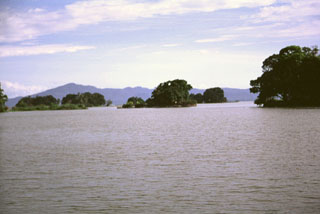 These small forested islands are hummocks of a large debris avalanche from Mombacho volcano that swept into Lake Nicaragua. The horizon is formed by Isla Zapatera volcano, SE of Mombacho.
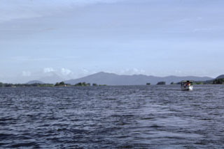 A small boat plies the waters of Ensenada de Aseses, with Zapatera Island forming the horizon to the SE. In the middle distance are the small island hummocks of Las Isletas, formed by a debris avalanche from Mombacho volcano, out of view to the right. The conical peak on the distant left horizon is Concepción volcano; the low, rounded peak to its left is Cerro las Banderas, a pyroclastic cone on the NE tip of Zapatera Island.
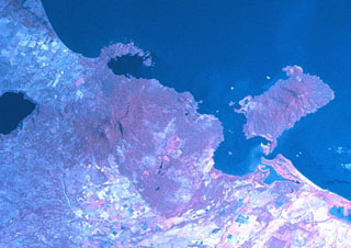 Two major scarps cutting Mombacho volcano (left-center) were the sources of major debris avalanches. The arcuate peninsula and island chain extending into Lake Nicaragua (known as Las Isletas or Isletas de Granada) was produced by collapse of Mombacho to the NE. The island at the right is Zapatera, a small shield volcano and maar complex. The lake at the far left fills late-Pleistocene Apoyo caldera, and the roughly N-S-trending Granada cinder cone alignment lies NNW of Mombacho and east of Lake Apoyo in this NASA Space Shuttle image (with north to the upper left).
 Two major flank-collapse scarps on the NE and SW sides of Mombacho are visible in this March 2019 Planet Labs satellite image monthly mosaic (N is at the top; this image is approximately 25 km across). The islands to the NE are part of the 56.8 km2 Las Isletas debris avalanche deposit; the 49.5 km2 El Crater debris avalanche deposit is to the S. The La Danta debris avalanche deposit is between the two on the SE flank and surrounding area.
The maps shown below have been scanned from the GVP map archives and include the volcano on this page. Clicking on the small images will load the full 300 dpi map. Very small-scale maps (such as world maps) are not included. The maps database originated over 30 years ago, but was only recently updated and connected to our main database. We welcome users to tell us if they see incorrect information or other problems with the maps; please use the Contact GVP link at the bottom of the page to send us email.
There are no samples for Mombacho in the Smithsonian's NMNH Department of Mineral Sciences Rock and Ore collection.
| Copernicus Browser | The Copernicus Browser replaced the Sentinel Hub Playground browser in 2023, to provide access to Earth observation archives from the Copernicus Data Space Ecosystem, the main distribution platform for data from the EU Copernicus missions. |
| MIROVA | Middle InfraRed Observation of Volcanic Activity (MIROVA) is a near real time volcanic hot-spot detection system based on the analysis of MODIS (Moderate Resolution Imaging Spectroradiometer) data. In particular, MIROVA uses the Middle InfraRed Radiation (MIR), measured over target volcanoes, in order to detect, locate and measure the heat radiation sourced from volcanic activity. |
| MODVOLC Thermal Alerts | Using infrared satellite Moderate Resolution Imaging Spectroradiometer (MODIS) data, scientists at the Hawai'i Institute of Geophysics and Planetology, University of Hawai'i, developed an automated system called MODVOLC to map thermal hot-spots in near real time. For each MODIS image, the algorithm automatically scans each 1 km pixel within it to check for high-temperature hot-spots. When one is found the date, time, location, and intensity are recorded. MODIS looks at every square km of the Earth every 48 hours, once during the day and once during the night, and the presence of two MODIS sensors in space allows at least four hot-spot observations every two days. Each day updated global maps are compiled to display the locations of all hot spots detected in the previous 24 hours. There is a drop-down list with volcano names which allow users to 'zoom-in' and examine the distribution of hot-spots at a variety of spatial scales. |
|
WOVOdat
Single Volcano View Temporal Evolution of Unrest Side by Side Volcanoes |
WOVOdat is a database of volcanic unrest; instrumentally and visually recorded changes in seismicity, ground deformation, gas emission, and other parameters from their normal baselines. It is sponsored by the World Organization of Volcano Observatories (WOVO) and presently hosted at the Earth Observatory of Singapore.
GVMID Data on Volcano Monitoring Infrastructure The Global Volcano Monitoring Infrastructure Database GVMID, is aimed at documenting and improving capabilities of volcano monitoring from the ground and space. GVMID should provide a snapshot and baseline view of the techniques and instrumentation that are in place at various volcanoes, which can be use by volcano observatories as reference to setup new monitoring system or improving networks at a specific volcano. These data will allow identification of what monitoring gaps exist, which can be then targeted by remote sensing infrastructure and future instrument deployments. |
| Volcanic Hazard Maps | The IAVCEI Commission on Volcanic Hazards and Risk has a Volcanic Hazard Maps database designed to serve as a resource for hazard mappers (or other interested parties) to explore how common issues in hazard map development have been addressed at different volcanoes, in different countries, for different hazards, and for different intended audiences. In addition to the comprehensive, searchable Volcanic Hazard Maps Database, this website contains information about diversity of volcanic hazard maps, illustrated using examples from the database. This site is for educational purposes related to volcanic hazard maps. Hazard maps found on this website should not be used for emergency purposes. For the most recent, official hazard map for a particular volcano, please seek out the proper institutional authorities on the matter. |
| IRIS seismic stations/networks | Incorporated Research Institutions for Seismology (IRIS) Data Services map showing the location of seismic stations from all available networks (permanent or temporary) within a radius of 0.18° (about 20 km at mid-latitudes) from the given location of Mombacho. Users can customize a variety of filters and options in the left panel. Note that if there are no stations are known the map will default to show the entire world with a "No data matched request" error notice. |
| UNAVCO GPS/GNSS stations | Geodetic Data Services map from UNAVCO showing the location of GPS/GNSS stations from all available networks (permanent or temporary) within a radius of 20 km from the given location of Mombacho. Users can customize the data search based on station or network names, location, and time window. Requires Adobe Flash Player. |
| DECADE Data | The DECADE portal, still in the developmental stage, serves as an example of the proposed interoperability between The Smithsonian Institution's Global Volcanism Program, the Mapping Gas Emissions (MaGa) Database, and the EarthChem Geochemical Portal. The Deep Earth Carbon Degassing (DECADE) initiative seeks to use new and established technologies to determine accurate global fluxes of volcanic CO2 to the atmosphere, but installing CO2 monitoring networks on 20 of the world's 150 most actively degassing volcanoes. The group uses related laboratory-based studies (direct gas sampling and analysis, melt inclusions) to provide new data for direct degassing of deep earth carbon to the atmosphere. |
| Large Eruptions of Mombacho | Information about large Quaternary eruptions (VEI >= 4) is cataloged in the Large Magnitude Explosive Volcanic Eruptions (LaMEVE) database of the Volcano Global Risk Identification and Analysis Project (VOGRIPA). |
| EarthChem | EarthChem develops and maintains databases, software, and services that support the preservation, discovery, access and analysis of geochemical data, and facilitate their integration with the broad array of other available earth science parameters. EarthChem is operated by a joint team of disciplinary scientists, data scientists, data managers and information technology developers who are part of the NSF-funded data facility Integrated Earth Data Applications (IEDA). IEDA is a collaborative effort of EarthChem and the Marine Geoscience Data System (MGDS). |

