

Eruption is slowly abating; intermittent explosions and decreased lava production
Card 1615 (24 April 1973) Eruption is slowly abating; intermittent explosions and decreased lava production
After three months of continuous activity, S. Thorarinsson reported on 21 April that the Heimaey eruption is slowly abating. The explosive activity is now intermittent and the estimated lava production is less than 5 m3 per second. The area of the lava flow is 2.1 km2, and the average thickness is about 70 m. The height of the volcano is approximately 220 m.
Information Contacts: Sigurdur Thorarinsson, Science Institute, University of Iceland.
The Global Volcanism Program has no Weekly Reports available for Vestmannaeyjar.
Reports are organized chronologically and indexed below by Month/Year (Publication Volume:Number), and include a one-line summary. Click on the index link or scroll down to read the reports.
Vigorous late-January fissure eruption forces evacuations
Card 1545 (23 January 1973) Fissure eruption emits lava flow; evacuation of about 5,000 people
The following cable was received . . . on 23 January 1973. "An intense volcanic eruption on the vast side of the mountain Helgafell, Vestmannaeyjar, Iceland, was observed at 0155 GMT on 23 January 1973. Lava is flowing eastwards from a fissure some 1,500 m long. Approximate location: Latitude 63°26' N, Longitude 20°16' W. The eruption was preceded by a swarm of small earthquakes on 22 and 23 January. The largest earthquake was 2.6 on the Richter scale. The nearby town of Vestmannaeyjar, inhabited by about 5,000 people, has been mostly evacuated to the mainland. No casualties."
Card 1547 (24 January 1973) Lava fountains at start of eruption preceded by earthquake swarm
The following information was obtained through telephone and telegraphic contact with the Icelandic Meteorological Office. "The Helgafell eruption continues. The fissure is 1.6 km in length and on the eastern slope of the volcano. At first, mostly lava fountains characterized the eruption, but now there is a great quantity of smoke. The fissure extends in a straight line and trends in a direction NNE-SSW. It extends into the sea at both ends, and small islands seem to be forming near the coast under the sea as lava continues to extrude from the fissure. Fire and pyroclastic clouds are visible, and the lava fountains reached 375 feet in height.
"The eruption was preceded by a swarm of earthquakes beginning at 2000 GMT on 21 January with origin within 10 km from the fissure. The main swarm recorded at a seismic station some 60 km away was between 2200 GMT on the 21st and 0600 GMT on the 22nd. At least 200 earthquakes, recorded mainly between 0100 and 0300 on the 22nd. A few earthquakes were then recorded until 1100 GMT on the 22nd but after that no earthquakes until 2330 GMT that evening. From 2230 to 0134 GMT on the 23rd, seven earthquakes were recorded. During this period a few earthquakes were felt in Vestmannaeyjar. The largest earthquakes were magnitude about 2.7 Richter on the 22nd at 0416 GMT and 23rd at 0134 GMT."
Card 1549 (26 January 1973) Eruption clouds above 15,000 feet; lava continues to enter the harbor
The following cables were received . . . on 26 January.
[The following was received from the Icelandic Meteorological Office.] "Height of Vestmannaeyjar eruption cloud was estimated from aircraft to be as follows: 15,000-16,000 feet at 1644 GMT on 24 January; 18,000-20,000 feet at 1025 GMT on 25 January; 22,000 feet at 1305 GMT on 25 January."
[The following was received from the Icelandic Marine Research Institute.] "Ecological changes in sea strictly local and will not have any economic effects. Land vegetation badly damaged by lava and airborne material at least in the neighborhood of the eruption. Effect on other systems on land, such as vegetation further away and bird populations, still known. Lava continues to pour into the harbor and water temperatures have reached 111°F. AT least five houses were destroyed by fire started by the lava. The 1.6 km rift has become partly filled with lava. One main crater and several smaller craters are expelling fire, smoke, and lava."
Card 1551 (26 January 1973) Fountaining concentrated in N sector of fissure zone; 120-m-high cone built
The following cable was received . . . on 26 January. "Flight over Heimaey at 2200 local time on 26 January revealed activity concentrated in northern sector of fissure zone. Strongest fountaining is from new cone at southern terminus of this sector now built to about 120 m above sea level. Fountaining rises an additional 150 m above cone. About six other smaller fountains at about 100 m intervals to north along fissure. Lava flowing mainly northwards forming bench which now extends for at least 500 m out from coast. Six houses have now been set alight in Kaupstadur by hot tephra."
Card 1552 (29 January 1973) About 15 million cubic meters of lava produced in first 40 hours of eruption
The following cable was received . . . on 27 January. "27 January, 1100 GMT. When Heimaey eruption had lasted 40 hours, the lava produced estimated 15 million m3, average production 100 m3 per second. Length of fissure 23 January, 1500 hours, 1.8 km. 26 January it had extended to nearly 3 km but eruption concentrated to about 400 m stretch near middle building up tephra cone eruption about 50 m. Column reached 9 km 25 January. Night before 26th Heimaey town was covered with tephra layer 10 cm harbor to 2 m thick near craters. Last night thickness decreased considerably. Direction fissure NNE/SSW 27 January 1700 hours. Measured crater first time today. Relative height about 100 m eruption somewhat diminishing today."
Card 1556 (31 January 1973) Thermal and visual satellite imagery shows eruption on 25 January
The NOAA-2 satellite made a pass over the Helgafell eruption at 1040 UT on 24 January 1973. The instrument used was a very high resolution radiometer (DHRR). The DHRR has two spectral centers—two central bands—one in the thermal infrared at 10.5 and 12.5 µm, and the other one at .6 and .7 µm. On the infrared image the eruption showed up in both the thermal and the visible as 8 resolution elements. The eruption cloud showed up trending approximately E-W, going in an easterly direction from the source of the cloud in the west. The eruption cloud was 60 km long and its maximum width was 12 km.
Iceland, which was dark at the time, was not picked up as a visible image. However, the satellite did observe the eruption cloud, which was illuminated by the sun at the same time on 25 January at 1040 UT. It observed essentially the same pattern as the thermal.
What is most interesting about the visible image is that you can see the fissure aglow with the molten lava. The volcanic eruption on Heimaey shows up as a very thin, faint line which is oriented N to NE. The resolution of the DHRR system in both visible and infrared is 0.8 km. It is a fairly extraordinary series of images.
Information Contacts:
Card 1545 (23 January 1973) S. Thorarinsson, Science Institute, University of Iceland; Flosi Hrafn Sigurdsson, Iceland Meteorological Office.
Card 1547 (24 January 1973) Flosi Hrafn Sigurdsson, Iceland Meteorological Office.
Card 1549 (26 January 1973) F.H. Sigurdsson, Icelandic Meteorological Office; Adelsteinn Sigurdsson, Icelandic Marine Research Institute.
Card 1551 (26 January 1973) Sigurdur Thorarinsson, Science Institute, University of Iceland; Paul Mohr, Smithsonian Astrophysical Observatory.
Card 1552 (29 January 1973) Sigurdur Thorarinsson, Science Institute, University of Iceland.
Card 1556 (31 January 1973) Paul McClain and Donald Wiesnet, NOAA/NESS; Richard Williams, U.S. Geological Survey.
Abundant lava flows during mid-February almost close the harbor
Card 1567 (13 February 1973) Lava flow area 3 km2 as of 13 February
The following information was received by cable on 13 February 1973. "On 13 February the eruption was still continuing. The area of the lava flow is now 3 km2, and the volume is about 110 million m3. The composition is gradually changing from hawaiite to more normal basalt. The harbor is now nearly closed due to the lava flow, but the amount of tephra fall is relatively small. The height of the new cone (tentatively called 'Kirkjufell') is 160 m and the estimated rate of flow is now 60 m3 per second [on 8 February]."
Card 1569 (23 February 1973) Crater wall subsidence; lava flowing E and NE
A new development on Heimaey on 19-20 February originally appeared to increase the threat to the town of Vestmannaeyjar. According to a cable received on 23 February, however, "the development in Vestmannaeyjar on 19-20 February did not increase the threat to the town. The part of the crater wall facing the town slowly 'glided out' and subsided about 120 m distant. The lava now flows east and northeast. The greatest danger if the eruption lasts for a long time is still the lava flow. The lava is now thin-flowing and the latest temperature was 1,090°C, as measured by the physicist, Dr. Sigurgeirsson."
Information Contacts:
Card 1567 (13 February 1973) Sigurdur Thorarinsson, Science Institute, University of Iceland.
Card 1569 (23 February 1973) Sigurdur Thorarinsson, Science Institute, University of Iceland.
Intermittent explosions and tephra-fall; lava flows cover 80 houses
Card 1582 (12 March 1973) Tephra being blown out to sea; lava flow nearly closing harbor entrance
Helgafell status as of 9 March 1973: The eruption is now considered moderate. Tephra is still falling, but is rather minor compared to the fall during the early part of the eruption. It is being blown out to sea. The principal characteristics of the eruption are the lava flow and the intermittent explosions. The lava is flowing out to sea, and is 30 m away from closing off the entrance to the harbor. Gases seeping in to the cellars of the homes have become a serious problem. These gases are CO, CO2, and SO2.
Card 1591 (26 March 1973) Lava has now covered at least 80 houses
S. Thorarinsson reported by cable on 24 March that there has been no increase in the activity of the Heimaey volcanic eruption. The lava production has been approximately 10 m3/s since 17 March. Lava has covered at least 80 houses in the eastern part of the town, including 23 on the night of 22-23 March, but no more since then. The lava is somewhat more thin-flowing than before.
Information Contacts:
Card 1582 (12 March 1973) Sigurdur Thorarinsson, Science Institute, University of Iceland; Mr. Helgason, Icelandic Embassy, Washington DC, USA.
Card 1591 (26 March 1973) Sigurdur Thorarinsson, Science Institute, University of Iceland.
Eruption is slowly abating; intermittent explosions and decreased lava production
Card 1615 (24 April 1973) Eruption is slowly abating; intermittent explosions and decreased lava production
After three months of continuous activity, S. Thorarinsson reported on 21 April that the Heimaey eruption is slowly abating. The explosive activity is now intermittent and the estimated lava production is less than 5 m3 per second. The area of the lava flow is 2.1 km2, and the average thickness is about 70 m. The height of the volcano is approximately 220 m.
Information Contacts: Sigurdur Thorarinsson, Science Institute, University of Iceland.
|
|
||||||||||||||||||||||||||||
There is data available for 10 confirmed Holocene eruptive periods.
1973 Jan 23 - 1973 Jun 28 Confirmed Eruption (Explosive / Effusive) VEI: 3
| Episode 1 | Eruption (Explosive / Effusive) | Heimaey (Eldfell) | ||||||||||||||||||||||||||||||||||||||||||||||||||||||||||||||||||||||||||
|---|---|---|---|---|---|---|---|---|---|---|---|---|---|---|---|---|---|---|---|---|---|---|---|---|---|---|---|---|---|---|---|---|---|---|---|---|---|---|---|---|---|---|---|---|---|---|---|---|---|---|---|---|---|---|---|---|---|---|---|---|---|---|---|---|---|---|---|---|---|---|---|---|---|---|---|
| 1973 Jan 23 - 1973 Jun 28 | Evidence from Observations: Reported | ||||||||||||||||||||||||||||||||||||||||||||||||||||||||||||||||||||||||||
|
List of 13 Events for Episode 1 at Heimaey (Eldfell)
|
|||||||||||||||||||||||||||||||||||||||||||||||||||||||||||||||||||||||||||
1963 Nov 8 - 1967 Jun 5 Confirmed Eruption (Explosive / Effusive) VEI: 3
| Episode 1 | Eruption (Explosive / Effusive) | Surtsey | ||||||||||||||||||||||||||||||||||||||||||||||||||||||||||||||||||||||||||
|---|---|---|---|---|---|---|---|---|---|---|---|---|---|---|---|---|---|---|---|---|---|---|---|---|---|---|---|---|---|---|---|---|---|---|---|---|---|---|---|---|---|---|---|---|---|---|---|---|---|---|---|---|---|---|---|---|---|---|---|---|---|---|---|---|---|---|---|---|---|---|---|---|---|---|---|
| 1963 Nov 8 - 1967 Jun 5 | Evidence from Observations: Reported | ||||||||||||||||||||||||||||||||||||||||||||||||||||||||||||||||||||||||||
|
List of 13 Events for Episode 1 at Surtsey
|
|||||||||||||||||||||||||||||||||||||||||||||||||||||||||||||||||||||||||||
1896 Sep Confirmed Eruption (Explosive / Effusive)
| Episode 1 | Eruption (Explosive / Effusive) | South or SE of Hellisey | ||||||||||||||
|---|---|---|---|---|---|---|---|---|---|---|---|---|---|---|---|
| 1896 Sep - Unknown | Evidence from Observations: Reported | ||||||||||||||
|
List of 1 Events for Episode 1 at South or SE of Hellisey
|
|||||||||||||||
1637 Oct - 1638 Feb 28 ± 60 days Confirmed Eruption (Explosive / Effusive)
| Episode 1 | Eruption (Explosive / Effusive) | SW of Heimaey ? | |||||||||||||||||||
|---|---|---|---|---|---|---|---|---|---|---|---|---|---|---|---|---|---|---|---|---|
| 1637 Oct - 1638 Feb 28 ± 60 days | Evidence from Observations: Reported | |||||||||||||||||||
|
List of 2 Events for Episode 1 at SW of Heimaey ?
|
||||||||||||||||||||
3950 BCE ± 300 years Confirmed Eruption (Explosive / Effusive)
| Episode 1 | Eruption (Explosive / Effusive) | Heimaey (Helgafell) | ||||||||||||||||||||||||||||||||||||||||||||
|---|---|---|---|---|---|---|---|---|---|---|---|---|---|---|---|---|---|---|---|---|---|---|---|---|---|---|---|---|---|---|---|---|---|---|---|---|---|---|---|---|---|---|---|---|---|
| 3950 BCE ± 300 years - Unknown | Evidence from Isotopic: Uranium-series | ||||||||||||||||||||||||||||||||||||||||||||
|
List of 7 Events for Episode 1 at Heimaey (Helgafell)
|
|||||||||||||||||||||||||||||||||||||||||||||
4270 BCE ± 200 years Confirmed Eruption (Explosive / Effusive) VEI: 3
| Episode 1 | Eruption (Explosive / Effusive) | Heimaey (Saefell tuff cone) | |||||||||||||||||||||||||||||||||||||||||||||||||
|---|---|---|---|---|---|---|---|---|---|---|---|---|---|---|---|---|---|---|---|---|---|---|---|---|---|---|---|---|---|---|---|---|---|---|---|---|---|---|---|---|---|---|---|---|---|---|---|---|---|---|
| 4270 BCE ± 200 years - Unknown | Evidence from Isotopic: 14C (calibrated) | |||||||||||||||||||||||||||||||||||||||||||||||||
|
List of 8 Events for Episode 1 at Heimaey (Saefell tuff cone)
|
||||||||||||||||||||||||||||||||||||||||||||||||||
4550 BCE ± 500 years Confirmed Eruption (Explosive / Effusive)
| Episode 1 | Eruption (Explosive / Effusive) | Heimaey (Stórhöfdi tuff cone) | |||||||||||||||||||||||||||||
|---|---|---|---|---|---|---|---|---|---|---|---|---|---|---|---|---|---|---|---|---|---|---|---|---|---|---|---|---|---|---|
| 4550 BCE ± 500 years - Unknown | Evidence from Correlation: Tephrochronology | |||||||||||||||||||||||||||||
|
List of 4 Events for Episode 1 at Heimaey (Stórhöfdi tuff cone)
|
||||||||||||||||||||||||||||||
6050 BCE (?) Confirmed Eruption (Explosive / Effusive)
| Episode 1 | Eruption (Explosive / Effusive) | Alsey, Brandur, Sudurey, Hellisey | |||||||||||||||||||
|---|---|---|---|---|---|---|---|---|---|---|---|---|---|---|---|---|---|---|---|---|
| 6050 BCE (?) - Unknown | Evidence from Correlation: Tephrochronology | |||||||||||||||||||
|
List of 2 Events for Episode 1 at Alsey, Brandur, Sudurey, Hellisey
|
||||||||||||||||||||
7550 BCE (?) Confirmed Eruption (Explosive / Effusive) VEI: 3 (?)
| Episode 1 | Eruption (Explosive / Effusive) | NW Heimaey (Nordurklettar) | |||||||||||||||||||||||||||||||||||||||
|---|---|---|---|---|---|---|---|---|---|---|---|---|---|---|---|---|---|---|---|---|---|---|---|---|---|---|---|---|---|---|---|---|---|---|---|---|---|---|---|---|
| 7550 BCE (?) - Unknown | Evidence from Correlation: Tephrochronology | |||||||||||||||||||||||||||||||||||||||
|
List of 6 Events for Episode 1 at NW Heimaey (Nordurklettar)
|
||||||||||||||||||||||||||||||||||||||||
8050 BCE (?) Confirmed Eruption (Explosive / Effusive) VEI: 4
| Episode 1 | Eruption (Explosive / Effusive) | NW Heimaey (Háin tuff ring) | |||||||||||||||||||||||||||||||||||||||
|---|---|---|---|---|---|---|---|---|---|---|---|---|---|---|---|---|---|---|---|---|---|---|---|---|---|---|---|---|---|---|---|---|---|---|---|---|---|---|---|---|
| 8050 BCE (?) - Unknown | Evidence from Correlation: Tephrochronology | |||||||||||||||||||||||||||||||||||||||
|
List of 6 Events for Episode 1 at NW Heimaey (Háin tuff ring)
|
||||||||||||||||||||||||||||||||||||||||
This compilation of synonyms and subsidiary features may not be comprehensive. Features are organized into four major categories: Cones, Craters, Domes, and Thermal Features. Synonyms of features appear indented below the primary name. In some cases additional feature type, elevation, or location details are provided.
Cones |
||||
| Feature Name | Feature Type | Elevation | Latitude | Longitude |
| Alsey | Cone | 137 m | 63° 24' 0.00" N | 20° 23' 0.00" W |
| Bjarnarey | Cone | 44 m | 63° 26' 53.00" N | 20° 11' 27.00" W |
| Brandur | Cone | 43 m | 63° 23' 26.00" N | 20° 21' 43.00" W |
| Ellidaey | Cone | 112 m | 63° 28' 0.00" N | 20° 10' 0.00" W |
| Geirfuglasker | Cone | 43 m | 63° 19' 0.00" N | 20° 30' 0.00" W |
| Háin | Tuff ring | |||
| Heimaey | Pyroclastic cone | 279 m | 63° 26' 0.00" N | 20° 17' 0.00" W |
| Helgafell | Pyroclastic cone | 212 m | 63° 25' 46.00" N | 20° 15' 35.00" W |
| Hellisey | Cone | 105 m | 63° 22' 0.00" N | 20° 22' 0.00" W |
| Saefell | Tuff cone | 188 m | 63° 25' 0.00" N | 20° 17' 0.00" W |
| Saefell | Tuff ring | 188 m | 63° 25' 0.00" N | 20° 17' 0.00" W |
| Stórhöfdi | Tuff cone | 100 m | 63° 24' 0.00" N | 20° 18' 0.00" W |
| Sudurey | Cone | 164 m | 63° 24' 0.00" N | 20° 19' 0.00" W |
| Sulnasker | Cone | 68 m | 63° 21' 0.00" N | 20° 24' 0.00" W |
| Surtsey | Tuff cone | 169 m | 63° 18' 0.00" N | 20° 36' 0.00" W |
Craters |
||||
| Feature Name | Feature Type | Elevation | Latitude | Longitude |
| Einindrangur | Submarine crater | 63° 28' 0.00" N | 20° 37' 0.00" W | |
| Eldfell
Kirkjufell |
Fissure vent | 205 m | 63° 25' 50.00" N | 20° 14' 47.00" W |
| Nordurklettar | Fissure vent | |||
| Nyhahraun | Submarine crater | |||
| Rofubodi | Submarine crater | |||
| Skotuhryggur | Submarine crater | 63° 17' 0.00" N | 20° 32' 0.00" W | |
| Thridrangar | Submarine crater | 63° 29' 0.00" N | 20° 31' 0.00" W | |
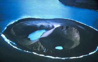 Water was present in two craters on Jolnir Island on 22 August 1966, less than two weeks after it ceased erupting. Jolnir was formed during repeated submarine eruptions that began in October 1965, immediately SW of the new island of Surtsey (upper right), rising above sea level and then being destroyed by erosion multiple times before it ceased activity on 10 August. No lava flows were produced, and a month after this photo was taken the loosely consolidated ash deposits that formed the island were eroded away.
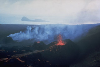 Lava flows issue from three small spatter cones on the island of Surtsey on 27 August 1966. Eruptions began in November 1963 and soon formed a new island, with lava effusion starting in April 1964. Eruptions at Iceland's newest island continued until 1967. The small island of Jolnir in the background began growing 800 m SW at the end of October 1965. It went through repeated episodes of growth and destruction before it ceased activity on 10 August 1966 and was eroded away by October.
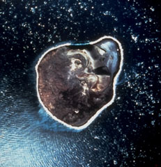 An April 1968 vertical aerial photo shows the ~2-km-wide island of Surtsey, less than one year after eruptive activity ceased. This island was formed during eruptions from November 1963 until June 1967 CE. Initial submarine eruptions rapidly produced a new island that became permanent after lava effusion began in 1964. The remains of two cinder cones and associated craters can be seen in the northeast (top) of the island. Several other ephemeral islands around Surtsey that were not armored by lava are now eroded beneath the ocean surface.
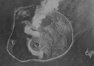 The island of Surtsey, seen here from the NW, developed during an eruption from 1963 to 1967 CE. This 1966 photo shows an active eruption from the floor of the Surtur cone (top), with a small steam plume towards the SE and fresh dark lavas on the eastern side of the island (top). The circular Surtungur vent (bottom cone), and its contiguous lava shield to the south were formed in 1964-65 during a period of lava effusion.
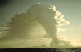 A column of steam and ash towers above the island of Heimaey on January 25, 1973, two days after the onset of its famous eruption. The mostly submarine Vestmannaeyjar is the southernmost volcanic system in the eastern volcanic zone of Iceland. It consists of a roughly 30 x 40 km group of volcanic islands and submarine cones occupying a shallow shelf off Iceland's southern coast. Vestmannaeyjar was the site of two of Iceland's most noted 20th-century eruptions, at Surtsey during 1963-67 and at Heimaey in 1973.
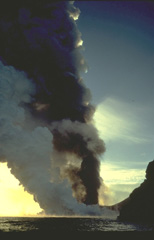 A thick column of steam rises above a lava flow that is entering the sea along the coast of Heimaey Island in January 1973. The lava flow reached the sea during the first day of the eruption. Concern that the flow would seal off the island's only harbor prompted the evacuation of all but essential personnel from the island. Nearly all of the island's 5000 residents were evacuated the first night of the eruption.
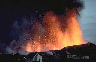 Lava fountains tower above the town of Vestmannaeyjar in March 1973. The eruption began on January 23, 1973, with explosive ejections from a NNE-SSW-trending, partly submarine fissure cutting Helgafell cone. Lava fountains built the Eldfell cinder cone and fed lava flows that reached the sea. Tephra buried more than 100 houses, and lava flows inundated parts of the town and threatened its harbor. The effects of vigorous efforts to slow the progress of the lava by spraying it with cold seawater are debated, but the flow stabilized at a point that improved the natural harbor.
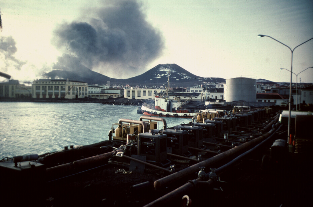
 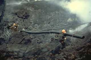 Workers carry pipes used during a massive attempt to cool the advancing lava flow produced by the 1973 eruption of Heimaey volcano. Water was pumped beginning on February 6, initially using a single large pump, and then larger pumps flown in from Iceland and the United States. On March 1, a pumping vessel arrived that sprayed water from the harbor. Cooling locally produced solidified barriers that diverted and stopped the lava flow. The lava flow created new land when it entered the sea and eventually improved the island's only harbor.
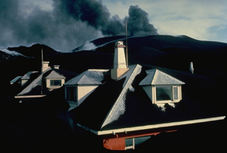 Eldfell cinder cone spews ash in the distance above the town of Vestmannaeyjar in April 1973. Thick ashfall deposits from the the volcano buried houses in the town. Most of the 5000 residents of the island were evacuated during the initial night of the eruption, which began on January 23. By the time the eruption ended on June 28, the volcano had ejected 0.02 cu km of ash, most of which fell out to sea. Following the eruption, 550 prefabricated houses were brought in from Scandinavian countries and Canada.
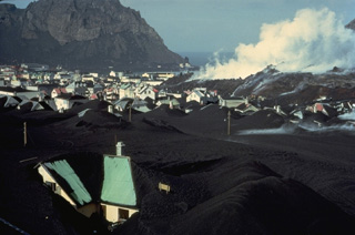 A steaming lava flow advances through the town of Vestmannaeyjar in April 1973. Houses in the foreground are partly buried by thick ashfall deposits from the Eldfell cinder cone, which began erupting on January 23. The lava flow advanced into the town's harbor, which lies between the flow and the cliff at the upper left. The flow covered a 300-m-wide, 700-m-long area in the NE part of town, burying 200 houses and buildings during a two-week period of extrusion in late March and early April.
 The island of Heimaey, about 10 km off the south coast of Iceland, is part of the Vestmannaeyjar volcanic system, which comprises numerous islands and submarine vents. Heimaey probably formed in the Holocene, through numerous eruptions. Here, an ash-laden eruption plume rises above a volcanic cone behind the town of Vestmannaeyjar in 1973. The water pumping operation in the foreground was designed to cool the front of an advancing lava flow that threatened the town and its harbor.
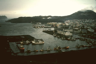 The harbor on the island of Heimaey is seen here in 1974, in the aftermath of an eruption that produced a lava flow that almost blocked the harbor entrance. The flow, which originated from a fissure extending from Eldfell cinder cone (upper right) forms the peninsula at the upper left. Extensive water pumping efforts were undertaken to cool and stop the advance of the flow; the diversion attempts were locally successful. The flow eventually stopped, after extending the shoreline up to 1.1 km over a 2.7-km-wide area, providing a more sheltered harbor.
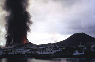 A dark ash column rises above lava fountains from a fissure eruption on the island of Heimaey in 1973. This explosive activity produced the Eldfell cinder cone (left), followed by effusion of lava flows which threatened the town of Vestmannaeyjar (foreground). Helgafell cone, on the right, formed during an eruption 5,900 years ago.
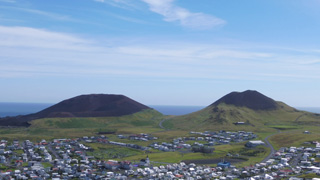 Vestmannaeyjar is a volcanic field about 20-25 km wide by 30-35 km long that forms an archipelago off the south coast of Iceland, about 60 km W of the town of Vik. The Eldfell (left) and Helgafell (right) scoria cones are seen here from the northern tip of Heimaey island in July 2019. Eldfell formed in 1973 and Helgafell around 5,900 BP.
The following 31 samples associated with this volcano can be found in the Smithsonian's NMNH Department of Mineral Sciences collections, and may be availble for research (contact the Rock and Ore Collections Manager). Catalog number links will open a window with more information.
| Catalog Number | Sample Description | Lava Source | Collection Date |
|---|---|---|---|
| NMNH 111319-1 | Lava | SURTSEY | -- |
| NMNH 111319-2 | Lava | SURTSEY | -- |
| NMNH 111319-3 | Lava | SURTSEY | -- |
| NMNH 111319-4 | Lava | SURTSEY | -- |
| NMNH 111319-5 | Volcanic Ash | SURTSEY | -- |
| NMNH 112356 | Olivine Basalt | SURTSEY | 1 Jan 1970 |
| NMNH 112357 | Basalt Xenolith | SURTSEY | 1 Jan 1970 |
| NMNH 112358 | Basalt | SURTSEY | 1 Jan 1970 |
| NMNH 112359 | Basalt | SURTSEY | 1 Jan 1970 |
| NMNH 112360 | Tuff | SURTSEY | 1 Jan 1970 |
| NMNH 112361 | Basalt | SURTSEY | 1 Jan 1970 |
| NMNH 113085 | Lava | HEIMAEY | -- |
| NMNH 113091-1 | Basalt | SURTSEY, SURTUR II VENT | -- |
| NMNH 113091-10 | Basalt | SURTSEY | -- |
| NMNH 113091-11 | Basalt | SURTSEY | -- |
| NMNH 113091-12 | Basalt | SURTSEY | -- |
| NMNH 113091-13 | Basalt | SURTSEY | -- |
| NMNH 113091-14 | Basalt | SURTSEY | -- |
| NMNH 113091-2 | Basalt | SURTSEY | -- |
| NMNH 113091-3 | Basalt | SURTSEY | -- |
| NMNH 113091-4 | Basalt | SURTSEY | -- |
| NMNH 113091-5 | Basalt | SURTSEY | -- |
| NMNH 113091-6 | Basalt | SURTSEY | -- |
| NMNH 113091-7 | Basalt | SURTSEY | -- |
| NMNH 113091-8 | Basalt | SURTSEY | -- |
| NMNH 113091-9 | Basalt | SURTSEY | -- |
| NMNH 113092-B | Tephra | SURTSEY | -- |
| NMNH 113092-C | Basalt | SURTSEY | -- |
| NMNH 115513 | Volcanic Bomb | HEIMAEY | -- |
| NMNH 117677-1 | Basalt | Heimaey | -- |
| NMNH 117677-2 | Basalt | Heimaey | -- |
| Catalogue of Icelandic Volcanoes (Link to Vestmannaeyjar) | The Catalogue of Icelandic Volcanoes is an interactive, web-based tool, containing information on volcanic systems that belong to the active volcanic zones of Iceland. It is a collaboration of the Icelandic Meteorological Office (the state volcano observatory), the Institute of Earth Sciences at the University of Iceland, and the Civil Protection Department of the National Commissioner of the Iceland Police, with contributions from a large number of specialists in Iceland and elsewhere. This official publication is intended to serve as an accurate and up-to-date source of information about active volcanoes in Iceland and their characteristics. The Catalogue forms a part of an integrated volcanic risk assessment project in Iceland GOSVÁ (commenced in 2012), as well as being part of the effort of FUTUREVOLC (2012-2016) on establishing an Icelandic volcano supersite. |
| Copernicus Browser | The Copernicus Browser replaced the Sentinel Hub Playground browser in 2023, to provide access to Earth observation archives from the Copernicus Data Space Ecosystem, the main distribution platform for data from the EU Copernicus missions. |
| MIROVA | Middle InfraRed Observation of Volcanic Activity (MIROVA) is a near real time volcanic hot-spot detection system based on the analysis of MODIS (Moderate Resolution Imaging Spectroradiometer) data. In particular, MIROVA uses the Middle InfraRed Radiation (MIR), measured over target volcanoes, in order to detect, locate and measure the heat radiation sourced from volcanic activity. |
| MODVOLC Thermal Alerts | Using infrared satellite Moderate Resolution Imaging Spectroradiometer (MODIS) data, scientists at the Hawai'i Institute of Geophysics and Planetology, University of Hawai'i, developed an automated system called MODVOLC to map thermal hot-spots in near real time. For each MODIS image, the algorithm automatically scans each 1 km pixel within it to check for high-temperature hot-spots. When one is found the date, time, location, and intensity are recorded. MODIS looks at every square km of the Earth every 48 hours, once during the day and once during the night, and the presence of two MODIS sensors in space allows at least four hot-spot observations every two days. Each day updated global maps are compiled to display the locations of all hot spots detected in the previous 24 hours. There is a drop-down list with volcano names which allow users to 'zoom-in' and examine the distribution of hot-spots at a variety of spatial scales. |
|
WOVOdat
Single Volcano View Temporal Evolution of Unrest Side by Side Volcanoes |
WOVOdat is a database of volcanic unrest; instrumentally and visually recorded changes in seismicity, ground deformation, gas emission, and other parameters from their normal baselines. It is sponsored by the World Organization of Volcano Observatories (WOVO) and presently hosted at the Earth Observatory of Singapore.
GVMID Data on Volcano Monitoring Infrastructure The Global Volcano Monitoring Infrastructure Database GVMID, is aimed at documenting and improving capabilities of volcano monitoring from the ground and space. GVMID should provide a snapshot and baseline view of the techniques and instrumentation that are in place at various volcanoes, which can be use by volcano observatories as reference to setup new monitoring system or improving networks at a specific volcano. These data will allow identification of what monitoring gaps exist, which can be then targeted by remote sensing infrastructure and future instrument deployments. |
| Volcanic Hazard Maps | The IAVCEI Commission on Volcanic Hazards and Risk has a Volcanic Hazard Maps database designed to serve as a resource for hazard mappers (or other interested parties) to explore how common issues in hazard map development have been addressed at different volcanoes, in different countries, for different hazards, and for different intended audiences. In addition to the comprehensive, searchable Volcanic Hazard Maps Database, this website contains information about diversity of volcanic hazard maps, illustrated using examples from the database. This site is for educational purposes related to volcanic hazard maps. Hazard maps found on this website should not be used for emergency purposes. For the most recent, official hazard map for a particular volcano, please seek out the proper institutional authorities on the matter. |
| IRIS seismic stations/networks | Incorporated Research Institutions for Seismology (IRIS) Data Services map showing the location of seismic stations from all available networks (permanent or temporary) within a radius of 0.18° (about 20 km at mid-latitudes) from the given location of Vestmannaeyjar. Users can customize a variety of filters and options in the left panel. Note that if there are no stations are known the map will default to show the entire world with a "No data matched request" error notice. |
| UNAVCO GPS/GNSS stations | Geodetic Data Services map from UNAVCO showing the location of GPS/GNSS stations from all available networks (permanent or temporary) within a radius of 20 km from the given location of Vestmannaeyjar. Users can customize the data search based on station or network names, location, and time window. Requires Adobe Flash Player. |
| DECADE Data | The DECADE portal, still in the developmental stage, serves as an example of the proposed interoperability between The Smithsonian Institution's Global Volcanism Program, the Mapping Gas Emissions (MaGa) Database, and the EarthChem Geochemical Portal. The Deep Earth Carbon Degassing (DECADE) initiative seeks to use new and established technologies to determine accurate global fluxes of volcanic CO2 to the atmosphere, but installing CO2 monitoring networks on 20 of the world's 150 most actively degassing volcanoes. The group uses related laboratory-based studies (direct gas sampling and analysis, melt inclusions) to provide new data for direct degassing of deep earth carbon to the atmosphere. |
| Large Eruptions of Vestmannaeyjar | Information about large Quaternary eruptions (VEI >= 4) is cataloged in the Large Magnitude Explosive Volcanic Eruptions (LaMEVE) database of the Volcano Global Risk Identification and Analysis Project (VOGRIPA). |
| EarthChem | EarthChem develops and maintains databases, software, and services that support the preservation, discovery, access and analysis of geochemical data, and facilitate their integration with the broad array of other available earth science parameters. EarthChem is operated by a joint team of disciplinary scientists, data scientists, data managers and information technology developers who are part of the NSF-funded data facility Integrated Earth Data Applications (IEDA). IEDA is a collaborative effort of EarthChem and the Marine Geoscience Data System (MGDS). |