


After a series of meetings between the Icelandic Meteorological Office, the University of Iceland, and Iceland Geosurvey, the Iceland Department of Civil Protection and Emergency Management stated on 13 July that Öræfajökull has shown clear signs of unrest for at least the past year and a half. The report noted ongoing inflation and increased seismicity, despite a decrease in geothermal activity since December 2017. The volume change since the beginning of the unrest was about 10 million cubic meters, likely from an injection of new magma.
2018: May
| July
2017: November
| December
After a series of meetings between the Icelandic Meteorological Office, the University of Iceland, and Iceland Geosurvey, the Iceland Department of Civil Protection and Emergency Management stated on 13 July that Öræfajökull has shown clear signs of unrest for at least the past year and a half. The report noted ongoing inflation and increased seismicity, despite a decrease in geothermal activity since December 2017. The volume change since the beginning of the unrest was about 10 million cubic meters, likely from an injection of new magma.
On 4 May, the Icelandic Met Office reduced the Aviation Color Code at Öræfajökull from Yellow to Green due to signs of reduced activity. Since September 2017 there has been less earthquake activity, stable hydrological and geochemical measurements, and reduced geothermal heat output. There has been possible minor ongoing inflation, but no signs of an imminent eruption.
Source: Icelandic Meteorological Office (IMO)
On 22 December IMO reported that activity at Öræfajökull had been fairly stable during the previous weeks, though still above background levels; the Aviation Color Code remained at Yellow. In December the largest earthquake detected was a M2.5, but most events were smaller than M1. Earthquakes were located close to the caldera at depths between 2 and 10 km.
Source: Icelandic Meteorological Office (IMO)
The Icelandic Meteorological Office (IMO) reported that on 17 November the Aviation Color Code for Öræfajökull was raised to Yellow because satellite images and photos showed that a new ice cauldron had formed within the caldera the previous week. The new cauldron was about 1 km in diameter and 15-20 m deep, and signified a recent increase in geothermal activity. Scientists conducted an overflight on 18 November; in addition, while on the ground, they took water samples, measurements of electrical conductivity, and gas levels at the Kvíárjökull outlet-glacier, a valley glacier on the SE flank of Öræfajökull. There was no obvious sign of flooding in the Kvíá river. A sulfur odor, which had been reported for about a week, was also noted. An increase in the seismic activity was recorded for the last few months (the largest earthquake, an M 3.4, occurred on the 3 October), but was low for the past few days. IMO noted that there were no signs of an imminent volcanic eruption, though there was considerable uncertainty about how the situation will evolve.
Source: Icelandic Meteorological Office (IMO)
The Global Volcanism Program has no Bulletin Reports available for Öræfajökull.
This compilation of synonyms and subsidiary features may not be comprehensive. Features are organized into four major categories: Cones, Craters, Domes, and Thermal Features. Synonyms of features appear indented below the primary name. In some cases additional feature type, elevation, or location details are provided.
Synonyms |
||||
| Knappafellsjokull | Hnappafellsjokull | Orfialdsjokull | ||||
Cones |
||||
| Feature Name | Feature Type | Elevation | Latitude | Longitude |
| Hofsfjall | Cone | 744 m | ||
| Storhofdi | Cone | 784 m | ||
Domes |
||||
| Feature Name | Feature Type | Elevation | Latitude | Longitude |
| Hvannadalshnjukur | Dome | |||
|
|
||||||||||||||||||||||||||
There is data available for 2 confirmed Holocene eruptive periods.
1727 Aug 3 - 1728 May 1 ± 30 days Confirmed Eruption Max VEI: 4
| Episode 1 | Eruption Episode | Caldera, west flank (to 1100 m) | |||||||||||||||||||||||||||||||||||||||||||||||||
|---|---|---|---|---|---|---|---|---|---|---|---|---|---|---|---|---|---|---|---|---|---|---|---|---|---|---|---|---|---|---|---|---|---|---|---|---|---|---|---|---|---|---|---|---|---|---|---|---|---|---|
| 1727 Aug 3 - 1728 May 1 ± 30 days | Evidence from Observations: Reported | |||||||||||||||||||||||||||||||||||||||||||||||||
|
List of 8 Events for Episode 1 at Caldera, west flank (to 1100 m)
| ||||||||||||||||||||||||||||||||||||||||||||||||||
1362 Jun 5 ± 4 days - 1362 Oct 15 ± 45 days Confirmed Eruption Max VEI: 5
| Episode 1 | Eruption Episode | |||||||||||||||||||||||||||||||||||||||||||||||||||||||||||||||||
|---|---|---|---|---|---|---|---|---|---|---|---|---|---|---|---|---|---|---|---|---|---|---|---|---|---|---|---|---|---|---|---|---|---|---|---|---|---|---|---|---|---|---|---|---|---|---|---|---|---|---|---|---|---|---|---|---|---|---|---|---|---|---|---|---|---|
| 1362 Jun 5 ± 4 days - 1362 Oct 15 ± 45 days | Evidence from Observations: Reported | ||||||||||||||||||||||||||||||||||||||||||||||||||||||||||||||||
|
List of 11 Events for Episode 1
| |||||||||||||||||||||||||||||||||||||||||||||||||||||||||||||||||
There is no Deformation History data available for Öræfajökull.
There is no Emissions History data available for Öræfajökull.
The maps shown below have been scanned from the GVP map archives and include the volcano on this page. Clicking on the small images will load the full 300 dpi map. Very small-scale maps (such as world maps) are not included. The maps database originated over 30 years ago, but was only recently updated and connected to our main database. We welcome users to tell us if they see incorrect information or other problems with the maps; please use the Contact GVP link at the bottom of the page to send us email.
The following 2 samples associated with this volcano can be found in the Smithsonian's NMNH Department of Mineral Sciences collections, and may be availble for research (contact the Rock and Ore Collections Manager). Catalog number links will open a window with more information.
| Catalog Number | Sample Description | Lava Source | Collection Date |
|---|---|---|---|
| NMNH 117551-1 | Obsidian | -- | -- |
| NMNH 117551-12 | Obsidian | Hof rhyolite dome | -- |
| Catalogue of Icelandic Volcanoes (Link to Öræfajökull) | The Catalogue of Icelandic Volcanoes is an interactive, web-based tool, containing information on volcanic systems that belong to the active volcanic zones of Iceland. It is a collaboration of the Icelandic Meteorological Office (the state volcano observatory), the Institute of Earth Sciences at the University of Iceland, and the Civil Protection Department of the National Commissioner of the Iceland Police, with contributions from a large number of specialists in Iceland and elsewhere. This official publication is intended to serve as an accurate and up-to-date source of information about active volcanoes in Iceland and their characteristics. The Catalogue forms a part of an integrated volcanic risk assessment project in Iceland GOSVÁ (commenced in 2012), as well as being part of the effort of FUTUREVOLC (2012-2016) on establishing an Icelandic volcano supersite. |
| Copernicus Browser | The Copernicus Browser replaced the Sentinel Hub Playground browser in 2023, to provide access to Earth observation archives from the Copernicus Data Space Ecosystem, the main distribution platform for data from the EU Copernicus missions. |
| MIROVA | Middle InfraRed Observation of Volcanic Activity (MIROVA) is a near real time volcanic hot-spot detection system based on the analysis of MODIS (Moderate Resolution Imaging Spectroradiometer) data. In particular, MIROVA uses the Middle InfraRed Radiation (MIR), measured over target volcanoes, in order to detect, locate and measure the heat radiation sourced from volcanic activity. |
| MODVOLC Thermal Alerts | Using infrared satellite Moderate Resolution Imaging Spectroradiometer (MODIS) data, scientists at the Hawai'i Institute of Geophysics and Planetology, University of Hawai'i, developed an automated system called MODVOLC to map thermal hot-spots in near real time. For each MODIS image, the algorithm automatically scans each 1 km pixel within it to check for high-temperature hot-spots. When one is found the date, time, location, and intensity are recorded. MODIS looks at every square km of the Earth every 48 hours, once during the day and once during the night, and the presence of two MODIS sensors in space allows at least four hot-spot observations every two days. Each day updated global maps are compiled to display the locations of all hot spots detected in the previous 24 hours. There is a drop-down list with volcano names which allow users to 'zoom-in' and examine the distribution of hot-spots at a variety of spatial scales. |
|
WOVOdat
Single Volcano View Temporal Evolution of Unrest Side by Side Volcanoes |
WOVOdat is a database of volcanic unrest; instrumentally and visually recorded changes in seismicity, ground deformation, gas emission, and other parameters from their normal baselines. It is sponsored by the World Organization of Volcano Observatories (WOVO) and presently hosted at the Earth Observatory of Singapore.
GVMID Data on Volcano Monitoring Infrastructure The Global Volcano Monitoring Infrastructure Database GVMID, is aimed at documenting and improving capabilities of volcano monitoring from the ground and space. GVMID should provide a snapshot and baseline view of the techniques and instrumentation that are in place at various volcanoes, which can be use by volcano observatories as reference to setup new monitoring system or improving networks at a specific volcano. These data will allow identification of what monitoring gaps exist, which can be then targeted by remote sensing infrastructure and future instrument deployments. |
| Volcanic Hazard Maps | The IAVCEI Commission on Volcanic Hazards and Risk has a Volcanic Hazard Maps database designed to serve as a resource for hazard mappers (or other interested parties) to explore how common issues in hazard map development have been addressed at different volcanoes, in different countries, for different hazards, and for different intended audiences. In addition to the comprehensive, searchable Volcanic Hazard Maps Database, this website contains information about diversity of volcanic hazard maps, illustrated using examples from the database. This site is for educational purposes related to volcanic hazard maps. Hazard maps found on this website should not be used for emergency purposes. For the most recent, official hazard map for a particular volcano, please seek out the proper institutional authorities on the matter. |
| IRIS seismic stations/networks | Incorporated Research Institutions for Seismology (IRIS) Data Services map showing the location of seismic stations from all available networks (permanent or temporary) within a radius of 0.18° (about 20 km at mid-latitudes) from the given location of Öræfajökull. Users can customize a variety of filters and options in the left panel. Note that if there are no stations are known the map will default to show the entire world with a "No data matched request" error notice. |
| UNAVCO GPS/GNSS stations | Geodetic Data Services map from UNAVCO showing the location of GPS/GNSS stations from all available networks (permanent or temporary) within a radius of 20 km from the given location of Öræfajökull. Users can customize the data search based on station or network names, location, and time window. Requires Adobe Flash Player. |
| DECADE Data | The DECADE portal, still in the developmental stage, serves as an example of the proposed interoperability between The Smithsonian Institution's Global Volcanism Program, the Mapping Gas Emissions (MaGa) Database, and the EarthChem Geochemical Portal. The Deep Earth Carbon Degassing (DECADE) initiative seeks to use new and established technologies to determine accurate global fluxes of volcanic CO2 to the atmosphere, but installing CO2 monitoring networks on 20 of the world's 150 most actively degassing volcanoes. The group uses related laboratory-based studies (direct gas sampling and analysis, melt inclusions) to provide new data for direct degassing of deep earth carbon to the atmosphere. |
| Large Eruptions of Öræfajökull | Information about large Quaternary eruptions (VEI >= 4) is cataloged in the Large Magnitude Explosive Volcanic Eruptions (LaMEVE) database of the Volcano Global Risk Identification and Analysis Project (VOGRIPA). |
| EarthChem | EarthChem develops and maintains databases, software, and services that support the preservation, discovery, access and analysis of geochemical data, and facilitate their integration with the broad array of other available earth science parameters. EarthChem is operated by a joint team of disciplinary scientists, data scientists, data managers and information technology developers who are part of the NSF-funded data facility Integrated Earth Data Applications (IEDA). IEDA is a collaborative effort of EarthChem and the Marine Geoscience Data System (MGDS). |
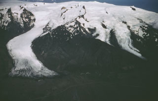 Öræfajökull is located near the SE coast of Iceland, viewed here from the west, with the Svinafellsjökull glacier (left) descending from the central icecap nearly to the coastal road. A subglacial caldera, 4 x 5 km, truncates the summit. Large eruptions in 1362 and 1727-28 were accompanied by jökulhlaups (glacier outburst floods) that caused property damage and fatalities.