Undated explosive volcanism at depth on Arctic mid-ocean ridge
A sonar survey in 2001 along the ultraslow-spreading Gakkel Ridge (formerly known as the Nansen Cordillera and Arctic Mid-Ocean Ridge) by the USS Hawkbill submarine and the U.S. Coast Guard icebreaker Healy revealed two previously undiscovered volcanoes beneath the pack ice of the Arctic Ocean (BGVN 26:03). In July 2007, a research team led by Woods Hole Oceanographic Institution (WHOI) uncovered evidence of explosive volcanic eruptions in the same area of the seafloor.
At a depth of ~4 km, researchers found fresh, unweathered, jagged, glassy fragments of rock (pyroclastic deposits) spread out over an area of ~10 km2 around a series of small volcanic craters on the Gakkel Ridge (figure 1). According to WHOI geophysicist Rob Reves-Sohn, chief scientist of the expedition, as quoted in the 14 August 2008 issue of Oceanus, "These are the first pyroclastic deposits we've ever found in such deep water, at oppressive pressures that inhibit the formation of steam, and many people thought this was not possible. This means that a tremendous blast of carbon dioxide was released into the water column during the explosive eruption." Although no speculation was made by the scientists as to the age of the eruption(s) that caused these pyroclastics, the fresh nature of these surficial materials argue to their recency.
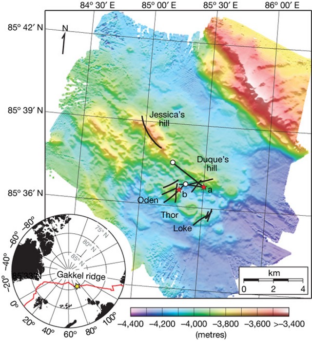 |
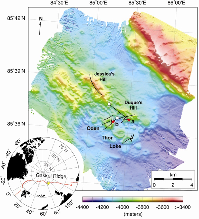
Figure 1. Detailed bathymetry (30-m grid spacing) of the Gakkel Ridge at 85°E in the Arctic Ocean based on July 2007 WHOI research cruise. The inset map shows the location of the 85°E segment (yellow star) along the Gakkel ridge (red line) in the Arctic basin. The main panel shows illuminated, color bathymetry of the 85°E segment acquired during the Arctic Gakkel Vents (AGAVE) expedition. The axial valley contains large numbers of distinctive, cratered volcanoes, including a cone on a fault terrace of the northern valley wall. Photographic bottom surveys were conducted along profiles shown as thin black lines on the map. Pyroclastic deposit samples were collected at sites shown by white circles, and the photographs shown in figure 2 were taken at the sites shown by the lettered (red) stars. Named features include two volcanic ridges in the center of the axial valley (Jessica's hill and Duque's hill), and three cratered volcanoes along a ridge-parallel fissure to the S (Oden, Thor, and Loke). Courtesy of Sohn and others (2008). |
According to Cochran (2008), the Gakkel Ridge is the slowest spreading portion of the global system of mid-ocean ridges. Total spreading rates vary from 12.8 mm/year near Greenland to 6.5 mm/year at the Siberian margin.
A recent article by Sohn and others (2008) concerning the July 2007 expedition noted that roughly 60% of the Earth's outer surface is composed of oceanic crust formed by volcanic processes at mid-ocean ridges. Although only a small fraction of this vast volcanic terrain has been visually surveyed or sampled, the available evidence suggests that explosive eruptions are rare on mid-ocean ridges, particularly at depths below the critical point for seawater (a depth of ~ 3,000 m). A pyroclastic deposit has never been observed on the sea floor below 3,000 m, presumably because the volatile content of mid-ocean-ridge basalts is generally too low to produce the gas fractions required for fragmenting a magma at such high hydrostatic pressure. Liu and others (2008) reported on recent analyses of many major and trace element collected from Gakkel Ridge.
The July 2007 expedition acquired photographs and video images of 'zero-age' volcanic terrain along the ridge and beneath the ice-cover ocean's surface. The axial valley at 4,000 m water depth was blanketed with unconsolidated pyroclastic deposits. Those included bubble-wall fragments (limu o Pele, also know as Pele's seaweed?fragments of large glass bubbles that shatter into pieces of curved, paper-thin, bubble walls), covering a large (greater than 10 km2) area (figure 2). At least 13.5 weight percent CO2 is necessary to fragment magma at these depths, which is about tenfold above the highest values previously measured in a mid-ocean-ridge basalt.
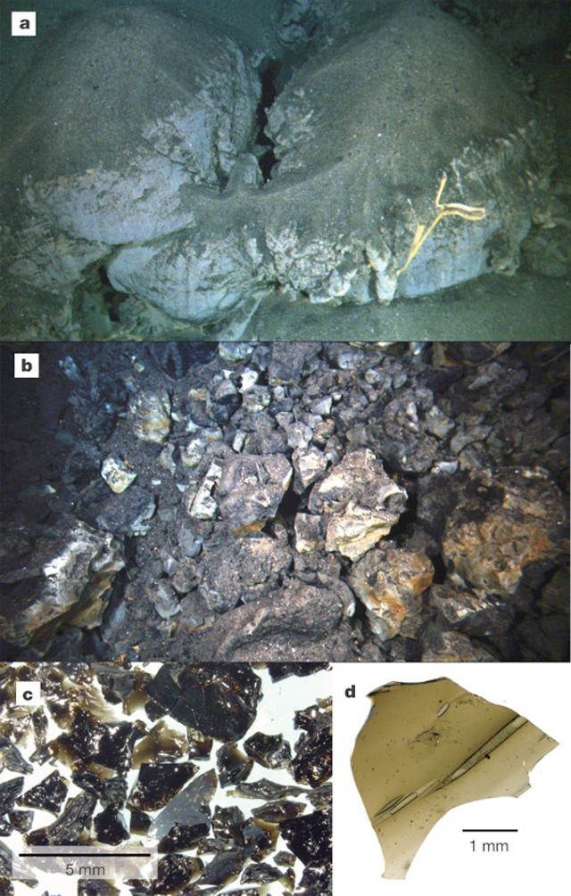 |
Figure 2. Photographs of pyroclastic deposits taken during July 2007 WHOI research cruise. (a) One frame from a high-definition video camera taken on the S side of Duque's hill (see figure 1 for location). About 10 cm (visually estimated and confirmed during sampling) of pyroclastic material is piled atop a high-standing, weathered, pillow feature. The exoskeleton of an as yet unidentified species of hexactinellid sponge (glass sponge, or a sponge with a skeleton made of 4- and/or 6-pointed siliceous spicules) is visible in the foreground. (b) High-definition video frame grab of talus blocks possibly representing ejecta from a vulcanian explosion on Oden volcano (see figure 1 for location). (c) Glassy, granular, pyroclastic material. (d) Bubble wall fragment from pyroclastic deposit. Courtesy of Sohn and others (2008). |
Sohn and others (2008) note that these observations raise important questions about the accumulation and discharge of magmatic volatiles at ultraslow spreading rates on the Gakkel ridge. They also demonstrate that large-scale pyroclastic activity is possible along even the deepest portions of the global mid-ocean ridge volcanic system.
References. Sohn, R.A., Willis, C., Humphris, S., Shank, T.M., Singh, H., Edmonds, H.N., Kunz, C., Hedman, U., Helmke, E., Jakuba, M., Liljebladh, B., Linder, J., Murphy, C., Nakamura, K., Sato, T., Schlindwein, V., Stranne, C., Tausenfreund, M., Upchurch, L., Winsor, P., Jakobsson., M., and Soule, A., 2008, Explosive volcanism on the ultraslow-spreading Gakkel ridge, Arctic Ocean: Nature, v. 453, p. 1236-1238 (doi:10.1038/nature07075).
Cochran, J.R., 2008, Seamount volcanism along the Gakkel Ridge, Arctic Ocean, Geophysical Journal International, v. 174, no. 3, p. 1153-1173.
Liu,C-Z, Snow, J.E., Hellebrand, E., Br?gmann, G., von der Handt, A., B?chl, A., and Hofmann, A.W., 2008, Ancient, highly heterogeneous mantle beneath Gakkel ridge, Arctic Ocean: Nature, v. 452, p. 311-316 (doi:10.1038/nature06688).
Carlowicz, M., 2008, Deeply submerged volcanoes blow their tops: Telltale rocks reveal evidence of a phenomenon scientists thought was impossible: Oceanus, 14 August 2008.
Information Contacts: Oceanus: The Online Magazine of Research from Woods Hole Oceanographic Institution (URL: http://www.whoi.edu/oceanus/).
The Global Volcanism Program has no Weekly Reports available for East Gakkel Ridge at 85°E.
Reports are organized chronologically and indexed below by Month/Year (Publication Volume:Number), and include a one-line summary. Click on the index link or scroll down to read the reports.
Two recently active volcanoes discovered beneath Arctic Ocean pack ice
A sonar survey along the ultraslow-spreading Gakkel Ridge by the USS Hawkbill submarine revealed two previously undiscovered volcanoes beneath the pack ice of the Arctic Ocean. Lineated magnetic anomalies over the entire ridge suggested that seafloor volcanism occurred there, but theoretical modeling predicted that melt production should be extremely low given the ~1.0-1.3 cm/year rate at which the ridge spreads. Sidescan and bathymetric data from the East Gakkel Ridge survey showed two amorphously shaped topographic highs with 1,000 m (eastern volcano) and 500 m (western volcano) of relative relief, with a highly reflective acoustic character. The high reflectivity was interpreted to indicate a lack of significant sedimentary cover on young basaltic flows.
Edwards and others (2001) reported that "portions of the strongly reflective regions . . . abut lineaments, consistent with the ponding of lava against fault scarps. Terminations of acoustically reflective terrain in regions devoid of lineaments have shapes characteristic of lava flow fronts . . .. These flow toes are radially distributed about the two topographic highs. The morphology of the strongly reflective regions is consistent with submarine volcanic flow systems mapped at other mid-ocean ridges by acoustic and optical [methods] . . . . The two acoustically reflective regions are thus probably volcanoes that are largely devoid of sediment cover, and therefore erupted recently. The presence of these two young volcanoes covering approximately 20% of the 3,750 km2 surveyed along . . . the eastern Gakkel Ridge, proves that significant volcanism occurs at ultraslow spreading rates."
During January-September 1999 global seismic networks detected an earthquake swarm corresponding to the approximate location of the W volcano discovered along the East Gakkel Ridge (86°N, 85°E). About 75% of the swarm occurred before the end of May. Edwards and others (2001) noted that "The correlation between the locations of the earthquake epicenters and the location of the strongly reflective, untectonized W volcano together with the volcanic character of the seismic record provide evidence that lava erupted on the E Gakkel Ridge . . . . Because 12-kHz sonars can penetrate through thin sediments covering acoustically reflective lavas, it is possible that no eruption occurred on Gakkel Ridge in 1999; however, historical global seismic records indicate that this is the only earthquake swarm detected on Gakkel Ridge in about 100 years."
Reference. Edwards, M.H., Kurras, G.J., Tolstoy, M., Bohnenstiehl, D.R., Coakley, B.J., and Cochran, J.R., 2001, Evidence of recent volcanic activity on the ultraslow-spreading Gakkel Ridge: Nature, v. 409, no. 6822, p. 808-812.
Information Contacts: M.H. Edwards, Hawaii Institute of Geophysics and Planetology, School of Ocean and Earth Science and Technology, University of Hawaii at Manoa, POST 815, 1680 East-West Road, Honolulu, Hawaii 96822 USA (URL: http://www.soest.hawaii.edu/HMRG/cms/).
Undated explosive volcanism at depth on Arctic mid-ocean ridge
A sonar survey in 2001 along the ultraslow-spreading Gakkel Ridge (formerly known as the Nansen Cordillera and Arctic Mid-Ocean Ridge) by the USS Hawkbill submarine and the U.S. Coast Guard icebreaker Healy revealed two previously undiscovered volcanoes beneath the pack ice of the Arctic Ocean (BGVN 26:03). In July 2007, a research team led by Woods Hole Oceanographic Institution (WHOI) uncovered evidence of explosive volcanic eruptions in the same area of the seafloor.
At a depth of ~4 km, researchers found fresh, unweathered, jagged, glassy fragments of rock (pyroclastic deposits) spread out over an area of ~10 km2 around a series of small volcanic craters on the Gakkel Ridge (figure 1). According to WHOI geophysicist Rob Reves-Sohn, chief scientist of the expedition, as quoted in the 14 August 2008 issue of Oceanus, "These are the first pyroclastic deposits we've ever found in such deep water, at oppressive pressures that inhibit the formation of steam, and many people thought this was not possible. This means that a tremendous blast of carbon dioxide was released into the water column during the explosive eruption." Although no speculation was made by the scientists as to the age of the eruption(s) that caused these pyroclastics, the fresh nature of these surficial materials argue to their recency.
|
Figure 1. Detailed bathymetry (30-m grid spacing) of the Gakkel Ridge at 85°E in the Arctic Ocean based on July 2007 WHOI research cruise. The inset map shows the location of the 85°E segment (yellow star) along the Gakkel ridge (red line) in the Arctic basin. The main panel shows illuminated, color bathymetry of the 85°E segment acquired during the Arctic Gakkel Vents (AGAVE) expedition. The axial valley contains large numbers of distinctive, cratered volcanoes, including a cone on a fault terrace of the northern valley wall. Photographic bottom surveys were conducted along profiles shown as thin black lines on the map. Pyroclastic deposit samples were collected at sites shown by white circles, and the photographs shown in figure 2 were taken at the sites shown by the lettered (red) stars. Named features include two volcanic ridges in the center of the axial valley (Jessica's hill and Duque's hill), and three cratered volcanoes along a ridge-parallel fissure to the S (Oden, Thor, and Loke). Courtesy of Sohn and others (2008). |
According to Cochran (2008), the Gakkel Ridge is the slowest spreading portion of the global system of mid-ocean ridges. Total spreading rates vary from 12.8 mm/year near Greenland to 6.5 mm/year at the Siberian margin.
A recent article by Sohn and others (2008) concerning the July 2007 expedition noted that roughly 60% of the Earth's outer surface is composed of oceanic crust formed by volcanic processes at mid-ocean ridges. Although only a small fraction of this vast volcanic terrain has been visually surveyed or sampled, the available evidence suggests that explosive eruptions are rare on mid-ocean ridges, particularly at depths below the critical point for seawater (a depth of ~ 3,000 m). A pyroclastic deposit has never been observed on the sea floor below 3,000 m, presumably because the volatile content of mid-ocean-ridge basalts is generally too low to produce the gas fractions required for fragmenting a magma at such high hydrostatic pressure. Liu and others (2008) reported on recent analyses of many major and trace element collected from Gakkel Ridge.
The July 2007 expedition acquired photographs and video images of 'zero-age' volcanic terrain along the ridge and beneath the ice-cover ocean's surface. The axial valley at 4,000 m water depth was blanketed with unconsolidated pyroclastic deposits. Those included bubble-wall fragments (limu o Pele, also know as Pele's seaweed?fragments of large glass bubbles that shatter into pieces of curved, paper-thin, bubble walls), covering a large (greater than 10 km2) area (figure 2). At least 13.5 weight percent CO2 is necessary to fragment magma at these depths, which is about tenfold above the highest values previously measured in a mid-ocean-ridge basalt.
|
Figure 2. Photographs of pyroclastic deposits taken during July 2007 WHOI research cruise. (a) One frame from a high-definition video camera taken on the S side of Duque's hill (see figure 1 for location). About 10 cm (visually estimated and confirmed during sampling) of pyroclastic material is piled atop a high-standing, weathered, pillow feature. The exoskeleton of an as yet unidentified species of hexactinellid sponge (glass sponge, or a sponge with a skeleton made of 4- and/or 6-pointed siliceous spicules) is visible in the foreground. (b) High-definition video frame grab of talus blocks possibly representing ejecta from a vulcanian explosion on Oden volcano (see figure 1 for location). (c) Glassy, granular, pyroclastic material. (d) Bubble wall fragment from pyroclastic deposit. Courtesy of Sohn and others (2008). |
Sohn and others (2008) note that these observations raise important questions about the accumulation and discharge of magmatic volatiles at ultraslow spreading rates on the Gakkel ridge. They also demonstrate that large-scale pyroclastic activity is possible along even the deepest portions of the global mid-ocean ridge volcanic system.
References. Sohn, R.A., Willis, C., Humphris, S., Shank, T.M., Singh, H., Edmonds, H.N., Kunz, C., Hedman, U., Helmke, E., Jakuba, M., Liljebladh, B., Linder, J., Murphy, C., Nakamura, K., Sato, T., Schlindwein, V., Stranne, C., Tausenfreund, M., Upchurch, L., Winsor, P., Jakobsson., M., and Soule, A., 2008, Explosive volcanism on the ultraslow-spreading Gakkel ridge, Arctic Ocean: Nature, v. 453, p. 1236-1238 (doi:10.1038/nature07075).
Cochran, J.R., 2008, Seamount volcanism along the Gakkel Ridge, Arctic Ocean, Geophysical Journal International, v. 174, no. 3, p. 1153-1173.
Liu,C-Z, Snow, J.E., Hellebrand, E., Br?gmann, G., von der Handt, A., B?chl, A., and Hofmann, A.W., 2008, Ancient, highly heterogeneous mantle beneath Gakkel ridge, Arctic Ocean: Nature, v. 452, p. 311-316 (doi:10.1038/nature06688).
Carlowicz, M., 2008, Deeply submerged volcanoes blow their tops: Telltale rocks reveal evidence of a phenomenon scientists thought was impossible: Oceanus, 14 August 2008.
Information Contacts: Oceanus: The Online Magazine of Research from Woods Hole Oceanographic Institution (URL: http://www.whoi.edu/oceanus/).
|
|
||||||||||||||||||||||||||
There is data available for 1 confirmed Holocene eruptive periods.
1999 Apr 5 (?) - 1999 Apr 15 (?) Confirmed Eruption (Explosive / Effusive) VEI: 0
| Episode 1 | Eruption (Explosive / Effusive) | East Gakkel Ridge | |||||||||||||||||||
|---|---|---|---|---|---|---|---|---|---|---|---|---|---|---|---|---|---|---|---|---|
| 1999 Apr 5 (?) - 1999 Apr 15 (?) | Evidence from Observations: Seismicity | |||||||||||||||||||
|
List of 2 Events for Episode 1 at East Gakkel Ridge
|
||||||||||||||||||||
This compilation of synonyms and subsidiary features may not be comprehensive. Features are organized into four major categories: Cones, Craters, Domes, and Thermal Features. Synonyms of features appear indented below the primary name. In some cases additional feature type, elevation, or location details are provided.
Cones |
||||
| Feature Name | Feature Type | Elevation | Latitude | Longitude |
| Loke | Cone | 85° 35' 30.00" N | 85° 30' 0.00" E | |
| Oden | Cone - Crater | 85° 36' 30.00" N | 85° 15' 0.00" E | |
| Thor | Cone | 85° 36' 0.00" N | 85° 25' 0.00" E | |
There are no samples for East Gakkel Ridge at 85°E in the Smithsonian's NMNH Department of Mineral Sciences Rock and Ore collection.
| Copernicus Browser | The Copernicus Browser replaced the Sentinel Hub Playground browser in 2023, to provide access to Earth observation archives from the Copernicus Data Space Ecosystem, the main distribution platform for data from the EU Copernicus missions. |
| MIROVA | Middle InfraRed Observation of Volcanic Activity (MIROVA) is a near real time volcanic hot-spot detection system based on the analysis of MODIS (Moderate Resolution Imaging Spectroradiometer) data. In particular, MIROVA uses the Middle InfraRed Radiation (MIR), measured over target volcanoes, in order to detect, locate and measure the heat radiation sourced from volcanic activity. |
| MODVOLC Thermal Alerts | Using infrared satellite Moderate Resolution Imaging Spectroradiometer (MODIS) data, scientists at the Hawai'i Institute of Geophysics and Planetology, University of Hawai'i, developed an automated system called MODVOLC to map thermal hot-spots in near real time. For each MODIS image, the algorithm automatically scans each 1 km pixel within it to check for high-temperature hot-spots. When one is found the date, time, location, and intensity are recorded. MODIS looks at every square km of the Earth every 48 hours, once during the day and once during the night, and the presence of two MODIS sensors in space allows at least four hot-spot observations every two days. Each day updated global maps are compiled to display the locations of all hot spots detected in the previous 24 hours. There is a drop-down list with volcano names which allow users to 'zoom-in' and examine the distribution of hot-spots at a variety of spatial scales. |
|
WOVOdat
Single Volcano View Temporal Evolution of Unrest Side by Side Volcanoes |
WOVOdat is a database of volcanic unrest; instrumentally and visually recorded changes in seismicity, ground deformation, gas emission, and other parameters from their normal baselines. It is sponsored by the World Organization of Volcano Observatories (WOVO) and presently hosted at the Earth Observatory of Singapore.
GVMID Data on Volcano Monitoring Infrastructure The Global Volcano Monitoring Infrastructure Database GVMID, is aimed at documenting and improving capabilities of volcano monitoring from the ground and space. GVMID should provide a snapshot and baseline view of the techniques and instrumentation that are in place at various volcanoes, which can be use by volcano observatories as reference to setup new monitoring system or improving networks at a specific volcano. These data will allow identification of what monitoring gaps exist, which can be then targeted by remote sensing infrastructure and future instrument deployments. |
| Volcanic Hazard Maps | The IAVCEI Commission on Volcanic Hazards and Risk has a Volcanic Hazard Maps database designed to serve as a resource for hazard mappers (or other interested parties) to explore how common issues in hazard map development have been addressed at different volcanoes, in different countries, for different hazards, and for different intended audiences. In addition to the comprehensive, searchable Volcanic Hazard Maps Database, this website contains information about diversity of volcanic hazard maps, illustrated using examples from the database. This site is for educational purposes related to volcanic hazard maps. Hazard maps found on this website should not be used for emergency purposes. For the most recent, official hazard map for a particular volcano, please seek out the proper institutional authorities on the matter. |
| IRIS seismic stations/networks | Incorporated Research Institutions for Seismology (IRIS) Data Services map showing the location of seismic stations from all available networks (permanent or temporary) within a radius of 0.18° (about 20 km at mid-latitudes) from the given location of East Gakkel Ridge at 85°E. Users can customize a variety of filters and options in the left panel. Note that if there are no stations are known the map will default to show the entire world with a "No data matched request" error notice. |
| UNAVCO GPS/GNSS stations | Geodetic Data Services map from UNAVCO showing the location of GPS/GNSS stations from all available networks (permanent or temporary) within a radius of 20 km from the given location of East Gakkel Ridge at 85°E. Users can customize the data search based on station or network names, location, and time window. Requires Adobe Flash Player. |
| DECADE Data | The DECADE portal, still in the developmental stage, serves as an example of the proposed interoperability between The Smithsonian Institution's Global Volcanism Program, the Mapping Gas Emissions (MaGa) Database, and the EarthChem Geochemical Portal. The Deep Earth Carbon Degassing (DECADE) initiative seeks to use new and established technologies to determine accurate global fluxes of volcanic CO2 to the atmosphere, but installing CO2 monitoring networks on 20 of the world's 150 most actively degassing volcanoes. The group uses related laboratory-based studies (direct gas sampling and analysis, melt inclusions) to provide new data for direct degassing of deep earth carbon to the atmosphere. |
| Large Eruptions of East Gakkel Ridge at 85°E | Information about large Quaternary eruptions (VEI >= 4) is cataloged in the Large Magnitude Explosive Volcanic Eruptions (LaMEVE) database of the Volcano Global Risk Identification and Analysis Project (VOGRIPA). |
| EarthChem | EarthChem develops and maintains databases, software, and services that support the preservation, discovery, access and analysis of geochemical data, and facilitate their integration with the broad array of other available earth science parameters. EarthChem is operated by a joint team of disciplinary scientists, data scientists, data managers and information technology developers who are part of the NSF-funded data facility Integrated Earth Data Applications (IEDA). IEDA is a collaborative effort of EarthChem and the Marine Geoscience Data System (MGDS). |


 Detailed bathymetry of the East Gakkel Ridge at 85°E in the Arctic Ocean. The inset map shows the location of the 85°E segment (yellow star) along the Gakkel Ridge (red line). The main panel shows illuminated color bathymetry (30-m grid spacing) of the 85°E segment acquired during the AGAVE expedition. The axial valley contains large numbers of distinctive, cratered volcanoes, including a cone on a fault terrace of the northern valley wall. Named features include two volcanic ridges in the center of the axial valley (Jessica’s Hill and Duque’s Hill), and three cratered volcanoes along a ridge-parallel fissure to the south (Oden, Thor, and Loke). The bathymetry data were plotted with Generic Mapping Tools.