Infrared imagery from the Metop satellite showed a possible rising steam plume from the area of Siple on 20 June. The imagery, as interpreted by Mark Drapes, indicated that the volcano was about -22 degrees Celsius, about 6 degrees warmer that the surrounding landscape, and the base of the plume was about -55 degrees Celsius. [Correction: Further investigation and/or analysis of satellite imagery by Philip Kyle (New Mexico Institute of Mining and Technology), Paul Morin (University of Minnesota), and Matthew Lazzara (University of Wisconsin) confirmed that an eruption did not occur.]
Sources: Mark Drapes, EUMETSAT
No evidence of activity
[A 25 February 1992 overflight during clear weather by a U.S. Coast Guard helicopter revealed no evidence of activity at Mt. Siple. No ash was visible on the surface, and no active fumaroles or fumarolic ice towers could be seen.]
Information Contacts: P. Kyle, New Mexico Institute of Mining & Technology.
2012: June
Infrared imagery from the Metop satellite showed a possible rising steam plume from the area of Siple on 20 June. The imagery, as interpreted by Mark Drapes, indicated that the volcano was about -22 degrees Celsius, about 6 degrees warmer that the surrounding landscape, and the base of the plume was about -55 degrees Celsius. [Correction: Further investigation and/or analysis of satellite imagery by Philip Kyle (New Mexico Institute of Mining and Technology), Paul Morin (University of Minnesota), and Matthew Lazzara (University of Wisconsin) confirmed that an eruption did not occur.]
Sources: Mark Drapes; EUMETSAT
Reports are organized chronologically and indexed below by Month/Year (Publication Volume:Number), and include a one-line summary. Click on the index link or scroll down to read the reports.
Apparent ash plumes detected by satellite imagery
Apparent ash plumes from Mt. Siple were detected by NOAA 10 satellite imagery (visible band, orbit 10406) on 18 September at 1301 and again on 4 October at 1534 (infrared and visible bands, orbit 10636). The 4 October plume extended ~160-170 km WNW and was well-defined, but it was uncertain whether the plume originated from the volcano's summit or base [but see 13:12]. A review of past LANDSAT images indicated a possible February 1988 ash deposit on the ice near the volcano. Michael Matson and George Stephens are currently applying additional satellite data aquisition and reduction techniques to refine these interpretations.
. . . Geologists hope to visit the volcano in November.
Information Contacts: W. Gould, M. Matson, and G. Stephens, NOAA; W. LeMasurier, Univ of Colorado.
Overflight shows no sign of recent eruption
Further analysis of satellite images by geologists strongly suggested that the plumes originated from the volcano's summit, rather than its base. On 30 December, Philip Kyle and William McIntosh conducted an aerial inspection of the snow-covered volcano. The weather was clear except for low clouds below 500 m, around the mountain's base. No fresh ash, new craters, disruptions to the snowpack, or other evidence of recent explosive volcanism were observed. Although appearing identical to known eruption clouds, Kyle believes that the Mt. Siple plumes resulted from meteorological effects.
Information Contacts: P. Kyle, New Mexico Institute of Mining & Technology.
No evidence of activity
[A 25 February 1992 overflight during clear weather by a U.S. Coast Guard helicopter revealed no evidence of activity at Mt. Siple. No ash was visible on the surface, and no active fumaroles or fumarolic ice towers could be seen.]
Information Contacts: P. Kyle, New Mexico Institute of Mining & Technology.
This compilation of synonyms and subsidiary features may not be comprehensive. Features are organized into four major categories: Cones, Craters, Domes, and Thermal Features. Synonyms of features appear indented below the primary name. In some cases additional feature type, elevation, or location details are provided.
Cones |
||||
| Feature Name | Feature Type | Elevation | Latitude | Longitude |
| Siple, Mount | Shield volcano | |||
|
|
||||||||||||||||||||||||
The Global Volcanism Program is not aware of any Holocene eruptions from Siple. If this volcano has had large eruptions (VEI >= 4) prior to 10,000 years ago, information might be found on the Siple page in the LaMEVE (Large Magnitude Explosive Volcanic Eruptions) database, a part of the Volcano Global Risk Identification and Analysis Project (VOGRIPA).
There is no Deformation History data available for Siple.
There is no Emissions History data available for Siple.
The Global Volcanism Program has no maps available for Siple.
There are no samples for Siple in the Smithsonian's NMNH Department of Mineral Sciences Rock and Ore collection.
| Copernicus Browser | The Copernicus Browser replaced the Sentinel Hub Playground browser in 2023, to provide access to Earth observation archives from the Copernicus Data Space Ecosystem, the main distribution platform for data from the EU Copernicus missions. |
|
WOVOdat
Single Volcano View Temporal Evolution of Unrest Side by Side Volcanoes |
WOVOdat is a database of volcanic unrest; instrumentally and visually recorded changes in seismicity, ground deformation, gas emission, and other parameters from their normal baselines. It is sponsored by the World Organization of Volcano Observatories (WOVO) and presently hosted at the Earth Observatory of Singapore.
GVMID Data on Volcano Monitoring Infrastructure The Global Volcano Monitoring Infrastructure Database GVMID, is aimed at documenting and improving capabilities of volcano monitoring from the ground and space. GVMID should provide a snapshot and baseline view of the techniques and instrumentation that are in place at various volcanoes, which can be use by volcano observatories as reference to setup new monitoring system or improving networks at a specific volcano. These data will allow identification of what monitoring gaps exist, which can be then targeted by remote sensing infrastructure and future instrument deployments. |
| IRIS seismic stations/networks | Incorporated Research Institutions for Seismology (IRIS) Data Services map showing the location of seismic stations from all available networks (permanent or temporary) within a radius of 0.18° (about 20 km at mid-latitudes) from the given location of Siple. Users can customize a variety of filters and options in the left panel. Note that if there are no stations are known the map will default to show the entire world with a "No data matched request" error notice. |
| UNAVCO GPS/GNSS stations | Geodetic Data Services map from UNAVCO showing the location of GPS/GNSS stations from all available networks (permanent or temporary) within a radius of 20 km from the given location of Siple. Users can customize the data search based on station or network names, location, and time window. Requires Adobe Flash Player. |
| Large Eruptions of Siple | Information about large Quaternary eruptions (VEI >= 4) is cataloged in the Large Magnitude Explosive Volcanic Eruptions (LaMEVE) database of the Volcano Global Risk Identification and Analysis Project (VOGRIPA). |
| EarthChem | EarthChem develops and maintains databases, software, and services that support the preservation, discovery, access and analysis of geochemical data, and facilitate their integration with the broad array of other available earth science parameters. EarthChem is operated by a joint team of disciplinary scientists, data scientists, data managers and information technology developers who are part of the NSF-funded data facility Integrated Earth Data Applications (IEDA). IEDA is a collaborative effort of EarthChem and the Marine Geoscience Data System (MGDS). |


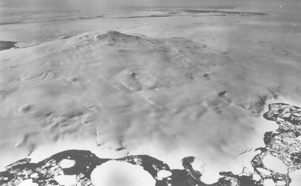
 Mount Siple forms the high point of Siple Island in Marie Byrd Land off the coast of Antarctica. This aerial view looks east, with dark-colored open water in the foreground and the Getz Ice Shelf between the island and Antarctica. Most volcanic features are buried in snow and ice, but the Lovill Bluff tuff cone outcrops at sea level (bottom right). Trachytic rocks at the summit have been Ar-Ar dated to about 227,000 and 169,000 years old.