Report on Semeru (Indonesia) — March 1995

Bulletin of the Global Volcanism Network, vol. 20, no. 3 (March 1995)
Managing Editor: Richard Wunderman.
Semeru (Indonesia) Ash eruptions, lava avalanches, and summit glow
Please cite this report as:
Global Volcanism Program, 1995. Report on Semeru (Indonesia) (Wunderman, R., ed.). Bulletin of the Global Volcanism Network, 20:3. Smithsonian Institution. https://doi.org/10.5479/si.GVP.BGVN199503-263300
Semeru
Indonesia
8.108°S, 112.922°E; summit elev. 3657 m
All times are local (unless otherwise noted)
Activity from the Jonggring Seloko summit crater continued in January and February 1995. Ash eruptions rose as high as 600 m above the summit. Lava avalanches increased in frequency during January and early February, and traveled down the Kembar River drainage to a distance of 750 m from the summit. Glow was sometimes observed 50-100 m above the summit. On the morning of 6 February three pyroclastic avalanches moved 800-1,000 m from the summit along the Kembar River before turning into the Kobokan River.
Tremor and volcanic earthquakes (both A- and B-type) were variable, with 20-110 events/day and 1-12 events/day, respectively (figure 5, top). Maximum tremor amplitude was 3-18 mm during the first week of January before increasing and peaking at 30 mm on the 8th. The daily number of explosions, recorded by a seismograph, showed an overall decline from 40-190 events/day in December to
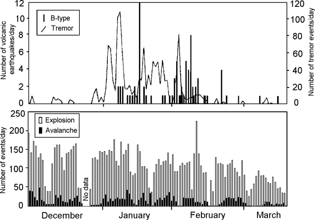 |
Figure 5. Tremor events and B-type volcanic earthquakes (top), and explosion and avalanche events detected by seismograph (bottom) at Semeru, December 1994-March 1995. Courtesy of VSI |
Geological Summary. Semeru, the highest volcano on Java, and one of its most active, lies at the southern end of a volcanic massif extending north to the Tengger caldera. The steep-sided volcano, also referred to as Mahameru (Great Mountain), rises above coastal plains to the south. Gunung Semeru was constructed south of the overlapping Ajek-ajek and Jambangan calderas. A line of lake-filled maars was constructed along a N-S trend cutting through the summit, and cinder cones and lava domes occupy the eastern and NE flanks. Summit topography is complicated by the shifting of craters from NW to SE. Frequent 19th and 20th century eruptions were dominated by small-to-moderate explosions from the summit crater, with occasional lava flows and larger explosive eruptions accompanied by pyroclastic flows that have reached the lower flanks of the volcano.
Information Contacts: W. Tjetjep, VSI.