Report on Kikai (Japan) — January 1999
Bulletin of the Global Volcanism Network, vol. 24, no. 1 (January 1999)
Managing Editor: Richard Wunderman.
Kikai (Japan) April 1998 ashfalls; ash eruptions during July-September
Please cite this report as:
Global Volcanism Program, 1999. Report on Kikai (Japan) (Wunderman, R., ed.). Bulletin of the Global Volcanism Network, 24:1. Smithsonian Institution. https://doi.org/10.5479/si.GVP.BGVN199901-282060
Kikai
Japan
30.793°N, 130.305°E; summit elev. 704 m
All times are local (unless otherwise noted)
During 25-27 April 1998 residents on Tokaro-Iwo-Jima Island reported minor ashfalls. A field inspection on 4-5 May by members of the Kagoshima Local Meteorological Office disclosed a 5-mm-deep ash deposit around the Iwodake Crater. This was interpreted to record a small-scale ash eruption. Around the time of the visit, earthquakes were at a level higher than usual.
Several to 10 earthquakes per day were recorded during July 1998, similar to levels in March. During 27-29 July, reddish-brown ash clouds were escaping from the summit crater and light ashfalls were reported at the village of Takeshima, 10 km to the E of the summit. Seismicity was lower in August, with generally less than 10 events/day recorded. Several light ashfalls occurred during August. In September, earthquake activity increased to 20-40 events per day, and there were several minor ashfalls.
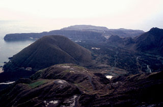
Geological Summary. Multiple eruption centers have exhibited recent activity at Kikai, a mostly submerged, 19-km-wide caldera near the northern end of the Ryukyu Islands south of Kyushu. It was the source of one of the world's largest Holocene eruptions about 6,300 years ago when rhyolitic pyroclastic flows traveled across the sea for a total distance of 100 km to southern Kyushu, and ashfall reached the northern Japanese island of Hokkaido. The eruption devastated southern and central Kyushu, which remained uninhabited for several centuries. Post-caldera eruptions formed Iodake (or Iwo-dake) lava dome and Inamuradake scoria cone, as well as submarine lava domes. Recorded eruptions have occurred at or near Satsuma-Iojima (also known as Tokara-Iojima), a small 3 x 6 km island forming part of the NW caldera rim. Showa-Iojima lava dome (also known as Iojima-Shinto), a small island 2 km E of Satsuma-Iojima, was formed during submarine eruptions in 1934 and 1935. Mild-to-moderate explosive eruptions have occurred during the past few decades from Iodake, a rhyolitic lava dome at the eastern end of Satsuma-Iojima.
Information Contacts: Yosihiro Sawada, Earthquake & Tsunami Observation Division, Seismology & Volcanology Dept., Japan Meteorological Agency, 1-3-4 Ote-machi, Chiyoda-ku, Tokyo 100-8122, Japan.