Report on Semeru (Indonesia) — July 2000

Bulletin of the Global Volcanism Network, vol. 25, no. 7 (July 2000)
Managing Editor: Richard Wunderman.
Semeru (Indonesia) Ongoing eruptive activity; 27 July explosion causes injuries and two fatalities
Please cite this report as:
Global Volcanism Program, 2000. Report on Semeru (Indonesia) (Wunderman, R., ed.). Bulletin of the Global Volcanism Network, 25:7. Smithsonian Institution. https://doi.org/10.5479/si.GVP.BGVN200007-263300
Semeru
Indonesia
8.108°S, 112.922°E; summit elev. 3657 m
All times are local (unless otherwise noted)
Semeru has been undergoing nearly constant eruptive activity since 1967. Volcanological Survey of Indonesia (VSI) reports through mid-September 1999 (BGVN 24:09) and earlier described seismicity (including seismically detected pyroclastic flows) and ongoing eruptive outbursts. Accessible Darwin VAAC reports since 3 June 1998 help to characterize the long-term eruptive patterns (table 3). VSI reports are not available for September 1999 through January 2000.
Table 3. A summary of aviation reports (Volcanic Ash Advisories) describing Semeru's plumes during 3 June 1998-21 August 2000. The first two columns describe the time and date when a report was issued. Time entries with commas signify that multiple reports were generated with similar comments. Where available, the time of the observations appear with the comment. Dash marks indicate lack of mention in report. Note that for plume heights, Semeru's summit lies at 3,676 m above sea level. Information sources include air reports (for example, routed via airlines, AIREPS), pilot reports (PIREPS), Notice to Airmen (NOTAM), satellite data, and reports from ground observations. Source data was provided by the Darwin VAAC.
| Date | Time (GMT) | Information Sources | Plume altitude (km) | Satellite confirmed ash (Y/N) | Clouds (Y/N) | Comment |
| 03 Jun 1998 | 0525 | AIREP | -- | N | -- | Volcanic activity observed S of Surabaya, cloud moving S. |
| 11 Jul 1998 | 0635 | AIREP | 6.1 | -- | -- | Small volcanic plume. |
| 31 Aug 1998 | 0635 | AIREP | 6.1 | -- | -- | Small ash plume. |
| 01 Sep 1998 | 1500 | AIREP | 7.6 | N | -- | Volcanic activity observed at 1037. |
| 02 Sep 1998 | 0800 | AIREP | 5.2 | N | -- | Volcanic activity observed at 0551. |
| 19 Apr 1999 | 1228 | AIREP | 7.6 | N | -- | Eruption observed at 1003. |
| 13 Jun 1999 | 1003 | AIREP | 6.1 | N | -- | Plume tops seen. |
| 09 Jul 1999 | 0942 | NOTAM | 6.1 | N | -- | Report of ash cloud. |
| 16 Jul 1999 | 1226 | AIREP | 4.6 | Y | -- | Eruption reported at 0905. Weak ash plume apparent on satellite imagery extending 16.7 km WSW at 0936; no ash apparent on subsequent lower resolution imagery at 1030 and 1130. |
| 16 Jul 1999 | 1817 | AIREP | -- | N | -- | Satellite imagery shows no further evidence of ash cloud at 1732. |
| 05 Aug 1999 | 0451 | AIREP | 6.1 | N | -- | Reported plume at 0350; satellite imagery at 0232 showed no evidence of ash cloud. |
| 05 Aug 1999 | 0538 | AIREP | 6.1 | N | Y | Follow-up to plume (reported above). |
| 23 Aug 1999 | 0304 | NOTAM | 4.6 (top) | N | N | Volcanic ash drifting SW; satellite image at 0132 and last 3 hourly images (no plume visible). |
| 13 Jun 2000 | 1144 | AIREP | 7.6 | N | -- | Ash plume. |
| 13 Jun 2000 | 1211 | AIREP | 7.6 | N | -- | Ash plume. |
| 23 Jun 2000 | 1228 | AIREP | 4.6 | N | -- | Ash plume at 0445. |
| 16 Jul 2000 | 1128 | AIREP | 7.6 | N | -- | Ash cloud at 0335. |
| 18 Jul 2000 | 0946 | AIREP | 9.2 | N | -- | Ash cloud 0600. |
| 18 Jul 2000 | 1536, 2129 | AIREP | -- | N | -- | Ash cloud follow-up but cloud appears to have dissipated. |
| 19 Jul 2000 | 0044 | NOAA | 9.2 | Y | -- | Satellite imagery at 2115 and 2330; ash extending 56 km WSW bearing 257° from Mt. Semeru, plume width not more than 11 km; winds in area suggest height of ash above 5.5 km. |
| 19 Jul 2000 | 0652, 1245, 1837 | GMS-5 satellite and Meteorological & Geophysical Agency of Indonesia | 4.6-9.2 | -- | -- | Apparently undergoing a phase of enhanced activity; ground based reports over last month have given plume heights of 4.6 km; no ash clouds observed by satellite since 0030. |
| 20 Jul 2000 | 0019 | GMS-5 satellite and Meteorological & Geophysical Agency of Indonesia | -- | N | -- | Latest imagery at 2333 on 19 July. |
| 19 Aug 2000 | 0653, 0812 | PIREP | 10.7 | N | Y | Possible smoke plume at 0438; scattered cloud in area. |
| 20 Aug 2000 | 0944 | AIREP | 7.3 | Y | N | Smoke plume at 0427; satellite imagery mostly clear of cloud shows a weak plume extending SSE 56-74 km. |
| 21 Aug 2000 | 0938 | -- | -- | N | -- | Satellite imagery lacks clear plume at 0830. |
Activity during February-July 2000. Explosive activity during February 2000 included ash emissions, numerous rockfalls, and a few deep A-type earthquakes (table 4). Plumes of thick white ash were seen to rise up to 400 m above the summit on many occasions. Persistent haze or cloudy weather prevented direct observation throughout most of the month. At night during the week of 8-14 February observers noted a 60-m-high flame. Generally, explosions and rockfalls dominated recorded seismicity.
Table 4. Summary of seismicity at Semeru, 31 January-29 August 2000. * Six days of data, through 15 July. Courtesy of VSI.
| Dates | Deep (A-type) | Shallow (B-type) | Tectonic | Explosion | Avalanche | Tremor | Pyroclastic Flows |
| 31 Jan-07 Feb 2000 | 2 | 3 | 6 | 142 | 49 | 4 | -- |
| 08 Feb-14 Feb 2000 | 2 | -- | 9 | 390 | 5 | 31 | -- |
| 15 Feb-21 Feb 2000 | 8 | -- | 3 | 327 | 9 | 0 | -- |
| 22 Feb-27 Feb 2000 | 1 | -- | 4 | 548 | 11 | -- | -- |
| 29 Feb-07 Mar 2000 | "Seismic activity was relatively similar to last week... dominated by explosion and avalanche earthquakes." | ||||||
| 07 Mar-13 Mar 2000 | 19 | 5 | 5 | 628 | 38 | -- | 1 |
| 14 Mar-20 Mar 2000 | 3 | -- | 15 | 530 | 18 | -- | -- |
| 21 Mar-27 Mar 2000 | 5 | 4 | 8 | 733 | 26 | -- | -- |
| 28 Mar-03 Apr 2000 | 5 | 4 | 8 | 733 | 26 | 16 | -- |
| 04 Apr-10 Apr 2000 | 8 | -- | 7 | 737 | 45 | 56 | 1 |
| 11 Apr-17 Apr 2000 | 1 | -- | 3 | 805 | 50 | 18 | -- |
| 18 Apr-24 Apr 2000 | -- | 1 | 4 | 678 | 45 | 48 | -- |
| 25 Apr-01 May 2000 | 2 | -- | 4 | 703 | 31 | 17 | 3 |
| 02 May-08 May 2000 | -- | 13 | 3 | 770 | 46 | -- | 5 |
| 09 May-16 May 2000 | -- | -- | 2 | 535 | 15 | -- | 4 |
| 17 May-23 May 2000 | 7 | 3 | 1 | 705 | 95 | -- | 3 |
| 24 May-30 May 2000 | No data available. | ||||||
| 31 May-05 Jun 2000 | No data available. | ||||||
| 06 Jun-12 Jun 2000 | No data available. | ||||||
| 13 Jun-19 Jun 2000 | -- | -- | 7 | 557 | 25 | 7 | 2 |
| 20 Jun-26 Jun 2000 | 1 | 1 | 4 | 709 | 56 | 4 | -- |
| 27 Jun-02 Jul 2000 | -- | 1 | 6 | 600 | 86 | 15 | 6 |
| 03 Jul-09 Jul 2000 | 1 | -- | 6 | 717 | 36 | 9 | 8 |
| 10 Jul-15 Jul 2000* | -- | 1 | 6 | 557 | 27 | 6 | 8 |
| 17 Jul-23 Jul 2000 | No data available. | ||||||
| 24 Jul-30 Jul 2000 | 14 | 4 | 18 | 542 | 60 | -- | 7 |
| 31 Jul-07 Aug 2000 | -- | -- | -- | 657 | 64 | -- | 5 |
| 08 Aug-14 Aug 2000 | -- | -- | -- | 584 | 43 | -- | 2 |
| 15 Aug-21 Aug 2000 | -- | -- | -- | 420 | 17 | -- | 0 |
| 22 Aug-29 Aug 2000 | 23 | 1 | 21 | 542 | 27 | -- | 3 |
Explosions and lava avalanches continued in March. Clouds and haze often obscured the volcano, but sometimes thick white emissions appeared above the summit to a maximum height of 500 m. Visual activity and seismicity appeared to increase in late March-early April.
During 4-10 April explosions and lava avalanches were still continuing and became stronger. Seismicity also increased significantly; tremor earthquakes took place 56 times, with maximum amplitudes of 3-15 mm. One pyroclastic flow traveled 1,500 m down the Besuk Kembar river. Many observations in clear conditions showed that the ash cloud was thick and white, rising 400-600 m above the summit. Emissions continued the following week, and explosions increased. "Red flames" sometimes appeared at the summit during night observations. Similar activity continued throughout April. The number of pyroclastic flows increased in late April, and continued at a typical rate of 2-7 per week for the next few months (table 4). On 30 April at 0743, from a location 15 km NNW of Semeru, a pyroclastic flow was observed travelling 800 m down the SSW flank.
Ashfall occurred at the Semeru Volcano Observatory during the week of 2-8 May, when five pyroclastic flows were recorded. Seismicity decreased again, but "red flame" was still seen at night and plumes rose as high as 600 m through 23 May.
Explosive activity was continuing in the second half of June; observers noted white-gray plumes ~600 m above the summit. Pyroclastic flows that reached maximum distances of ~2.5-3 km were reported on 1-2, 4, 10, and 15 July.
Observations on 2 May 2000. John Seach and Geoff Mackley made observations during a 3-hour summit stay on 2 May 2000. During the climb from Ranu Pani village in the N, ash deposits were observed to cover vegetation at a distance of 10 km from the volcano. The bottom third of the cone was vegetated, and zones of mass-wasting had sliced away 20- m-wide sections of forest. The top two-thirds of the cone consisted of ash, cinders, and blocks up to 1.5 m in diameter. There were areas of deep erosion and the risk of rockfalls posed a hazard to climbers.
The summit area (Mahameru) lay covered by ash and baseball-sized blocks with a density of 50/m2. A 20-m-wide, 60-m-deep, W-sloping valley separated Mahameru from the active Jonggring Seloko crater, but they are joined by a ridge. The highest N rim of the crater was approximately 30 m below the summit peak. A 2-m-diameter block was located 15 m below the summit on the wall of the valley.
Between 0725 and 1010, 13 eruptive events were observed. During this interval the N rim of Jonggring could not be approached because of the intermittent rain of blocks falling outside the crater and into the valley 50 m from the crater. Two vents produced short-lived Vulcanian eruptions with variable timing and size. Eruptions commenced with degassing, explosions, or the sound of breaking rock, followed by falling bombs and brown ash emission. The explosions were relatively quiet and not accompanied by groundshaking. Brown ash clouds rose to 600 m above the vent and drifted SE. The plume detached from the summit before the next eruption began. Steam emission occurred between eruptions.
Observations on 14 July 2000. Volcanologists on an International Association of Volcanology and Chemistry of the Earth's Interior (IAVCEI) field trip in east Java observed eruptions of Semeru from an observation point on the N rim of the Sand Sea caldera at Bromo (figure 10). Eruption plumes became visible just before sunrise. Gray ash-and-steam plumes rose a few hundred meters and drifted out over the ocean. Multiple plumes from earlier eruptions were visible downwind. Eruptions lasted up to 2 minutes, and occurred at intervals of between 5 and 30 minutes during the approximately 2 hours of observations. One explosion event was quickly followed by another explosion, apparently from a second location within the crater. Plumes were frequently seen during the next two days from other points around the volcano.
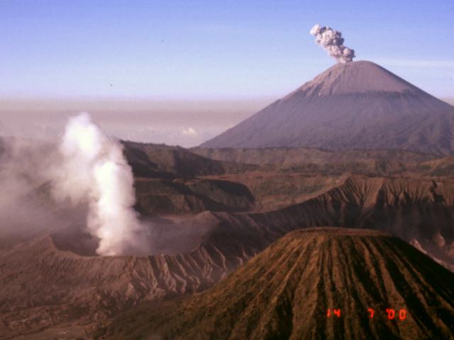 |
Figure 10. Photograph taken just after sunrise on 14 July 2000 showing an ash eruption from Semeru (upper right) and a steam plume rising from Bromo (lower left). The cone in the lower right is Batok, another young cone within the Sand Sea caldera of the Bromo-Tengger volcanic complex. Note the extensive ash cover on the upper part of Semeru. View is towards the S. Courtesy of Ed Venzke, Smithsonian Institution. |
Explosion on 27 July 2000. At approximately 0706 on the morning of 27 July an explosion resulted in two deaths and injuries to five other volcanologists near the NE rim of the active summit crater Jonggring Seloko (see map in BGVN 17:10). The group consisted of a five-member Semeru evaluation team of the Volcanological Survey of Indonesia (VSI), four local porters, and foreign scientists who had attended the IAVCEI conference in Bali the previous week. The fatalities and injuries were caused by impacts and burns from ballistic clasts. These originated from the second of two closely spaced explosions from separate vents that ejected material out to a few hundred meters. Both fatalities were VSI staff members: Asep Wildan was the team leader, and Mukti was a volcano observer from the Semeru Volcano Observatory. Those injured included Suparno, a VSI volcano observer from the Semeru Volcano Observatory, Amit Mushkin from the Hebrew University in Israel, Mike Ramsey from the University of Pittsburgh, and Lee Siebert and Paul Kimberly from the Smithsonian Institution. Kimberly sustained the most serious injuries among the five survivors, including a broken hand, broken arm, and 3rd-degree burns. Following surgeries in Singapore and burn treatments in the United States, Kimberly was released from the hospital in early September.
Continuing activity through August. Visual observations were hindered by bad weather the first week of August. Activity generally decreased through 22 August. White to light-brown ash clouds rising to about 600 m in height were frequently seen during this period. Seismicity increased again in late August, and on 25 and 27 August three pyroclastic flows were recorded. Thin white-gray ash plumes rose ~600 m.
Geological Summary. Semeru, the highest volcano on Java, and one of its most active, lies at the southern end of a volcanic massif extending north to the Tengger caldera. The steep-sided volcano, also referred to as Mahameru (Great Mountain), rises above coastal plains to the south. Gunung Semeru was constructed south of the overlapping Ajek-ajek and Jambangan calderas. A line of lake-filled maars was constructed along a N-S trend cutting through the summit, and cinder cones and lava domes occupy the eastern and NE flanks. Summit topography is complicated by the shifting of craters from NW to SE. Frequent 19th and 20th century eruptions were dominated by small-to-moderate explosions from the summit crater, with occasional lava flows and larger explosive eruptions accompanied by pyroclastic flows that have reached the lower flanks of the volcano.
Information Contacts: Volcanological Survey of Indonesia (VSI), Jalan Diponegoro No. 57, Bandung 40122, Indonesia (URL: http://www.vsi.esdm.go.id/); Darwin Volcanic Ash Advisory Centre (VAAC), Bureau of Meteorology, Northern Territory Regional Office, PO Box 40050, Casuarina, NT 0811, Australia (URL: http://www.bom.gov.au/info/vaac/); John Seach, P.O. Box 16, Chatsworth Island, NSW 2469, Australia; Ed Venzke, Global Volcanism Program, Smithsonian Institution, Washington DC 20560-0119, USA.