Report on Semeru (Indonesia) — April 2003

Bulletin of the Global Volcanism Network, vol. 28, no. 4 (April 2003)
Managing Editor: Edward Venzke.
Semeru (Indonesia) Continued ash explosions, with frequent lava avalanches and pyroclastic flows
Please cite this report as:
Global Volcanism Program, 2003. Report on Semeru (Indonesia) (Venzke, E., ed.). Bulletin of the Global Volcanism Network, 28:4. Smithsonian Institution. https://doi.org/10.5479/si.GVP.BGVN200304-263300
Semeru
Indonesia
8.108°S, 112.922°E; summit elev. 3657 m
All times are local (unless otherwise noted)
At Semeru, the end of December 2002 was characterized by high numbers of explosions and pyroclastic flows (BGVN 27:12). The 29 December pyroclastic flow at Besuk Bang (figures 11 and 12) traveled ~9 km from the summit. During January through 23 March 2003, the Volcanological Survey of Indonesia (VSI) reported that seismicity was dominated by explosions and avalanches (table 11). A "white-gray ash" column rose 300-700 m above the summit. Activity was especially high during 1-12 January, when tens of ash explosions were visually observed per week (figures 13 and 14). Continuous tremor occurred on 8 January, with an amplitude of 11-12 mm. The Alert level remained at 2.
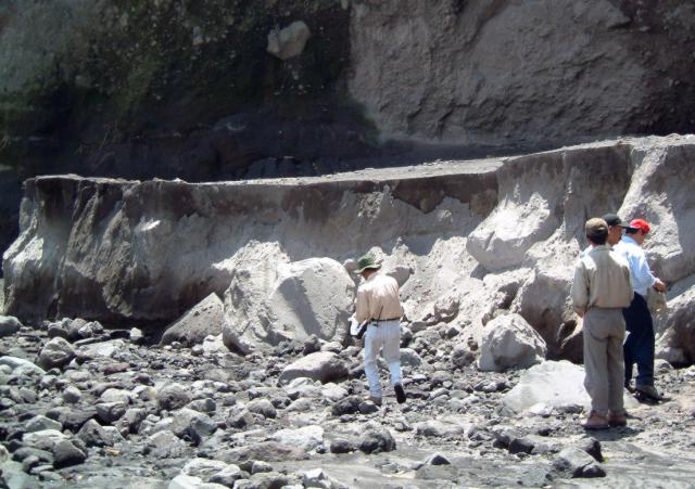 |
Figure 11. The edge of 29 December 2002 Semeru pyroclastic-flow deposit at Besuk Bang in January 2003. This pyroclastic flow extended ~ 9 km from the summit. Courtesy of I. Mulyana, H. Triastuty, M. Hendrasto, and MA Purbawinata (VSI). |
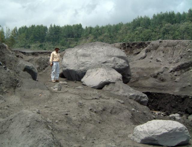 |
Figure 12. Boulders from the Semeru pyroclastic-flow deposit at Besuk Bang around December 2002-January 2003. Courtesy of I. Mulyana, H. Triastuty, M. Hendrasto, and MA Purbawinata (VSI). |
Table 11. Summary of weekly seismicity at Semeru during 1 January-23 March 2003. Courtesy VSI.
| Date | Deep volcanic (A-type) | Shallow volcanic (B-type) | Explosions | Avalanches | Tremor earthquakes | Pyroclastic flows |
| 01 Jan-05 Jan 2003 | -- | 4 | 354 | 89 | 7 | 0 |
| 06 Jan-12 Jan 2003 | -- | -- | 382 | 84 | 38 | 1 |
| 13 Jan-19 Jan 2003 | -- | 1 | 554 | 89 | 7 | 0 |
| 20 Jan-26 Jan 2003 | 1 | 2 | 641 | 50 | 15 | 0 |
| 27 Jan-02 Feb 2003 | 18 | -- | 739 | 84 | 9 | 3 |
| 03 Feb-09 Feb 2003 | 2 | -- | 777 | 58 | 9 | 14 |
| 10 Feb-16 Feb 2003 | 3 | 4 | 641 | 53 | 13 | 5 |
| 17 Feb-23 Feb 2003 | 4 | 9 | 700 | 105 | 10 | 9 |
| 24 Feb-02 Mar 2003 | 6 | -- | 629 | 33 | 8 | 10 |
| 03 Mar-09 Mar 2003 | -- | 4 | 794 | 18 | 4 | 0 |
| 10 Mar-16 Mar 2003 | 2 | -- | 550 | 89 | 20 | 21 |
| 17 Mar-23 Mar 2003 | -- | -- | 563 | 57 | 9 | 13 |
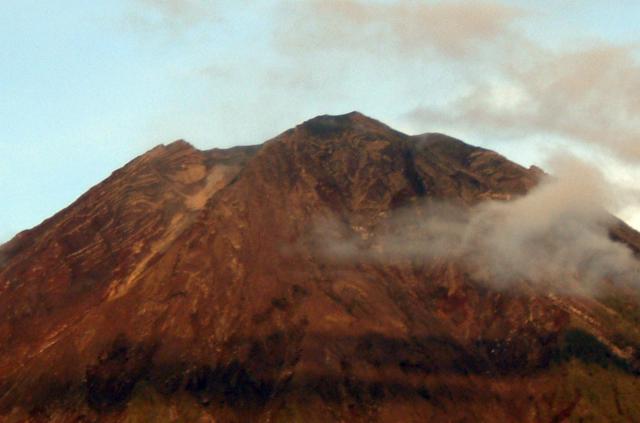 |
Figure 13. View toward the summit of Semeru looking NW from G. Sawur (observatory post) around December 2002-January 2003. Courtesy of I. Mulyana, H. Triastuty, M. Hendrasto, and MA Purbawinata (VSI). |
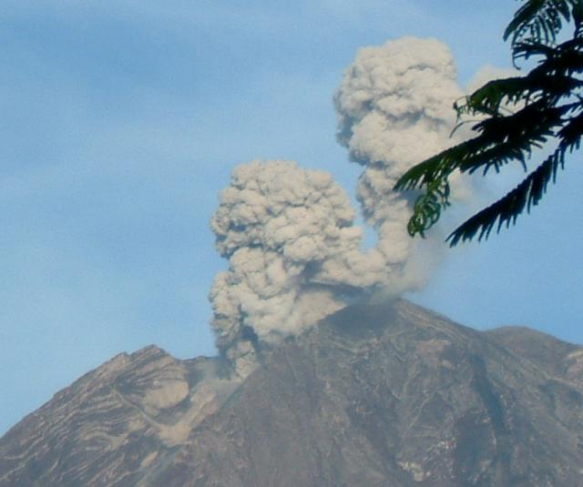 |
Figure 14. Eruptive plumes rise from two different vents at the summit of Semeru around December 2002-January 2003. Courtesy of I. Mulyana, H. Triastuty, M. Hendrasto, and MA Purbawinata (VSI). |
Lava avalanches in January 2003 extended up to 750 m from the crater rim and sometimes entered the Besuk Kembar river. One pyroclastic flow traveled 1,500 m and also entered Besuk Kembar. Pyroclastic flows were more numerous in February, travelling between 2.5 and 4 km from the summit into the Besuk Bang drainage. Lava avalanches were continuous during 17-23 February towards Besuk Kambar. Several pyroclastic flows in March moved toward Besuk Bang (up to 4 km long) and Besuk Kembar (up to 2 km long).
Infrared satellite data, January 2001-March 2003. Between January 2001 and March 2003, MODIS detected quasi-continuous thermal alerts at Semeru (figure 15). During January 2001-March 2002, the anomalies were characterized by 1-2 alert-pixels with a maximum alert ratio of -0.567 (4 May 2001). The Darwin VAAC reported ash plumes and clouds on several occasions throughout this period, and VSI reported numerous seismic events representing explosions and other phenomena (BGVN 26:08).
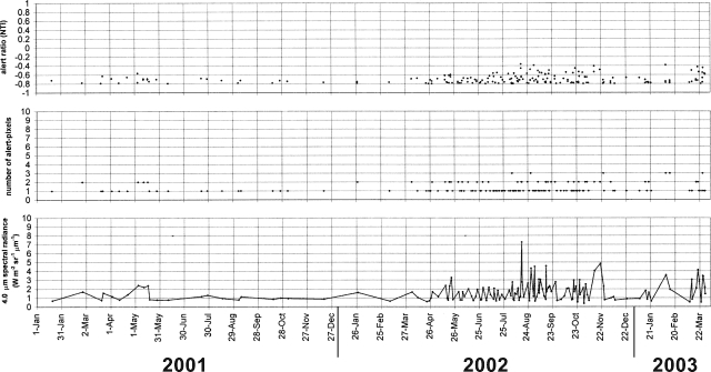 |
Figure 15. MODIS thermal alerts on Semeru during January 2001-March 2003. Thermal alerts collated by Diego Coppola and David Rothery; data courtesy of the Hawaii Institute of Geophysics and Planetology's MODIS Thermal Alert Team. |
From April 2002 until the end of the year, MODIS thermal alerts for Semeru increased in frequency and magnitude. This period was characterized by continuous explosions, avalanches and pyroclastic flows, and is related to seismicity increases beginning in March 2002 that prompted VSI to raise the Alert Level to 2 (BGVN 27:06). Thermal alerts reached a maximum amplitude on 16 August (two alert pixels with a maximum alert ratio of -0.364) and 1 September (one alert pixel with alert ratio of -0.389). VSI reported that seismic activity was higher than normal during June-September 2002 (BGVN 27:09), and the explosions produced plumes that reached 300-500 m above the crater. Observers reported that lava avalanches traveled toward the Besuk Kembar river to distances of ~750 m from the crater rim, and an ash explosion ejected glowing material ~150 m toward the upper Besuk Kembar drainage. Center coordinates of alert pixels were concentrated in four adjacent pixels close to Semeru's summit, especially on the S side.
Geological Summary. Semeru, the highest volcano on Java, and one of its most active, lies at the southern end of a volcanic massif extending north to the Tengger caldera. The steep-sided volcano, also referred to as Mahameru (Great Mountain), rises above coastal plains to the south. Gunung Semeru was constructed south of the overlapping Ajek-ajek and Jambangan calderas. A line of lake-filled maars was constructed along a N-S trend cutting through the summit, and cinder cones and lava domes occupy the eastern and NE flanks. Summit topography is complicated by the shifting of craters from NW to SE. Frequent 19th and 20th century eruptions were dominated by small-to-moderate explosions from the summit crater, with occasional lava flows and larger explosive eruptions accompanied by pyroclastic flows that have reached the lower flanks of the volcano.
Information Contacts: Dali Ahmad, Volcanological Survey of Indonesia (VSI), Jalan Diponegoro No. 57, Bandung 40122, Indonesia (URL: http://www.vsi.esdm.go.id/); Diego Coppola and David A. Rothery, Department of Earth Sciences, The Open University, Milton Keynes, MK7 6AA, UK. Thermal alerts courtesy of the HIGP MODIS Thermal Alerts Team (URL: http://modis.higp.hawaii.edu/).