Report on Ritter Island (Papua New Guinea) — May 2007
Bulletin of the Global Volcanism Network, vol. 32, no. 5 (May 2007)
Managing Editor: Edward Venzke.
Ritter Island (Papua New Guinea) Eruption on 19 May causes landslides and sea surges
Please cite this report as:
Global Volcanism Program, 2007. Report on Ritter Island (Papua New Guinea) (Venzke, E., ed.). Bulletin of the Global Volcanism Network, 32:5. Smithsonian Institution. https://doi.org/10.5479/si.GVP.BGVN200705-251070
Ritter Island
Papua New Guinea
5.519°S, 148.115°E; summit elev. 75 m
All times are local (unless otherwise noted)
On 17 October 2006 occasional small earthquakes on Ritter Island were followed by emissions of white vapor and diffuse ash clouds, occasional rock slides from the inner crater wall, and ashfall on nearby Umboi (Siassi) Island (BGVN 32:03). No further activity was reported until 19 May 2007, when sea surges destroyed a boat and four houses on Umboi following an eruption, according to media quotes from Morobe Province disaster and emergency director Roy Kamen. Kamen also noted that 1,500-2,000 people from two villages had moved to higher ground for fear of tsunamis. As of 21 May residents could still hear rumbling noises, see "smoke" rising from Ritter Island, and feel tremors. The Rabaul Volcanological Observatory (RVO) and the Geophysical Observatory in Port Moresby did not record seismic activity from the eruption on their equipment.
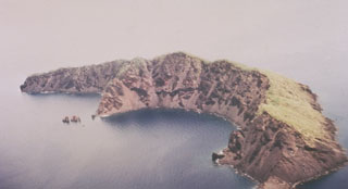
Reports received by RVO from Jonathan Kuduon at Kilenge (western New Britain) on 30 May indicated evidence of high waves (4-10 m high) around Ritter Island, with a maximum of 10 m on the S part of the island. Scorched vegetation was seen in the same area, and dead marine animals, mainly reef fish, were seen around the coastline. There was no evidence of fresh volcanic material, but a new landslide scar was visible on the S tip of island, an area that extended from the uppermost part of the island (~100 m elevation) down to sea level. Several other small landslide scars were seen on the W wall. Rockfalls continued to produce clouds that could be seen from a distance. Seismic activity was low during one day of recording on 27-28 May; only four high-frequency earthquakes were recorded.
RVO noted that the event on 19 May was similar to the 1972 and 1974 events, in that they lasted only a few hours and were preceded by explosion noises followed by disturbance of the sea. Both the 1972 and 1974 activities occurred offshore, and landslides were triggered during the 1974 activity. The 19 May event may have been due submarine explosions or earthquakes associated with volcanic activity that triggered the landslide(s).
Geological Summary. Prior to 1888, Ritter Island was a steep-sided, nearly circular island about 780 m high between Umboi and Sakar Islands. Several historical explosive eruptions had been recorded prior to 1888, when large-scale slope failure destroyed the summit of the conical basaltic-andesitic volcano, leaving the arcuate 140-m-high island with a steep west-facing scarp. Devastating tsunamis were produced by the collapse and swept the coast of Papua New Guinea and offshore islands. Two minor post-collapse explosive eruptions, during 1972 and 1974, occurred offshore within the largely submarine 3.5 x 4.5 km breached depression formed by the collapse.
Information Contacts: Herman Patia, Rabaul Volcanological Observatory (RVO), Department of Mining, Private Mail Bag, Port Moresby Post Office, National Capitol District, Papua New Guinea; Australian Associated Press, AAP News Centre, 3 Rider Boulevard, Rhodes Waterside, Rhodes, NSW 2138, Australia (URL: http://aap.com.au/).