On 30 May, RVO reported observations of Ritter Island following reports of a possible eruption and "sea surges" that destroyed homes on 19 May. On the S part of the island, scorched vegetation was observed and dead marine life (mainly reef fish) was seen around the coast line at heights of 4-6 m a.s.l. There was no evidence of fresh volcanic material, but a new landslide scar extended from the upper most part of the island down to sea level. Several more landslide scars were seen on the W wall. The estimated wave surge height resulting from the 19 May event reached 4-10 m, particularly around the S part of the island. Rockfalls continued to produce plumes that could be seen from a distance.
Source: Rabaul Volcano Observatory (RVO)
Report includes past geothermal activity observations
According to the Rabaul Volcanological Observatory, a "small (probably submarine) eruption was reported to have taken place at Ritter Island on 18 April 2014 (figures 2 and 3). At about 1700 hours, an earthquake was felt at Kampalap village on Umboi Island. At the same time the level of sea rose a little over normal but was confined to the beach at Kampalap. At around 0000 hours on 19 April, another felt earthquake occurred. The earthquakes were estimated to have an intensity at Kampalap of between II to III. No floating debris where seen, and no ash or damage was reported."
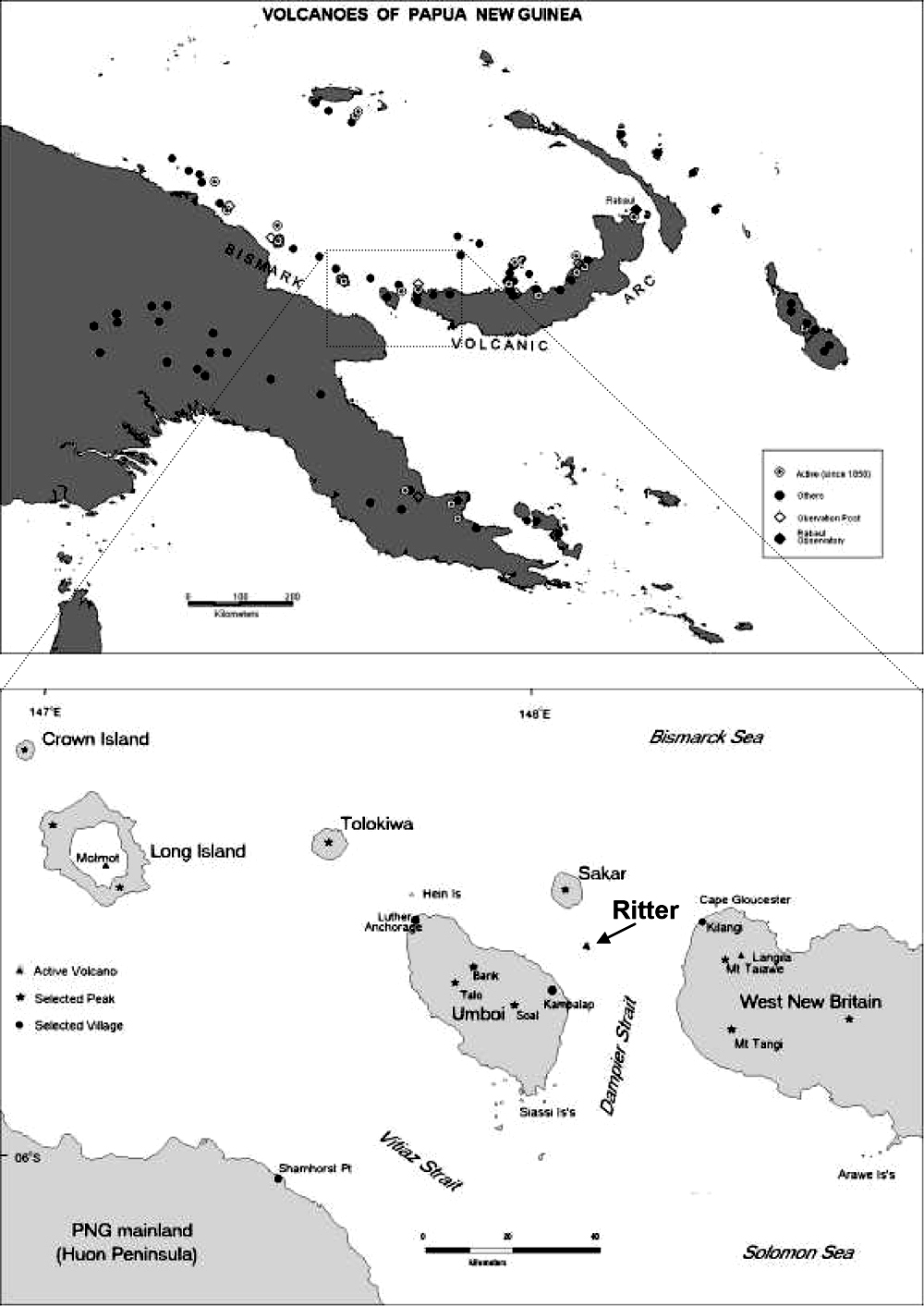 |
Figure 2. Location maps for Ritter Island. The upper map shows the region of Papua New Guinea containing Ritter Island and other volcanoes, and the lower map is enlargement of the center of the upper map focused on Ritter Island. From Saunders and Kuduon (2009). |
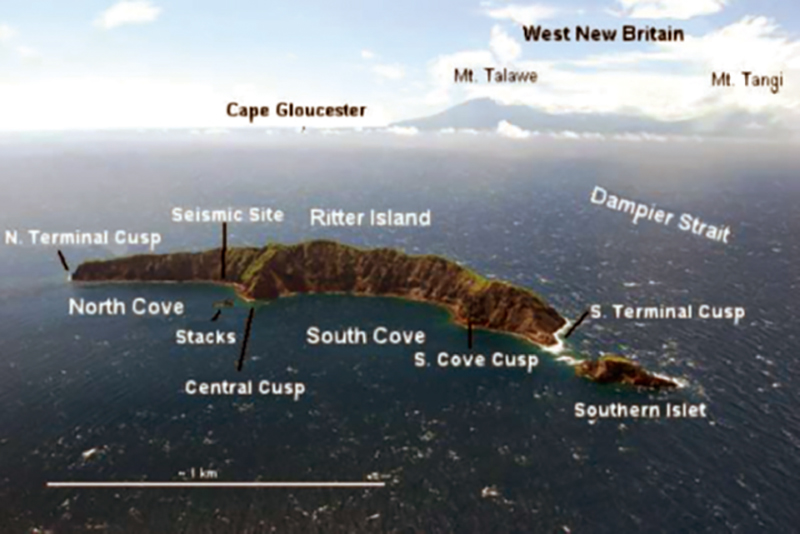 |
Figure 3. Oblique aerial view of Ritter Island photographed in 2006 by John Holder (the originator of Oceanic Expeditions) from SW looking NE, with some of the location names. From Saunders and Kuduon (2009). |
A Rabaul Volcanological Observatory (RVO) report by Saunder and Kuduon (2009) noted past possible geothermal activity on Ritter Island that had not been previously reported. According to their report, "In 1997 a patrol officer (Hita Mesere) in a media release relayed reports from Councilor Nalong (Kampalap Village?) of an explosive eruption and large waves reaching nearby villages. In the preparation of this report Mr. Mesere was contacted and he confirmed that he and officers from the Morobe PDO flew over Ritter after this event and saw white smoke coming from 'boiling' in the sea, close to land in the South Bay (Mesere, 2009 Pers. Comm.)."
The report concluded that "Ritter is active, both volcanically and geomorphologically. More volcanic activity can be expected. Seismically this will probably not be as intense as in the early 1970's, as the conduit seems now to be open. Volcanic phenomena may however increase in importance if the cone continues to grow towards the surface and magma is erupted into an environment of lower hydrostatic pressures. There seems to be two causes of eruptive activity, one is the rise of fresh magma at the site of the submarine cone and the other is slope instability causing water to come into contact with residual hot rocks leading to small hydrovolcanian events close inshore of Ritter."
The RVO report also included the following table (table 1) showing past observations of possible geothermal activity on Ritter Island.
Table 1. Dates and details of reported post-collapse activity at Ritter. From of Saunders and Kuduon (2009).
| Date | Seismic Intensity | Explosions reported | White steam reported | Dust/Dark material reported | Sound reported | Location of emission |
| 9 Oct. 1972 | Felt 35 km away; regionally recorded | Multiple | Y | Y | Strong rumbling | Inshore W (S Cove) & off terminal cusps |
| 17 Oct. 1974 | Felt 30 km away: recorded in PNG | Multiple | Y | Y | N | Offshore ~1 km W |
| 19 Oct. 1996? (Pilot report only) | None reported | N | Y | N | N | ? |
| 1997 | None reported | Single or few | Y | N | N | Inshore W (S Cove) |
| 17 Oct. 2006 | Few small, locally felt | N | Y | Y | N | Offshore ~1 km W |
| 19 May 2007 | None reported | Several | Y | Y (and flames) | Rumbling & 3 explosions | Offshore ~1 km W |
Tsunami of 1888. Several recent papers have revisited the 13 March 1888 collapse of Ritter Island volcano that generated a catastrophic tsunami. According to Ward and Day (2003), "In the early morning of 1888 March 13, roughly 5 km3 of Ritter Island Volcano fell violently into the sea northeast of New Guinea. This event, the largest lateral collapse of an island volcano to be recorded in historical time, flung devastating tsunami tens of meters high on to adjacent shores. Several hundred kilometers away, observers on New Guinea chronicled 3 min period waves up to 8 m high, that lasted for as long as 3 h. These accounts represent the best available first-hand information on tsunami generated by a major volcano lateral collapse." Eyewitness accounts noted the lack of explosive activity accompanying the collapse. In this paper, the authors simulated the Ritter Island landslide as constrained by a 1985 sonar survey of its debris field and compare predicted tsunami with historical observations.
Ray and others (2014) reported that, based on primary and secondary eyewitness accounts on the morning of 13 March 1888 "there is no clear evidence for a coincident [to the collapse] or causal magmatic explosive eruption. One report suggests that there was activity (perhaps phreatic or phreatomagmatic explosions?) prior to the collapse that lead some of the resident local communities to seek higher ground, but evidence for precursory flank movements or changes in eruptive style have not been found in the historical accounts."
References. Ray, M.J., Day, S., and Downes, H., 2014, The growth of Ritter Island volcano, Papua New Guinea, and the lateral collapse landslide and tsunami of 1888: new insights from eyewitness accounts, EGU General Assembly 2014, Geophysical Research Abstracts, v. 16, EGU2014-1305.
Saunders, S., and Kuduon, J., 2009, The June 2009 Investigation Of Ritter Volcano, With A Brief Discussion On Its Current Nature, Rabaul Volcanological Observatory Open File Report OFP 003/2009, 25 pp.
Ward, S.N., and Day, S. 2003. Ritter Island—lateral collapse and the tsunami of 1888. Geophysics Journal International, v. 154, pp. 891-902.
Information Contacts: Rabaul Volcanological Observatory, P.O. Box 386, Rabaul, Papua New Guinea.
2007: May
2006: November
2002: July
On 30 May, RVO reported observations of Ritter Island following reports of a possible eruption and "sea surges" that destroyed homes on 19 May. On the S part of the island, scorched vegetation was observed and dead marine life (mainly reef fish) was seen around the coast line at heights of 4-6 m a.s.l. There was no evidence of fresh volcanic material, but a new landslide scar extended from the upper most part of the island down to sea level. Several more landslide scars were seen on the W wall. The estimated wave surge height resulting from the 19 May event reached 4-10 m, particularly around the S part of the island. Rockfalls continued to produce plumes that could be seen from a distance.
Source: Rabaul Volcano Observatory (RVO)
According to a news article, "sea surges" destroyed four homes and a boat following an eruption of Ritter Island on 19 May. About 1,500-2,000 people on Siassi Island moved to higher ground. Villagers reported seeing plumes from the island, hearing rumbling noises, and feeling earthquakes. The article also mentioned that RVO and the Geophysical Observatory in Port Moresby did not record any seismic activity from the eruption.
Source: Australian Associated Press
On 17 October, a villager from Kampalap (on the E coast of Siassi Island) reported unusual activity from Ritter Island to the RVO. The activity consisted of small felt earthquakes followed by emissions of white vapor and diffuse ash clouds. Rocks slid down the inner crater wall. Ashfall, which the observer indicated was not from Langila, was reported in Kampalap.
Source: Rabaul Volcano Observatory (RVO)
Qantas Airlines reported to the Darwin VAAC that an ash cloud to about ~3 km a.s.l. was observed on 2 August at 1450. Analysis of satellite data did not show ash.
Source: Darwin Volcanic Ash Advisory Centre (VAAC)
Reports are organized chronologically and indexed below by Month/Year (Publication Volume:Number), and include a one-line summary. Click on the index link or scroll down to read the reports.
Unusual earthquake swarm on 8 October from submarine eruption
Card 1496 (24 November 1972) Unusual earthquake swarm on 8 October from submarine eruption
Stations of the Papua New Guinea seismograph networks and high-gain central Australian stations recorded a swarm of unusual earthquakes on 8 October during the period 1930 to 2130 UTC. The magnitude (ML) of the shocks did not exceed 4.3 and there were at least 15 events with magnitude roughly 4.0. During the period 1945-2048 the seismic events were so numerous that there effects could not be distinguished. However near the start and finish of the swarm it was possible to recognize several separate events on PMG, LAT, WAB, and TLS seismograms, and arrival times of the seismic phases from those events indicated that the source of the shock was in the immediate proximity of the Ritter Island volcano. The effects of events recorded on seismograms were unlike those from tectonic shocks because of the long duration of the seismic waves and their long-period content. The Ritter Island area was inspected by A. Davies of the Rabaul Volcanological Observatory, who found that during the period of seismic activity submarine eruptions or explosions were observed close to Ritter Island. The vibrations from explosions caused landslides on Ritter Island and were felt with intensities of up to MM 4 at about 10 km from Ritter Island. The macroseismic data and the fact that there were relatively long-period waves in the seismic wave trains indicated a shallow source for the seismic waves, i.e. they were probably a direct result of some type of submarine explosion or caldera collapse.
Information Contacts: I.B. Everingham, Port Moresby Geophysical Observatory, Port Moresby, Papua New Guinea.
Black eruption clouds from submarine activity observed just W of Ritter
Card 1507 (05 December 1972) Black eruption clouds from submarine activity observed just W of Ritter
"A submarine eruption occurred at Ritter Island on 8 October 1972. Ritter is about 1.7 km long and 120 m high and is the eastern remnant of a volcano, which prior to a catastrophic eruption in 1888, was a cone some 800 m high. The 1888 event caused removal of most of the sub-aerial portion of the volcanic pile, probably by cauldron collapse, and an associated [tsunami] produced considerable loss of life on neighboring coastlines. Ritter has not been known to be active since 1888, and no thermal areas exist on the island, which is uninhabited. Observed activity on 8 October 1972 lasted from about 1930 to after 2130 UTC, witnessed by residents on neighboring Umboi and Sakar Islands. The site of the activity was submarine, just off the west side of Ritter. Explosive ejections occurred at the rate of one or two per minute, forming black, convolute eruption clouds. Rumbling noises were heard at a distance of 35 km. White vapor continued to rise from the eruption site for two days. Accompanying the eruptive activity was a strong seismic disturbance. Numerous tremors were felt at neighboring islands during the disturbance, with maximum intensities of MM 4-5 reported at a distance of eight miles from Ritter. A PNG Geological Survey, volcanological party inspected Ritter on 26 and 27 October. No evidence was found for sub-aerial activity, but numerous small landslides were observed, probably caused by ground movement associated with the seismic activity. An unconfirmed report suggests that vapor emission was seen at Ritter toward the end of November, but no further explosive activity has been observed."
Information Contacts: R.A. Davies, Central Volcanological Observatory, Rabaul, Papua New Guinea.
Seismicity followed by minor landslides on 17 October
Card 1973 (29 October 1974) Seismicity followed by minor landslides on 17 October
Ritter erupted briefly 17 October. The sequence of events was very similar to the October 1972 eruption. An almost continuous series of seismic events was felt on neighboring islands and recorded throughout Papua New Guinea from 0600 to 0650 local time. The eruption and small tsunamis were observed from islands west of Ritter. Minor land-sliding occurred on Ritter Island itself. The island was under observation by a volcanologist from 18 to 21 October, but there were no signs of eruptive activity and no visible traces of recent activity except landslides.
Information Contacts: R. Cooke, Volcanological Observatory, Rabaul, Papua New Guinea.
Small eruptions, in 2002 and another in October 2006
Submarine eruptions occurred at Ritter Island in 1972 and 1974 (CSLP Card 1973). More recently, small eruptions were reported during 2002 and 2006. The island, which sits off the W end of New Britain Island (figure 1), is composed of a ~ 1.9-km-long arc-shaped segment of the caldera rim. The inner, concave side of the island faces W. In clear weather villagers in Kampalap village, ~ 13.5 km SSW on Umboi Island, can see and monitor Ritter Island.
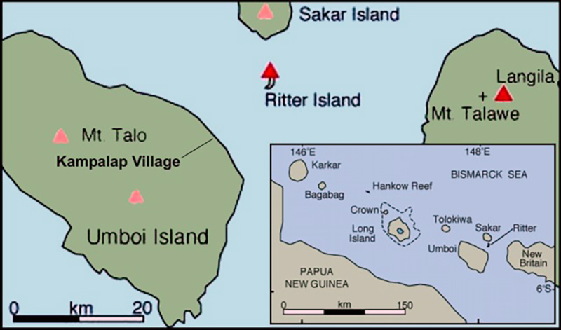 |
Figure 1. Location sketch maps showing the context of Ritter Island, which sits just E of New Britain Island and N of the main island. Many of the islands shown contain Holocene volcanoes along the same arc as New Britain Island. Courtesy of VolcanoWorld. |
On 2 August 2002, an advisory was issued by the Darwin VAAC based on a pilot observation indicating an ash cloud to ~ 3 km altitude, although satellite data was unable to confirm the presence of ash.
In what began as an ambiguous case, the Darwin VAAC issued an advisory for a 17 October 2006 eruption at Ritter Island. The initial report was confusing because a pilot had reported the eruption to the Rabaul Volcano Observatory (RVO) as being from Langila. The VAAC report noted that there was no plume at Langila in satellite imagery, but instead could see one farther W at Ritter Island. The plume was low and seen on MTSAT imagery (at 0133 UTC on 17 October); the presence of ash was not mentioned.
A report to RVO from Kampalap village, passed through the Langila observer, confirmed unusual activity on 17 October. RVO reported occasional small earthquakes followed by white vapor and diffuse ash clouds. The Kampalap observer saw occasional rock slides from the inner crater wall. Fine ash fell at Kampalap that the reporter indicated was not from Langila. No similar eruptive episodes were recorded through 1 November. Throughout this interval the RVO relied on seismic instrumentation in West New Britain, but an instrument was being prepared for possible deployment at Ritter Island.
Information Contacts: Herman Patia, Rabaul Volcanological Observatory (RVO), Department of Mining, Private Mail Bag, Port Moresby Post Office, National Capitol District, Papua New Guinea; VolcanoWorld (URL: http://volcano.oregonstate.edu/).
Eruption on 19 May causes landslides and sea surges
On 17 October 2006 occasional small earthquakes on Ritter Island were followed by emissions of white vapor and diffuse ash clouds, occasional rock slides from the inner crater wall, and ashfall on nearby Umboi (Siassi) Island (BGVN 32:03). No further activity was reported until 19 May 2007, when sea surges destroyed a boat and four houses on Umboi following an eruption, according to media quotes from Morobe Province disaster and emergency director Roy Kamen. Kamen also noted that 1,500-2,000 people from two villages had moved to higher ground for fear of tsunamis. As of 21 May residents could still hear rumbling noises, see "smoke" rising from Ritter Island, and feel tremors. The Rabaul Volcanological Observatory (RVO) and the Geophysical Observatory in Port Moresby did not record seismic activity from the eruption on their equipment.
Reports received by RVO from Jonathan Kuduon at Kilenge (western New Britain) on 30 May indicated evidence of high waves (4-10 m high) around Ritter Island, with a maximum of 10 m on the S part of the island. Scorched vegetation was seen in the same area, and dead marine animals, mainly reef fish, were seen around the coastline. There was no evidence of fresh volcanic material, but a new landslide scar was visible on the S tip of island, an area that extended from the uppermost part of the island (~100 m elevation) down to sea level. Several other small landslide scars were seen on the W wall. Rockfalls continued to produce clouds that could be seen from a distance. Seismic activity was low during one day of recording on 27-28 May; only four high-frequency earthquakes were recorded.
RVO noted that the event on 19 May was similar to the 1972 and 1974 events, in that they lasted only a few hours and were preceded by explosion noises followed by disturbance of the sea. Both the 1972 and 1974 activities occurred offshore, and landslides were triggered during the 1974 activity. The 19 May event may have been due submarine explosions or earthquakes associated with volcanic activity that triggered the landslide(s).
Information Contacts: Herman Patia, Rabaul Volcanological Observatory (RVO), Department of Mining, Private Mail Bag, Port Moresby Post Office, National Capitol District, Papua New Guinea; Australian Associated Press, AAP News Centre, 3 Rider Boulevard, Rhodes Waterside, Rhodes, NSW 2138, Australia (URL: http://aap.com.au/).
Report includes past geothermal activity observations
According to the Rabaul Volcanological Observatory, a "small (probably submarine) eruption was reported to have taken place at Ritter Island on 18 April 2014 (figures 2 and 3). At about 1700 hours, an earthquake was felt at Kampalap village on Umboi Island. At the same time the level of sea rose a little over normal but was confined to the beach at Kampalap. At around 0000 hours on 19 April, another felt earthquake occurred. The earthquakes were estimated to have an intensity at Kampalap of between II to III. No floating debris where seen, and no ash or damage was reported."
|
Figure 2. Location maps for Ritter Island. The upper map shows the region of Papua New Guinea containing Ritter Island and other volcanoes, and the lower map is enlargement of the center of the upper map focused on Ritter Island. From Saunders and Kuduon (2009). |
|
Figure 3. Oblique aerial view of Ritter Island photographed in 2006 by John Holder (the originator of Oceanic Expeditions) from SW looking NE, with some of the location names. From Saunders and Kuduon (2009). |
A Rabaul Volcanological Observatory (RVO) report by Saunder and Kuduon (2009) noted past possible geothermal activity on Ritter Island that had not been previously reported. According to their report, "In 1997 a patrol officer (Hita Mesere) in a media release relayed reports from Councilor Nalong (Kampalap Village?) of an explosive eruption and large waves reaching nearby villages. In the preparation of this report Mr. Mesere was contacted and he confirmed that he and officers from the Morobe PDO flew over Ritter after this event and saw white smoke coming from 'boiling' in the sea, close to land in the South Bay (Mesere, 2009 Pers. Comm.)."
The report concluded that "Ritter is active, both volcanically and geomorphologically. More volcanic activity can be expected. Seismically this will probably not be as intense as in the early 1970's, as the conduit seems now to be open. Volcanic phenomena may however increase in importance if the cone continues to grow towards the surface and magma is erupted into an environment of lower hydrostatic pressures. There seems to be two causes of eruptive activity, one is the rise of fresh magma at the site of the submarine cone and the other is slope instability causing water to come into contact with residual hot rocks leading to small hydrovolcanian events close inshore of Ritter."
The RVO report also included the following table (table 1) showing past observations of possible geothermal activity on Ritter Island.
Table 1. Dates and details of reported post-collapse activity at Ritter. From of Saunders and Kuduon (2009).
| Date | Seismic Intensity | Explosions reported | White steam reported | Dust/Dark material reported | Sound reported | Location of emission |
| 9 Oct. 1972 | Felt 35 km away; regionally recorded | Multiple | Y | Y | Strong rumbling | Inshore W (S Cove) & off terminal cusps |
| 17 Oct. 1974 | Felt 30 km away: recorded in PNG | Multiple | Y | Y | N | Offshore ~1 km W |
| 19 Oct. 1996? (Pilot report only) | None reported | N | Y | N | N | ? |
| 1997 | None reported | Single or few | Y | N | N | Inshore W (S Cove) |
| 17 Oct. 2006 | Few small, locally felt | N | Y | Y | N | Offshore ~1 km W |
| 19 May 2007 | None reported | Several | Y | Y (and flames) | Rumbling & 3 explosions | Offshore ~1 km W |
Tsunami of 1888. Several recent papers have revisited the 13 March 1888 collapse of Ritter Island volcano that generated a catastrophic tsunami. According to Ward and Day (2003), "In the early morning of 1888 March 13, roughly 5 km3 of Ritter Island Volcano fell violently into the sea northeast of New Guinea. This event, the largest lateral collapse of an island volcano to be recorded in historical time, flung devastating tsunami tens of meters high on to adjacent shores. Several hundred kilometers away, observers on New Guinea chronicled 3 min period waves up to 8 m high, that lasted for as long as 3 h. These accounts represent the best available first-hand information on tsunami generated by a major volcano lateral collapse." Eyewitness accounts noted the lack of explosive activity accompanying the collapse. In this paper, the authors simulated the Ritter Island landslide as constrained by a 1985 sonar survey of its debris field and compare predicted tsunami with historical observations.
Ray and others (2014) reported that, based on primary and secondary eyewitness accounts on the morning of 13 March 1888 "there is no clear evidence for a coincident [to the collapse] or causal magmatic explosive eruption. One report suggests that there was activity (perhaps phreatic or phreatomagmatic explosions?) prior to the collapse that lead some of the resident local communities to seek higher ground, but evidence for precursory flank movements or changes in eruptive style have not been found in the historical accounts."
References. Ray, M.J., Day, S., and Downes, H., 2014, The growth of Ritter Island volcano, Papua New Guinea, and the lateral collapse landslide and tsunami of 1888: new insights from eyewitness accounts, EGU General Assembly 2014, Geophysical Research Abstracts, v. 16, EGU2014-1305.
Saunders, S., and Kuduon, J., 2009, The June 2009 Investigation Of Ritter Volcano, With A Brief Discussion On Its Current Nature, Rabaul Volcanological Observatory Open File Report OFP 003/2009, 25 pp.
Ward, S.N., and Day, S. 2003. Ritter Island—lateral collapse and the tsunami of 1888. Geophysics Journal International, v. 154, pp. 891-902.
Information Contacts: Rabaul Volcanological Observatory, P.O. Box 386, Rabaul, Papua New Guinea.
|
|
||||||||||||||||||||||||||
There is data available for 8 confirmed eruptive periods.
2007 May 19 - 2007 May 21 (?) Confirmed Eruption (Explosive / Effusive) VEI: 1 (?)
| Episode 1 | Eruption (Explosive / Effusive) | ||||||||||||||||||||||||||||||||||||||||||||
|---|---|---|---|---|---|---|---|---|---|---|---|---|---|---|---|---|---|---|---|---|---|---|---|---|---|---|---|---|---|---|---|---|---|---|---|---|---|---|---|---|---|---|---|---|
| 2007 May 19 - 2007 May 21 (?) | Evidence from Observations: Reported | |||||||||||||||||||||||||||||||||||||||||||
|
List of 7 Events for Episode 1
|
||||||||||||||||||||||||||||||||||||||||||||
2006 Oct 17 - 2006 Oct 17 (?) Confirmed Eruption (Explosive / Effusive) VEI: 1 (?)
| Episode 1 | Eruption (Explosive / Effusive) | |||||||||||||||||||||||||||||
|---|---|---|---|---|---|---|---|---|---|---|---|---|---|---|---|---|---|---|---|---|---|---|---|---|---|---|---|---|---|
| 2006 Oct 17 - 2006 Oct 17 (?) | Evidence from Observations: Reported | ||||||||||||||||||||||||||||
|
List of 4 Events for Episode 1
|
|||||||||||||||||||||||||||||
[ 2002 Aug 2 - 2002 Aug 2 ] Uncertain Eruption
| Episode 1 | Eruption (Explosive / Effusive) | ||||||||||||||||||||||||
|---|---|---|---|---|---|---|---|---|---|---|---|---|---|---|---|---|---|---|---|---|---|---|---|---|
| 2002 Aug 2 - 2002 Aug 2 | Evidence from Unknown | |||||||||||||||||||||||
|
List of 3 Events for Episode 1
|
||||||||||||||||||||||||
1974 Oct 17 - 1974 Oct 17 Confirmed Eruption (Explosive / Effusive) VEI: 1
| Episode 1 | Eruption (Explosive / Effusive) | 600-900 m W of Ritter Island | ||||||||||||||||||||||||||||||||||||||
|---|---|---|---|---|---|---|---|---|---|---|---|---|---|---|---|---|---|---|---|---|---|---|---|---|---|---|---|---|---|---|---|---|---|---|---|---|---|---|---|
| 1974 Oct 17 - 1974 Oct 17 | Evidence from Observations: Reported | ||||||||||||||||||||||||||||||||||||||
|
List of 6 Events for Episode 1 at 600-900 m W of Ritter Island
|
|||||||||||||||||||||||||||||||||||||||
1972 Oct 9 - 1972 Oct 9 Confirmed Eruption (Explosive / Effusive) VEI: 1
| Episode 1 | Eruption (Explosive / Effusive) | West of Ritter Island | |||||||||||||||||||||||||||||||||||||||||||
|---|---|---|---|---|---|---|---|---|---|---|---|---|---|---|---|---|---|---|---|---|---|---|---|---|---|---|---|---|---|---|---|---|---|---|---|---|---|---|---|---|---|---|---|---|
| 1972 Oct 9 - 1972 Oct 9 | Evidence from Observations: Reported | |||||||||||||||||||||||||||||||||||||||||||
|
List of 7 Events for Episode 1 at West of Ritter Island
|
||||||||||||||||||||||||||||||||||||||||||||
1888 Mar 13 - 1888 Mar 13 Confirmed Eruption (Explosive / Effusive) VEI: 2 (?)
| Episode 1 | Eruption (Explosive / Effusive) | ||||||||||||||||||||||||||||||||||||||||||||||||||||||
|---|---|---|---|---|---|---|---|---|---|---|---|---|---|---|---|---|---|---|---|---|---|---|---|---|---|---|---|---|---|---|---|---|---|---|---|---|---|---|---|---|---|---|---|---|---|---|---|---|---|---|---|---|---|---|
| 1888 Mar 13 - 1888 Mar 13 | Evidence from Observations: Reported | |||||||||||||||||||||||||||||||||||||||||||||||||||||
|
List of 9 Events for Episode 1
|
||||||||||||||||||||||||||||||||||||||||||||||||||||||
1887 Feb 2 - 1887 Feb 5 Confirmed Eruption (Explosive / Effusive) VEI: 2
| Episode 1 | Eruption (Explosive / Effusive) | Volcano Uncertain: Probably Ritter or Langila | ||||||||||||||||||||||||||||
|---|---|---|---|---|---|---|---|---|---|---|---|---|---|---|---|---|---|---|---|---|---|---|---|---|---|---|---|---|---|
| 1887 Feb 2 - 1887 Feb 5 | Evidence from Unknown | ||||||||||||||||||||||||||||
|
List of 4 Events for Episode 1 at Volcano Uncertain: Probably Ritter or Langila
|
|||||||||||||||||||||||||||||
[ 1885 Jan 13 (?) ] Uncertain Eruption
| Episode 1 | Eruption (Explosive / Effusive) | ||||||||||||||
|---|---|---|---|---|---|---|---|---|---|---|---|---|---|---|
| 1885 Jan 13 (?) - Unknown | Evidence from Unknown | |||||||||||||
|
List of 1 Events for Episode 1
|
||||||||||||||
[ 1878 Dec 31 ± 30 days ] Uncertain Eruption
| Episode 1 | Eruption (Explosive / Effusive) | ||||||||||||||
|---|---|---|---|---|---|---|---|---|---|---|---|---|---|---|
| 1878 Dec 31 ± 30 days - Unknown | Evidence from Unknown | |||||||||||||
|
List of 1 Events for Episode 1
|
||||||||||||||
[ 1848 Apr 13 - 1848 Jul 10 (?) ] Uncertain Eruption
| Episode 1 | Eruption (Explosive / Effusive) | ||||||||||||||
|---|---|---|---|---|---|---|---|---|---|---|---|---|---|---|
| 1848 Apr 13 - 1848 Jul 10 (?) | Evidence from Unknown | |||||||||||||
|
List of 1 Events for Episode 1
|
||||||||||||||
1793 Jun 29 Confirmed Eruption (Explosive / Effusive) VEI: 2
| Episode 1 | Eruption (Explosive / Effusive) | ||||||||||||||||||||||||
|---|---|---|---|---|---|---|---|---|---|---|---|---|---|---|---|---|---|---|---|---|---|---|---|---|
| 1793 Jun 29 - Unknown | Evidence from Observations: Reported | |||||||||||||||||||||||
|
List of 3 Events for Episode 1
|
||||||||||||||||||||||||
1700 Apr 3 (on or before) - 1700 Apr 6 (on or after) Confirmed Eruption (Explosive / Effusive) VEI: 3
| Episode 1 | Eruption (Explosive / Effusive) | ||||||||||||||||||||||||||||||||||
|---|---|---|---|---|---|---|---|---|---|---|---|---|---|---|---|---|---|---|---|---|---|---|---|---|---|---|---|---|---|---|---|---|---|---|
| 1700 Apr 3 (on or before) - 1700 Apr 6 (on or after) | Evidence from Observations: Reported | |||||||||||||||||||||||||||||||||
|
List of 5 Events for Episode 1
|
||||||||||||||||||||||||||||||||||
This compilation of synonyms and subsidiary features may not be comprehensive. Features are organized into four major categories: Cones, Craters, Domes, and Thermal Features. Synonyms of features appear indented below the primary name. In some cases additional feature type, elevation, or location details are provided.
Synonyms |
| Kulkul | Vulcano Island |
There are no samples for Ritter Island in the Smithsonian's NMNH Department of Mineral Sciences Rock and Ore collection.
| Copernicus Browser | The Copernicus Browser replaced the Sentinel Hub Playground browser in 2023, to provide access to Earth observation archives from the Copernicus Data Space Ecosystem, the main distribution platform for data from the EU Copernicus missions. |
| MIROVA | Middle InfraRed Observation of Volcanic Activity (MIROVA) is a near real time volcanic hot-spot detection system based on the analysis of MODIS (Moderate Resolution Imaging Spectroradiometer) data. In particular, MIROVA uses the Middle InfraRed Radiation (MIR), measured over target volcanoes, in order to detect, locate and measure the heat radiation sourced from volcanic activity. |
| MODVOLC Thermal Alerts | Using infrared satellite Moderate Resolution Imaging Spectroradiometer (MODIS) data, scientists at the Hawai'i Institute of Geophysics and Planetology, University of Hawai'i, developed an automated system called MODVOLC to map thermal hot-spots in near real time. For each MODIS image, the algorithm automatically scans each 1 km pixel within it to check for high-temperature hot-spots. When one is found the date, time, location, and intensity are recorded. MODIS looks at every square km of the Earth every 48 hours, once during the day and once during the night, and the presence of two MODIS sensors in space allows at least four hot-spot observations every two days. Each day updated global maps are compiled to display the locations of all hot spots detected in the previous 24 hours. There is a drop-down list with volcano names which allow users to 'zoom-in' and examine the distribution of hot-spots at a variety of spatial scales. |
|
WOVOdat
Single Volcano View Temporal Evolution of Unrest Side by Side Volcanoes |
WOVOdat is a database of volcanic unrest; instrumentally and visually recorded changes in seismicity, ground deformation, gas emission, and other parameters from their normal baselines. It is sponsored by the World Organization of Volcano Observatories (WOVO) and presently hosted at the Earth Observatory of Singapore.
GVMID Data on Volcano Monitoring Infrastructure The Global Volcano Monitoring Infrastructure Database GVMID, is aimed at documenting and improving capabilities of volcano monitoring from the ground and space. GVMID should provide a snapshot and baseline view of the techniques and instrumentation that are in place at various volcanoes, which can be use by volcano observatories as reference to setup new monitoring system or improving networks at a specific volcano. These data will allow identification of what monitoring gaps exist, which can be then targeted by remote sensing infrastructure and future instrument deployments. |
| Volcanic Hazard Maps | The IAVCEI Commission on Volcanic Hazards and Risk has a Volcanic Hazard Maps database designed to serve as a resource for hazard mappers (or other interested parties) to explore how common issues in hazard map development have been addressed at different volcanoes, in different countries, for different hazards, and for different intended audiences. In addition to the comprehensive, searchable Volcanic Hazard Maps Database, this website contains information about diversity of volcanic hazard maps, illustrated using examples from the database. This site is for educational purposes related to volcanic hazard maps. Hazard maps found on this website should not be used for emergency purposes. For the most recent, official hazard map for a particular volcano, please seek out the proper institutional authorities on the matter. |
| IRIS seismic stations/networks | Incorporated Research Institutions for Seismology (IRIS) Data Services map showing the location of seismic stations from all available networks (permanent or temporary) within a radius of 0.18° (about 20 km at mid-latitudes) from the given location of Ritter Island. Users can customize a variety of filters and options in the left panel. Note that if there are no stations are known the map will default to show the entire world with a "No data matched request" error notice. |
| UNAVCO GPS/GNSS stations | Geodetic Data Services map from UNAVCO showing the location of GPS/GNSS stations from all available networks (permanent or temporary) within a radius of 20 km from the given location of Ritter Island. Users can customize the data search based on station or network names, location, and time window. Requires Adobe Flash Player. |
| DECADE Data | The DECADE portal, still in the developmental stage, serves as an example of the proposed interoperability between The Smithsonian Institution's Global Volcanism Program, the Mapping Gas Emissions (MaGa) Database, and the EarthChem Geochemical Portal. The Deep Earth Carbon Degassing (DECADE) initiative seeks to use new and established technologies to determine accurate global fluxes of volcanic CO2 to the atmosphere, but installing CO2 monitoring networks on 20 of the world's 150 most actively degassing volcanoes. The group uses related laboratory-based studies (direct gas sampling and analysis, melt inclusions) to provide new data for direct degassing of deep earth carbon to the atmosphere. |
| Large Eruptions of Ritter Island | Information about large Quaternary eruptions (VEI >= 4) is cataloged in the Large Magnitude Explosive Volcanic Eruptions (LaMEVE) database of the Volcano Global Risk Identification and Analysis Project (VOGRIPA). |
| EarthChem | EarthChem develops and maintains databases, software, and services that support the preservation, discovery, access and analysis of geochemical data, and facilitate their integration with the broad array of other available earth science parameters. EarthChem is operated by a joint team of disciplinary scientists, data scientists, data managers and information technology developers who are part of the NSF-funded data facility Integrated Earth Data Applications (IEDA). IEDA is a collaborative effort of EarthChem and the Marine Geoscience Data System (MGDS). |


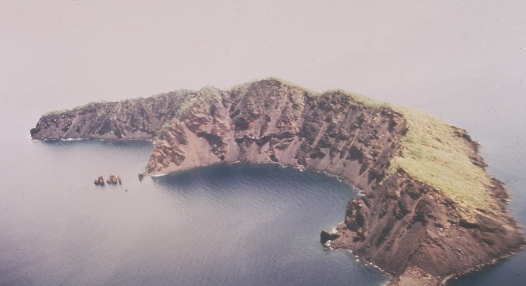
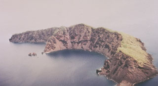 This arcuate, 1.9-km-long, 200-m-wide island is what remains of Ritter Island after its collapse in 1888. Prior to 1888 this was a steep-sided nearly circular island about 780 m high. Large-scale slope failure removed the summit of the conical volcano, leaving an arcuate 140-m-high west-facing scarp, seen here from the SW. Two minor post-collapse explosive eruptions occurred offshore during 1972 and 1974.