Report on Krakatau (Indonesia) — November 2009
Bulletin of the Global Volcanism Network, vol. 34, no. 11 (November 2009)
Managing Editor: Richard Wunderman.
Krakatau (Indonesia) Ongoing eruptive signals and earthquakes through 29 October 2009
Please cite this report as:
Global Volcanism Program, 2009. Report on Krakatau (Indonesia) (Wunderman, R., ed.). Bulletin of the Global Volcanism Network, 34:11. Smithsonian Institution. https://doi.org/10.5479/si.GVP.BGVN200911-262000
Krakatau
Indonesia
6.1009°S, 105.4233°E; summit elev. 285 m
All times are local (unless otherwise noted)
Our previous report on Krakatau (BGVN 35:05) covered activity from October 2007 to 18 June 2009, discussing an increase in seismicity and eruptions that began in late March 2009 after a 7-month gap in MODVOLC thermal alerts. This report chiefly focuses on activity during 3 July 2009 through 29 October 2009 based on Volcanic Ash Advisory Centre (VAAC) reports and monitoring from coastal Java at the Pasauran observation post in Banten province.
As an overview of hazard status during the past few years, the Center of Volcanology and Geological Hazard Mitigation (CVGHM) noted that starting 3 July 2008, Anak Krakatau had been at Alert Level 2 (Waspada). On 25 March 2009 activity increased significantly, with the recording of 19 eruptions. Eruptive activity then continued without pause until 6 May 2009 when the hazard status was elevated to Alert Level 3 (Siaga). Based on a decline in seismic and eruptive activity, on 31 October CVGHM decreased the status to Level 2.
The Darwin Volcanic Ash Advisory Center (VAAC) reported that a pilot observed an ash plume at 1948 (local time) on 3 July 2009 that rose to altitude below 3 km. The VAAC did not detected the plume on satellite imagery.
According to CVGHM, activity steadily declined during August and to at least as late as 29 October 2009 (table 7). Visual observations of the summit were often obstructed by fog, although a gray cloud rising as high as 1,300 m above the summit was observed at a clear moment on one undisclosed day in August. Booming eruptive sounds were recorded 49 times in August and once in September.
Table 7. Seismically detected signals at Krakatau, including tremor and earthquake, registered by the Pasauran observation post during August 2009 through 29 October 2009. Instrument locations were discussed in BGVN 32:09 (although the status of these stations was not discussed). Where reported the table also presents ranges of amplitudes (in millimeters, mm), duration (in seconds, s), and S-wave minus P-wave arrival times (S-P). Courtesy of CVGHM.
| Month | Eruptive signals | Air signals | Tremor events | Shallow volcanic earthquakes | Deep volcanic earthquakes |
| Aug 2009 | 4,311 (amplitude 3-46 mm, duration 7-114 s) | 2,394 (2-22 mm, 10-140 s) | 886 (2-46 mm, 5-547 s) | 2,649 (2-20 mm, 2-18.5 s) | 9 (18-37 mm, 6-25 s, S-P 0.5-2 s) |
| Sep 2009 | 541 (amplitude 7-45 mm, duration 8-226 s) Latest 18 Sep. | 356 (2-20 mm, 11-161 s) | 278 (6-46 mm, 35-635 s) | 721 (2-20 mm, 2-17 s) | 17 (15-45 mm, S-P 0.5-2.5 s) |
| Oct 2009 | 34 (amplitude 6-63 mm, duration 15-195 s) Only 26 Oct. | 16 (4-23 mm, 13-81 s) | -- | 159 (2.5-26 mm, 2.5-14 s) | 20 (12-65 mm, 6-27 s, S-P 0.5-2.5 s) |
CVGHM also reported two major seismic events over the reporting period at distance from Krakatau with little discernable impact there. On 16 August 2009 at 1438, a tectonic earthquake originating on the southern side of Pulau Siberut island, located ~ 900 km to the NW of Krakatau, was recorded with a magnitude of 6.9. On 16 October 2009, a tectonic earthquake originating from Ujung Kulon-Jawa Barat, located at the W tip of Java, occurred with a magnitude of 6.4. CVGHM stated that the volcanic seismic signals at Krakatau following the earthquakes on 16 August and 16 October do not indicate an increase in volcanism.
Frequent MODVOLC thermal alerts were recorded during 1 April to 31 August 2009.
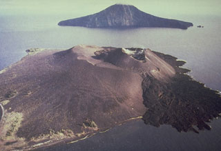
Geological Summary. The renowned Krakatau (frequently mis-named as Krakatoa) volcano lies in the Sunda Strait between Java and Sumatra. Collapse of an older edifice, perhaps in 416 or 535 CE, formed a 7-km-wide caldera. Remnants of that volcano are preserved in Verlaten and Lang Islands; subsequently the Rakata, Danan, and Perbuwatan cones were formed, coalescing to create the pre-1883 Krakatau Island. Caldera collapse during the catastrophic 1883 eruption destroyed Danan and Perbuwatan, and left only a remnant of Rakata. This eruption caused more than 36,000 fatalities, most as a result of tsunamis that swept the adjacent coastlines of Sumatra and Java. Pyroclastic surges traveled 40 km across the Sunda Strait and reached the Sumatra coast. After a quiescence of less than a half century, the post-collapse cone of Anak Krakatau (Child of Krakatau) was constructed within the 1883 caldera at a point between the former Danan and Perbuwatan cones. Anak Krakatau has been the site of frequent eruptions since 1927.
Information Contacts: Center of Volcanology and Geological Hazard Mitigation (CVGHM), Jalan Diponegoro 57, Bandung 40122, Indonesia (URL: http://vsi.esdm.go.id/); Darwin Volcanic Ash Advisory Centre (VAAC), Bureau of Meteorology, Northern Territory Regional Office, PO Box 40050, Casuarina, NT 0811, Australia (URL: http://www.bom.gov.au/info/vaac/); Hawai'i Institute of Geophysics and Planetology (HIGP) Thermal Alerts System, School of Ocean and Earth Science and Technology (SOEST), Univ. of Hawai'i, 2525 Correa Road, Honolulu, HI 96822, USA (URL: http://modis.higp.hawaii.edu/).

