Report on Kikai (Japan) — January 2013
Bulletin of the Global Volcanism Network, vol. 38, no. 1 (January 2013)
Managing Editor: Richard Wunderman.
Kikai (Japan) Steam plumes rose to 800 m duing latter half of 2012
Please cite this report as:
Global Volcanism Program, 2013. Report on Kikai (Japan) (Wunderman, R., ed.). Bulletin of the Global Volcanism Network, 38:1. Smithsonian Institution. https://doi.org/10.5479/si.GVP.BGVN201301-282060
Kikai
Japan
30.793°N, 130.305°E; summit elev. 704 m
All times are local (unless otherwise noted)
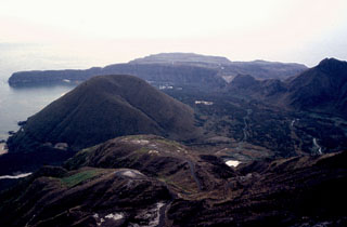
Kikai is a 17 x 20 km mostly submarine caldera as close as ~40 km from the S margin of the island of Kyushu (see figure 1 in BGVN 37:07; also see Shinohara and others, 2002, for 16 journal articles devoted to this volcano. Maeno, 2008, offers an online overview). A few areas on the caldera rim lie above water (figure 2). Mild-to-moderate emissions have often occurred at the dome called Iwo-dake (alternately spelled Iodake, figure 2). Table 4 summarizes the seismicity and steam plume observations for July-December 2012, an interval of calm, absence of tremor, and low hazard status.
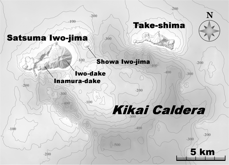 |
Figure 2. A shaded-relief, contour map of Kikai caldera that labels three islands on the N caldera rim, Satsuma Iwo-jima, Showa Iwo-jima, and Take-shima. Satsuma Iwo-jima contains the highest point of the complex (704 m elevation). On that island, the cones Iwo-dake (a rhyolitic volcano) and Inamura-dake (a basaltic volcano) both reflect post-caldera volcanism focused along or just inside the caldera's wall (the shaded, scalloped line trending NE across the island). The island Showa Iwo-jima emerged during the caldera's last major eruptions, during 1934-1935, starting with floating pumices and including late-stage lava emissions that helped armor the island and allowed it to erode only modestly during the subsequent decades of breaking waves. The caldera floor chiefly resides 300-500 m below sea level but it also contains some post-eruptive cones. From Fukashi Maeno (2008). |
Table 4. Monthly summary of seismicity and plume observations at Kikai during July-December 2012. All reported plumes were described as white. Data courtesy of JMA.
| Month | Earthquakes per month | Maximum steam plume height (m above Iwo-dake crater rim) |
| Jul 2012 | 238 | 800 |
| Aug 2012 | 187 | 300 |
| Sep 2012 | 193 | 500 |
| Oct 2012 | 219 | 700 |
| Nov 2012 | 168 | 400 |
| Dec 2012 | -- | -- |
We last reported on Kikai activity through mid-2012 (BGVN 37:07) covering generally small steam plumes and monthly seismicity of up to ~200 earthquakes per month through June 2012. This report is a compilation of subsequent monthly reports of volcanic activity through December 2012 from Japan Meteorological Agency (JMA) monthly reports. The Alert Level remained constant at Level 2 (on a scale of 1-5: 2 = "Do not approach the crater"), before being downgraded to Level 1 in December 2012.
Between July and September 2012, plume emissions at the Iwo-dake summit crater continued (table 4). Weak incandescence was recorded at night with a high-sensitivity camera on 22 July, 28 August, 6 November and 22-24 November. Seismic activity remained at low levels. No unusual ground deformation was observed in GPS data through December 2012.
An aerial observation conducted by the Japan Maritime Self-Defense Force (JMSDF) on 11 September 2012 revealed white plumes rising from Iwo-dake's summit crater and flanks.
The results of a field survey conducted from 17-20 November 2012 showed no remarkable change in white fumes from Iwo-dake. Infrared images also found that the temperature distribution had remained essentially unchanged. Aerial monitoring conducted by the Japan Coast Guard (JCG) on 25 November 2012 revealed the presence of brown and green discolored water around the eastern coast (similar findings as a previous survey) as well as patterns of steaming similar to those observed during the field survey. SO2 emissions during 17-20 November 2012 were measured to be ~400 tons/day; a previous survey conducted in July 2012 yielded an estimated flux of ~500 tons/day.
References. Shinohara, H., Iguchi, M., Hedenquist, J.W., and Koyaguchi, T., 2002, Preface to special volume, Earth, Planets and Space 54 (3), pp. 173-174.
Maeno, F, 2008, Geology and eruptive history of Kikai Caldera, Earthquake Research Institute, University of Tokyo (URL: http://www.eri.u-tokyo.ac.jp/fmaeno/kikai/kikaicaldera.html); accessed 23 February 2013.
Geological Summary. Multiple eruption centers have exhibited recent activity at Kikai, a mostly submerged, 19-km-wide caldera near the northern end of the Ryukyu Islands south of Kyushu. It was the source of one of the world's largest Holocene eruptions about 6,300 years ago when rhyolitic pyroclastic flows traveled across the sea for a total distance of 100 km to southern Kyushu, and ashfall reached the northern Japanese island of Hokkaido. The eruption devastated southern and central Kyushu, which remained uninhabited for several centuries. Post-caldera eruptions formed Iodake (or Iwo-dake) lava dome and Inamuradake scoria cone, as well as submarine lava domes. Recorded eruptions have occurred at or near Satsuma-Iojima (also known as Tokara-Iojima), a small 3 x 6 km island forming part of the NW caldera rim. Showa-Iojima lava dome (also known as Iojima-Shinto), a small island 2 km E of Satsuma-Iojima, was formed during submarine eruptions in 1934 and 1935. Mild-to-moderate explosive eruptions have occurred during the past few decades from Iodake, a rhyolitic lava dome at the eastern end of Satsuma-Iojima.
Information Contacts: Japan Meteorological Agency (JMA), Otemachi, 1-3-4, Chiyoda-ku Tokyo 100-8122, Japan (URL: http://www.jma.go.jp/); MODVOLC, Hawai'i Institute of Geophysics and Planetology (HIGP), MODVOLC Thermal Alerts System, School of Ocean and Earth Science and Technology (SOEST), Univ. of Hawai'i, 2525 Correa Road, Honolulu, HI 96822, USA (URL: http://modis.higp.hawaii.edu/).