Report on Kikai (Japan) — February 2020
Bulletin of the Global Volcanism Network, vol. 45, no. 2 (February 2020)
Managing Editor: Edward Venzke.
Edited by A. Elizabeth Crafford.
Kikai (Japan) Single explosion with steam and minor ash, 2 November 2019
Please cite this report as:
Global Volcanism Program, 2020. Report on Kikai (Japan) (Crafford, A.E., and Venzke, E., eds.). Bulletin of the Global Volcanism Network, 45:2. Smithsonian Institution. https://doi.org/10.5479/si.GVP.BGVN202002-282060
Kikai
Japan
30.793°N, 130.305°E; summit elev. 704 m
All times are local (unless otherwise noted)
The 19-km-wide submerged Kikai caldera at the N end of Japan’s Ryukyu Islands was the source of one of the world's largest Holocene eruptions about 6,300 years ago, producing large pyroclastic flows and abundant ashfall. During the last century, however, only intermittent minor ash emissions have characterized activity at Satsuma Iwo Jima island, the larger subaerial fragment of the Kikai caldera; several events have included limited ashfall in communities on nearby islands. The most recent event was a single day of explosions on 4 June 2013 that produced ash plumes and minor ashfall on the flank. A minor episode of increased seismicity and fumarolic activity was reported in late March 2018, but no ash emissions were reported. A new single-day event on 2 November 2019 is described here with information provided by the Japan Meteorological Agency (JMA).
JMA reduced the Alert Level to 1 on 27 April 2018 after a brief increase in seismicity during March 2018 (BGVN 45:05); no significant changes in volcanic activity were observed for the rest of the year. Steam plumes rose from the summit crater to heights around 1,000 m; the highest plume rose 1,800 m. Occasional nighttime incandescence was recorded by high-sensitivity surveillance cameras. SO2 measurements made during site visits in March, April, and May indicated amounts ranging from 300-1,500 tons per day, similar to values from 2017 (400-1,000 tons per day). Infrared imaging devices indicated thermal anomalies from fumarolic activity persisted on the N and W flanks during the three site visits. A field survey of the SW flank on 25 May 2018 confirmed that the crater edge had dropped several meters into the crater since a similar survey in April 2007. Scientists on a 19 December 2018 overflight had observed fumarolic activity.
There were no changes in activity through October 2019. Weak incandescence at night continued to be periodically recorded with the surveillance cameras (figure 11). A brief eruption on 2 November 2019 at 1735 local time produced a gray-white plume that rose slightly over 1,000 m above the Iodake crater rim (figure 12). As a result, JMA raised the Alert Level from 1 to 2. During an overflight the following day, a steam plume rose a few hundred meters above the summit, but no further activity was observed. No clear traces of volcanic ash or other ejecta were found around the summit (figure 13). Infrared imaging also showed no particular changes from previous measurements. Discolored seawater continued to be observed around the base of the island in several locations.
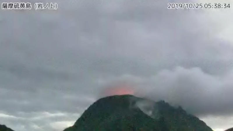 |
Figure 11. Incandescence at night on 25 October 2019 was observed at Satsuma Iwo Jima (Kikai) with the Iwanogami webcam. Courtesy of JMA (An explanation of volcanic activity at Satsuma Iwo Jima, October 1st year of Reiwa [2019]). |
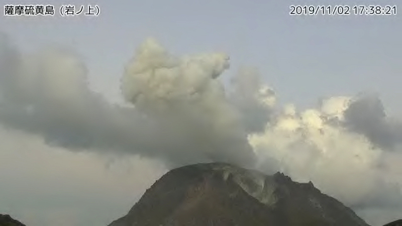 |
Figure 12. The Iwanogami webcam captured a brief gray-white ash and steam emission rising above the Iodake crater rim on Satsuma Iwo Jima (Kikai) on 2 November 2019 at 1738 local time. The plume rose slightly over 1,000 m before dissipating. Courtesy of JMA (An explanation of volcanic activity at Satsuma Iwo Jima, October 1st year of Reiwa [2019]). |
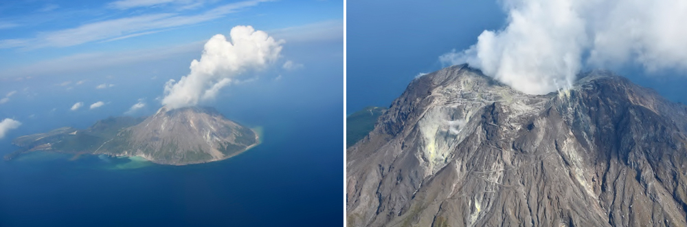 |
Figure 13. During an overflight of Satsuma Iwo Jima (Kikai) on 3 November 2019 no traces of ash were seen from the previous day’s explosion; only steam plumes rose a few hundred meters above the summit, and discolored water was present in a few places around the shoreline. Courtesy of JMA (An explanation of volcanic activity at Satsuma Iwo Jima, October 1st year of Reiwa [2019]). |
For the remainder of November 2019, steam plumes rose up to 1,300 m above the summit, and nighttime incandescence was occasionally observed in the webcam. Seismic activity remained low and there were no additional changes noted through January 2020.
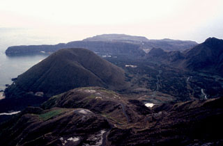
Geological Summary. Multiple eruption centers have exhibited recent activity at Kikai, a mostly submerged, 19-km-wide caldera near the northern end of the Ryukyu Islands south of Kyushu. It was the source of one of the world's largest Holocene eruptions about 6,300 years ago when rhyolitic pyroclastic flows traveled across the sea for a total distance of 100 km to southern Kyushu, and ashfall reached the northern Japanese island of Hokkaido. The eruption devastated southern and central Kyushu, which remained uninhabited for several centuries. Post-caldera eruptions formed Iodake (or Iwo-dake) lava dome and Inamuradake scoria cone, as well as submarine lava domes. Recorded eruptions have occurred at or near Satsuma-Iojima (also known as Tokara-Iojima), a small 3 x 6 km island forming part of the NW caldera rim. Showa-Iojima lava dome (also known as Iojima-Shinto), a small island 2 km E of Satsuma-Iojima, was formed during submarine eruptions in 1934 and 1935. Mild-to-moderate explosive eruptions have occurred during the past few decades from Iodake, a rhyolitic lava dome at the eastern end of Satsuma-Iojima.
Information Contacts: Japan Meteorological Agency (JMA), Otemachi, 1-3-4, Chiyoda-ku Tokyo 100-8122, Japan (URL: http://www.jma.go.jp/jma/indexe.html).