Report on Atka Volcanic Complex (United States) — March 1987
Scientific Event Alert Network Bulletin, vol. 12, no. 3 (March 1987)
Managing Editor: Lindsay McClelland.
Atka Volcanic Complex (United States) Ash eruption from Korovin summit and two nearby vents
Please cite this report as:
Global Volcanism Program, 1987. Report on Atka Volcanic Complex (United States) (McClelland, L., ed.). Scientific Event Alert Network Bulletin, 12:3. Smithsonian Institution. https://doi.org/10.5479/si.GVP.SEAN198703-311160
Atka Volcanic Complex
United States
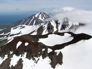
52.331°N, 174.139°W; summit elev. 1518 m
All times are local (unless otherwise noted)
On 18 March at 1954 a NOAA 10 satellite image showed three distinct plumes, each 95 km long, drifting ENE. The estimated vent locations were: 52.38°N, 174.15°W (Korovin's summit); 52.31°N, 174.24°W; and 52.29°N, 174.21°W (5.5 km WSW and 6.5 km SW of Mt. Kliuchef, a cone on Korovin's S flank). More accurate locations will be determined by USGS Anchorage. Just before midnight on the same day US Navy pilot Jeffrey Sullivan observed a southward-drifting ash plume rising to at least 3,000 m altitude, lit by an orange "flame" from Korovin. Smaller orange flickering "flames" from two other vents at lower elevation were visible. Two of the vents were ~2 km apart and the third vent was ~10 km NE of the other two vents.
Earlier in the day (at 1300) Julie Dirks and other Atka residents noticed sulfur smells (~18 km from the volcano). Although the weather was clear Dirks did not notice any "unusual" eruptive activity. On 19 March a SIGMET notice was issued to warn pilots of volcanic ash 185 km on either side of a line from 52°N, 175°W to 54°N, 172°W. The warning remained in effect until 0930. Pilots reported that the ash cloud reached 3,600 m.
Geological Summary. The Atka Volcanic Complex consists of a central shield and Pleistocene caldera and four notable volcanic cones. A major explosive dacitic eruption accompanied formation of the caldera about 500,000 to 300,000 years ago; approximately half of the caldera rime remains, open towards the NW. The Sarichef cone, ~5 km ESE of the caldera rim, retains a symmetrical profile, unlike most other heavily eroded features outside the caldera to the S and W. The Kliuchef stratovolcano grew within the caldera and exhibits five eruptive vents striking NE, including two at the summit, that have been active in the Holocene. A 700-m-diameter crater 1 km NE of the summit may have been the source vent for a large 1812 CE eruption. Hot springs and fumaroles are located on the flanks of Kliuchef and in a glacial valley to the SW. The most frequently active volcano of the complex is Korovin, at the NE tip of Atka Island about 5 km N of Kliuchef. An 800-m-diameter crater on the SE side of the summit contains a deep circular pit that sometimes contains a crater lake thought to be the source of phreatic ash explosions. The smaller Konia cone, slightly offset to the E, lies between Kliuchef and Korovin. Most of the lava flows in the complex are basaltic, though some dacitic flows are also present.
Information Contacts: J. Reeder, ADGGS; M. Matson, NOAA/NESDIS; T. Miller, USGS, Anchorage.