

At 1200 on 5 May the Alaska Volcano Observatory (AVO) lowered the Volcano Alert Level for the Atka volcanic complex to Normal (the lowest level on a four-level scale) and the Aviation Color Code to Green (the lowest color on a four-color scale). AVO noted that no additional explosive activity was recorded after the small explosive event at 1034 on 25 April.
Source: US Geological Survey Alaska Volcano Observatory (AVO)
Summary of activity during 1998-2007
Korovin is a stratovolcano located on Atka Island in the central Aleutian Islands; its most recent reported activity ended in 2007. This report summarizes and contains new information on activity from 1998 to 2007 by drawing on information primarily from the Alaska Volcano Observatory (AVO) and their cited publications. Much of the summary takes the form of a table at the end of the report.
Atka volcanic complex. According to Myers and others (2002) Korovin is a part of the 360 km2 Atka volcanic complex, found on the northern part of Atka Island. It is the largest modern complex within the central Aleutians (Myers and others, 2002). The ancestral Atka volcano, in the complex, was described as a large shield volcano consisting of basaltic and basaltic andesite flows, which was subsequently surrounded by a series of satellite vents (Myers and others, 2002).
A caldera forming eruption at the Atka shield volcano occurred ~300,000-500,000 years ago, creating a 5-km-diameter caldera. Associated with that event was the eruption of a large dacitic flow, called Big Pink. Regarding the composition of Big Pink, Myers and others (2002) said, "It consists of pumiceous and glassy units but is not associated with any ash flows." After the caldera formation, the volcanic centers of Korovin, Kliuchef, Konia and Sarichef formed. Figure 4 is a topographic map showing the location of these four volcanic centers and the location of the Atka caldera. These structures all comprise the Atka volcanic complex.
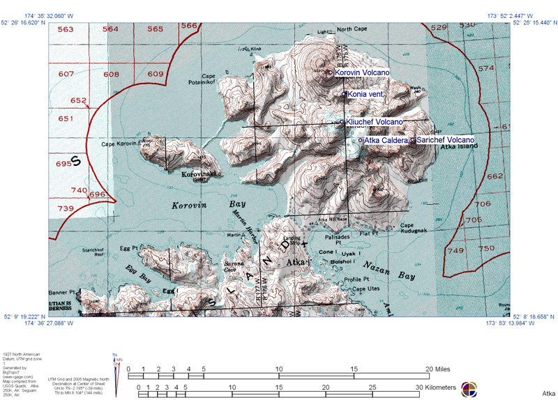 |
Figure 4. Topographical map of the northern part of Atka Island, located in the central Aleutian Islands. The map highlights the locations of the Atka caldera, the Korovin, Kliuchef and Sarichef volcanoes and the Konia vent, which all comprise the Atka volcanic complex. Image created by the Alaska Volcano Observatory (AVO) and U.S Geological Survey (USGS) using BigTopo 7 software and AllTopo 7. Image taken from the AVO website. |
Korovin volcano. Korovin is located 21 km NE from the town of Atka (figure 4). It is the largest and tallest volcano of the post-caldera volcanic centers within the Atka volcanic complex. According to Myers and others (2002), Korovin shows little evidence of glaciation, unlike Kliuchef, located ~5 km S of Korovin. Regarding Korovin' edifice and age, Myers and others (2002) say "Its uneroded form suggests the volcano is mostly Holocene in age."
Korovin has a basal diameter of ~7 km and two summit vents located 0.6 km apart (Myers and others, 2002). The NW summit vent has a small crater and is the lower of the two vents. The SE summit has a 1 km wide crater, with steep walls and a depth of several hundred meters (Myers and others, 2002). The SE summit crater sometimes contains a crater lake and is considered Korovin's active crater. Figure 5 is an aerial photo of Korovin, highlighting its two summit vents.
 |
Figure 5. Photograph of Korovin volcano taken from an aircraft flying at 9.1 km altitude on 5 August 2007. The view is oblique and from the N (i.e. looking S). Steam is rising from the active crater (SE crater). The summit of Kliuchef volcano is partially visible at the top of the image; it sits ~5 km S of Korovin. Photograph taken by Burke Mees, Alaska Airlines. Photograph from McGimsey and others (2011). |
During the summer of 2004, AVO installed a network of seismic stations throughout the northern part of Atka Island. Data from the network was accessible in March 2005; however, it wasn't until December 2005 that Korovin was considered seismically monitored. On 2 December 2005, Korovin was also officially assigned the Level of Concern Color Code Green after "a sufficient period of background seismicity had been recorded" (McGimsey and others, 2007). Before, AVO had listed Korovin as UA (unassigned) during periods when no significant activity was noted. AVO assigns volcanoes UA when there is no real-time seismic network in the area that can be used to define background levels of seismicity.
In addition to being seismically monitored, Korovin is also monitored through ground-based, aerial, and satellite imagery and photographs. Korovin and its plumes are often photographed by residents of Atka village (figures 6 and 7), which are then sent to the AVO. Figure 8 provides examples of photos of Korovin taken from satellites. Images from figures 6-8 furnish various kinds of evidence, from steaming (i.e. non-eruptive cases, figure 7), ash-bearing plumes (figure 6), and the result of ash-bearing eruptions (ash on the snow surface seen in satellite views, figure 8). Evidence of these kinds is summarized in next section.
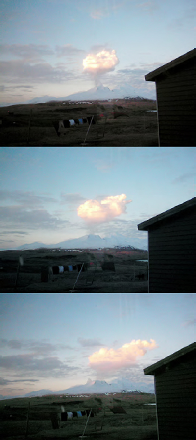 |
Figure 6. Photographs showing the progression of a steam plume that developed over Kovorin around 1900 on 23 February 2005. Plume was observed drifting to the E, and ash was seen falling out near the base of the plume. These photos were taken in Atka village and are courtesy of Louis and Kathleen Nevzoroff. Photos were taken from McGimsey and others (2008). |
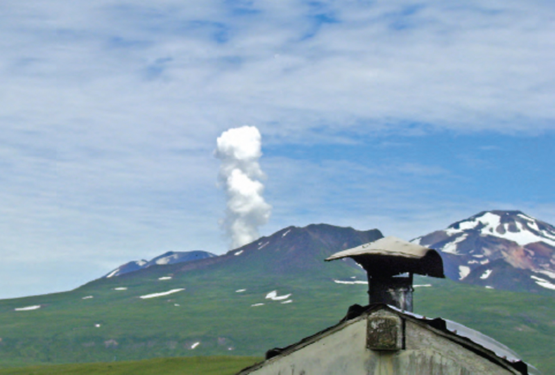 |
Figure 7. Photograph of a steam column rising from Korovin on 27 July 2007. Steam was estimated to reach ~215-245 m above the crater. The photo was captured by Louis Nevzoroff from Atka village. Taken from McGimsey and others (2011). |
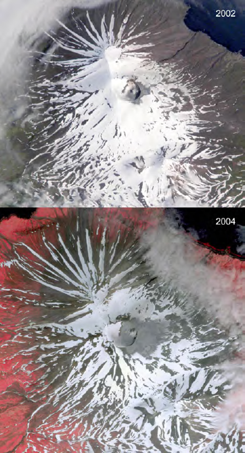 |
Figure 8. Two satellite photographs showing ash deposits on the upper E flank of Korovin in 2002 (top) and 2004 (bottom). The source of these ash deposits is thought to be intermittent, minor phreatic eruptions through the hot, roiling lake within the SE summit crater of Korovin (McGimsey and others, 2007). Top image was taken on 5 July 2002 and produced by the Image Analysis Laboratory, NASA Johnson Space Center. Bottom image was captured on 4 July 2004 and is an Ikonos near-infrared color composite, copyrighted by Space Imaging LLC. Both images originally published in McGimsey and others (2008). |
Activity during 1998-2007. During this interval (table 1), activity ranged from eruptive cases to those that were considered non eruptive.
Activity was often reported to AVO by Atka village residents and pilots in the area. Korovin was also monitored through satellite imagery, when weather conditions were favorable. During this interval, the highest plumes were observed on 30 June 1998 and reached an altitude of ~9.1 km. As activity varied, the Aviation Color Code (ACC), the Volcanic Activity Alert Level (VAAL), and the Level of Concern Color Code (LCCC) were changed to reflect Korovin's activity status.
AVO presented general information on reported activity from 1998-2007 on their website. For each of the events within this interval, AVO cited information from several sources, some of which included the following: McGimsey and others (2003), which discussed activity in 1998; McGimsey and others (2008), which discussed 2005 activity; Neal and others (2009) that looked at 2006 activity; and McGimsey and others (2011) that detailed 2007 activity. AVO also referenced several past Bulletin reports, which highlighted Korovin activity (BGVN 23:06, and 31:02).
Our summary in table 1 summarizes the following: (1) the basic information on Korovin's activity from the AVO website and (2) additional information from some of AVO's cited references. Greater detail can be found on AVO's website and in their cited references.
Table 1. Condensed descriptions of key events during both eruptive and non-eruptive periods during 1987-2007. The data sources are stated in the table. The Remarks column generally contains the following: (1) "AVO:" This presents a very brief synopsis of the summary that AVO provides on each of their Korovin reported activity web pages (as accessed in May 2015). (2) Below that, we present a succinct timeline of Korovin activity created using on information found in some of AVO's cited references. The 2005 activity is in two sections to highlight different periods of activity during that year; 2006-2007 is considered one period of activity. Where AVO cited references are augmented by past Bulletin reports, the information has been [bracketed]. Times are all local, unless otherwise stated. The term 'resident(s)' refers to resident(s) of Atka village. Abbreviations used are as follows: Village Public Safety Officer, VPSO; above sea level, a.s.l., and Interferometric synthetic aperture radar, InSAR; Aviation Color Code, ACC; Volcanic Activity Alert Level, VAAL; Level of Concern Color Code, LCCC; unassigned activity (UA); and satellite-based Ozone Monitoring Instrument, OMI.
| Date | Remarks |
| 1998 |
AVO: Eruption started, 30 June 1998 ±1 month. Eruption end, 30 June 1998 ± 7 days McGimsey and others (2003): Eruption start / stop dates: 30 June / 8 July "…, the timing of this activity remains poorly constrained; intermittent ash may, in fact, have occurred weeks or prior to June 30." 10 May- Pilot observed ash on SE slope. Pilot had seen no ash the previous week and speculated the ash was deposited a few days prior to May 10 28 June-Individual reported a dark ash plume over Korovin 30 June-VPSO in Atka village reported two separate clouds, first at ~0730 and second at ~0830. Second cloud rose ~9.1 km and was tinted orange. VPSO said events "produced dustings of ash in Atka". AVO received 2 pilot reports: (1) at 1115, noted volcanic cloud reached ~4.9 km a.s.l., (2) at 1720, cloud to 9.1 km near Korovin 2 July- Resident reported a 'rusty' cloud, ~4.9 km a.s.l. moving SE 3 July- Pilot reported profuse steam from summit crater and ash on S, SE and E flanks. Thin trail of ash extended SW towards Atka village 8 July- AVO noted minor, weakly ash-bearing clouds over Korovin with satellite images |
| 2002 |
AVO: Eruption started, July 2002 ±1 month. Considered a questionable eruption McGimsey and others (2008): 5 July- Satellite photo of ash deposits on upper E flank of Korovin (figure 8, top). "Intermittent, minor phreatic eruptions through a hot, roiling lake in the south summit crater of Korovin [is] the probable source." |
| 2004 |
AVO: Eruption started, June 2004 ±1 month. Considered a questionable eruption McGimsey and others (2008): 4 July- Satellite photograph shows ash deposits on upper E flank of Korovin (figure 8, bottom). Same explanation as 5 July 2002 Neal and others (2009): 7 July- Korovin photographed with ash covering the snow on its E flank. According to the caption of the photograph, "The deposit may be the result of phreatic explosions or vigorous wind remobilization of ash from within the summit crater." 19 July- Aerial photograph of Korovin showing ash deposited around the crater vent. The caption for the photograph states, "At times, a shallow body of gray, turbid water partially fills the inner crater and, in 2004, was observed roiling. Phreatic explosions from this water-rich, high-temperature system may be responsible for the occasional localized ash-fall deposits seen on the upper flanks of Korovin." |
| 2005 |
AVO: Eruption started, 23 February. Eruption end, 7 May ± 14 days. Considered a questionable eruption. McGimsey and others (2008): 23 February- Clear day. Residents noted minor steaming around 1200. Around 1900, residents observed dark cloud rising several thousand feet and drifting E (figure 6). Ash seen falling out near base of plume. Minutes later, three or four smaller gray puffs seen. No other activity seen that night. In satellite imagery, small steam plume with minor ash noticed. Height of plume estimated at ~3 km. 24 February- LCCC was raised from UA (unassigned) to Yellow 4 March- LCCC reduced from Yellow to UA 19 March- Pilot report noted steam rising several thousand feet above Korovin Early May- Observational data showed roiling lake in SE crater emptied. Visible glow. |
| 2005 |
AVO: Seismicity without confirmed eruption, start / end: 13 September McGimsey and others (2008): 13 September- Long sequence of strong seismicity. Sequence began with two small local events, then ~30 minutes of weak tremor, and then ~20 weak local events. Nothing unusual noted in satellite images from this time. |
| 2006-2007 |
AVO: Non-eruptive activity started, 16 January 2006 and ended September 2007 ± 2 months. Neal and others (2009): 16 January 2006- Background seismic activity increased 17-18, 21 Jan and 21-22 Feb- burst of tremor-like signals 22 February 2006- LCCC increased from Green to Yellow Early March- Seismicity stabilized and then decreased 8 March- LCCC downgraded from Yellow to Green July- Increased number of earthquakes in vicinity of Korovin September and October- Increased tremor episodes 19 October- SE crater lake disappeared by this date and absent for rest of 2006. Lake present on 12 September (satellite data). 29 October- White vapor plumes rose several hundred meters above Korovin and coincided with ~5-min of strong tremor 5 November 2006- Strongest earthquake swarm recorded by seismic network 6 November- Yellow ACC and an Advisory VAAL declared 18 November- dark-gray ash on E flank of SE crater observed in ASTER satellite images. Ash was not present in image from 21 November. ASTER satellite imagery showed warm spots in Korovin crater Late November 2006- Significant deformation in latter half of 2006. Circular pattern of uplift, as much as 5 cm noted through July and October InSAR data. November-December- Seismicity high; strong, short-lived signals. Low-frequency tremor bursts. 11, 21 and 24 December 2006- Residents photographed large, white-vapor plumes rising from Korovin. One resident noted that he saw ash falling below the plume he reported. Ash was not verified on the ground End of 2006-No ash detected in atmosphere or on ground through satellite data. Rise in ground temperature also not detected McGimsey and others (2011): Beginning of 2007- ACC, Yellow, and VAAL, Advisory due to increased activity in 2006. High seismicity from 2006 continued into 2007. Inflation (uplift) in N part of Atka Island that began in June 2006 totaled 9-10 cm and began to taper off in 2007 11 January 2007- M3.5 earthquake considered large for volcano-generated seismicity. 23 January- Series of tremor bursts 24 January- Resident took pictures of steam column rising from SE crater and reported similar steam columns rose ~300 m every 15-80 minutes 14 February 2007- Pilot reported a steam plume extending 1.5-2.4 km over Korovin 3 March- Residents photograph ash deposit on W flank. Residents observed steam from SE summit vent. Flurry of low-frequency seismicity in morning May, June & August- Episodes of tremor lasted several days 27 July 2007- Steam plumes observed by residents (figure 7) 5 August- OMI detected small SO2 cloud, 300 km N of Cleveland volcano. Based on wind dispersal models, cloud believed to be from Korovin. Aerial photo (figure 5) showed steam rising from SE crater 20 August- OMI detected small emission of SO2 from Korovin 7 September- ACC/VAAL downgraded to Green/Normal due to decreasing trends in seismicity and uplift October-December 2007- uneventful |
References. Alaska Volcano Observatory, the U.S. Geological Survey, BigTopo 7, and AllTopo 7, Topographic shaded relief image of the northern part of Atka Island (Image 2906), accessed on 14 April 2005, (URL: http://www.avo.alaska.edu/images/image.php?id=2906).
McGimsey, R. G., Neal, C. A., and Girina, O., 2003, 1998 volcanic activity in Alaska and Kamchatka: Summary of events and response of the Alaska Volcano Observatory: U.S. Geological Survey Open-File Report OF 03-0423, 35 pp, (URL: http://pubs.usgs.gov/of/2003/of03-423/).
McGimsey, R.G., Neal, C.A., Dixon, J.P., and Ushakov, S., 2008, 2005 Volcanic activity in Alaska, Kamchatka, and the Kurile Islands: Summary of events and response of the Alaska Volcano Observatory: U.S. Geological Survey Scientific Investigations Report 2007-5269, 94 pp, (URL: http://pubs.usgs.gov/sir/2007/5269/).
McGimsey, R.G., Neal, C.A., Dixon, J.P., Malik, N., and Chibisova, M., 2011, 2007 Volcanic activity in Alaska, Kamchatka, and the Kurile Islands: Summary of events and response of the Alaska Volcano Observatory: U.S. Geological Survey Scientific Investigations Report 2010-5242, 110 pp, (URL: http://pubs.usgs.gov/sir/2010/5242/).
Myers, J.D., Marsh, B. D., Frost, C. D. and Linton, J.A., 2002, Petrologic constraints on the spatial distribution of crustal magma chambers, Atka Volcanic Center, central Aleutian arc, Contributions to Mineralogy and Petrology, vol. 143, issue 5, pp. 567-586, DOI 10.1007/s00410-002-0356-7 (URL: http://link.springer.com/article/10.1007/s00410-002-0356-7).
Neal, C.A., McGimsey, R.G., Dixon, J.P., Manevich, A., and Rybin, A., 2009, 2006 Volcanic activity in Alaska, Kamchatka, and the Kurile Islands: Summary of events and response of the Alaska Volcano Observatory: U.S. Geological Survey Scientific Investigations Report 2008-5214, 102 pp, (URL: http://pubs.usgs.gov/sir/2008/5214/).
Information Contacts: Alaska Volcano Observatory (AVO), a cooperative program of a) U.S. Geological Survey, 4200 University Drive, Anchorage, AK 99508-4667, USA (URL: http://www.avo.alaska.edu/), b) Geophysical Institute, University of Alaska, PO Box 757320, Fairbanks, AK 99775-7320, USA, and c) Alaska Division of Geological & Geophysical Surveys, 794 University Ave., Suite 200, Fairbanks, AK 99709, USA; Game McGimsey, AVO.
2025: February
| April
2024: March
| April
2023: March
2021: August
2020: October
| December
2006: February
| March
| November
2005: February
| March
At 1200 on 5 May the Alaska Volcano Observatory (AVO) lowered the Volcano Alert Level for the Atka volcanic complex to Normal (the lowest level on a four-level scale) and the Aviation Color Code to Green (the lowest color on a four-color scale). AVO noted that no additional explosive activity was recorded after the small explosive event at 1034 on 25 April.
Source: US Geological Survey Alaska Volcano Observatory (AVO)
A small, short-lived explosion from the summit of Korovin, one of the volcanoes at the Atka volcanic complex, was detected at 1034 on 25 April, prompting the Alaska Volcano Observatory (AVO) to raise the Volcano Alert Level to Advisory (the second lowest level on a four-level scale) and the Aviation Color Code to Yellow (the second lowest color on a four-color scale). High weather clouds obscured views at the time of the explosion, preventing confirmation of the event in satellite observations. Similar past events at the Atka complex did not result in ash emissions of noticeable ashfall. No further activity was detected during 26-29 April; seismicity was low and weather clouds obscured webcam and satellite views.
Source: US Geological Survey Alaska Volcano Observatory (AVO)
The Alaska Volcano Observatory (AVO) reported that no additional explosions at the Atka volcanic complex were detected after the small explosion recorded at 1926 on 20 February. Several small daily earthquakes were detected during 21 February-3 March, though at a decreasing frequency through the week; seismicity was characterized as low. No ash deposits from the February 20 explosive event were visible in clear satellite views. Webcam views showed occasional steam emissions throughout the week. At 1452 on 3 March the Volcano Alert Level was lowered to Normal (the lowest level on a four-level scale) and the Aviation Color Code was lowered to Green (the lowest color on a four-color scale).
Source: US Geological Survey Alaska Volcano Observatory (AVO)
A small explosion from the summit lake region of Korovin, one of the volcanoes at the Atka volcanic complex, was detected at 1926 on 20 February, prompting the Alaska Volcano Observatory (AVO) to raise the Volcano Alert Level to Watch (the second highest level on a four-level scale) and the Aviation Color Code to Orange (the second highest color on a four-color scale). The event was brief (less than 10 seconds), probably phreatic, and likely ejected a small amount of ash that was deposited within the immediate vicinity of the lake, though ash was unconfirmed. A meteorological cloud deck at altitudes of 2.4-3 (8,000-10,000 ft) a.s.l. obscured direct satellite observations, but no ash emissions were observed above the clouds. Satellite data acquired later that evening showed no evidence of hot material at the surface. There were no further explosive events detected and no noticeable change in seismic activity; at 1114 on 21 February AVO lowered the Volcano Alert Level to Advisory and the Aviation Color Code to Yellow. This type of singular explosion was common at Korovin. Several small local seismic events were detected during 21-23 February, though the overall level of seismicity was very low. Satellite and webcam observations were obscured by weather clouds.
Source: US Geological Survey Alaska Volcano Observatory (AVO)
AVO lowered the Volcano Alert Level for the Atka volcanic complex to Normal (the lowest level on a four-level scale) and the Aviation Color Code to Green (the lowest color on a four-color scale) at 0734 on 9 April. The report noted that activity at the volcano had decreased following the small explosion at the summit crater of Korovin on 27 March, one of the volcanoes at the complex. Though occasional small earthquakes and weak volcanic tremor continued to be recorded, the activity was at background levels.
Source: US Geological Survey Alaska Volcano Observatory (AVO)
A small, brief, explosion at summit crater of Korovin, one of the volcanoes at the Atka volcanic complex, was detected at 1936 on 27 March, prompting AVO to raise the Volcano Alert Level to Advisory (the second level on a four-level scale) and the Aviation Color Code to Yellow (the second color on a four-color scale). The event was recorded in local infrasound and seismic data and was followed by a few minutes of elevated seismic tremor. Low-frequency earthquakes and periods of seismic tremor were detected during 30 March-1 April. Satellite and web-camera views were mostly obscured by clouds through 1 April, though no significant ash deposits were visible in a few clear images.
Source: US Geological Survey Alaska Volcano Observatory (AVO)
On 2 March AVO changed both the Aviation Color Code and Volcano Alert Level for the Atka Volcanic Complex to Unassigned, due to a data outage. The loss of data flow from seismic stations made AVO unable to assess whether the volcano is at its normal background state.
Source: US Geological Survey Alaska Volcano Observatory (AVO)
AVO lowered the Aviation Color Code and Volcano Alert Level for the Atka Volcanic Complex to Green and Normal, respectively, on 27 August, noting that seismicity had returned to baseline levels over the previous week.
Source: US Geological Survey Alaska Volcano Observatory (AVO)
AVO reported that small earthquakes and seismic tremors at Atka continued to be detected, though at near background levels during 18-24 August. The Aviation Color Code remained at Yellow and the Volcano Alert Level at Advisory.
Source: US Geological Survey Alaska Volcano Observatory (AVO)
The number of small shallow earthquakes increased at Atka during 10-11 August, prompting AVO to raise the Aviation Color Code to Yellow and the Volcano Alert Level to Advisory. The earthquakes were located at a depth of 3-6 km and around 7 km SW of Korovin, though may be related to the several vents that are part of the Atka volcanic complex. Seismicity declined afterwards but remained above background levels through 16 August, and was near baseline levels by 17 August.
Source: US Geological Survey Alaska Volcano Observatory (AVO)
Seismic activity at Korovin had decreased, and satellite images showed no signs of unrest over the previous several weeks. AVO lowered the Alert Level to Green and the Aviation Color Code to Normal on 3 December.
Source: US Geological Survey Alaska Volcano Observatory (AVO)
On 28 October AVO raised the Aviation Color Code and Volcano Alert Level for Korovin to Yellow and Advisory, respectively, noting that activity was above background levels. Discrete earthquakes were detected over the previous two weeks and sulfur dioxide emissions were identified four times in satellite data on 15, 20, and 26 October. Low-level seismicity continued and no surficial activity was evident in cloudy or partly cloudy satellite images through 3 November.
Source: US Geological Survey Alaska Volcano Observatory (AVO)
The number of daily earthquakes increased in July and remained elevated into November. Episodes of volcanic tremor that first occurred in September increased in number, strength, and duration in the past several weeks. On 28 October, residents of Atka observed steam emissions to many hundreds of meters above the summit. On 6 November, the AVO raised the Aviation Level of Concern Color Code to Yellow and the Volcanic Alert Level to Advisory due to the high seismicity and steam emissions.
Source: US Geological Survey Alaska Volcano Observatory (AVO)
AVO decreased the Concern Color Code at Korovin from Yellow to Green (the lowest level) on 8 March. After raising the Concern Color Code on 22 February in response to increased seismicity, the rate of micro-earthquakes stabilized and then declined. During 1-8 March, seismicity was near background levels and no unusual activity was seen on satellite imagery or by observers.
Source: US Geological Survey Alaska Volcano Observatory (AVO)
Seismicity at Korovin remained slightly above background levels during 24 February to 3 March. Clouds obscured satellite views of the volcano, and AVO received no reports of activity. There were no indications that an eruption was imminent. The volcano remained at Concern Color Code Yellow.
Source: US Geological Survey Alaska Volcano Observatory (AVO)
AVO reported that the Concern Color Code at Korovin volcano was raised from Green to Yellow on 22 February due to an increase in seismicity at the volcano. Distinct seismic signals indicating unrest were recorded on 4 days between 17 and 22 January, with a sustained 11-minute-long seismic signal on 22 February. After 22 February, seismicity decreased and distinct seismic signals like those recorded earlier were not detected. Clouds obscured satellite views of the volcano after 22 February. A pilot report on the 22nd indicated that the summit area was obscured by clouds, and there were no signs of ashfall on the flanks and no steam plume above the volcano. No obvious signs of activity were seen on 23 February by observers in the village of Atka. AVO received no reports of volcanic activity and there were no indications that an eruption was imminent.
Source: US Geological Survey Alaska Volcano Observatory (AVO)
AVO did not receive reports of activity at Korovin volcano after the original report of ash-and-steam emissions on 24 February. During 25 February to 4 March, cloud cover prohibited satellite views of the volcano and no unusual seismicity was registered. Korovin is not monitored by a standard AVO seismic network. Therefore, AVO did not assign a Concern Color Code to the volcano during the report period.
Source: US Geological Survey Alaska Volcano Observatory (AVO)
On 24 February AVO raised the Concern Color Code at Korovin volcano from Green to Yellow after receiving a report that ash and steam were emitted from Korovin on 23 February around 1900. According to residents of Atka village near the volcano, the initial ash burst rose to a height of ~ 2.4 km a.s.l. and drifted E. It was followed by several smaller ash-and-steam bursts. No ashfall was reported in Atka village, nor were there reports of accompanying volcanic odors, earthquakes, or larger volcanic explosions. Satellite images of the volcano did not clearly show the presence of ash or any thermal anomalies. On the morning of 24 February the volcano was steaming. AVO warned that low-level steam-and-ash emissions may continue and could pose a hazard to people and low- to medium-flying aircraft in the vicinity of the volcano. They further warned that if the eruption continues and begins to intensify, light ash fall could occur on parts of Atka Island, including the village of Atka.
Source: US Geological Survey Alaska Volcano Observatory (AVO)
Reports are organized chronologically and indexed below by Month/Year (Publication Volume:Number), and include a one-line summary. Click on the index link or scroll down to read the reports.
Steam emission follows magnitude 7.7 earthquake
[On 6 May], James Dickson noted a 500-m vertical steam plume over the SE part of the summit [of Korovin]. On 23 May at about 1730, Aleutian Air pilot Thomas Madsen noted a 600-m steam plume containing traces of ash rising above the rim of a 240-m-deep crater in the SE part of the summit area. A shallow magnitude 7.7 earthquake centered roughly 100 km [SSW] of Korovin at [51.52°N, 174.78°W] occurred 7 May [at 2247 GMT].
John Reeder and Kirk Swanson climbed [Korovin] in July 1983, observing only minor steaming from deep within the crater, rising to only 60 m above its floor.
Information Contacts: J. Reeder, ADGGS; T. Miller and M.E. Yount, USGS Branch of Alaskan Geology, Anchorage.
Ash eruption from Korovin summit and two nearby vents
On 18 March at 1954 a NOAA 10 satellite image showed three distinct plumes, each 95 km long, drifting ENE. The estimated vent locations were: 52.38°N, 174.15°W (Korovin's summit); 52.31°N, 174.24°W; and 52.29°N, 174.21°W (5.5 km WSW and 6.5 km SW of Mt. Kliuchef, a cone on Korovin's S flank). More accurate locations will be determined by USGS Anchorage. Just before midnight on the same day US Navy pilot Jeffrey Sullivan observed a southward-drifting ash plume rising to at least 3,000 m altitude, lit by an orange "flame" from Korovin. Smaller orange flickering "flames" from two other vents at lower elevation were visible. Two of the vents were ~2 km apart and the third vent was ~10 km NE of the other two vents.
Earlier in the day (at 1300) Julie Dirks and other Atka residents noticed sulfur smells (~18 km from the volcano). Although the weather was clear Dirks did not notice any "unusual" eruptive activity. On 19 March a SIGMET notice was issued to warn pilots of volcanic ash 185 km on either side of a line from 52°N, 175°W to 54°N, 172°W. The warning remained in effect until 0930. Pilots reported that the ash cloud reached 3,600 m.
Information Contacts: J. Reeder, ADGGS; M. Matson, NOAA/NESDIS; T. Miller, USGS, Anchorage.
"Rumbling" and degassing accompanies M 5.1 earthquake
On 10 December AVO reported the following. "On 4 December, following a M 5.1 earthquake at 1836 beneath the . . . island of Atka, residents of Atka village reported "rumbling" from the cluster of volcanoes that forms the N part of the island. At the same time, residents observed increased steaming from a fumarolic area on the flank of Kliuchef volcano and noted a distinct sulphur smell. A check of satellite imagery did not confirm any change in the surface state of the volcanoes. Late this week, the weather had deteriorated and no visual observations of the volcanoes were possible. . . ."
Information Contacts: AVO.
Small plume-like cloud over Kliuchef and very strong sulfur smell
Observers in the village of Atka on Atka Island in the central Aleutians reported a very strong sulfur smell on 1 May, and to a lesser extent on 4 May when they observed a small plume-like cloud over Kliuchef. Fumarolic areas exist on or near both Korovin and Kliuchef volcanoes, N of the village. Korovin was active most recently in 1987, and Kliuchef has had Holocene activity. Satellite images did not reveal any plume-like clouds associated with the island, however, a "hot-spot" possibly of fumarolic areas, was observed. A similar sulfur smell was reported by residents in December 1993, at about the same time they felt rumbling from a M 5.1 earthquake (BGVN 18:11).
Information Contacts: Alaska Volcano Observatory (AVO), a cooperative program of a) U.S. Geological Survey, 4200 University Drive, Anchorage, AK 99508-4667 USA, b) Geophysical Institute, University of Alaska, PO Box 757320, Fairbanks, AK 99775-7320, USA, and c) Alaska Division of Geological & Geophysical Surveys, 794 University Ave., Suite 200, Fairbanks, AK 99709, USA.
Eruption of volcanic ash
On 29 June, Japan Airlines reported volcanic ash erupting from Atka. In addition, GEOS-9 satellite images showed a possible small ash cloud in the immediate vicinity of Atka. In early May 1995 residents of Atka village observed a small plume-like cloud over Kliuchef and reported a strong sulfur smell (BGVN 20:05).
[The 1996 eruption described here was later discredited.]
Information Contacts: Alaska Volcano Observatory (AVO), a cooperative program of a) U.S. Geological Survey, 4200 University Drive, Anchorage, AK 99508-4667, USA, b) Geophysical Institute, University of Alaska, PO Box 757320, Fairbanks, AK 99775-7320, USA, and c) Alaska Division of Geological & Geophysical Surveys; NOAA/NESDIS Synoptic Analysis Branch (SAB), Room 401, 5200 Auth Road, Camp Springs, MD 20746, USA.
Low eruption plume seen in June, dusting of ash in Atka
At about 1000 on 30 June, the Alaska Volcano Observatory (AVO) received a report of an eruption at Korovin from an observer in the village of Atka, near the volcano. The crew of a Coast Guard C-130 airplane confirmed that a low-level eruption plume had risen to almost 5 km above sea level by 1030, and late in the afternoon a pilot reported the plume at 9 km. The low-level ash-and-steam plume was not visible on satellite imagery due to meteorological clouds. Local winds at the time were light and to the SSW. A dusting of ash was reported in Atka. Poor weather on 1 July prohibited both direct and satellite observations.
Korovin volcano is located on the north end of Atka Island in the central Aleutians (figure 1), 538 km W of Dutch Harbor. It is 21 km N of the village of Atka, which has a population of about 100. The last reported eruption was in March 1987. AVO does not maintain seismic monitoring equipment on Atka Island.
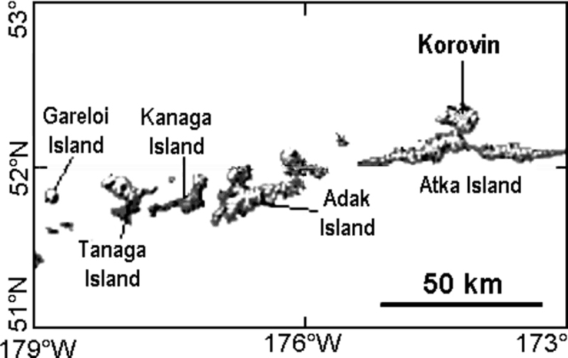 |
Figure 1. Location of Korovin [Atka] volcano in the Aleutians. Map courtesy of AVO. |
Information Contacts: Alaska Volcano Observatory (AVO), a cooperative program of a) U.S. Geological Survey, 4200 University Drive, Anchorage, AK 99508-4667, USA (URL: http://www.avo.alaska.edu/), b) Geophysical Institute, University of Alaska, PO Box 757320, Fairbanks, AK 99775-7320, USA, and c) Alaska Division of Geological & Geophysical Surveys, 794 University Ave., Suite 200, Fairbanks, AK 99709, USA.
Small steam-and-ash eruption on 23 February 2005 at Korovin
[What follows is a corrected report taking advantage of new information.]
2005 activity. The Alaska Volcano Observatory (AVO) received a report that a sudden minor steam-and-ash eruption occurred at Korovin around 1900 on 23 February [2005]. Korovin is an active volcano ... in the central Aleutian islands, ~ 184 km E of Adak island and ~ 600 km W of Unimak island, and 1,760 km SW of Anchorage. According to residents of Atka village near Korovin, the initial ash burst rose to an altitude of ~ 2.4 km and drifted E. It was followed by several smaller ash-and-steam bursts.
No ashfall was reported in Atka village, nor were there reports of accompanying volcanic odors, earthquakes, or larger volcanic explosions. Satellite images of the volcano did not clearly show the presence of ash or any thermal anomalies. But, on the morning of 24 February [2005] (the morning after the eruption) the volcano was still steaming with some vigor. During the period 25 February-4 March [2005], cloud cover prohibited satellite views of the volcano, and no unusual seismicity registered.
Although Korovin was not monitored by a standard AVO seismic network, Atka village hosts a seismic station operated by the Alaska Earthquake Information Center. [No activity was reported following the 23 February 2005 eruption until January 2006].
2006 activity. Distinct seismic signals indicating unrest were recorded on 17, 18, and 21 January 2006, and 21 and 22 February 2006. The latter day (22nd) brought an unusually sustained, 11-minute-long signal.
After 22 February 2006, seismicity decreased and distinct seismic signals like those recorded earlier were not detected. An 8 March report noted that Korovin's rate of occurrence of micro-earthquakes had stabilized and then declined, and "it has been close to background levels for the past week."
For some days after 22 February, clouds obscured satellite views of the volcano. However, on the 22nd an aviator reported that, although the summit area was obscured by clouds, no signs of ashfall on the flanks or any steam plume was seen. On 23 February, observers in the village of Atka noted the lack of obvious signs of activity. AVO received no short-term reports of precursory volcanism to indicate an imminent eruption.
Seismicity at Korovin remained slightly above background levels during 24 February to 3 March 2006. Clouds continued to mask satellite views of the volcano, and AVO received no further reports of activity.
Information Contacts: Alaska Volcano Observatory (AVO), a cooperative program of the U.S. Geological Survey, 4200 University Drive, Anchorage, AK 99508-4667, USA (URL: http://www.avo.alaska.edu/), Geophysical Institute, University of Alaska, PO Box 757320, Fairbanks, AK 99775-7320, USA, and Alaska Division of Geological & Geophysical Surveys, 794 University Ave., Suite 200, Fairbanks, AK 99709, USA.
Minor plumes bearing steam and ash throughout November-December 2006
[What follows is a corrected report taking advantage of new information.]
2005 activity. Korovin... has been relatively quiet since 23 February [2005], when it emitted minor though abruptly discharged steam and ash (BGVN 31:02). At that time, an initial ash burst rose to an altitude of ~ 2.4 km and was followed by several smaller ash-and-steam bursts, but no ashfall was reported in Atka village (figure 2). There were no reports of accompanying volcanic odors, earthquakes, or larger volcanic explosions.
Early 2006 activity. Earlier this year, seismicity indicating unrest was noted in January and February (BGVN 31:02). From 24 February-3 March 2006, seismicity at Korovin was slightly above background levels. During that time frame, the Alaska Volcano Observatory (AVO) raised the concern color code at Korovin from Green to Yellow. The concern color code was then but reduced it to Green on 8 March 2006 .
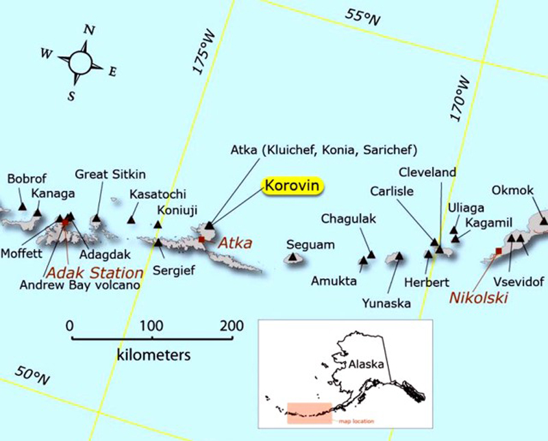 |
Figure 2. Sketch map of the central Aleutian Islands including Atka Island and the city of Atka (population 27, according to 1999 US Census estimate). Courtesy of USGS/AVO. |
Late 2006 activity. An increase in seismicity during July 2006 represented a transition from prior low activity, meanwhile volcanic activity remained mild during that time (figure 3).
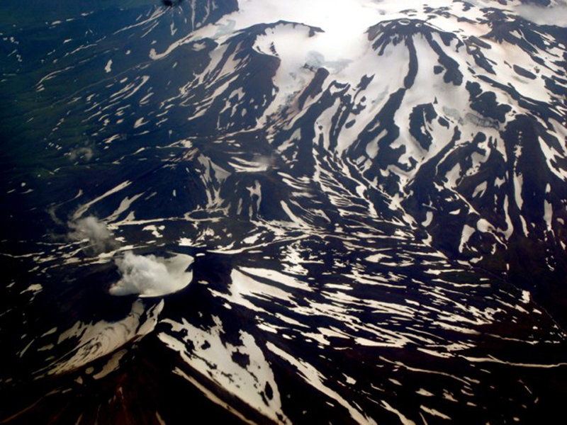 |
Figure 3. The Korovin cone (lower left) in the Atka volcanic center was puffing steam to ~ 300 m above the summit on 30 July 2006 when seen from an Alaska Airlines jet. The Kliuchef cone (upper right, with two snow-clad craters) is one of multiple satellite cones. Photo credit to Cyrus Read; image courtesy of AVO/USGS. |
This report also covers further minor events during September through December. During September and October, episodes of volcanic tremor increased in number, strength, and duration. On 28 October, residents of Atka village observed and photographed steam emissions to several hundred meters above the volcano.
For the duration of November and December, seismic levels remained above background levels. In late November satellite information showed a light dusting of ash on the E flank of the main crater along with several plumes and/or their shadows visible along the N side of the crater. Satellite radar images indicated uplift of the volcano; the area of uplift was consistent with locations of earthquake activity and the effects were interpreted as the result of magma injection. Cloud cover permitted only erratic satellite observation during November and December. On 11 and 21 December 2006, Atka residents again witnessed steam plumes, on the latter date possibly containing ash.
Information Contacts: Alaska Volcano Observatory (AVO), a cooperative program of the U.S. Geological Survey, 4200 University Drive, Anchorage, AK 99508-4667, USA (URL: http://www.avo.alaska.edu/), Geophysical Institute, University of Alaska, PO Box 757320, Fairbanks, AK 99775-7320, USA, and Alaska Division of Geological & Geophysical Surveys, 794 University Ave., Suite 200, Fairbanks, AK 99709, USA.
Summary of activity during 1998-2007
Korovin is a stratovolcano located on Atka Island in the central Aleutian Islands; its most recent reported activity ended in 2007. This report summarizes and contains new information on activity from 1998 to 2007 by drawing on information primarily from the Alaska Volcano Observatory (AVO) and their cited publications. Much of the summary takes the form of a table at the end of the report.
Atka volcanic complex. According to Myers and others (2002) Korovin is a part of the 360 km2 Atka volcanic complex, found on the northern part of Atka Island. It is the largest modern complex within the central Aleutians (Myers and others, 2002). The ancestral Atka volcano, in the complex, was described as a large shield volcano consisting of basaltic and basaltic andesite flows, which was subsequently surrounded by a series of satellite vents (Myers and others, 2002).
A caldera forming eruption at the Atka shield volcano occurred ~300,000-500,000 years ago, creating a 5-km-diameter caldera. Associated with that event was the eruption of a large dacitic flow, called Big Pink. Regarding the composition of Big Pink, Myers and others (2002) said, "It consists of pumiceous and glassy units but is not associated with any ash flows." After the caldera formation, the volcanic centers of Korovin, Kliuchef, Konia and Sarichef formed. Figure 4 is a topographic map showing the location of these four volcanic centers and the location of the Atka caldera. These structures all comprise the Atka volcanic complex.
|
Figure 4. Topographical map of the northern part of Atka Island, located in the central Aleutian Islands. The map highlights the locations of the Atka caldera, the Korovin, Kliuchef and Sarichef volcanoes and the Konia vent, which all comprise the Atka volcanic complex. Image created by the Alaska Volcano Observatory (AVO) and U.S Geological Survey (USGS) using BigTopo 7 software and AllTopo 7. Image taken from the AVO website. |
Korovin volcano. Korovin is located 21 km NE from the town of Atka (figure 4). It is the largest and tallest volcano of the post-caldera volcanic centers within the Atka volcanic complex. According to Myers and others (2002), Korovin shows little evidence of glaciation, unlike Kliuchef, located ~5 km S of Korovin. Regarding Korovin' edifice and age, Myers and others (2002) say "Its uneroded form suggests the volcano is mostly Holocene in age."
Korovin has a basal diameter of ~7 km and two summit vents located 0.6 km apart (Myers and others, 2002). The NW summit vent has a small crater and is the lower of the two vents. The SE summit has a 1 km wide crater, with steep walls and a depth of several hundred meters (Myers and others, 2002). The SE summit crater sometimes contains a crater lake and is considered Korovin's active crater. Figure 5 is an aerial photo of Korovin, highlighting its two summit vents.
|
Figure 5. Photograph of Korovin volcano taken from an aircraft flying at 9.1 km altitude on 5 August 2007. The view is oblique and from the N (i.e. looking S). Steam is rising from the active crater (SE crater). The summit of Kliuchef volcano is partially visible at the top of the image; it sits ~5 km S of Korovin. Photograph taken by Burke Mees, Alaska Airlines. Photograph from McGimsey and others (2011). |
During the summer of 2004, AVO installed a network of seismic stations throughout the northern part of Atka Island. Data from the network was accessible in March 2005; however, it wasn't until December 2005 that Korovin was considered seismically monitored. On 2 December 2005, Korovin was also officially assigned the Level of Concern Color Code Green after "a sufficient period of background seismicity had been recorded" (McGimsey and others, 2007). Before, AVO had listed Korovin as UA (unassigned) during periods when no significant activity was noted. AVO assigns volcanoes UA when there is no real-time seismic network in the area that can be used to define background levels of seismicity.
In addition to being seismically monitored, Korovin is also monitored through ground-based, aerial, and satellite imagery and photographs. Korovin and its plumes are often photographed by residents of Atka village (figures 6 and 7), which are then sent to the AVO. Figure 8 provides examples of photos of Korovin taken from satellites. Images from figures 6-8 furnish various kinds of evidence, from steaming (i.e. non-eruptive cases, figure 7), ash-bearing plumes (figure 6), and the result of ash-bearing eruptions (ash on the snow surface seen in satellite views, figure 8). Evidence of these kinds is summarized in next section.
|
Figure 6. Photographs showing the progression of a steam plume that developed over Kovorin around 1900 on 23 February 2005. Plume was observed drifting to the E, and ash was seen falling out near the base of the plume. These photos were taken in Atka village and are courtesy of Louis and Kathleen Nevzoroff. Photos were taken from McGimsey and others (2008). |
|
Figure 7. Photograph of a steam column rising from Korovin on 27 July 2007. Steam was estimated to reach ~215-245 m above the crater. The photo was captured by Louis Nevzoroff from Atka village. Taken from McGimsey and others (2011). |
|
Figure 8. Two satellite photographs showing ash deposits on the upper E flank of Korovin in 2002 (top) and 2004 (bottom). The source of these ash deposits is thought to be intermittent, minor phreatic eruptions through the hot, roiling lake within the SE summit crater of Korovin (McGimsey and others, 2007). Top image was taken on 5 July 2002 and produced by the Image Analysis Laboratory, NASA Johnson Space Center. Bottom image was captured on 4 July 2004 and is an Ikonos near-infrared color composite, copyrighted by Space Imaging LLC. Both images originally published in McGimsey and others (2008). |
Activity during 1998-2007. During this interval (table 1), activity ranged from eruptive cases to those that were considered non eruptive.
Activity was often reported to AVO by Atka village residents and pilots in the area. Korovin was also monitored through satellite imagery, when weather conditions were favorable. During this interval, the highest plumes were observed on 30 June 1998 and reached an altitude of ~9.1 km. As activity varied, the Aviation Color Code (ACC), the Volcanic Activity Alert Level (VAAL), and the Level of Concern Color Code (LCCC) were changed to reflect Korovin's activity status.
AVO presented general information on reported activity from 1998-2007 on their website. For each of the events within this interval, AVO cited information from several sources, some of which included the following: McGimsey and others (2003), which discussed activity in 1998; McGimsey and others (2008), which discussed 2005 activity; Neal and others (2009) that looked at 2006 activity; and McGimsey and others (2011) that detailed 2007 activity. AVO also referenced several past Bulletin reports, which highlighted Korovin activity (BGVN 23:06, and 31:02).
Our summary in table 1 summarizes the following: (1) the basic information on Korovin's activity from the AVO website and (2) additional information from some of AVO's cited references. Greater detail can be found on AVO's website and in their cited references.
Table 1. Condensed descriptions of key events during both eruptive and non-eruptive periods during 1987-2007. The data sources are stated in the table. The Remarks column generally contains the following: (1) "AVO:" This presents a very brief synopsis of the summary that AVO provides on each of their Korovin reported activity web pages (as accessed in May 2015). (2) Below that, we present a succinct timeline of Korovin activity created using on information found in some of AVO's cited references. The 2005 activity is in two sections to highlight different periods of activity during that year; 2006-2007 is considered one period of activity. Where AVO cited references are augmented by past Bulletin reports, the information has been [bracketed]. Times are all local, unless otherwise stated. The term 'resident(s)' refers to resident(s) of Atka village. Abbreviations used are as follows: Village Public Safety Officer, VPSO; above sea level, a.s.l., and Interferometric synthetic aperture radar, InSAR; Aviation Color Code, ACC; Volcanic Activity Alert Level, VAAL; Level of Concern Color Code, LCCC; unassigned activity (UA); and satellite-based Ozone Monitoring Instrument, OMI.
| Date | Remarks |
| 1998 |
AVO: Eruption started, 30 June 1998 ±1 month. Eruption end, 30 June 1998 ± 7 days McGimsey and others (2003): Eruption start / stop dates: 30 June / 8 July "…, the timing of this activity remains poorly constrained; intermittent ash may, in fact, have occurred weeks or prior to June 30." 10 May- Pilot observed ash on SE slope. Pilot had seen no ash the previous week and speculated the ash was deposited a few days prior to May 10 28 June-Individual reported a dark ash plume over Korovin 30 June-VPSO in Atka village reported two separate clouds, first at ~0730 and second at ~0830. Second cloud rose ~9.1 km and was tinted orange. VPSO said events "produced dustings of ash in Atka". AVO received 2 pilot reports: (1) at 1115, noted volcanic cloud reached ~4.9 km a.s.l., (2) at 1720, cloud to 9.1 km near Korovin 2 July- Resident reported a 'rusty' cloud, ~4.9 km a.s.l. moving SE 3 July- Pilot reported profuse steam from summit crater and ash on S, SE and E flanks. Thin trail of ash extended SW towards Atka village 8 July- AVO noted minor, weakly ash-bearing clouds over Korovin with satellite images |
| 2002 |
AVO: Eruption started, July 2002 ±1 month. Considered a questionable eruption McGimsey and others (2008): 5 July- Satellite photo of ash deposits on upper E flank of Korovin (figure 8, top). "Intermittent, minor phreatic eruptions through a hot, roiling lake in the south summit crater of Korovin [is] the probable source." |
| 2004 |
AVO: Eruption started, June 2004 ±1 month. Considered a questionable eruption McGimsey and others (2008): 4 July- Satellite photograph shows ash deposits on upper E flank of Korovin (figure 8, bottom). Same explanation as 5 July 2002 Neal and others (2009): 7 July- Korovin photographed with ash covering the snow on its E flank. According to the caption of the photograph, "The deposit may be the result of phreatic explosions or vigorous wind remobilization of ash from within the summit crater." 19 July- Aerial photograph of Korovin showing ash deposited around the crater vent. The caption for the photograph states, "At times, a shallow body of gray, turbid water partially fills the inner crater and, in 2004, was observed roiling. Phreatic explosions from this water-rich, high-temperature system may be responsible for the occasional localized ash-fall deposits seen on the upper flanks of Korovin." |
| 2005 |
AVO: Eruption started, 23 February. Eruption end, 7 May ± 14 days. Considered a questionable eruption. McGimsey and others (2008): 23 February- Clear day. Residents noted minor steaming around 1200. Around 1900, residents observed dark cloud rising several thousand feet and drifting E (figure 6). Ash seen falling out near base of plume. Minutes later, three or four smaller gray puffs seen. No other activity seen that night. In satellite imagery, small steam plume with minor ash noticed. Height of plume estimated at ~3 km. 24 February- LCCC was raised from UA (unassigned) to Yellow 4 March- LCCC reduced from Yellow to UA 19 March- Pilot report noted steam rising several thousand feet above Korovin Early May- Observational data showed roiling lake in SE crater emptied. Visible glow. |
| 2005 |
AVO: Seismicity without confirmed eruption, start / end: 13 September McGimsey and others (2008): 13 September- Long sequence of strong seismicity. Sequence began with two small local events, then ~30 minutes of weak tremor, and then ~20 weak local events. Nothing unusual noted in satellite images from this time. |
| 2006-2007 |
AVO: Non-eruptive activity started, 16 January 2006 and ended September 2007 ± 2 months. Neal and others (2009): 16 January 2006- Background seismic activity increased 17-18, 21 Jan and 21-22 Feb- burst of tremor-like signals 22 February 2006- LCCC increased from Green to Yellow Early March- Seismicity stabilized and then decreased 8 March- LCCC downgraded from Yellow to Green July- Increased number of earthquakes in vicinity of Korovin September and October- Increased tremor episodes 19 October- SE crater lake disappeared by this date and absent for rest of 2006. Lake present on 12 September (satellite data). 29 October- White vapor plumes rose several hundred meters above Korovin and coincided with ~5-min of strong tremor 5 November 2006- Strongest earthquake swarm recorded by seismic network 6 November- Yellow ACC and an Advisory VAAL declared 18 November- dark-gray ash on E flank of SE crater observed in ASTER satellite images. Ash was not present in image from 21 November. ASTER satellite imagery showed warm spots in Korovin crater Late November 2006- Significant deformation in latter half of 2006. Circular pattern of uplift, as much as 5 cm noted through July and October InSAR data. November-December- Seismicity high; strong, short-lived signals. Low-frequency tremor bursts. 11, 21 and 24 December 2006- Residents photographed large, white-vapor plumes rising from Korovin. One resident noted that he saw ash falling below the plume he reported. Ash was not verified on the ground End of 2006-No ash detected in atmosphere or on ground through satellite data. Rise in ground temperature also not detected McGimsey and others (2011): Beginning of 2007- ACC, Yellow, and VAAL, Advisory due to increased activity in 2006. High seismicity from 2006 continued into 2007. Inflation (uplift) in N part of Atka Island that began in June 2006 totaled 9-10 cm and began to taper off in 2007 11 January 2007- M3.5 earthquake considered large for volcano-generated seismicity. 23 January- Series of tremor bursts 24 January- Resident took pictures of steam column rising from SE crater and reported similar steam columns rose ~300 m every 15-80 minutes 14 February 2007- Pilot reported a steam plume extending 1.5-2.4 km over Korovin 3 March- Residents photograph ash deposit on W flank. Residents observed steam from SE summit vent. Flurry of low-frequency seismicity in morning May, June & August- Episodes of tremor lasted several days 27 July 2007- Steam plumes observed by residents (figure 7) 5 August- OMI detected small SO2 cloud, 300 km N of Cleveland volcano. Based on wind dispersal models, cloud believed to be from Korovin. Aerial photo (figure 5) showed steam rising from SE crater 20 August- OMI detected small emission of SO2 from Korovin 7 September- ACC/VAAL downgraded to Green/Normal due to decreasing trends in seismicity and uplift October-December 2007- uneventful |
References. Alaska Volcano Observatory, the U.S. Geological Survey, BigTopo 7, and AllTopo 7, Topographic shaded relief image of the northern part of Atka Island (Image 2906), accessed on 14 April 2005, (URL: http://www.avo.alaska.edu/images/image.php?id=2906).
McGimsey, R. G., Neal, C. A., and Girina, O., 2003, 1998 volcanic activity in Alaska and Kamchatka: Summary of events and response of the Alaska Volcano Observatory: U.S. Geological Survey Open-File Report OF 03-0423, 35 pp, (URL: http://pubs.usgs.gov/of/2003/of03-423/).
McGimsey, R.G., Neal, C.A., Dixon, J.P., and Ushakov, S., 2008, 2005 Volcanic activity in Alaska, Kamchatka, and the Kurile Islands: Summary of events and response of the Alaska Volcano Observatory: U.S. Geological Survey Scientific Investigations Report 2007-5269, 94 pp, (URL: http://pubs.usgs.gov/sir/2007/5269/).
McGimsey, R.G., Neal, C.A., Dixon, J.P., Malik, N., and Chibisova, M., 2011, 2007 Volcanic activity in Alaska, Kamchatka, and the Kurile Islands: Summary of events and response of the Alaska Volcano Observatory: U.S. Geological Survey Scientific Investigations Report 2010-5242, 110 pp, (URL: http://pubs.usgs.gov/sir/2010/5242/).
Myers, J.D., Marsh, B. D., Frost, C. D. and Linton, J.A., 2002, Petrologic constraints on the spatial distribution of crustal magma chambers, Atka Volcanic Center, central Aleutian arc, Contributions to Mineralogy and Petrology, vol. 143, issue 5, pp. 567-586, DOI 10.1007/s00410-002-0356-7 (URL: http://link.springer.com/article/10.1007/s00410-002-0356-7).
Neal, C.A., McGimsey, R.G., Dixon, J.P., Manevich, A., and Rybin, A., 2009, 2006 Volcanic activity in Alaska, Kamchatka, and the Kurile Islands: Summary of events and response of the Alaska Volcano Observatory: U.S. Geological Survey Scientific Investigations Report 2008-5214, 102 pp, (URL: http://pubs.usgs.gov/sir/2008/5214/).
Information Contacts: Alaska Volcano Observatory (AVO), a cooperative program of a) U.S. Geological Survey, 4200 University Drive, Anchorage, AK 99508-4667, USA (URL: http://www.avo.alaska.edu/), b) Geophysical Institute, University of Alaska, PO Box 757320, Fairbanks, AK 99775-7320, USA, and c) Alaska Division of Geological & Geophysical Surveys, 794 University Ave., Suite 200, Fairbanks, AK 99709, USA; Game McGimsey, AVO.
|
|
||||||||||||||||||||||||||
There is data available for 11 confirmed eruptive periods.
2025 Feb 20 - 2025 May 2 Confirmed Eruption (Explosive / Effusive) VEI: 1
| Episode 1 | Eruption (Explosive / Effusive) | |||||||||||||||||||
|---|---|---|---|---|---|---|---|---|---|---|---|---|---|---|---|---|---|---|---|
| 2025 Feb 20 - 2025 May 2 | Evidence from Observations: Reported | ||||||||||||||||||
|
List of 2 Events for Episode 1
|
|||||||||||||||||||
2024 Mar 27 - 2024 Mar 27 Confirmed Eruption (Explosive / Effusive) VEI: 1
| Episode 1 | Eruption (Explosive / Effusive) | |||||||||||||||||||
|---|---|---|---|---|---|---|---|---|---|---|---|---|---|---|---|---|---|---|---|
| 2024 Mar 27 - 2024 Mar 27 | Evidence from Observations: Reported | ||||||||||||||||||
|
List of 2 Events for Episode 1
|
|||||||||||||||||||
2006 Nov 25 ± 5 days - 2007 Mar 3 (on or before) Confirmed Eruption (Explosive / Effusive) VEI: 1
| Episode 1 | Eruption (Explosive / Effusive) | |||||||||||||||||||||||||||||
|---|---|---|---|---|---|---|---|---|---|---|---|---|---|---|---|---|---|---|---|---|---|---|---|---|---|---|---|---|---|
| 2006 Nov 25 ± 5 days - 2007 Mar 3 (on or before) | Evidence from Observations: Reported | ||||||||||||||||||||||||||||
|
List of 4 Events for Episode 1
|
|||||||||||||||||||||||||||||
2005 Feb 23 - 2005 May 5 ± 4 days Confirmed Eruption (Explosive / Effusive) VEI: 1
| Episode 1 | Eruption (Explosive / Effusive) | ||||||||||||||||||||||||
|---|---|---|---|---|---|---|---|---|---|---|---|---|---|---|---|---|---|---|---|---|---|---|---|---|
| 2005 Feb 23 - 2005 May 5 ± 4 days | Evidence from Observations: Reported | |||||||||||||||||||||||
|
List of 3 Events for Episode 1
|
||||||||||||||||||||||||
2004 Jun 23 ± 10 days - 2004 Jul 4 (on or before) Confirmed Eruption (Phreatic) VEI: 1 (?)
| Episode 1 | Eruption (Phreatic) | ||||||||||||||||||||||||
|---|---|---|---|---|---|---|---|---|---|---|---|---|---|---|---|---|---|---|---|---|---|---|---|---|
| 2004 Jun 23 ± 10 days - 2004 Jul 4 (on or before) | Evidence from Observations: Satellite (visual) | |||||||||||||||||||||||
| As described by AVO, McGimsey et al. (2008) and Neal et al. (2009) detail satellite imagery and field observations of ash on the upper E flank of Korovin volcano in late June to early July 2004, likely from a small phreatic eruption prior to late June. McGimsey et al (2007) noted that a satellite image on 4 July 2004 showed fresh ash deposits on the upper E flank of Korovin, probably from minor phreatic eruptions through a hot roiling lake in the south summit crater. | ||||||||||||||||||||||||
|
List of 3 Events for Episode 1
|
||||||||||||||||||||||||
2002 Jun 24 ± 10 days - 2002 Jul 5 (on or before) Confirmed Eruption (Phreatic) VEI: 1 (?)
| Episode 1 | Eruption (Phreatic) | ||||||||||||||||||||||||
|---|---|---|---|---|---|---|---|---|---|---|---|---|---|---|---|---|---|---|---|---|---|---|---|---|
| 2002 Jun 24 ± 10 days - 2002 Jul 5 (on or before) | Evidence from Observations: Photo / Video | |||||||||||||||||||||||
| As described by AVO, McGimsey et al. (2008, figure 42) contains an astronaut image from 5 July 2002 showing ash deposits on the upper E flank of Korovin. This deposit was likely the result of a small, phreatic eruption sometime prior to the satellite image being taken. McGimsey et al. (2007) also noted that it was probably from minor phreatic eruptions through a hot roiling lake in the south summit crater. | ||||||||||||||||||||||||
|
List of 3 Events for Episode 1
|
||||||||||||||||||||||||
1998 May 8 ± 1 days - 1998 Jul 8 (?) Confirmed Eruption (Explosive / Effusive) VEI: 3
| Episode 1 | Eruption (Explosive / Effusive) | |||||||||||||||||||||||||||||
|---|---|---|---|---|---|---|---|---|---|---|---|---|---|---|---|---|---|---|---|---|---|---|---|---|---|---|---|---|---|
| 1998 May 8 ± 1 days - 1998 Jul 8 (?) | Evidence from Observations: Reported | ||||||||||||||||||||||||||||
|
List of 4 Events for Episode 1
|
|||||||||||||||||||||||||||||
[ 1996 Jun 29 ] Discredited Eruption
On 29 June 1996, a Japan Air Lines pilot reported volcanic ash rising from Atka. Satellite images also showed what could be a small ash cloud near Atka. In early May, residents of Atka village had observed a small plume-like cloud over Kliuchef volcano and noticed a strong sulfur smell. AVO noted the lack of confirming observations of eruptions and concluded the cloud was meterologic in nature (McGimsey and Neal, 1997).
[ 1995 May 1 ] Uncertain Eruption
| Episode 1 | Eruption (Explosive / Effusive) | |||||||||||||||||||
|---|---|---|---|---|---|---|---|---|---|---|---|---|---|---|---|---|---|---|---|
| 1995 May 1 - Unknown | Evidence from Unknown | ||||||||||||||||||
|
List of 2 Events for Episode 1
|
|||||||||||||||||||
1987 Mar 4 (?) - 1987 Mar 19 (?) Confirmed Eruption (Explosive / Effusive) VEI: 2
| Episode 1 | Eruption (Explosive / Effusive) | |||||||||||||||||||||||||||||
|---|---|---|---|---|---|---|---|---|---|---|---|---|---|---|---|---|---|---|---|---|---|---|---|---|---|---|---|---|---|
| 1987 Mar 4 (?) - 1987 Mar 19 (?) | Evidence from Observations: Reported | ||||||||||||||||||||||||||||
|
List of 4 Events for Episode 1
|
|||||||||||||||||||||||||||||
[ 1986 May 23 ] Uncertain Eruption
| Episode 1 | Eruption (Explosive / Effusive) | ||||||||||||||||||||||||
|---|---|---|---|---|---|---|---|---|---|---|---|---|---|---|---|---|---|---|---|---|---|---|---|---|
| 1986 May 23 - Unknown | Evidence from Unknown | |||||||||||||||||||||||
|
List of 3 Events for Episode 1
|
||||||||||||||||||||||||
[ 1976 Jul 2 ± 182 days ] Uncertain Eruption
| Episode 1 | Eruption (Explosive / Effusive) | ||||||||||||||
|---|---|---|---|---|---|---|---|---|---|---|---|---|---|---|
| 1976 Jul 2 ± 182 days - Unknown | Evidence from Unknown | |||||||||||||
|
List of 1 Events for Episode 1
|
||||||||||||||
1973 Aug 25 ± 2 days Confirmed Eruption (Explosive / Effusive) VEI: 0
| Episode 1 | Eruption (Explosive / Effusive) | |||||||||||||||||||
|---|---|---|---|---|---|---|---|---|---|---|---|---|---|---|---|---|---|---|---|
| 1973 Aug 25 ± 2 days - Unknown | Evidence from Observations: Reported | ||||||||||||||||||
|
List of 2 Events for Episode 1
|
|||||||||||||||||||
[ 1953 Jul 2 ± 182 days - 1954 Jul 2 ± 182 days ] Uncertain Eruption
| Episode 1 | Eruption (Explosive / Effusive) | ||||||||||||||
|---|---|---|---|---|---|---|---|---|---|---|---|---|---|---|
| 1953 Jul 2 ± 182 days - 1954 Jul 2 ± 182 days | Evidence from Unknown | |||||||||||||
|
List of 1 Events for Episode 1
|
||||||||||||||
[ 1951 Jul 2 ± 182 days ] Uncertain Eruption
| Episode 1 | Eruption (Explosive / Effusive) | ||||||||||||||
|---|---|---|---|---|---|---|---|---|---|---|---|---|---|---|
| 1951 Jul 2 ± 182 days - Unknown | Evidence from Unknown | |||||||||||||
|
List of 1 Events for Episode 1
|
||||||||||||||
1907 Confirmed Eruption (Explosive / Effusive)
| Episode 1 | Eruption (Explosive / Effusive) | |||||||||||||||||||
|---|---|---|---|---|---|---|---|---|---|---|---|---|---|---|---|---|---|---|---|
| 1907 - Unknown | Evidence from Observations: Reported | ||||||||||||||||||
|
List of 2 Events for Episode 1
|
|||||||||||||||||||
[ 1844 ] Uncertain Eruption
| Episode 1 | Eruption (Explosive / Effusive) | ||||||||||||||
|---|---|---|---|---|---|---|---|---|---|---|---|---|---|---|
| 1844 - Unknown | Evidence from Unknown | |||||||||||||
|
List of 1 Events for Episode 1
|
||||||||||||||
[ 1829 - 1830 ] Uncertain Eruption
| Episode 1 | Eruption (Explosive / Effusive) | ||||||||||||||
|---|---|---|---|---|---|---|---|---|---|---|---|---|---|---|
| 1829 - 1830 | Evidence from Unknown | |||||||||||||
|
List of 1 Events for Episode 1
|
||||||||||||||
1812 Confirmed Eruption (Explosive / Effusive) VEI: 3 (?)
| Episode 1 | Eruption (Explosive / Effusive) | Sarichef or more probably Kliuchef | |||||||||||||||||||||||
|---|---|---|---|---|---|---|---|---|---|---|---|---|---|---|---|---|---|---|---|---|---|---|---|---|
| 1812 - Unknown | Evidence from Observations: Reported | |||||||||||||||||||||||
|
List of 3 Events for Episode 1 at Sarichef or more probably Kliuchef
|
||||||||||||||||||||||||
This compilation of synonyms and subsidiary features may not be comprehensive. Features are organized into four major categories: Cones, Craters, Domes, and Thermal Features. Synonyms of features appear indented below the primary name. In some cases additional feature type, elevation, or location details are provided.
Cones |
||||
| Feature Name | Feature Type | Elevation | Latitude | Longitude |
| Kliuchef
Kliuchevskoy |
Stratovolcano | 1554 m | 52° 19' 48.00" N | 174° 8' 28.00" W |
| Konia | Stratovolcano | 1100 m | 52° 21' 31.00" N | 174° 8' 17.00" W |
| Korovin
Korowinsky |
Stratovolcano | 1518 m | 52° 22' 53.00" N | 174° 9' 56.00" W |
| Sarichef
Sarutschew Sarytchev |
Stratovolcano | 1022 m | 52° 18' 39.00" N | 174° 1' 54.00" W |
Craters |
||||
| Feature Name | Feature Type | Elevation | Latitude | Longitude |
| Atka | Caldera | 1193 m | 52° 17' 50.00" N | 174° 7' 6.00" W |
Thermal |
||||
| Feature Name | Feature Type | Elevation | Latitude | Longitude |
| Milky River | Thermal | 1140 m | 52° 19' 20.00" N | 174° 8' 54.00" W |
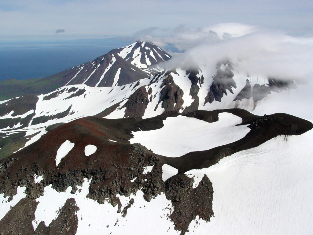
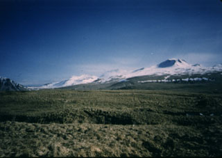 The Atka volcanic complex at the NE tip of Atka Island is one of the largest volcanic centers in the central Aleutians. It contains a caldera and is surrounded by 7 or 8 smaller cones. This view from the south near Atka village shows Korovin, the highest and northernmost of three Holocene cones of the Atka complex.
 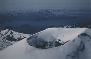 This view from the NE in June 1986 shows steam rising from the summit crater of Korovin, north of Atka. It has been reported to have a cylindrical vent of greatly variable depth depending on the presence of a lake.
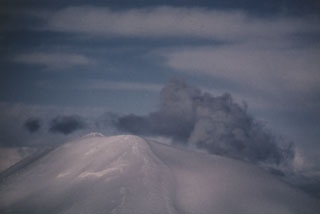 A gas-and-steam plume, possibly containing minor amounts of ash, rises above the summit of Korovin volcano on 4 March 1987. This view of Korovin, north of Atka, was taken from the south. A satellite image on 18 March showed three distinct plumes originating from Korovin and two vents to the south.
 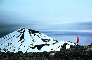 Korovin is seen here from the S, with the smaller Konia cone on its SE flank. Korovin is one of the most frequently active centers of the large complex at the NE tip of Atka Island, and contains two craters near the summit. The SE cone has a 1-km-wide crater, larger than the NW summit.
 An aerial view from the WNW shows a young vent on the NE side of Kluichef, which was constructed within the Pleistocene Atka caldera.
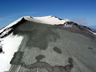 A satellite image on 4 July 2004 showed fresh ash deposits on the upper E flank of Korovin. This photo, taken from the SE, show ash emplaced on the upper slopes of the SE crater.
 This photo taken on 3 March 2007 shows a light-gray ash deposit on the W flank of Korovin. In late November 2006 satellite images showed a light dusting of ash on the E flank of the main crater along with several plumes and/or their shadows visible along the N side of the crater. On 11 and 21 December 2006 Atka residents again witnessed steam plumes, possibly containing ash on the latter date.
There are no samples for Atka Volcanic Complex in the Smithsonian's NMNH Department of Mineral Sciences Rock and Ore collection.
| Alaska Volcano Observatory (Link to Atka Volcanic Complex) | The Alaska Volcano Observatory (AVO) is a joint program of the U.S. Geological Survey (USGS), the Geophysical Institute of the University of Alaska Fairbanks (UAFGI), and the State of Alaska Division of Geological and Geophysical Surveys (ADGGS). AVO was formed in 1988, and uses federal, state, and university resources to monitor and study Alaska's hazardous volcanoes, to predict and record eruptive activity, and to mitigate volcanic hazards to life and property. |
| Copernicus Browser | The Copernicus Browser replaced the Sentinel Hub Playground browser in 2023, to provide access to Earth observation archives from the Copernicus Data Space Ecosystem, the main distribution platform for data from the EU Copernicus missions. |
| MIROVA | Middle InfraRed Observation of Volcanic Activity (MIROVA) is a near real time volcanic hot-spot detection system based on the analysis of MODIS (Moderate Resolution Imaging Spectroradiometer) data. In particular, MIROVA uses the Middle InfraRed Radiation (MIR), measured over target volcanoes, in order to detect, locate and measure the heat radiation sourced from volcanic activity. |
| MODVOLC Thermal Alerts | Using infrared satellite Moderate Resolution Imaging Spectroradiometer (MODIS) data, scientists at the Hawai'i Institute of Geophysics and Planetology, University of Hawai'i, developed an automated system called MODVOLC to map thermal hot-spots in near real time. For each MODIS image, the algorithm automatically scans each 1 km pixel within it to check for high-temperature hot-spots. When one is found the date, time, location, and intensity are recorded. MODIS looks at every square km of the Earth every 48 hours, once during the day and once during the night, and the presence of two MODIS sensors in space allows at least four hot-spot observations every two days. Each day updated global maps are compiled to display the locations of all hot spots detected in the previous 24 hours. There is a drop-down list with volcano names which allow users to 'zoom-in' and examine the distribution of hot-spots at a variety of spatial scales. |
|
WOVOdat
Single Volcano View Temporal Evolution of Unrest Side by Side Volcanoes |
WOVOdat is a database of volcanic unrest; instrumentally and visually recorded changes in seismicity, ground deformation, gas emission, and other parameters from their normal baselines. It is sponsored by the World Organization of Volcano Observatories (WOVO) and presently hosted at the Earth Observatory of Singapore.
GVMID Data on Volcano Monitoring Infrastructure The Global Volcano Monitoring Infrastructure Database GVMID, is aimed at documenting and improving capabilities of volcano monitoring from the ground and space. GVMID should provide a snapshot and baseline view of the techniques and instrumentation that are in place at various volcanoes, which can be use by volcano observatories as reference to setup new monitoring system or improving networks at a specific volcano. These data will allow identification of what monitoring gaps exist, which can be then targeted by remote sensing infrastructure and future instrument deployments. |
| Volcanic Hazard Maps | The IAVCEI Commission on Volcanic Hazards and Risk has a Volcanic Hazard Maps database designed to serve as a resource for hazard mappers (or other interested parties) to explore how common issues in hazard map development have been addressed at different volcanoes, in different countries, for different hazards, and for different intended audiences. In addition to the comprehensive, searchable Volcanic Hazard Maps Database, this website contains information about diversity of volcanic hazard maps, illustrated using examples from the database. This site is for educational purposes related to volcanic hazard maps. Hazard maps found on this website should not be used for emergency purposes. For the most recent, official hazard map for a particular volcano, please seek out the proper institutional authorities on the matter. |
| IRIS seismic stations/networks | Incorporated Research Institutions for Seismology (IRIS) Data Services map showing the location of seismic stations from all available networks (permanent or temporary) within a radius of 0.18° (about 20 km at mid-latitudes) from the given location of Atka Volcanic Complex. Users can customize a variety of filters and options in the left panel. Note that if there are no stations are known the map will default to show the entire world with a "No data matched request" error notice. |
| UNAVCO GPS/GNSS stations | Geodetic Data Services map from UNAVCO showing the location of GPS/GNSS stations from all available networks (permanent or temporary) within a radius of 20 km from the given location of Atka Volcanic Complex. Users can customize the data search based on station or network names, location, and time window. Requires Adobe Flash Player. |
| DECADE Data | The DECADE portal, still in the developmental stage, serves as an example of the proposed interoperability between The Smithsonian Institution's Global Volcanism Program, the Mapping Gas Emissions (MaGa) Database, and the EarthChem Geochemical Portal. The Deep Earth Carbon Degassing (DECADE) initiative seeks to use new and established technologies to determine accurate global fluxes of volcanic CO2 to the atmosphere, but installing CO2 monitoring networks on 20 of the world's 150 most actively degassing volcanoes. The group uses related laboratory-based studies (direct gas sampling and analysis, melt inclusions) to provide new data for direct degassing of deep earth carbon to the atmosphere. |
| Large Eruptions of Atka Volcanic Complex | Information about large Quaternary eruptions (VEI >= 4) is cataloged in the Large Magnitude Explosive Volcanic Eruptions (LaMEVE) database of the Volcano Global Risk Identification and Analysis Project (VOGRIPA). |
| EarthChem | EarthChem develops and maintains databases, software, and services that support the preservation, discovery, access and analysis of geochemical data, and facilitate their integration with the broad array of other available earth science parameters. EarthChem is operated by a joint team of disciplinary scientists, data scientists, data managers and information technology developers who are part of the NSF-funded data facility Integrated Earth Data Applications (IEDA). IEDA is a collaborative effort of EarthChem and the Marine Geoscience Data System (MGDS). |