Report on Bristol Island (United Kingdom) — 1 June-7 June 2016
Smithsonian Institution / US Geological Survey
Weekly Volcanic Activity Report, 1 June-7 June 2016
Managing Editor: Sally Sennert.
Please cite this report as:
Global Volcanism Program, 2016. Report on Bristol Island (United Kingdom) (Sennert, S, ed.). Weekly Volcanic Activity Report, 1 June-7 June 2016. Smithsonian Institution and US Geological Survey.
Bristol Island
United Kingdom
59.017°S, 26.533°W; summit elev. 1100 m
All times are local (unless otherwise noted)
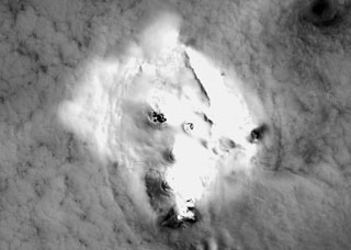
The Buenos Aires VAAC reported that weather clouds mostly prevented satellite observations of Bristol Island's Mt. Sourabaya during 1-6 June, though a thermal anomaly was detected during 1-2 and 5-6 June.
Geological Summary. The 9 x 10 km Bristol Island near the southern end of the South Sandwich arc lies across Fortser's Passage from the Southern Thule Islands and forms one of the largest islands of the chain. Largely glacier-covered, it contains a horseshoe-shaped ridge at the interior extending northward from the highest peak, 1100-m-high Mount Darnley. A steep-sided flank cone or lava dome, Havfruen Peak, is located on the east side, and a young crater and fissure are on the west flank. Three large sea stacks lying off Turmoil Point at the western tip of the island may be remnants of an older now-eroded volcanic center. Both summit and flank vents have been active during historical time. The latest eruption, during 1956, originated from the west-flank crater, and deposited cinder over the icecap. The extensive icecap and the difficulty of landing make it the least explored of the South Sandwich Islands.