Report on Shishaldin (United States) — 13 September-19 September 2023
Smithsonian Institution / US Geological Survey
Weekly Volcanic Activity Report, 13 September-19 September 2023
Managing Editor: Sally Sennert.
Please cite this report as:
Global Volcanism Program, 2023. Report on Shishaldin (United States) (Sennert, S, ed.). Weekly Volcanic Activity Report, 13 September-19 September 2023. Smithsonian Institution and US Geological Survey.
Shishaldin
United States
54.756°N, 163.97°W; summit elev. 2857 m
All times are local (unless otherwise noted)
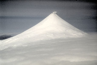
AVO reported that the eruption at Shishaldin continued during 13-19 September. Eruptive activity increased during 13-14 September. Elevated surface temperatures began to be identified in satellite images during the afternoon of 13 September and they increased later that night. Seismic tremor amplitudes began to increase at around 1800 and small explosions were detected in seismic and infrasound data. Incandescent lava at the summit was seen in a webcam image at 0134 on 14 September during a period of elevated tremor. No ash emissions were visible though high weather clouds may have obscured them.
Seismic tremor began to increase sometime around 0900 on 15 September and rapidly intensified. An explosive eruption began at around 1710, prompting AVO to the Aviation Color Code to Red (the highest color on a four-color scale) and the Volcano Alert Level to Warning (the highest level on a four-level scale). Within about 30 minutes ash plumes drifted E below a weather cloud deck at 8.2 km (27,000 ft) a.s.l., unseen in satellite views. The National Weather Service estimated that an ash-rich plume rose as high as 12.8 km (42,000 ft) a.s.l. and produced volcanic lightning. The upper parts of the plume detached by 1830, at about the same time that seismicity dramatically decreased. Lightning was again detected beginning around 1930, suggesting that ash emissions continued. Ongoing explosions were detected in infrasound data, at a lower level than during the most energetic phase of this event. Trace amounts of ash fell in False Pass (38 km ENE) during 1800-2030. Lightning was last detected at 2048. By 2124 the intensity of the eruption had decreased, and ash emissions were likely rising to altitudes less than 6.7 km (22,000 ft) a.s.l. Seismicity returned to pre-eruption levels; at 1244 on 16 September AVO lowered the Volcano Alert Level to Watch and the Aviation Color Code to Orange. A plume of sulfur dioxide emitted during 14-15 September was detected over the North Pacific. Seismicity remained elevated with tremor and small daily earthquakes occurring over 16-18 September. Elevated surface temperatures at the summit were identified in satellite data and minor steam emissions were visible in webcam views.
Geological Summary. The symmetrical glacier-covered Shishaldin in the Aleutian Islands is the westernmost of three large stratovolcanoes in the eastern half of Unimak Island. The Aleuts named the volcano Sisquk, meaning "mountain which points the way when I am lost." Constructed atop an older glacially dissected edifice, it is largely basaltic in composition. Remnants of an older edifice are exposed on the W and NE sides at 1,500-1,800 m elevation. There are over two dozen pyroclastic cones on its NW flank, which is covered by massive aa lava flows. Frequent explosive activity, primarily consisting of Strombolian ash eruptions from the small summit crater, but sometimes producing lava flows, has been recorded since the 18th century. A steam plume often rises from the summit crater.
Source: US Geological Survey Alaska Volcano Observatory (AVO)