
GeoNet reported that the Mud Rift feature at Okataina's Waimangu Geothermal area erupted during 17-20 May, the first time since 1989. The Mud Rift geothermal vent formed in 1906 in the Raupo Pond Crater (one of multiple craters which formed in June 1886) and is 36 m long, 5-6 m wide, and 15 m deep. The steam-driven events mostly ejected fine sand and mud, and there was abundant evidence of fluids flooding into the rift, especially at the W end. Nearby vegetation was brown, and there was some evidence of collapse around the edges of the vents.
Source: GeoNet
Tectonic seismic swarm; no co-seismic deformation
A short but intense sequence of earthquakes occurred in the Lake Rotomahana area of the [Tarawera] rift on 16 November. The largest event (ML 3.8) occurred at 1835, in the middle of the sequence; events continued until about 2000. A geodetic survey of the Lake Rotomahana strain monitoring pattern was completed ~20 minutes before the earthquake sequence commenced. Selected stations were reoccupied three days later but no significant co-seismic deformation was detected. All the earthquakes appeared to be of tectonic origin. Similar swarms were recorded 22-23 February 1986 and in February 1983.
The 17-km-long Tarawera Rift was the site of a vigorous eruption in 1886 that ejected ~0.7 km3 of basaltic magma in ~4 hours (Nairn and others, 1986); large phreatic explosions occurred from Lake Rotomahana, which has grown substantially since that eruption. Phreatic explosions have been recorded [16] times between 1896 and 1973 in the [Waimangu] thermal area to the SW, along the rift.
Reference. Nairn, I.A., Cole, J.W., Houghton, B.F., and Wilson, C.J.N., 1986, Tarawera 1886 eruption: International Volcanological Congress Handbook, 1-9 February 1986, p. 111-121.
Information Contacts: B. Scott, NZGS Rotorua; S. Sherburn, DSIR Geophysics, Wairakei.
2016: June
GeoNet reported that the Mud Rift feature at Okataina's Waimangu Geothermal area erupted during 17-20 May, the first time since 1989. The Mud Rift geothermal vent formed in 1906 in the Raupo Pond Crater (one of multiple craters which formed in June 1886) and is 36 m long, 5-6 m wide, and 15 m deep. The steam-driven events mostly ejected fine sand and mud, and there was abundant evidence of fluids flooding into the rift, especially at the W end. Nearby vegetation was brown, and there was some evidence of collapse around the edges of the vents.
Source: GeoNet
Reports are organized chronologically and indexed below by Month/Year (Publication Volume:Number), and include a one-line summary. Click on the index link or scroll down to read the reports.
Shallow earthquakes; no volcanic tremor
A series of shallow earthquakes occurred 23-29 September a few kilometers SE of Haroharo Dome, in the Okataina Volcanic Center (figure 1). The main earthquake was at 1423 on 23 September. A foreshock preceded it by about 3 minutes, and three of the four large aftershocks followed at 1429, 1440, and 1452 (table 1). Many other aftershocks were recorded, the last at 0530 on 29 September.
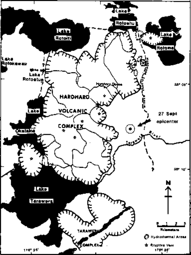 |
Figure 1. Map showing the Haroharo Volcanic Complex and part of the Tarawera Volcano in the Okataina Volcanic Center. From Cole and Nairn (1975). |
Table 1. Earthquakes of M > 2.5 recorded in the Okataina Volcanic Center during 23-29 September 1982.
| Date | Time | Magnitude |
| 23 Sep 1982 | 1420 | [3.3] |
| 23 Sep 1982 | 1423 | 4.1 |
| 23 Sep 1982 | 1429 | 2.6 |
| 23 Sep 1982 | 1440 | 3.2 |
| 23 Sep 1982 | 1452 | [2.9] |
| 27 Sep 1982 | 1806 | [2.7] |
I.A. Nairn, working on the N side of Tarawera Volcano (~11 km S of the epicenters) on 23 September, felt shocks and heard rockfalls nearby. He estimated the Modified Mercalli intensities of the foreshock and main shock as IV, and of the aftershocks at 1440 and 1452 at III-IV. He described the ground vibrations as low-frequency but relatively large-amplitude. Other nearby NZGS personnel noted the relatively low frequency of the felt shocks compared to typical local felt earthquakes. Observers noted that although they did not feel the shocks strongly outdoors, houses and vehicles resonated to large-amplitude vibrations. A small seiche was recorded on the N side of Lake Tarawera (7-8 km SW of the events). Three tilt networks around Tarawera Volcano showed no significant changes.
J.H. Latter placed the hypocenter for the 27 September event [at 38.129°S, 176.531°E, figure 1] about 5 km SE of Haroharo Dome at a depth of about 2 km. Nairn reported that this location coincides with a small area of surface faulting and geothermal activity. The 23 September earthquakes could not be located because of the lack of any nearby seismic records, but epicenters were estimated to be within 6 km of the 27 September event. Latter noted that the slow propagation of energy from the earthquakes and the low frequency of the felt shocks might suggest that they were "roof rock" events generated by activity in an underlying magma body. However, no volcanic tremor was detected during or after the earthquake sequence.
Although Haroharo has not been historically active, five eruptions in the last 10,000 years have been dated by 14C or tephrochronological methods. Very large explosive eruptions occurred roughly 2,050, 2,850, 5,050, and 7,050 years before the present (BP). Dome extrusion occurred at 2,450 years BP (± 400 years).
[Reference. Cole, J.W., and Nairn, I.A., 1975, Catalog of active volcanoes of the world, part XXII.]
Information Contacts: J. Latter, DSIR, Wellington; I. Nairn and B. Scott, NZGS, Rotorua; P. Otway, NZGS, Wairakei.
Tectonic seismic swarm; no co-seismic deformation
A short but intense sequence of earthquakes occurred in the Lake Rotomahana area of the [Tarawera] rift on 16 November. The largest event (ML 3.8) occurred at 1835, in the middle of the sequence; events continued until about 2000. A geodetic survey of the Lake Rotomahana strain monitoring pattern was completed ~20 minutes before the earthquake sequence commenced. Selected stations were reoccupied three days later but no significant co-seismic deformation was detected. All the earthquakes appeared to be of tectonic origin. Similar swarms were recorded 22-23 February 1986 and in February 1983.
The 17-km-long Tarawera Rift was the site of a vigorous eruption in 1886 that ejected ~0.7 km3 of basaltic magma in ~4 hours (Nairn and others, 1986); large phreatic explosions occurred from Lake Rotomahana, which has grown substantially since that eruption. Phreatic explosions have been recorded [16] times between 1896 and 1973 in the [Waimangu] thermal area to the SW, along the rift.
Reference. Nairn, I.A., Cole, J.W., Houghton, B.F., and Wilson, C.J.N., 1986, Tarawera 1886 eruption: International Volcanological Congress Handbook, 1-9 February 1986, p. 111-121.
Information Contacts: B. Scott, NZGS Rotorua; S. Sherburn, DSIR Geophysics, Wairakei.
This compilation of synonyms and subsidiary features may not be comprehensive. Features are organized into four major categories: Cones, Craters, Domes, and Thermal Features. Synonyms of features appear indented below the primary name. In some cases additional feature type, elevation, or location details are provided.
Cones |
||||
| Feature Name | Feature Type | Elevation | Latitude | Longitude |
|
Maungakakaramea
Rainbow Mountain |
Cone | 743 m | 38° 19' 0" S | 176° 23' 0" E |
| Maungaongaonga | Cone | 826 m | 38° 20' 0" S | 176° 21' 0" E |
| Onepu | Cone | 189 m | 38° 4' 0" S | 176° 43' 0" E |
| Rerewhakaaitu | Tuff cone | 38° 16' 0" S | 176° 30' 0" E | |
| Rotorua | Vent | |||
| Tuahu | Tuff cone | 790 m | 38° 7' 0" S | 176° 28' 0" E |
Craters |
||||
| Feature Name | Feature Type | Elevation | Latitude | Longitude |
| Awaatua Bay | Crater | 438 m | 38° 17' 0" S | 176° 30' 0" E |
| Haroharo | Fissure vent | 914 m | 38° 5' 31" S | 176° 30' 29" E |
| Rerewhakaaitu | Fissure vent | 438 m | 38° 17' 0" S | 176° 30' 0" E |
| Rotoatua, Lake | Crater | 38° 4' 0" S | 176° 25' 0" E | |
| Rotoiti | Pleistocene caldera | |||
| Rotokawau, Lake | Maar | 38° 4' 0" S | 176° 23' 0" E | |
| Rotoma | Pleistocene caldera | 38° 3' 0" S | 176° 35' 0" E | |
| Tarawera | Fissure vent | 1111 m | 38° 14' 0" S | 176° 30' 0" E |
| Te Whekau | Crater | 38° 10' 0" S | 176° 23' 0" E | |
|
Wahanga-Waimangu
Chasm, The |
Fissure vent | 1111 m | 38° 14' 0" S | 176° 30' 0" E |
Domes |
||||
| Feature Name | Feature Type | Elevation | Latitude | Longitude |
| Crater Dome | Dome | 38° 14' 0" S | 176° 30' 0" E | |
| Eastern Dome | Dome | 518 m | 38° 13' 0" S | 176° 34' 0" E |
| Edgecumbe, Mount | Dome | 821 m | 38° 6' 0" S | 176° 44' 0" E |
| Green Lake Plug | Dome | 366 m | 38° 15' 0" S | 176° 28' 0" E |
| Hainini | Dome | 38° 8' 0" S | 176° 29' 0" E | |
|
Kanakana
Plateau Dome |
Dome | 945 m | 38° 14' 0" S | 176° 31' 0" E |
| Makatiti | Dome | 914 m | 38° 9' 0" S | 176° 28' 0" E |
| Mangawhakamana | Dome | 728 m | 38° 8' 0" S | 176° 35' 0" E |
| Matahawra | Dome | 550 m | 38° 2' 0" S | 176° 29' 0" E |
| Pararoa | Dome | 525 m | 38° 4' 0" S | 176° 34' 0" E |
| Parewhaiti | Dome | 700 m | 38° 7' 0" S | 176° 30' 0" E |
| Puhipuhi | Dome | 335 m | 38° 11' 0" S | 176° 36' 0" E |
| Pukepoto | Dome | 686 m | 38° 9' 0" S | 176° 21' 0" E |
|
Ridge Dome
Waiwhakapa |
Dome | 830 m | 38° 15' 0" S | 176° 32' 0" E |
| Rotokakahi | Dome | 680 m | 38° 13' 0" S | 176° 21' 0" E |
| Rotokohu | Dome | 38° 6' 0" S | 176° 31' 0" E | |
| Rotomahana | Dome | 38° 15' 0" S | 176° 29' 0" E | |
| Ruawahia | Dome | 1111 m | 38° 14' 0" S | 176° 30' 0" E |
|
Southern Dome
Koa |
Dome | 1024 m | 38° 15' 0" S | 176° 30' 0" E |
| Tapahoro | Dome | 914 m | 38° 8' 0" S | 176° 29' 0" E |
| Te Hapeotoroa | Dome | 577 m | 38° 17' 0" S | 176° 25' 0" E |
| Te Horoa | Dome | 38° 10' 0" S | 176° 25' 0" E | |
| Te Kumete | Dome | 544 m | 38° 15' 0" S | 176° 25' 0" E |
| Tikorangi | Dome | 550 m | 38° 4' 0" S | 176° 33' 0" E |
| Tutaeheka | Dome | 719 m | 38° 15' 0" S | 176° 21' 0" E |
| Wahanga | Dome | 975 m | 38° 13' 0" S | 176° 31' 0" E |
| Western Dome | Dome | 38° 15' 0" S | 176° 28' 0" E | |
| Whakapoungakau | Dome | 759 m | 38° 6' 0" S | 176° 24' 0" E |
Thermal |
||||
| Feature Name | Feature Type | Elevation | Latitude | Longitude |
| Kawerau | Thermal | 60 m | 38° 3' 0" S | 176° 43' 0" E |
| Onepu Springs | Hot Spring | 60 m | 38° 3' 0" S | 176° 43' 0" E |
| Otei Springs | Hot Spring | 319 m | 38° 3' 0" S | 176° 34' 0" E |
| Paukohurea | Thermal | 400 m | 38° 19' 0" S | 176° 19' 0" E |
|
Rotoma Geothermal Field
Rotoehu, Lake |
Thermal | 305 m | 38° 2' 0" S | 176° 33' 0" E |
| Rotomahana | Thermal | 335 m | 38° 17' 0" S | 176° 25' 0" E |
| Te Haehaenga | Thermal | |||
| Te Kopia | Thermal | 610 m | 38° 24' 29" S | 176° 14' 0" E |
| Waikite | Thermal | 400 m | 38° 19' 0" S | 176° 19' 0" E |
| Waimangu | Thermal | 468 m | 38° 17' 0" S | 176° 23' 0" E |
| Waitangi Soda Springs | Hot Spring | 305 m | 38° 2' 0" S | 176° 33' 0" E |
|
|
||||||||||||||||||||||||||
There is data available for 31 confirmed Holocene eruptive periods.
1981 May 16 ± 15 days - 1981 May 16 ± 15 days Confirmed Eruption Max VEI: 1
| Episode 1 | Eruption Episode | Waimangu (Raupo Pond crater) | |||||||||||||||||||
|---|---|---|---|---|---|---|---|---|---|---|---|---|---|---|---|---|---|---|---|---|
| 1981 May 16 ± 15 days - 1981 May 16 ± 15 days | Evidence from Observations: Reported | |||||||||||||||||||
|
List of 2 Events for Episode 1 at Waimangu (Raupo Pond crater)
| ||||||||||||||||||||
1978 Feb 23 - 1978 Feb 23 Confirmed Eruption Max VEI: 1
| Episode 1 | Eruption Episode | Waimangu (Raupo Pond, Inferno Crater) | |||||||||||||||||||
|---|---|---|---|---|---|---|---|---|---|---|---|---|---|---|---|---|---|---|---|---|
| 1978 Feb 23 - 1978 Feb 23 | Evidence from Observations: Reported | |||||||||||||||||||
|
List of 2 Events for Episode 1 at Waimangu (Raupo Pond, Inferno Crater)
| ||||||||||||||||||||
1973 Feb 22 - 1973 Feb 22 Confirmed Eruption Max VEI: 1
| Episode 1 | Eruption Episode | Waimangu (Echo Crater) | ||||||||||||||||||||||||
|---|---|---|---|---|---|---|---|---|---|---|---|---|---|---|---|---|---|---|---|---|---|---|---|---|---|
| 1973 Feb 22 - 1973 Feb 22 | Evidence from Observations: Reported | ||||||||||||||||||||||||
|
List of 3 Events for Episode 1 at Waimangu (Echo Crater)
| |||||||||||||||||||||||||
1951 Jun 16 ± 15 days Confirmed Eruption Max VEI: 1
| Episode 1 | Eruption Episode | Rotomahana | |||||||||||||||||||
|---|---|---|---|---|---|---|---|---|---|---|---|---|---|---|---|---|---|---|---|---|
| 1951 Jun 16 ± 15 days - Unknown | Evidence from Observations: Reported | |||||||||||||||||||
|
List of 2 Events for Episode 1 at Rotomahana
| ||||||||||||||||||||
1926 Nov 17 - 1926 Nov 18 Confirmed Eruption Max VEI: 1
| Episode 1 | Eruption Episode | Rotomahana | |||||||||||||||||||
|---|---|---|---|---|---|---|---|---|---|---|---|---|---|---|---|---|---|---|---|---|
| 1926 Nov 17 - 1926 Nov 18 | Evidence from Observations: Reported | |||||||||||||||||||
|
List of 2 Events for Episode 1 at Rotomahana
| ||||||||||||||||||||
1924 Confirmed Eruption Max VEI: 1
| Episode 1 | Eruption Episode | Waimangu (Echo Crater) | |||||||||||||||||||
|---|---|---|---|---|---|---|---|---|---|---|---|---|---|---|---|---|---|---|---|---|
| 1924 - Unknown | Evidence from Observations: Reported | |||||||||||||||||||
|
List of 2 Events for Episode 1 at Waimangu (Echo Crater)
| ||||||||||||||||||||
1918 - 1920 Confirmed Eruption Max VEI: 1
| Episode 1 | Eruption Episode | Waimangu (Echo Crater) | |||||||||||||||||||
|---|---|---|---|---|---|---|---|---|---|---|---|---|---|---|---|---|---|---|---|---|
| 1918 - 1920 | Evidence from Observations: Reported | |||||||||||||||||||
|
List of 2 Events for Episode 1 at Waimangu (Echo Crater)
| ||||||||||||||||||||
1917 Mar 24 - 1917 Apr 4 Confirmed Eruption Max VEI: 1
| Episode 1 | Eruption Episode | Waimangu (Echo Crater) | |||||||||||||||||||||||||||||||||||||||
|---|---|---|---|---|---|---|---|---|---|---|---|---|---|---|---|---|---|---|---|---|---|---|---|---|---|---|---|---|---|---|---|---|---|---|---|---|---|---|---|---|
| 1917 Mar 24 - 1917 Apr 4 | Evidence from Observations: Reported | |||||||||||||||||||||||||||||||||||||||
|
List of 6 Events for Episode 1 at Waimangu (Echo Crater)
| ||||||||||||||||||||||||||||||||||||||||
1915 Nov 5 - 1915 Nov 9 Confirmed Eruption Max VEI: 1
| Episode 1 | Eruption Episode | Waimangu (Echo Crater) | |||||||||||||||||||
|---|---|---|---|---|---|---|---|---|---|---|---|---|---|---|---|---|---|---|---|---|
| 1915 Nov 5 - 1915 Nov 9 | Evidence from Observations: Reported | |||||||||||||||||||
|
List of 2 Events for Episode 1 at Waimangu (Echo Crater)
| ||||||||||||||||||||
1915 Feb 4 - 1915 Apr 13 Confirmed Eruption Max VEI: 1
| Episode 1 | Eruption Episode | Waimangu (Echo Crater & NW of Fairy Crater) | |||||||||||||||||||
|---|---|---|---|---|---|---|---|---|---|---|---|---|---|---|---|---|---|---|---|---|
| 1915 Feb 4 - 1915 Apr 13 | Evidence from Observations: Reported | |||||||||||||||||||
|
List of 2 Events for Episode 1 at Waimangu (Echo Crater & NW of Fairy Crater)
| ||||||||||||||||||||
1914 Jan 28 - 1914 Feb Confirmed Eruption Max VEI: 1
| Episode 1 | Eruption Episode | Waimangu (NW of Fairy Crater) | |||||||||||||||||||
|---|---|---|---|---|---|---|---|---|---|---|---|---|---|---|---|---|---|---|---|---|
| 1914 Jan 28 - 1914 Feb | Evidence from Observations: Reported | |||||||||||||||||||
|
List of 2 Events for Episode 1 at Waimangu (NW of Fairy Crater)
| ||||||||||||||||||||
1913 Jan 27 - 1913 Jan 27 Confirmed Eruption Max VEI: 1
| Episode 1 | Eruption Episode | Waimangu (Echo Crater) | |||||||||||||||||||
|---|---|---|---|---|---|---|---|---|---|---|---|---|---|---|---|---|---|---|---|---|
| 1913 Jan 27 - 1913 Jan 27 | Evidence from Observations: Reported | |||||||||||||||||||
|
List of 2 Events for Episode 1 at Waimangu (Echo Crater)
| ||||||||||||||||||||
1912 Apr Confirmed Eruption Max VEI: 1
| Episode 1 | Eruption Episode | Waimangu (Echo Crater) | |||||||||||||||||||
|---|---|---|---|---|---|---|---|---|---|---|---|---|---|---|---|---|---|---|---|---|
| 1912 Apr - Unknown | Evidence from Observations: Reported | |||||||||||||||||||
|
List of 2 Events for Episode 1 at Waimangu (Echo Crater)
| ||||||||||||||||||||
1910 Jul 24 - 1910 Jul 25 Confirmed Eruption Max VEI: 1
| Episode 1 | Eruption Episode | Waimangu (Echo Crater) | |||||||||||||||||||
|---|---|---|---|---|---|---|---|---|---|---|---|---|---|---|---|---|---|---|---|---|
| 1910 Jul 24 - 1910 Jul 25 | Evidence from Observations: Reported | |||||||||||||||||||
|
List of 2 Events for Episode 1 at Waimangu (Echo Crater)
| ||||||||||||||||||||
1908 Oct 1 - 1908 Oct 1 Confirmed Eruption Max VEI: 1
| Episode 1 | Eruption Episode | Waimangu (Echo Crater) | |||||||||||||||||||
|---|---|---|---|---|---|---|---|---|---|---|---|---|---|---|---|---|---|---|---|---|
| 1908 Oct 1 - 1908 Oct 1 | Evidence from Observations: Reported | |||||||||||||||||||
|
List of 2 Events for Episode 1 at Waimangu (Echo Crater)
| ||||||||||||||||||||
1906 Feb 21 - 1906 Feb 21 Confirmed Eruption Max VEI: 1
| Episode 1 | Eruption Episode | Waimangu (NW of Fairy Crater) | |||||||||||||||||||
|---|---|---|---|---|---|---|---|---|---|---|---|---|---|---|---|---|---|---|---|---|
| 1906 Feb 21 - 1906 Feb 21 | Evidence from Observations: Reported | |||||||||||||||||||
|
List of 2 Events for Episode 1 at Waimangu (NW of Fairy Crater)
| ||||||||||||||||||||
1905 Jun 17 - 1905 Jun 17 Confirmed Eruption Max VEI: 1
| Episode 1 | Eruption Episode | Waimangu (Echo Crater) | |||||||||||||||||||
|---|---|---|---|---|---|---|---|---|---|---|---|---|---|---|---|---|---|---|---|---|
| 1905 Jun 17 - 1905 Jun 17 | Evidence from Observations: Reported | |||||||||||||||||||
|
List of 2 Events for Episode 1 at Waimangu (Echo Crater)
| ||||||||||||||||||||
1905 Feb 18 - 1905 Feb 23 Confirmed Eruption Max VEI: 1
| Episode 1 | Eruption Episode | Waimangu (Echo Crater) | |||||||||||||||||||
|---|---|---|---|---|---|---|---|---|---|---|---|---|---|---|---|---|---|---|---|---|
| 1905 Feb 18 - 1905 Feb 23 | Evidence from Observations: Reported | |||||||||||||||||||
|
List of 2 Events for Episode 1 at Waimangu (Echo Crater)
| ||||||||||||||||||||
1900 Jan - 1904 Nov 1 Confirmed Eruption Max VEI: 1
| Episode 1 | Eruption Episode | Waimangu Geyser | ||||||||||||||||||||||||
|---|---|---|---|---|---|---|---|---|---|---|---|---|---|---|---|---|---|---|---|---|---|---|---|---|---|
| 1900 Jan - 1904 Nov 1 | Evidence from Observations: Reported | ||||||||||||||||||||||||
|
List of 3 Events for Episode 1 at Waimangu Geyser
| |||||||||||||||||||||||||
1896 Confirmed Eruption Max VEI: 1 (?)
| Episode 1 | Eruption Episode | Waimangu (Echo Crater) | |||||||||||||||||||
|---|---|---|---|---|---|---|---|---|---|---|---|---|---|---|---|---|---|---|---|---|
| 1896 - Unknown | Evidence from Observations: Reported | |||||||||||||||||||
|
List of 2 Events for Episode 1 at Waimangu (Echo Crater)
| ||||||||||||||||||||
1886 Jun 10 - 1886 Aug Confirmed Eruption Max VEI: 5
| Episode 1 | Eruption Episode | Tarawera (Wahanga-Waimangu fissure) | ||||||||||||||||||||||||||||||||||||||||||||||||||||||||||||||||||||||||||||||||||||||||||||||
|---|---|---|---|---|---|---|---|---|---|---|---|---|---|---|---|---|---|---|---|---|---|---|---|---|---|---|---|---|---|---|---|---|---|---|---|---|---|---|---|---|---|---|---|---|---|---|---|---|---|---|---|---|---|---|---|---|---|---|---|---|---|---|---|---|---|---|---|---|---|---|---|---|---|---|---|---|---|---|---|---|---|---|---|---|---|---|---|---|---|---|---|---|---|---|---|
| 1886 Jun 10 - 1886 Aug | Evidence from Observations: Reported | ||||||||||||||||||||||||||||||||||||||||||||||||||||||||||||||||||||||||||||||||||||||||||||||
|
List of 17 Events for Episode 1 at Tarawera (Wahanga-Waimangu fissure)
| |||||||||||||||||||||||||||||||||||||||||||||||||||||||||||||||||||||||||||||||||||||||||||||||
1310 ± 12 years - 1315 (?) Confirmed Eruption Max VEI: 5
| Episode 1 | Eruption Episode | Tarawera (Kaharoa eruption) | |||||||||||||||||||||||||||||||||||||||||||||||||
|---|---|---|---|---|---|---|---|---|---|---|---|---|---|---|---|---|---|---|---|---|---|---|---|---|---|---|---|---|---|---|---|---|---|---|---|---|---|---|---|---|---|---|---|---|---|---|---|---|---|---|
| 1310 ± 12 years - 1315 (?) | Evidence from Isotopic: 14C (calibrated) | |||||||||||||||||||||||||||||||||||||||||||||||||
|
List of 8 Events for Episode 1 at Tarawera (Kaharoa eruption)
| ||||||||||||||||||||||||||||||||||||||||||||||||||
0180 (?) Confirmed Eruption
| Episode 1 | Eruption Episode | Te Kopia thermal area | ||||||||||||||
|---|---|---|---|---|---|---|---|---|---|---|---|---|---|---|---|
| 0180 (?) - Unknown | Evidence from Correlation: Tephrochronology | ||||||||||||||
|
List of 1 Events for Episode 1 at Te Kopia thermal area
| |||||||||||||||
0300 BCE (?) Confirmed Eruption Max VEI: 0
| Episode 1 | Eruption Episode | Mt. Edgecumbe | ||||||||||||||||||||||||
|---|---|---|---|---|---|---|---|---|---|---|---|---|---|---|---|---|---|---|---|---|---|---|---|---|---|
| 0300 BCE (?) - Unknown | Evidence from Correlation: Tephrochronology | ||||||||||||||||||||||||
|
List of 3 Events for Episode 1 at Mt. Edgecumbe
| |||||||||||||||||||||||||
1330 BCE ± 75 years Confirmed Eruption
| Episode 1 | Eruption Episode | Mt. Edgecumbe | |||||||||||||||||||||||||||||
|---|---|---|---|---|---|---|---|---|---|---|---|---|---|---|---|---|---|---|---|---|---|---|---|---|---|---|---|---|---|---|
| 1330 BCE ± 75 years - Unknown | Evidence from Isotopic: 14C (calibrated) | |||||||||||||||||||||||||||||
|
List of 4 Events for Episode 1 at Mt. Edgecumbe
| ||||||||||||||||||||||||||||||
1750 BCE (?) Confirmed Eruption Max VEI: 4
| Episode 1 | Eruption Episode | Haroharo (Rotokawau to Rotoatua) | ||||||||||||||||||||||||
|---|---|---|---|---|---|---|---|---|---|---|---|---|---|---|---|---|---|---|---|---|---|---|---|---|---|
| 1750 BCE (?) - Unknown | Evidence from Isotopic: 14C (calibrated) | ||||||||||||||||||||||||
|
List of 3 Events for Episode 1 at Haroharo (Rotokawau to Rotoatua)
| |||||||||||||||||||||||||
3580 BCE ± 50 years Confirmed Eruption Max VEI: 5
| Episode 1 | Eruption Episode | Haroharo (Makatiti and other domes) | |||||||||||||||||||||||||||||||||||||||
|---|---|---|---|---|---|---|---|---|---|---|---|---|---|---|---|---|---|---|---|---|---|---|---|---|---|---|---|---|---|---|---|---|---|---|---|---|---|---|---|---|
| 3580 BCE ± 50 years - Unknown | Evidence from Isotopic: 14C (calibrated) | |||||||||||||||||||||||||||||||||||||||
|
List of 6 Events for Episode 1 at Haroharo (Makatiti and other domes)
| ||||||||||||||||||||||||||||||||||||||||
5550 BCE (?) Confirmed Eruption Max VEI: 0
| Episode 1 | Eruption Episode | Mt. Edgecumbe | ||||||||||||||||||||||||
|---|---|---|---|---|---|---|---|---|---|---|---|---|---|---|---|---|---|---|---|---|---|---|---|---|---|
| 5550 BCE (?) - Unknown | Evidence from Correlation: Tephrochronology | ||||||||||||||||||||||||
|
List of 3 Events for Episode 1 at Mt. Edgecumbe
| |||||||||||||||||||||||||
6060 BCE ± 50 years Confirmed Eruption Max VEI: 5
| Episode 1 | Eruption Episode | Haroharo (Te Horoa & other domes) | |||||||||||||||||||||||||||||||||||||||
|---|---|---|---|---|---|---|---|---|---|---|---|---|---|---|---|---|---|---|---|---|---|---|---|---|---|---|---|---|---|---|---|---|---|---|---|---|---|---|---|---|
| 6060 BCE ± 50 years - Unknown | Evidence from Isotopic: 14C (calibrated) | |||||||||||||||||||||||||||||||||||||||
|
List of 6 Events for Episode 1 at Haroharo (Te Horoa & other domes)
| ||||||||||||||||||||||||||||||||||||||||
7560 BCE ± 18 years Confirmed Eruption Max VEI: 5
| Episode 1 | Eruption Episode | Rotoma caldera, Tuahu, Kawerau | ||||||||||||||||||||||||||||||||||||||||||||
|---|---|---|---|---|---|---|---|---|---|---|---|---|---|---|---|---|---|---|---|---|---|---|---|---|---|---|---|---|---|---|---|---|---|---|---|---|---|---|---|---|---|---|---|---|---|
| 7560 BCE ± 18 years - Unknown | Evidence from Isotopic: 14C (calibrated) | ||||||||||||||||||||||||||||||||||||||||||||
|
List of 7 Events for Episode 1 at Rotoma caldera, Tuahu, Kawerau
| |||||||||||||||||||||||||||||||||||||||||||||
8050 BCE (?) Confirmed Eruption
| Episode 1 | Eruption Episode | West Rerewhakaaitu fissures | ||||||||||||||
|---|---|---|---|---|---|---|---|---|---|---|---|---|---|---|---|
| 8050 BCE (?) - Unknown | Evidence from Correlation: Tephrochronology | ||||||||||||||
|
List of 1 Events for Episode 1 at West Rerewhakaaitu fissures
| |||||||||||||||
There is data available for 1 deformation periods. Expand each entry for additional details.
| Start Date: 2007 | Stop Date: 2009 | Direction: Subsidence | Method: InSAR |
| Magnitude: Unknown | Spatial Extent: Unknown | Latitude: Unknown | Longitude: Unknown |
Remarks: Long-term subsidence is associated with the Kawerau geothermal field. | |||
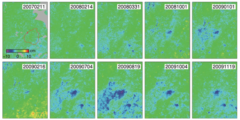 |
Time series of line-of-sight displacement at Kawerau geothermal field from ALOS PALSAR ascending path 324 starting from 20061227 (date in YYYYMMDD format). Coordinates of top-left hand side (TL) and bottom-right hand side (BR) corners are (?37.95N, 176.60E) and (?38.15N, 176.80E). Red star shows region of fastest subsidence. From: Samsonov et al. 2011. |
||
Reference List: Samsonov et al. 2011.
Full References:
Samsonov S, Beavan J, Gonzalez P J, Tiampo K, Fernandez J, 2011. Ground deformation in the Taupo Volcanic Zone, New Zealand, observed by ALOS PALSAR interferometry. Geophysical Journal International, 187(1), 147-160.
There is no Emissions History data available for Okataina.
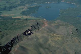 Eruptive fissures can follow the direction of regional faults, such as this New Zealand fissure that cuts diagonally across the photo. The 8-km-long fissure continues beneath the lake and was the source of a major explosive eruption in 1886 from Tarawera volcano. Most commonly, fissure vents extend radially down the flanks of a volcano from its summit. In some cases, circumferential fissures open around the rim of a volcanic caldera.
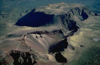 The 1886 eruptive fissure that cuts across the Tarawera lava dome complex was the source of a major explosive eruption that produced 2 cu km of basaltic tephra. The 1886 fissure cuts a group of lava domes, including the Wahanga dome at the top of the photo, which was emplaced at the end of the Kaharoa eruption about 800 years ago. That eruption produced 5 cu km of rhyolitic tephra and and another 2.5 cu km of rhyolitoc lava that formed the Wahanga, Tarawera, Crater Dome, and Ruawahia domes.
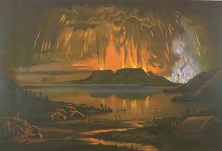 This painting shows the 10 June 1886, eruption of Tarawera, as seen across Lake Tarawera from the NW. A brief, but powerful explosive eruption lasting 5 hours originated from a NE-trending fissure that cut across the Tarawera lava dome complex. The eruption ejected 2 cu km of basaltic tephra and produced pyroclastic surges that traveled at least 6 km from the vent. Several villages were buried, and 153 people were killed.
 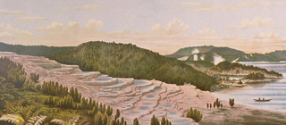 The renowned hot spring terraces at Rotomahana, one of the scenic wonders of New Zealand until the 19th century, were destroyed and buried by the 1886 eruption of Tarawera. Otukapuarangi (the Pink Terrace), shown here, and the nearby Te Tarata (the White Terrace), had been among the world's most spectacular hot spring terraces, attracting visitors from around the world.
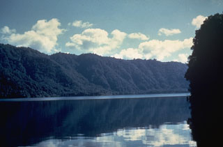 The Haroharo volcanic complex is the NW-most of two lava dome complexes forming the Okataina Volcanic Centre. A 16 x 28 km wide caldera was formed incrementally during eruptions between 300,000 and 50,000 years ago. Its rim, seen in this photo across the caldera lake, is generally obscured by a group of overlying lava domes. All post-caldera domes are less than 20,000 years old, and the most recent Haroharo eruption took place about 3,500 years ago.
 The 1886 Tarawera eruptive fissure, seen from the N, formed across lava domes of the 800-year-old Kaharoa eruption. The red and black rocks of the 1886 eruption, 20-30 m thick here, overlie white rhyolitic Kaharoa eruption deposits. This view shows a 2-km-long section of the 8-km en-echelon fissure with gray rocks of the Ruawahia lava dome appearing at the far end.
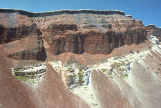 The SE part of the fissure within Ruawahia crater reveals stratigraphy from the circa 700 BP Kaharoa and 1886 CE eruptions. The 35-m-thick light-colored Kaharoa Plinian deposits at the base are largely obscured by talus fans of scoria from above. The thick overlying bright red scoria is from phase 2 of the 1886 eruption. Above it is a thin black zone (phase 3) consisting of very widespread scoria. Phase 4 (at the top) consists of white rhyolitic blocks ripped off the walls during the vent widening in the last half hour of the 10 June 1886 eruption.
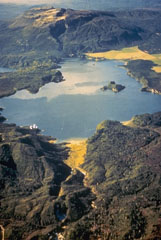 The flat-topped Tarawera lava dome complex at the top of the photo to the NE is one of two large dome complexes forming the Okataina Volcanic Centre at the N end of the Taupo Volcanic Zone. An eruptive fissure that cuts the dome complex and extends across Lake Rotomahana to the foreground was the source of a major eruption in 1886. The Tarawera complex and the Haroharo complex off the photo to the left were both sources of major explosive eruptions during the Pleistocene and Holocene that produced large ignimbrite sheets.
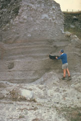 The Kaharoa eruption about 700 years ago was the first Holocene eruption of the Tarawera lava dome complex in the Okataina Volcanic Centre. It produced an extensive rhyolitic tephra deposit that extended to the E coast of North Island. Geologist Pat Brown examines a charcoalized log within a pyroclastic flow deposit from this eruption. The upper part of the section consists of blocky debris from collapse of a rhyolitic lava dome at the end of the eruption.
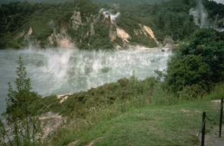 The steaming Waimangu hot pool is located near the southern end of the 1886 Tarawera eruptive fissure. Intermittent phreatic eruptions took place from this and other craters south of Lake Rotomahana from 1886 until as recently as 1973. Waimangu (black water) geyser was active from 1900 until activity ceased on 1 November 1904.
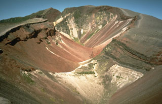 This large fissure produced during a major explosive eruption at Tarawera in 1886 is one of the youngest eruption features of the Okataina Volcanic Centre. Okataina is surrounded by extensive ignimbrite and pyroclastic deposits produced during caldera-forming eruptions. The subparallel NE-SW-trending Haroharo and Tarawera complexes consist of rhyolitic lava domes and associated lava flows that formed between about 15,000 and 800 years ago and impounded lakes against the margins of the Okataina ring structure.
The maps shown below have been scanned from the GVP map archives and include the volcano on this page. Clicking on the small images will load the full 300 dpi map. Very small-scale maps (such as world maps) are not included. The maps database originated over 30 years ago, but was only recently updated and connected to our main database. We welcome users to tell us if they see incorrect information or other problems with the maps; please use the Contact GVP link at the bottom of the page to send us email.
The following 20 samples associated with this volcano can be found in the Smithsonian's NMNH Department of Mineral Sciences collections, and may be availble for research (contact the Rock and Ore Collections Manager). Catalog number links will open a window with more information.
| Catalog Number | Sample Description | Lava Source | Collection Date |
|---|---|---|---|
| NMNH 116210-13 | Basaltic Scoria | TARAWERA | -- |
| NMNH 116210-14 | Tephra | TARAWERA | -- |
| NMNH 116210-15 | Tephra | TARAWERA, ROTOMAHANA CRATER | -- |
| NMNH 116210-16 | Tephra | TARAWERA | -- |
| NMNH 116210-18 | Basalt Scoria | HAROHARO | -- |
| NMNH 116210-19 | Volcanic Ash | HAROHARO | -- |
| NMNH 116210-20 | Ignimbrite | HAROHARO | -- |
| NMNH 116210-21 | Welded Ignimbrite | HAROHARO | -- |
| NMNH 116210-22 | Rhyolite | HAROHARO | -- |
| NMNH 117454-25 | Perlite | Tarawera South Dome; Waimrangu Volcanic Valley | -- |
| NMNH 117454-26 | Rhyolite | South Dome; Tarawera | -- |
| NMNH 117454-27 | Rhyolite | South Dome; Tarawera | -- |
| NMNH 117454-28 | Rhyolite | South Dome; Tarawera | -- |
| NMNH 117454-64 | Basalt | Tarawera | -- |
| NMNH 117636-1 | Perlite | -- | -- |
| NMNH 117636-2 | Obsidian | Tarawera | -- |
| NMNH 117636-3 | Pumice | Tarawera | -- |
| NMNH 117636-4 | Obsidian | Tarawera | -- |
| NMNH 117636-5 | Obsidian | Tarawera | -- |
| NMNH 117636-6 | Obsidian | Tarawera | -- |
| Copernicus Browser | The Copernicus Browser replaced the Sentinel Hub Playground browser in 2023, to provide access to Earth observation archives from the Copernicus Data Space Ecosystem, the main distribution platform for data from the EU Copernicus missions. |
| MIROVA | Middle InfraRed Observation of Volcanic Activity (MIROVA) is a near real time volcanic hot-spot detection system based on the analysis of MODIS (Moderate Resolution Imaging Spectroradiometer) data. In particular, MIROVA uses the Middle InfraRed Radiation (MIR), measured over target volcanoes, in order to detect, locate and measure the heat radiation sourced from volcanic activity. |
| MODVOLC Thermal Alerts | Using infrared satellite Moderate Resolution Imaging Spectroradiometer (MODIS) data, scientists at the Hawai'i Institute of Geophysics and Planetology, University of Hawai'i, developed an automated system called MODVOLC to map thermal hot-spots in near real time. For each MODIS image, the algorithm automatically scans each 1 km pixel within it to check for high-temperature hot-spots. When one is found the date, time, location, and intensity are recorded. MODIS looks at every square km of the Earth every 48 hours, once during the day and once during the night, and the presence of two MODIS sensors in space allows at least four hot-spot observations every two days. Each day updated global maps are compiled to display the locations of all hot spots detected in the previous 24 hours. There is a drop-down list with volcano names which allow users to 'zoom-in' and examine the distribution of hot-spots at a variety of spatial scales. |
|
WOVOdat
Single Volcano View Temporal Evolution of Unrest Side by Side Volcanoes |
WOVOdat is a database of volcanic unrest; instrumentally and visually recorded changes in seismicity, ground deformation, gas emission, and other parameters from their normal baselines. It is sponsored by the World Organization of Volcano Observatories (WOVO) and presently hosted at the Earth Observatory of Singapore.
GVMID Data on Volcano Monitoring Infrastructure The Global Volcano Monitoring Infrastructure Database GVMID, is aimed at documenting and improving capabilities of volcano monitoring from the ground and space. GVMID should provide a snapshot and baseline view of the techniques and instrumentation that are in place at various volcanoes, which can be use by volcano observatories as reference to setup new monitoring system or improving networks at a specific volcano. These data will allow identification of what monitoring gaps exist, which can be then targeted by remote sensing infrastructure and future instrument deployments. |
| Volcanic Hazard Maps | The IAVCEI Commission on Volcanic Hazards and Risk has a Volcanic Hazard Maps database designed to serve as a resource for hazard mappers (or other interested parties) to explore how common issues in hazard map development have been addressed at different volcanoes, in different countries, for different hazards, and for different intended audiences. In addition to the comprehensive, searchable Volcanic Hazard Maps Database, this website contains information about diversity of volcanic hazard maps, illustrated using examples from the database. This site is for educational purposes related to volcanic hazard maps. Hazard maps found on this website should not be used for emergency purposes. For the most recent, official hazard map for a particular volcano, please seek out the proper institutional authorities on the matter. |
| IRIS seismic stations/networks | Incorporated Research Institutions for Seismology (IRIS) Data Services map showing the location of seismic stations from all available networks (permanent or temporary) within a radius of 0.18° (about 20 km at mid-latitudes) from the given location of Okataina. Users can customize a variety of filters and options in the left panel. Note that if there are no stations are known the map will default to show the entire world with a "No data matched request" error notice. |
| UNAVCO GPS/GNSS stations | Geodetic Data Services map from UNAVCO showing the location of GPS/GNSS stations from all available networks (permanent or temporary) within a radius of 20 km from the given location of Okataina. Users can customize the data search based on station or network names, location, and time window. Requires Adobe Flash Player. |
| DECADE Data | The DECADE portal, still in the developmental stage, serves as an example of the proposed interoperability between The Smithsonian Institution's Global Volcanism Program, the Mapping Gas Emissions (MaGa) Database, and the EarthChem Geochemical Portal. The Deep Earth Carbon Degassing (DECADE) initiative seeks to use new and established technologies to determine accurate global fluxes of volcanic CO2 to the atmosphere, but installing CO2 monitoring networks on 20 of the world's 150 most actively degassing volcanoes. The group uses related laboratory-based studies (direct gas sampling and analysis, melt inclusions) to provide new data for direct degassing of deep earth carbon to the atmosphere. |
| Large Eruptions of Okataina | Information about large Quaternary eruptions (VEI >= 4) is cataloged in the Large Magnitude Explosive Volcanic Eruptions (LaMEVE) database of the Volcano Global Risk Identification and Analysis Project (VOGRIPA). |
| EarthChem | EarthChem develops and maintains databases, software, and services that support the preservation, discovery, access and analysis of geochemical data, and facilitate their integration with the broad array of other available earth science parameters. EarthChem is operated by a joint team of disciplinary scientists, data scientists, data managers and information technology developers who are part of the NSF-funded data facility Integrated Earth Data Applications (IEDA). IEDA is a collaborative effort of EarthChem and the Marine Geoscience Data System (MGDS). |

