CVGHM reported that seismicity at Seulawah Agam increased during 27 December-2 January. Visual observations were prevented due to fog, although on 2 January scientists observed a new solfatara that produced roaring noises and was within 20 m of van Heutsz Crater on the NNE flank. The Alert Level was raised to 2 (on a scale of 1-4) on 3 January.
Source: Pusat Vulkanologi dan Mitigasi Bencana Geologi (PVMBG, also known as CVGHM)
Alert Level raised due to increased seismicity in January 2013
Seulawah Agam (also known as Seuleuwah Agam) volcano, one of three active stratovolcanoes in the Aceh province (>5 million inhabitants), is located at the NW tip of Sumatra. Seulawah Agam has two craters, van Heutsz (Heszt), the most active crater at an elevation of 714 m on the N flank, and Simpago on the S flank. The Indonesian Center of Volcanology and Geological Hazard Mitigation (CVGHM) reported that activity at Seulawah Agam is generally characterized by white plumes rising ˜1 m from the crater. Seulawah Agam has remained non-eruptive through at least 2 January 2013.
Historical data indicated that Seulawah Agam volcano last erupted 12-13 January 1839 on its NNE flank (van Heutsz crater). Prior to that, an eruption occurred in 1510 (˜10 years), also on its NNE flank.
During April to August 2010, the seismic data suggested increased activity overall, with marginal fluctuation. On 1 September 2010, CVGHM raised the Alert Level from I to II and restricted visitors from approaching the crater within a 3-km radius. [The 4-level Indonesian Alert Level Scale is as follows: I - Normal (green); II - Waspada or Alert (yellow); III - Siaga or Standby (orange); and IV - Awas or Aware (red).]
During October 2010-July 2011 overall activity at Seulawah Agam decreased; seismicity, water temperature, and magmatic gas emissions decreased, but pH measurements were stable and no significant changes at the surface were observed. The volcano was often shrouded in fog during this period. On 11 July 2011 the Alert Level was lowered from II to I.
Beginning on 27 December 2012 (table 3), there was an increase in deep volcanic seismicity over the course of the following week. Visual observations were often prevented due to fog, although on 2 January 2013 scientists observed a new solfatara (a natural volcanic steam vent in which sulfur gases are the dominant constituent, along with hot water vapor) that produced roaring noises and emissions which drifted ˜20 m out from van Heutsz Crater. On 3 January 2013 the Alert Level was raised from I to II; then, on 11 May 2013, the Level was lowered to I.
Table 3. Daily numbers of earthquakes measured at Seulawah Agam volcano from the week 27 Dec 2012-2 January 2013. Courtesy of CVGHM.
| Date | Deep volcanic (VA) | Shallow volcanic (VB) | Local tectonic (TL) | Long-distance tectonic (TJ) |
| 27 Dec 2012 | 4 | 1 | 3 | -- |
| 28 Dec 2012 | 8 | -- | -- | 3 |
| 29 Dec 2012 | 5 | -- | 2 | 1 |
| 30 Dec 2012 | 2 | -- | -- | 1 |
| 31 Dec 2012 | 14 | -- | 3 | 3 |
| 01 Jan 2013 | 14 | -- | 6 | 3 |
| 02 Jan 2013 | 8 | -- | 5 | 4 |
Information Contacts: Center of Volcanology and Geological Hazard Mitigation (CVGHM), Jalan Diponegoro No. 57, Bandung 40122, Indonesia (URL: http://proxy.vsi.esdm.go.id/index.php).
2013: January
2011: July
2010: September
CVGHM reported that seismicity at Seulawah Agam increased during 27 December-2 January. Visual observations were prevented due to fog, although on 2 January scientists observed a new solfatara that produced roaring noises and was within 20 m of van Heutsz Crater on the NNE flank. The Alert Level was raised to 2 (on a scale of 1-4) on 3 January.
Source: Pusat Vulkanologi dan Mitigasi Bencana Geologi (PVMBG, also known as CVGHM)
CVGHM reported that during October 2010-July 2011 activity at Seulawah Agam decreased. Measurements indicated that seismicity decreased, water temperature decreased and pH levels were stable, gas emissions were lower, and no significant surface changes were observed. The Alert Level was lowered to 1 (on a scale of 1-4) on 11 July.
Source: Pusat Vulkanologi dan Mitigasi Bencana Geologi (PVMBG, also known as CVGHM)
CVGHM reported that although seismicity from Seulawah Agam fluctuated during April to August 2010, the data reflected increased activity overall. On 1 September, CVGHM raised the Alert Level to 2 (on a scale of 1-4) and restricted visitors from approaching the crater within a 3-km radius.
Source: Pusat Vulkanologi dan Mitigasi Bencana Geologi (PVMBG, also known as CVGHM)
Reports are organized chronologically and indexed below by Month/Year (Publication Volume:Number), and include a one-line summary. Click on the index link or scroll down to read the reports.
Minor tremor during April-August 2010
This is our first report on Seulawah Agam, which has not erupted since a phreatic eruption in 1839. Beginning in April 2010, the seismicity increased at the volcano (table 1). However, visible signs of unrest were absent, although the volcano often is covered by fog.
Table 1. Types and numbers of volcanic earthquakes recorded at Seulawah Agam during April-August 2010. Background levels prior to increased April activity were not available. Courtesy of CVGHM.
| Month | Deep volcanic | Shallow volcanic |
| Apr 2010 | 66 | 70 |
| May 2010 | 55 | 121 |
| Jun 2010 | 53 | 83 |
| Jul 2010 | 46 | 76 |
| Aug 2010 | 80 | 99 |
On 1 September, based on the increase in seismicity, the Center of Volcanology and Geological Hazard Mitigation (CVGHM) raised the Alert Level to 2 (on a scale of 1-4) and restricted visitors from approaching the crater within a 3-km radius.
Information Contacts: Center of Volcanology and Geological Hazard Mitigation (CVGHM), Jalan Diponegoro 57, Bandung 40122, Indonesia (URL: http://vsi.esdm.go.id/).
172-year repose continues despite seismic crisis of September 2010-July 2011
Seismicity at Seulawah Agam volcano, Indonesia, caused the Center for Volcanology and Geological Hazard Mitigation (CVGHM) to raise the Alert Level from 1 to 2 (on a scale from 1-4) from 1 September 2010 through 11 July 2011. According to historical records, Seulawah Agam last erupted in 1839, although the likelihood and character of that eruption is in debate.
The summit of Seulawah Agam hosts a forested crater ~400 m wide (figure 1). The volcano also hosts several active fumarole fields, such as those in the van Heutsz crater, which sits on the NNE flank at ~650 m elevation (figure 2).
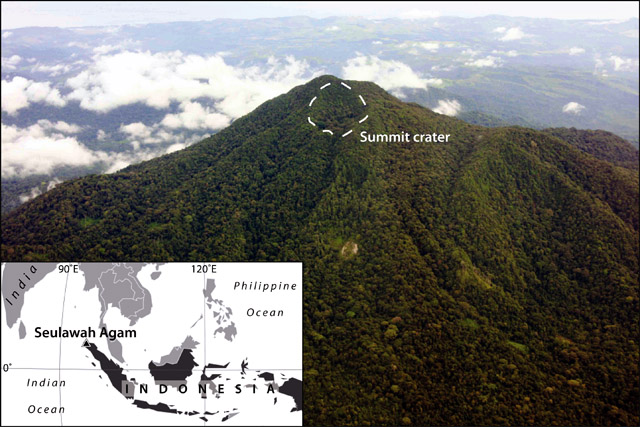 |
Figure 1. (Index map) The location of Seulawah Agam at the NW end of Sumatra island. (photo) Annotated aerial photograph of Seulawah Agam taken on 19 November 2007 looking SE, showing the ~400-m-wide, vegetated summit crater (white dashed outline). Photograph courtesy of Michael Thirnbeck; index map modified from MapsOf.net. |
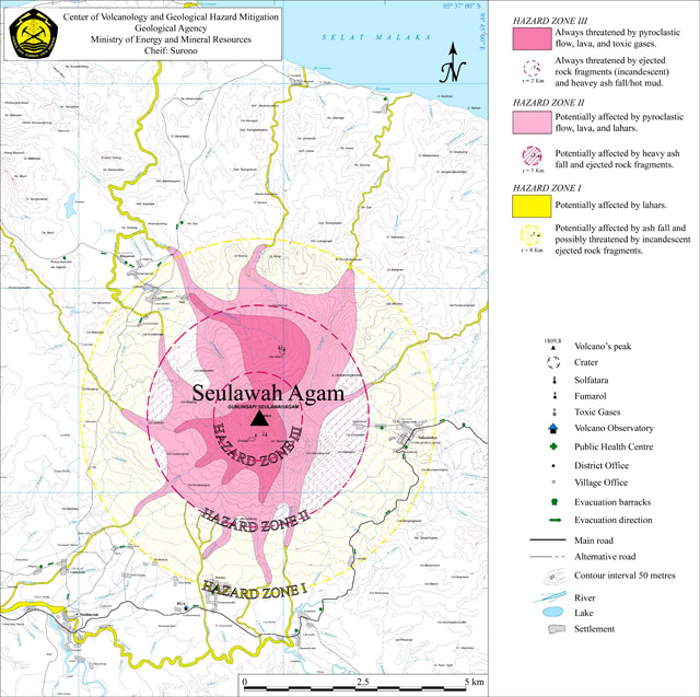 |
Figure 2. Hazard map of Seulawah Agam. Hazard Zones I-III (from outer to innermost) consist of both circular areas (indicating hazards from material dispersed through the air) and irregularly shaped areas (funneled by topography along the ground). Courtesy of the Center for Volcanology and Geological Hazard Mitigation (CVGHM). |
The hazard zones, as with all other monitored Indonesian volcanoes, concern airborne ejected/explosive material (circular zones delineating areas prone to ash fall and/or pyroclastic bombs) and ground-traveling, topographically controlled processes (irregular shaped zones delineating areas prone to lava flows, pyroclastic flows, and/or lahars); each Hazard Zone level (I-III) thus delineates a circular and an irregular area. At Seulawah Agam, the hazard zones are centered at the summit of the volcano. The van Heutsz crater, however, is located outside of the 2 km radius of Hazard Zone III, but within the topographically prone area of Hazard Zone III.
Seismicity increase. Beginning in April through September 2010 seismicity fluctuated at Seulawah Agam, although increased overall, indicating increased activity of the volcano. The Jakarta Post reported that CVGHM recorded 80 volcanic earthquakes during August 2010, the equivalent of nearly 3 volcanic earthquakes per day. On 1 September, CVGHM raised the Alert Level to 2, and restricted access to areas within 3 km of the summit crater (figure 2).
According to CVGHM, seismicity fluctuated at elevated levels from October 2010 through June 2011. In July, seismicity was still elevated above the baseline during October 2010-June 2011. However, the occurrence of shallow volcanic earthquakes was reduced compared to recent trends (table 2).
Table 2. Seismicity at Seulawah Agam during 1 October 2010-10 July 2011. The Alert Level was lowered from 2 to 1 (on a scale from 1-4) on 11 July 2011. Data courtesy of the Center for Volcanology and Geological Hazard Mitigation (CVGHM).
| Date | Shallow volcanic | Deep volcanic | Local tectonic | Distant tectonic |
| Oct 2010-May 2011 | 12-65 / month | 28-116 / month | 14-30 / month | 55-138 / month |
| Jun 2011 | 77 / month | 74 / month | 15 / month | 74 / month |
| 01-10 Jul 2011 | 12 / 10 days | 20 / 10 days | 15 / 10 days | 20 / 10 days |
CVGHM also reported that comparison of data from October 2010 and February 2011 indicated a decline in the emission of volcanic gases, a stabilization of the pH of crater waters, and a decrease in the measured temperature of fumaroles. On 11 July 2011, CVGHM lowered the Alert Level to 1, restricting access only to the summit crater.
Information Contacts: Center for Volcanology and Geological Hazard Mitigation (CVGHM), Jl. Diponegoro 57, Bandung, West Java, Indonesia, 40 122 (URL: http://www.vsi.esdm.go.id/); TheJakarta Post, Jl. Palmerah Barat 142-143, Jakarta 10270 (URL: http://www.thejakartapost.com/); Michael Thirnbeck (URL: http://www.flickr.com/photos/thirnbeck/); MapsOf.net (URL: http://mapsof.net/).
Alert Level raised due to increased seismicity in January 2013
Seulawah Agam (also known as Seuleuwah Agam) volcano, one of three active stratovolcanoes in the Aceh province (>5 million inhabitants), is located at the NW tip of Sumatra. Seulawah Agam has two craters, van Heutsz (Heszt), the most active crater at an elevation of 714 m on the N flank, and Simpago on the S flank. The Indonesian Center of Volcanology and Geological Hazard Mitigation (CVGHM) reported that activity at Seulawah Agam is generally characterized by white plumes rising ˜1 m from the crater. Seulawah Agam has remained non-eruptive through at least 2 January 2013.
Historical data indicated that Seulawah Agam volcano last erupted 12-13 January 1839 on its NNE flank (van Heutsz crater). Prior to that, an eruption occurred in 1510 (˜10 years), also on its NNE flank.
During April to August 2010, the seismic data suggested increased activity overall, with marginal fluctuation. On 1 September 2010, CVGHM raised the Alert Level from I to II and restricted visitors from approaching the crater within a 3-km radius. [The 4-level Indonesian Alert Level Scale is as follows: I - Normal (green); II - Waspada or Alert (yellow); III - Siaga or Standby (orange); and IV - Awas or Aware (red).]
During October 2010-July 2011 overall activity at Seulawah Agam decreased; seismicity, water temperature, and magmatic gas emissions decreased, but pH measurements were stable and no significant changes at the surface were observed. The volcano was often shrouded in fog during this period. On 11 July 2011 the Alert Level was lowered from II to I.
Beginning on 27 December 2012 (table 3), there was an increase in deep volcanic seismicity over the course of the following week. Visual observations were often prevented due to fog, although on 2 January 2013 scientists observed a new solfatara (a natural volcanic steam vent in which sulfur gases are the dominant constituent, along with hot water vapor) that produced roaring noises and emissions which drifted ˜20 m out from van Heutsz Crater. On 3 January 2013 the Alert Level was raised from I to II; then, on 11 May 2013, the Level was lowered to I.
Table 3. Daily numbers of earthquakes measured at Seulawah Agam volcano from the week 27 Dec 2012-2 January 2013. Courtesy of CVGHM.
| Date | Deep volcanic (VA) | Shallow volcanic (VB) | Local tectonic (TL) | Long-distance tectonic (TJ) |
| 27 Dec 2012 | 4 | 1 | 3 | -- |
| 28 Dec 2012 | 8 | -- | -- | 3 |
| 29 Dec 2012 | 5 | -- | 2 | 1 |
| 30 Dec 2012 | 2 | -- | -- | 1 |
| 31 Dec 2012 | 14 | -- | 3 | 3 |
| 01 Jan 2013 | 14 | -- | 6 | 3 |
| 02 Jan 2013 | 8 | -- | 5 | 4 |
Information Contacts: Center of Volcanology and Geological Hazard Mitigation (CVGHM), Jalan Diponegoro No. 57, Bandung 40122, Indonesia (URL: http://proxy.vsi.esdm.go.id/index.php).
This compilation of synonyms and subsidiary features may not be comprehensive. Features are organized into four major categories: Cones, Craters, Domes, and Thermal Features. Synonyms of features appear indented below the primary name. In some cases additional feature type, elevation, or location details are provided.
Synonyms |
||||
| Seulawaih Agam | Solowa Agam | Selawajanten | Goudberg | Silawaih Agam | Selawajan | Solawaik Agam | Seulawain Agam | ||||
Craters |
||||
| Feature Name | Feature Type | Elevation | Latitude | Longitude |
| Lam Teuba | Pleistocene caldera | |||
| Van Heutsz Crater | Crater | |||
Thermal |
||||
| Feature Name | Feature Type | Elevation | Latitude | Longitude |
| Ie Joe | Thermal | |||
|
|
||||||||||||||||||||||||
There is data available for 2 confirmed Holocene eruptive periods.
1839 Jan 12 - 1839 Jan 13 Confirmed Eruption Max VEI: 2
| Episode 1 | Eruption Episode | NNE flank (van Heutsz crater) | ||||||||||||||||||||||||
|---|---|---|---|---|---|---|---|---|---|---|---|---|---|---|---|---|---|---|---|---|---|---|---|---|---|
| 1839 Jan 12 - 1839 Jan 13 | Evidence from Observations: Reported | ||||||||||||||||||||||||
|
List of 3 Events for Episode 1 at NNE flank (van Heutsz crater)
| |||||||||||||||||||||||||
1510 ± 10 years Confirmed Eruption Max VEI: 2
| Episode 1 | Eruption Episode | NNE flank | ||||||||||||||||||||||||
|---|---|---|---|---|---|---|---|---|---|---|---|---|---|---|---|---|---|---|---|---|---|---|---|---|---|
| 1510 ± 10 years - Unknown | Evidence from Observations: Reported | ||||||||||||||||||||||||
|
List of 3 Events for Episode 1 at NNE flank
| |||||||||||||||||||||||||
There is no Deformation History data available for Seulawah Agam.
There is no Emissions History data available for Seulawah Agam.
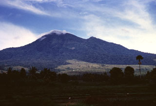 Gunung Seulawah Agam seen above farmlands on its eastern flank, is an extensively forested volcano of Pleistocene-Holocene age located in the province of Aceh at the NW tip of Sumatra. It was constructed within the large Pleistocene Lam Teuba caldera and a smaller nested 8 x 6 km caldera. Wispy clouds drape the summit, which contains a 400-m-wide crater. The van Heutsz crater on the NNE flank is one of several areas containing active fumarole fields.
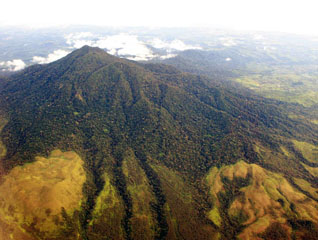 Seulawah Agam is seen here with the northern coast of Sumatra in the background. This extensively forested volcano of Pleistocene-Holocene age is located in the province of Aceh at the NW tip of Sumatra. It was constructed within the large Pleistocene Lam Teuba caldera and a smaller nested 8 x 6 km caldera. The summit contains a forested 400-m-wide crater.
The maps shown below have been scanned from the GVP map archives and include the volcano on this page. Clicking on the small images will load the full 300 dpi map. Very small-scale maps (such as world maps) are not included. The maps database originated over 30 years ago, but was only recently updated and connected to our main database. We welcome users to tell us if they see incorrect information or other problems with the maps; please use the Contact GVP link at the bottom of the page to send us email.
There are no samples for Seulawah Agam in the Smithsonian's NMNH Department of Mineral Sciences Rock and Ore collection.
| Copernicus Browser | The Copernicus Browser replaced the Sentinel Hub Playground browser in 2023, to provide access to Earth observation archives from the Copernicus Data Space Ecosystem, the main distribution platform for data from the EU Copernicus missions. |
| MIROVA | Middle InfraRed Observation of Volcanic Activity (MIROVA) is a near real time volcanic hot-spot detection system based on the analysis of MODIS (Moderate Resolution Imaging Spectroradiometer) data. In particular, MIROVA uses the Middle InfraRed Radiation (MIR), measured over target volcanoes, in order to detect, locate and measure the heat radiation sourced from volcanic activity. |
| MODVOLC Thermal Alerts | Using infrared satellite Moderate Resolution Imaging Spectroradiometer (MODIS) data, scientists at the Hawai'i Institute of Geophysics and Planetology, University of Hawai'i, developed an automated system called MODVOLC to map thermal hot-spots in near real time. For each MODIS image, the algorithm automatically scans each 1 km pixel within it to check for high-temperature hot-spots. When one is found the date, time, location, and intensity are recorded. MODIS looks at every square km of the Earth every 48 hours, once during the day and once during the night, and the presence of two MODIS sensors in space allows at least four hot-spot observations every two days. Each day updated global maps are compiled to display the locations of all hot spots detected in the previous 24 hours. There is a drop-down list with volcano names which allow users to 'zoom-in' and examine the distribution of hot-spots at a variety of spatial scales. |
|
WOVOdat
Single Volcano View Temporal Evolution of Unrest Side by Side Volcanoes |
WOVOdat is a database of volcanic unrest; instrumentally and visually recorded changes in seismicity, ground deformation, gas emission, and other parameters from their normal baselines. It is sponsored by the World Organization of Volcano Observatories (WOVO) and presently hosted at the Earth Observatory of Singapore.
GVMID Data on Volcano Monitoring Infrastructure The Global Volcano Monitoring Infrastructure Database GVMID, is aimed at documenting and improving capabilities of volcano monitoring from the ground and space. GVMID should provide a snapshot and baseline view of the techniques and instrumentation that are in place at various volcanoes, which can be use by volcano observatories as reference to setup new monitoring system or improving networks at a specific volcano. These data will allow identification of what monitoring gaps exist, which can be then targeted by remote sensing infrastructure and future instrument deployments. |
| Volcanic Hazard Maps | The IAVCEI Commission on Volcanic Hazards and Risk has a Volcanic Hazard Maps database designed to serve as a resource for hazard mappers (or other interested parties) to explore how common issues in hazard map development have been addressed at different volcanoes, in different countries, for different hazards, and for different intended audiences. In addition to the comprehensive, searchable Volcanic Hazard Maps Database, this website contains information about diversity of volcanic hazard maps, illustrated using examples from the database. This site is for educational purposes related to volcanic hazard maps. Hazard maps found on this website should not be used for emergency purposes. For the most recent, official hazard map for a particular volcano, please seek out the proper institutional authorities on the matter. |
| IRIS seismic stations/networks | Incorporated Research Institutions for Seismology (IRIS) Data Services map showing the location of seismic stations from all available networks (permanent or temporary) within a radius of 0.18° (about 20 km at mid-latitudes) from the given location of Seulawah Agam. Users can customize a variety of filters and options in the left panel. Note that if there are no stations are known the map will default to show the entire world with a "No data matched request" error notice. |
| UNAVCO GPS/GNSS stations | Geodetic Data Services map from UNAVCO showing the location of GPS/GNSS stations from all available networks (permanent or temporary) within a radius of 20 km from the given location of Seulawah Agam. Users can customize the data search based on station or network names, location, and time window. Requires Adobe Flash Player. |
| DECADE Data | The DECADE portal, still in the developmental stage, serves as an example of the proposed interoperability between The Smithsonian Institution's Global Volcanism Program, the Mapping Gas Emissions (MaGa) Database, and the EarthChem Geochemical Portal. The Deep Earth Carbon Degassing (DECADE) initiative seeks to use new and established technologies to determine accurate global fluxes of volcanic CO2 to the atmosphere, but installing CO2 monitoring networks on 20 of the world's 150 most actively degassing volcanoes. The group uses related laboratory-based studies (direct gas sampling and analysis, melt inclusions) to provide new data for direct degassing of deep earth carbon to the atmosphere. |
| Large Eruptions of Seulawah Agam | Information about large Quaternary eruptions (VEI >= 4) is cataloged in the Large Magnitude Explosive Volcanic Eruptions (LaMEVE) database of the Volcano Global Risk Identification and Analysis Project (VOGRIPA). |
| EarthChem | EarthChem develops and maintains databases, software, and services that support the preservation, discovery, access and analysis of geochemical data, and facilitate their integration with the broad array of other available earth science parameters. EarthChem is operated by a joint team of disciplinary scientists, data scientists, data managers and information technology developers who are part of the NSF-funded data facility Integrated Earth Data Applications (IEDA). IEDA is a collaborative effort of EarthChem and the Marine Geoscience Data System (MGDS). |

