Based on ground reports, satellite imagery, and wind model data, the Darwin VAAC reported that during 3 April an ash plume from Agung rose to 3.7 km (12,000 ft) a.s.l. The Alert Level remained at 1 (on a scale of 1-4).
Source: Darwin Volcanic Ash Advisory Centre (VAAC)
Three eruptive events reported in April, May, and December 2022
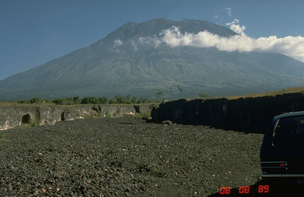
Mount Agung, located on the E end of the island of Bali, Indonesia, rises above the SE rim of the Batur caldera. The summit area extends 1.5 km E-W, with the highest point on the W and a steep-walled 800-m-wide crater on the E. Recorded eruptions date back to the early 19th century. A large and deadly explosive and effusive eruption occurred during 1963-64, which was characterized by voluminous ashfall, pyroclastic flows, and lahars that caused extensive damage and many fatalities. More recent activity was documented during November 2017-June 2019 that consisted of multiple explosions, significant ash plumes, lava flows at the summit crater, and incandescent ejecta. This report covers activity reported during April-May 2022 and December 2022 based on data from the Darwin Volcanic Ash Advisory Center (VAAC).
Activity during 2022 was relatively low and mainly consisted of a few ash plumes during April-May and December. An ash plume on 3 April rising to 3.7 km altitude (700 m above the summit) and drifting N was reported in a Darwin VAAC notice based on a ground report, with ash seen in HIMAWARI-8 visible imagery. Another ash plume was reported at 1120 on 27 May that rose to 5.5 km altitude (2.5 m above the summit); the plume was not visible in satellite or webcam images due to weather clouds. An eruption was reported based on seismic data at 0840 on 13 December, with an estimated plume altitude of 3.7 km; however, no ash was seen using satellite imagery in clear conditions before weather clouds obscured the summit.
Information Contacts: Darwin Volcanic Ash Advisory Centre (VAAC), Bureau of Meteorology, Northern Territory Regional Office, PO Box 40050, Casuarina, NT 0811, Australia (URL: http://www.bom.gov.au/info/vaac/).
2022: March
2021: September
2020: July
2019: February
| March
| April
| May
| June
2018: January
| February
| March
| April
| May
| June
| July
| August
2017: September
| October
| November
| December
Based on ground reports, satellite imagery, and wind model data, the Darwin VAAC reported that during 3 April an ash plume from Agung rose to 3.7 km (12,000 ft) a.s.l. The Alert Level remained at 1 (on a scale of 1-4).
Source: Darwin Volcanic Ash Advisory Centre (VAAC)
PVMBG reported that activity at Agung was last observed on 13 June 2019 and a thermal anomaly over the crater was last identified in satellite images in October 2019. During the previous year deformation data indicated no changes at the volcano and seismicity decreased. During 1 January-13 September white gas-and-steam plumes rose 20-50 m above the summit. On 13 September the Alert Level was lowered to 1 (on a scale of 1-4).
Source: Pusat Vulkanologi dan Mitigasi Bencana Geologi (PVMBG, also known as CVGHM)
PVMBG reported that the last eruption at Agung was recorded at 0138 on 13 June 2019. Over the past year seismicity had generally decreased; volcanic earthquakes continued to be recorded but at a low occurrence rate. Deformation data indicated a deflationary pattern which had stabilized in recent months. A thermal anomaly was last visible in satellite data in October 2019 and did not reappear. White plumes were visible rising 20-150 m above the summit during 1 January-16 July. PVMBG lowered the Alert Level at Agung to 2 (on a scale of 1-4) on 16 July, stating that the public should not enter an exclusion zone set at a 2-km radius.
Source: Pusat Vulkanologi dan Mitigasi Bencana Geologi (PVMBG, also known as CVGHM)
PVMBG reported that an eruption at Agung, recorded by the seismic network at 0138 on 13 June, ejected incandescent material onto the flanks. The Darwin VAAC stated that ash plumes rose to altitudes of 5.5 and 9.1 km (18,000 and 30,000 ft) a.s.l. and drifted W and SW, respectively, based on webcam views and satellite data. By 0635 the ash plume had detached and by 1505 it was about 370 km S of Agung. The Alert Level remained at 3 (on a scale of 1-4) with the exclusion zone set at a 4 km radius.
Source: Pusat Vulkanologi dan Mitigasi Bencana Geologi (PVMBG, also known as CVGHM)
PVMBG reported that at 1212 on 10 June an explosion at Agung produced a gray ash plume that rose about 1 km and drifted SE and E. The Alert Level remained at 3 (on a scale of 1-4) with the exclusion zone set at a 4-km radius.
Source: Pusat Vulkanologi dan Mitigasi Bencana Geologi (PVMBG, also known as CVGHM)
PVMBG reported that at 1142 on 31 May an explosion at Agung produced a dense gray ash plume that rose 2 km and drifted NE and E. Roaring was audible from the Agung Volcano Observatory in Rendang (about 8 km SW). The Alert Level remained at 3 (on a scale of 1-4) with the exclusion zone set at a 4-km radius.
Source: Pusat Vulkanologi dan Mitigasi Bencana Geologi (PVMBG, also known as CVGHM)
PVMBG reported that at 1923 on 24 May an explosion at Agung ejected incandescent material radially onto the flanks as far as 3 km from the crater rim, setting fire to some vegetation. A dense gray-white ash plume rose 2 km and, based on satellite data, drifted SW, causing thick ashfall in several villages to the S. Roaring was audible from the Agung Volcano Observatory in Rendang (about 8 km SW). According to a news article several flights to and from Australia were cancelled or diverted, though the International Gusti Ngurah Rai (IGNR) airport (60 km SW) in Denpasar was not closed. The Alert Level remained at 3 (on a scale of 1-4) with the exclusion zone set at a 4-km radius.
Sources: Pusat Vulkanologi dan Mitigasi Bencana Geologi (PVMBG, also known as CVGHM); Badan Nacional Penanggulangan Bencana (BNPB); The Jakarta Post
PVMBG reported that at 1409 on 18 May an explosion at Agung ejected incandescent material radially onto the flanks as far as 2.5 km from the crater rim. A dense gray-white ash plume rose 2 km and drifted NE, E, and SE, causing ashfall in hamlets downwind including Cutcut, Tongtongan, Bonyoh, and Temakung. A weak roar was audible from the Agung Volcano Observatory in Rendang (about 8 km SW). The Alert Level remained at 3 (on a scale of 1-4) with the exclusion zone set at a 4-km radius.
Source: Pusat Vulkanologi dan Mitigasi Bencana Geologi (PVMBG, also known as CVGHM)
PVMBG and BNPB reported that an eruptive event at Agung was recorded by the seismic network at 2229 on 12 May, accompanied by a loud bang audible at the Agung Volcano Observatory in Rendang (about 8 km SW). Dense fog prevented height estimates of the ash plume. A photo posted along with the report showed that incandescent material was deposited on the flanks. The Alert Level remained at 3 (on a scale of 1-4) with the exclusion zone set at a 4-km radius.
Source: Pusat Vulkanologi dan Mitigasi Bencana Geologi (PVMBG, also known as CVGHM)
PVMBG reported that an event at Agung was recorded by the seismic network at 1859 on 3 May. An ash plume was not visible from the Agung Volcano Observatory in Rendang (about 8 km SW), although the Darwin VAAC report a growing thermal anomaly and possible ash near the summit. About 30 minutes later the VAAC reported that an ash plume rose to 4.3 km (14,000 ft) a.s.l. and drifted NE; a thermal anomaly continued to be visible. On 6 May at 2255 a gray ash plume rose to around 2 km above the crater rim and drifted W. The Alert Level remained at 3 (on a scale of 1-4) with the exclusion zone set at a 4-km radius.
Source: Pusat Vulkanologi dan Mitigasi Bencana Geologi (PVMBG, also known as CVGHM)
PVMBG reported that at 0534 on 30 April a dense gray ash plume from Agung rose 1 km above the crater rim and drifted E. The Alert Level remained at 3 (on a scale of 1-4) with the exclusion zone set at a 4-km radius.
Source: Pusat Vulkanologi dan Mitigasi Bencana Geologi (PVMBG, also known as CVGHM)
PVMBG reported two explosive eruptions at Agung on 21 April. The first was recorded at 0321 and produced a dense gray ash plume that rose 2 km above the crater rim and drifted W and S. Ashfall was reported in areas downwind including Besakih (7 km SW), Rendang (12 km NW), Klungkung (~40 km S), Gianyar (20 km WSW), Bangli (17 km WNW), Tabanan (51 km WSW), and the International Gusti Ngurah Rai (IGNR) airport (60 km SW) in Denpasar. The second event was recorded at 1856 and generated a dense ash plume that rose 3 km and drifted S. Minor ashfall was reported in Besakih, Rendang, Sebudi (6 km SW), and Selat (12 km SSW). The eruptions were accompanied by a boom heard at both the Rendang and Batulompeh observation posts. Ejected incandescent material from the two events fell on the flanks in all directions within a radius of 4 km. The Alert Level remained at 3 (on a scale of 1-4) with the exclusion zone set at a 4-km radius.
Source: Pusat Vulkanologi dan Mitigasi Bencana Geologi (PVMBG, also known as CVGHM)
PVMBG reported that at 1847 on 11 April an explosion at Agung produced a dense gray ash plume that rose 2 km above the crater rim and drifted W. The Alert Level remained at 3 (on a scale of 1-4) with the exclusion zone set at a 4-km radius.
Source: Pusat Vulkanologi dan Mitigasi Bencana Geologi (PVMBG, also known as CVGHM)
PVMBG reported that at 1331 on 4 April an explosion at Agung ejected incandescent material out of the crater and onto the flanks within a 2-3 km radius, mainly on the S flank. A dense gray ash plume rose 2 km above the crater rim and, based on satellite data, drifted W and S. Ashfall was reported in areas downwind including Telungbuana, Badeg, Besakih (7 km SW), Pempatan (8 km W), Teges, and Puregai. Roaring was heard at the observation post in Rendang (12 km NW). The Alert Level remained at 3 (on a scale of 1-4) with the exclusion zone set at a 4-km radius.
Sources: Pusat Vulkanologi dan Mitigasi Bencana Geologi (PVMBG, also known as CVGHM); Darwin Volcanic Ash Advisory Centre (VAAC)
At 1825 on 28 March an ash plume from Agung rose above the crater to an altitude of 5.5 km (18,000 ft) a.s.l. and drifted NW according to PVMBG and the Darwin VAAC. A thermal anomaly was visible in satellite data. Ashfall was reported in nearby villages. The Alert Level remained at 3 (on a scale of 1-4) with the exclusion zone set at a 4-km radius.
Source: Pusat Vulkanologi dan Mitigasi Bencana Geologi (PVMBG, also known as CVGHM)
PVMBG reported that at 0018 on 21 March an event at Agung was recorded for 1 minute and 47 seconds by the seismic network. Weather conditions prevented visual observations of the summit. The Alert Level remained at 3 (on a scale of 1-4) with the exclusion zone set at a 4-km radius.
Source: Pusat Vulkanologi dan Mitigasi Bencana Geologi (PVMBG, also known as CVGHM)
PVMBG reported that at 1827 on 15 March an explosive event at Agung was recorded for one minute and 23 seconds and produced a dense gray ash plume that rose about 1 km above the crater rim and drifted NNW. Minor ashfall was reported in the villages of Kubu (6 km N), Tianyar (14 km NNW), Ban, Kadundung, and Sukadana. At 0803 on 17 March an event was recorded for 39 seconds and produced a dense gray ash plume that rose about 500 m above the crater rim and drifted E. A second event began at 1030 and lasted about one minute and 16 seconds; a dense gray ash plume rose about 600 m and drifted E. At 0736 on 18 March an ash plume rose 1 km and drifted W and NW. Thermal satellite images continue to indicate hot areas in the crater on the previously-erupted lava surface especially near the flow margins. The Alert Level remained at 3 (on a scale of 1-4) with the exclusion zone set at a 4-km radius.
Source: Pusat Vulkanologi dan Mitigasi Bencana Geologi (PVMBG, also known as CVGHM)
PVMBG reported that at 0452 on 4 March an event at Agung was recorded for just under three minutes and produced ashfall in Besakih (7 km SW) around 0615. No ash plume was visible although foggy conditions prevented views of the summit. An event that began at 0047 on 9 March lasted for 3 minutes and 50 seconds, and produced an ash plume that drifted E. The Alert Level remained at 3 (on a scale of 1-4) with the exclusion zone set at a 4-km radius.
Source: Pusat Vulkanologi dan Mitigasi Bencana Geologi (PVMBG, also known as CVGHM)
PVMBG reported that at 1631 on 22 February an event at Agung generated an ash plume that rose 700 m and drifted E. The Alert Level remained at 3 (on a scale of 1-4) with the exclusion zone set at a 4-km radius.
Source: Pusat Vulkanologi dan Mitigasi Bencana Geologi (PVMBG, also known as CVGHM)
PVMBG reported that an explosive event at Agung was recorded at 0434 on 14 February, causing ashfall in Bugbug village, 20 km SE. Crater incandescence was recorded at night by webcams in Karangasem City (16 km SE). The Alert Level remained at 3 (on a scale of 1-4) with the exclusion zone set at a 4-km radius.
Source: Pusat Vulkanologi dan Mitigasi Bencana Geologi (PVMBG, also known as CVGHM)
PVMBG reported that a 97-second-long explosive event at Agung began at 0012 on 8 February. A plume was not visible, though webcams recorded crater incandescence. The Alert Level remained at 3 (on a scale of 1-4) with the exclusion zone set at a 4-km radius.
Source: Pusat Vulkanologi dan Mitigasi Bencana Geologi (PVMBG, also known as CVGHM)
According to the Darwin VAAC, a webcam recorded a diffuse ash emission from Agung rising to an altitude of 3.3 km (11,000 ft) a.s.l. and drifting W on 17 August. The Alert Level remained at 3 (on a scale of 1-4) and the exclusion zone was stable at a 4-km radius.
Source: Darwin Volcanic Ash Advisory Centre (VAAC)
According to the Darwin VAAC, a webcam recorded an ash emission from Agung rising to an altitude of 4.3 km (14,000 ft) a.s.l. and drifting W. The Alert Level remained at 3 (on a scale of 1-4) with the exclusion zone set at a 4-km radius.
Sources: Darwin Volcanic Ash Advisory Centre (VAAC); Pusat Vulkanologi dan Mitigasi Bencana Geologi (PVMBG, also known as CVGHM)
PVMBG reported that white plumes rose 100-300 m above Agung’s crater rim during 1 and 2-7 August. The Alert Level remained at 3 (on a scale of 1-4) with the exclusion zone set at a 4-km radius.
Source: Pusat Vulkanologi dan Mitigasi Bencana Geologi (PVMBG, also known as CVGHM)
According to PVMBG a ground-based observer reported that at 0041 on 25 July an event at Agung produced a dense ash-and-gas plume that rose 700 m and drifted E and SE. Seismic data recorded the event for two minutes and 15 seconds. At 1406 on 27 July an event lasting one minute and 32 seconds produced a dense ash-and-gas plume that rose 2 km and drifted W. The Alert Level remained at 3 (on a scale of 1-4) and the exclusion zone was stable at a 4-km radius.
Source: Pusat Vulkanologi dan Mitigasi Bencana Geologi (PVMBG, also known as CVGHM)
PVMBG reported that plumes rose 200-500 m above Agung’s crater rim on 18, 20, and 23 July. Gray plumes rose as high as 1.5 km on 22 July. The Alert Level remained at 3 (on a scale of 1-4) and the exclusion zone was stable at a 4-km radius.
Source: Pusat Vulkanologi dan Mitigasi Bencana Geologi (PVMBG, also known as CVGHM)
PVMBG reported that an event at 1409 on 13 July generated an ash plume that rose 1.5 km above Agung’s crater rim and drifted W. An event was detected at 0452 on 15 July, though no ash was visible. An ash plume from an event at 0905 rose 1.5 km and drifted W and SE. The Alert Level remained at 3 (on a scale of 1-4) and the exclusion zone was unchanged at a 4-km radius.
Source: Pusat Vulkanologi dan Mitigasi Bencana Geologi (PVMBG, also known as CVGHM)
PVMBG reported that the eruption at Agung continued during 4-10 July. Sulfur dioxide flux was 1,400-2,400 tons/day on 3 July and 400-1,500 tons/day on 4 July. Satellite data acquired on 4 July indicated continuing lava effusion in the crater, with 4-5 million cubic meters effused in the past week. At 1220 an ash plume rose 2.5 km above the crater rim and drifted W. An event was detected at 2216, though an ash plume was not visible possibly due to poor viewing conditions. At 0047 on 5 July an ash plume rose at least 1 km and drifted W, and an event at 1633 produced an ash plume that rose 2.8 km and drifted E and W. A small event was detected on 6 July. According to BNPB a third Strombolian event occurred at 0522 on 8 July, generating an ash plume that rose 2 km. They noted that 4,415 evacuees were housed in 54 evacuation centers. An ash plume rose from the crater at 1120 on 9 July and drifted W. The Alert Level remained at 3 (on a scale of 1-4) and the exclusion zone was stable at a 4-km radius.
Sources: Pusat Vulkanologi dan Mitigasi Bencana Geologi (PVMBG, also known as CVGHM); Badan Nacional Penanggulangan Bencana (BNPB)
PVMBG reported that seismicity at Agung continued to be dominated by low-frequency events. The number of earthquakes increased from 15/day on 25 June to 69/day on 28 June; harmonic tremor emerged on 27 June, and at 2221 an event generated an ash plume that rose 2 km above the crater rim and drifted W. Gas-and-ash emissions were continuous during 28-29 June, rising around 2 km and drifting W and SW, and incandescence was reflected in the plume; satellite data confirmed that high-temperature (1,200 degrees Celsius) lava flowed onto the crater floor. The intensity of the thermal anomaly on 29 June was the largest recorded at Agung since the beginning of the eruption on 21 November 2017.
BNPB noted that the ash plumes on 28 June caused some airlines to cancel flights to Bali, and ashfall was reported in several villages on Bangli. The International Gusti Ngurah Rai (IGNR) airport (60 km SW) in Denpasar, the Blimbing Sari Airport (128 km W) in Banyuwangi, and the Noto Hadinegoro Airport (200 km W) in Jember closed for portions of the day on 29 June.
Lava continued to effuse, and by 1 July the estimated volume of new lava was 4-5 million cubic meters making the total volume erupted since 21 November 2017 around 27-28 million cubic meters (50% of the total crater volume). The height difference between the lowest part of the crater rim (SW side) and the highest part of the lava surface (in the center of the crater) was 85-90 m. Satellite data showed that the intensity of the thermal anomaly decreased during 28 June-2 July, though still remained at a high level. At 2104 on 2 July an explosion generated an ash plume that rose 7-9 km above the crater rim, and ejected incandescent lava as far as 2 km onto the flanks. News articles noted that the deposits caused forest fires on the upper flanks, and that the event prompted about 700 people to evacuate. An event at 0413 on 3 July generated an ash plume that rose around 2 km. The Alert Level remained at 3 (on a scale of 1-4) and the exclusion zone was stable at a 4-km radius.
Sources: Pusat Vulkanologi dan Mitigasi Bencana Geologi (PVMBG, also known as CVGHM); Badan Nacional Penanggulangan Bencana (BNPB); Associated Press
PVMBG reported that at 1105 on 13 June an event at Agung produced a dense ash plume that rose around 2 km above the crater rim and drifted SW and W. Based on analysis of the seismic data, the event lasted two minutes and 12 seconds. Another event was detected at 2115 on 15 June, though foggy conditions prevented estimations of the ash plume height; ash fell in areas W, including in Puregai (7 km W). The Alert Level remained at 3 (on a scale of 1-4) and the 4-km-radius exclusion zone was unchanged.
Source: Pusat Vulkanologi dan Mitigasi Bencana Geologi (PVMBG, also known as CVGHM)
PVMBG reported that during 1 May-7 June activity at Agung remained at a relatively high level. Emissions were mostly water vapor, occasionally with ash. In general, tiltmeter and GPS showed long-term deflation since December 2017, though inflation began to be detected the second week of May; deformation analysis indicated that magma continued to accumulate about 3-4 km below the crater. Low- and high-frequency earthquakes also suggested rising magma. Sulfur dioxide flux was 190-203 tons/day, and thermal anomalies in the crater were identified in satellite data. The erupted volume of lava was estimated to be 23 million cubic meters, equivalent to about a third of the total crater volume. At 2214 on 10 June an event generated an ash plume that drifted W at an unspecified altitude. The Alert Level remained at 3 (on a scale of 1-4) and the exclusion zone was stable at a 4-km radius.
Source: Pusat Vulkanologi dan Mitigasi Bencana Geologi (PVMBG, also known as CVGHM)
PVMBG reported that although there were some periods of foggy conditions during 23-29 May, white plumes were occasionally observed rising as high as 400 m above Agung’s crater rim. At 0539 on 29 May an event generated an ash plume that rose 500 m above the crater rim and drifted SW. The Alert Level remained at 3 (on a scale of 1-4) and the exclusion zone continued at a 4-km radius.
Source: Pusat Vulkanologi dan Mitigasi Bencana Geologi (PVMBG, also known as CVGHM)
PVMBG reported that at 1719 on 19 May an event at Agung generated an ash plume that rose 1 km above the crater rim and drifted SE. The Alert Level remained at 3 (on a scale of 1-4) and the exclusion zone continued at a 4-km radius.
Source: Pusat Vulkanologi dan Mitigasi Bencana Geologi (PVMBG, also known as CVGHM)
PVMBG reported that at 2245 on 30 April an event at Agung generated an ash plume that rose 1.5 km above the crater rim and drifted SW. Seismicity was dominated by low-frequency earthquakes related to gas-and-steam emissions. The Alert Level remained at 3 (on a scale of 1-4) and the exclusion zone continued at a 4-km radius.
Source: Pusat Vulkanologi dan Mitigasi Bencana Geologi (PVMBG, also known as CVGHM)
PVMBG reported that although there were often foggy conditions during 18-24 April, white plumes were observed rising as high as 300 m above Agung’s crater rim and drifting E. The Alert Level remained at 3 (on a scale of 1-4) and the exclusion zone continued at a 4-km radius.
Source: Pusat Vulkanologi dan Mitigasi Bencana Geologi (PVMBG, also known as CVGHM)
Based on webcam views, satellite data, and ground-based observations, the Darwin VAAC reported that on 11 April an event at Agung generated an ash plume that rose to an altitude of 3.7 km (12,000 ft) a.s.l. and drifted SW.
Sources: Darwin Volcanic Ash Advisory Centre (VAAC); Pusat Vulkanologi dan Mitigasi Bencana Geologi (PVMBG, also known as CVGHM)
PVMBG reported that an event at Agung at 1737 on 5 April generated an ash plume that rose 500 m above the crater rim and drifted W. Seismicity was dominated by high- and low-frequency earthquakes. The Alert Level remained at 3 (on a scale of 1-4) and the exclusion zone continued at a 4-km radius.
Source: Pusat Vulkanologi dan Mitigasi Bencana Geologi (PVMBG, also known as CVGHM)
In a VONA, PVMBG reported that at 1009 on 26 March an event at Agung generated an ash plume that rose at least to an altitude of 3.6 km (11,650 ft) a.s.l. and drifted NW. The Alert Level remained at 3 (on a scale of 1-4) and the exclusion zone continued at a 4-km radius.
Source: Pusat Vulkanologi dan Mitigasi Bencana Geologi (PVMBG, also known as CVGHM)
PVMBG reported that although there were sometimes foggy conditions during 7-13 March, white plumes were observed rising as high as 600 m above Agung’s crater rim and drifting E. An event at 2332 on 11 March generated an ash plume that rose about 950 m and drifted E. The Alert Level remained at 3 (on a scale of 1-4) and the exclusion zone continued at a 4-km radius.
Source: Pusat Vulkanologi dan Mitigasi Bencana Geologi (PVMBG, also known as CVGHM)
PVMBG reported that on 28 February gray-white plumes rose as high as 300 m above Agung’s crater rim. During 1-5 March white plumes rose as high as 500 m above the crater rim. The Alert Level remained at 3 (on a scale of 1-4) and the exclusion zone continued at a 4-km radius.
Source: Pusat Vulkanologi dan Mitigasi Bencana Geologi (PVMBG, also known as CVGHM)
PVMBG reported that an event at Agung recorded at 1149 on 13 February generated an ash plume that rose to an altitude of 4.5 km (14,900 ft) a.s.l. and drifted E. The Alert Level remained at 3 (on a scale of 1-4) and the exclusion zone continued at a 4-km radius.
Source: Pusat Vulkanologi dan Mitigasi Bencana Geologi (PVMBG, also known as CVGHM)
On 10 February PVMBG reported that activity at Agung had declined during the previous month or two leading the observatory to lower the Alert Level to 3 (on a scale of 1-4) and adjusted the exclusion zone to a 4-km radius. The report noted that the tallest eruption plume in January was 2.5 km above the crater rim, occurring on 19 January, and the last event on 24 January generated a plume that rose 1 km. The volume of erupted lava was an estimated 20 million cubic meters in December 2017, and had not significantly changed. Seismicity continued to fluctuate, though the number and magnitude of events had declined. Satellite data showed a decrease in thermal output reflective of a reduced lava flow rate. PVMBG warned that activity at Agung is still high and unstable; tiltmeter data showed low rates of inflation (GPS patterns were stable) and gas-emission data indicated magma movement at depth, though at a lower intensity compared to values measured at the end of November 2017. An event at 1149 on 13 February generated as ash plume that rose 1.5 km above the crater rim.
Source: Pusat Vulkanologi dan Mitigasi Bencana Geologi (PVMBG, also known as CVGHM)
PVMBG reported that white-and-gray plumes rose as high as 1 km above Agung’s crater rim during 24-25 January. Foggy conditions prevented visual observations of the crater during 26-30 January. The Alert Level remained at 4 (on a scale of 1-4) and the exclusion zone continued at a 6-km radius.
Source: Pusat Vulkanologi dan Mitigasi Bencana Geologi (PVMBG, also known as CVGHM)
PVMBG reported that the eruption at Agung continued during 17-23 January, with gas-and-steam plumes rising from the crater punctuated by occasional ash emissions. An event at 2126 on 17 January generated a plume that rose 1.5 km above the crater rim and drifted E. An event was recorded at 1944 on 18 January, though fog prevented confirmation of a plume. At 1920 on 19 January a Strombolian event produced an ash plume that rose as high as 2.5 km and drifted E, and ejected incandescent material as far as 1 km from the crater. Incandescence emanated from the crater for about two hours after the event. White-to-gray plumes rose 500 m during 22-23 January. The Alert Level remained at 4 (on a scale of 1-4) and the exclusion zone continued at a 6-km radius.
Sources: Pusat Vulkanologi dan Mitigasi Bencana Geologi (PVMBG, also known as CVGHM); Badan Nacional Penanggulangan Bencana (BNPB)
PVMBG reported that during 10-16 January gray-and-white plumes generally rose as high as 500 m above Agung’s crater rim and drifted S, SE, and E. An event at 1754 on 11 January produced an ash plume that rose 2.5 km above the crater rim and drifted NE (likely causing ashfall in areas downwind), and another event at 0723 on 15 January generated an ash plume that rose 2 km. As of 11 January BNPB estimated that 53,207 evacuees were spread out in 233 shelters. The Alert Level remained at 4 (on a scale of 1-4) and the exclusion zone continued at a 6-km radius.
Sources: Pusat Vulkanologi dan Mitigasi Bencana Geologi (PVMBG, also known as CVGHM); Badan Nacional Penanggulangan Bencana (BNPB)
BNPB reported that activity at Agung continued to fluctuate at a high level. Visual observations as well as seismic, deformation, and geochemistry data indicated that the eruption was continuing, though deformation data in recent days showed a stagnant trend. As of the morning of 4 January BNPB noted that there were 70,610 evacuees spread out in 240 shelters. The exclusion zone was adjusted to 6 km in all directions that same day, allowing thousands of displaced people the option to return to their homes. An estimated 17,115 people in seven villages have residences within the 6-km-radius exclusion zone.
PVMBG reported that during 3-9 January gray-and-white plumes rose as high as 2 km above the crater rim and drifted in multiple directions. The Alert Level remained at 4 (on a scale of 1-4).
Sources: Badan Nacional Penanggulangan Bencana (BNPB); Pusat Vulkanologi dan Mitigasi Bencana Geologi (PVMBG, also known as CVGHM)
PVMBG reported that during 27 December 2017-2 January 2018 gray-and-white plumes rose as high as 2 km above Agung’s crater rim and drifted W, SW, and E. Incandescence from the crater was often observed at night. Ash fell in several local villages including Badeg, Yeha, Temukus, Besakih (11 km WSW), and Muncan (12 km SW) on 1 January, and Rendang post on 2 January. The Alert Level remained at 4 (on a scale of 1-4), and the exclusion zones continued at a general 8-km radius and 10 km in the NNE, SE, S, and SW directions.
Sources: Pusat Vulkanologi dan Mitigasi Bencana Geologi (PVMBG, also known as CVGHM); Badan Nacional Penanggulangan Bencana (BNPB)
PVMBG reported that during 20-26 December gray-and-white plumes rose as high as 2 km above Agung’s crater rim and drifted W and E; weather clouds and fog sometimes prevented visual observations. Incandescence from the crater was sometimes observed at night. BNPB reported that during 22-23 December events generated dense gray ash plumes that rose as high as 2.5 km above the crater rim and drifted NE. Ash fell on the flanks and in Tulamben, Kubu. As of 25 December there were 71,045 evacuees spread out in 239 shelters. The Alert Level remained at 4 (on a scale of 1-4), and the exclusion zones continued at a general 8-km radius and 10 km in the NNE, SE, S, and SW directions.
Sources: Pusat Vulkanologi dan Mitigasi Bencana Geologi (PVMBG, also known as CVGHM); Badan Nacional Penanggulangan Bencana (BNPB)
PVMBG reported that during 13-19 December gray-and-white plumes rose as high as 2.5 km above Agung’s crater rim and drifted W, N, and E; weather clouds and fog sometimes prevented visual observations. Incandescence from the crater was sometimes observed at night. The Alert Level remained at 4 (on a scale of 1-4), and the exclusion zones continued at a general 8-km radius and 10 km in the NNE, SE, S, and SW directions.
BNPB posted two map-view images of Agung, one from 20 October showing pre-eruptive conditions and one from 16 December showing the lava that had erupted onto the crater floor, noting that about 1/3 of the crater had been filled with an estimated 20 million cubic meters of lava.
Sources: Pusat Vulkanologi dan Mitigasi Bencana Geologi (PVMBG, also known as CVGHM); Badan Nacional Penanggulangan Bencana (BNPB)
Based on BNPB and PVMBG reports, the eruption at Agung continued during 6-12 December, with high seismicity and nighttime crater incandescence often visible. On 8 December at 0759 an event generated a dense ash plume that rose 2.1 km above the crater rim and drifted W. Minor amounts of ash were deposited on the flanks, and lapilli was reported in Temakung. An ash plume rose 3 km at 1457. The number of evacuees on 10 December was 70,079 (spread out in 237 shelters). Ash plumes rose as high as 2 km. Lahars were observed in a drainage originating on the flanks of Agung. An explosion at 0549 on 11 December generated a dense ash plume that rose 2.5 km and drifted W and NW. Multiple ash-plume events were observed during 11-12 December, with plumes rising 1.5 km above the crater rim. The Alert Level remained at 4 (on a scale of 1-4), and the exclusion zones continued at a general 8-km radius and 10 km in the NNE, SE, S, and SW directions.
Sources: Pusat Vulkanologi dan Mitigasi Bencana Geologi (PVMBG, also known as CVGHM); Badan Nacional Penanggulangan Bencana (BNPB)
PVMBG reported that the eruption at Agung, which began on 21 November, continued during 30 November-5 December. On 29 November gray ash plumes levels were rising to 2 km above the crater rim, resulting in ashfall to the SE. During 30 November-5 December emissions continued to rise 2 km; most were white in color, but dense gray ash emissions were noted during 1-2 December. Satellite data indicated that lava effusion continued at least through 1 December, and the erupted volume of lava was estimated to be 20 million cubic meters, equivalent to about a third of the total crater volume. The base of the plume was often reddish during 29 November-5 December reflecting incandescence from lava in the crater. BNPB noted on 5 December that 63,885 evacuees were distributed in 225 evacuation shelters.
Lahars were first noted on 21 November and continued to be observed through 5 December. The lahars flowed down drainages on the S flank (along the Tukad Yehsa, Tukad Sabuh, and Tukad Beliaung drainages) and also down the Tukad Bara drainage on the N flank, impacting houses, roads, and agricultural areas. The Alert Level remained at 4 (on a scale of 1-4), and the exclusion zones continued at a general 8-km radius and 10 km in the NNE, SE, S, and SW directions.
Sources: Pusat Vulkanologi dan Mitigasi Bencana Geologi (PVMBG, also known as CVGHM); Badan Nacional Penanggulangan Bencana (BNPB)
PVMBG reported that at 1730 on 25 November, after the number of volcanic earthquakes significantly increased, ash plumes rose 1.5 km above Agung’s crater rim and drifted 12 km WSW. Ashfall was reported in areas SW including Besakih (7 km SW), hamlets in the upper part of Pempatan (7.5 km W), and Temukus, prompting remaining residents to evacuate to the S. Eight inbound and 13 outbound international flights were cancelled, affecting 2,087 passengers. Crater incandescence was observed at 2100, signifying the presence of lava in the crater. BNPB noted that the number of evacuees was 25,016 (spread out in 224 shelters)
On 26 November dark gray ash plumes rose 2 km at 0505, 3 km at 0545, and 4 km at 0620, and drifted E and SE. Ash emissions continued throughout the day; a few explosions were heard within a 12-km radius. PVMBG issued a Volcano Observatory Notice for Aviation (VONA) elevating the Aviation Color Code from Orange to Red. Satellite data recorded sulfur dioxide gas concentrations ranging from 1,000 to 2,000 tons/day. Ashfall was reported in several areas downwind including North Duda (9 km S), Duda Timur (12 km S), Pempetan, Besakih, Sideman (15 km SSW), Tirta Abang, Sebudi (6 km SW), Amerta Bhuana (10 km SSW) in Klungkung, and some villages in Gianyar (20 km WSW). Ashfall was the thickest (5 mm) in Sibetan (11.5 km S). News sources noted that Lombok International Airport closed during 26-27 November.
PVMBG raised the Alert Level to 4 (the highest level on a scale of 1-4) on 27 November, and the exclusion zones were expanded to a general 8-km radius and to 10 km in the NNE, SE, S, and SW directions. Dense ash plumes continued to rise 2-4 km above the crater rim. Based on satellite data, the Darwin VAAC reported that ash plumes rose as high as 9.1 km (30,000 ft) a.s.l., or just over 6 km above the crater rim. Pictures and video showed a white steam plume adjacent to a gray ash plume rising form the crater, signifying two distinct active vents. According to news articles the Ngurah Rai International Airport in Bali closed due to the airborne ash. On 28 November BNPB noted that the number of evacuees had increased to 38,678, and were distributed in 225 evacuation centers. The Ngurah Rai International Airport reopened on 29 November, after the Aviation Color Code was lowered to Orange.
Sources: Pusat Vulkanologi dan Mitigasi Bencana Geologi (PVMBG, also known as CVGHM); Badan Nacional Penanggulangan Bencana (BNPB); Darwin Volcanic Ash Advisory Centre (VAAC); CNN; The Sun
PVMBG reported that a phreatic eruption at Agung began at 1705 on 21 November, following a low-frequency tremor signal. An ash plume rose 700 m above the crater rim and drifted ESE. The Alert Level remained at 3 (on a scale of 1-4), and the exclusion zones remained intact (at 6 km, and an additional expansion to 7.5 km in the NNE, SE, S, and SW directions).
Sources: Pusat Vulkanologi dan Mitigasi Bencana Geologi (PVMBG, also known as CVGHM); Badan Nacional Penanggulangan Bencana (BNPB)
PVMBG reported that white plumes from Agung rose as high as 500 m above the crater rim during 8-14 November. The Alert Level remained at 3 (on a scale of 1-4), and the exclusion zones remained intact (at 6 km, and an additional expansion to 7.5 km in the NNE, SE, S, and SW directions).
Source: Pusat Vulkanologi dan Mitigasi Bencana Geologi (PVMBG, also known as CVGHM)
PVMBG reported that white plumes from Agung rose as high as 500 m above the crater rim during 1-7 November. The Alert Level remained at 3 (on a scale of 1-4), and the exclusion zones remained at 6 km, with an additional expansion to 7.5 km in the NNE, SE, S, and SW directions.
Source: Pusat Vulkanologi dan Mitigasi Bencana Geologi (PVMBG, also known as CVGHM)
On 29 October PVMBG lowered the Alert level for Agung to 3 (on a scale of 1-4), noting a decline in activity, especially since 20 October. The thermal anomaly in the crater identified in satellite data was less intense in October than in September. Beginning on 20 October GPS data showed a slower deformation rate. Seismic signals decreased in number and amplitude, though low-frequency events continued to indicate magma movement. White fumarolic plumes rose as high as 500 m above the crater rim during 20-29 October; a comparison of video taken by drones on 20 and 29 October showed a relative decrease in the intensity of fumarolic emissions. BNPB stated that, despite the decreased Alert Level, the exclusion zones remained intact (at 6 km, and an additional expansion to 7.5 km in the NNE, SE, S, and SW directions). The number of evacuees was 133,457 (spread out in 385 shelters).
Sources: Pusat Vulkanologi dan Mitigasi Bencana Geologi (PVMBG, also known as CVGHM); Badan Nacional Penanggulangan Bencana (BNPB)
PVMBG reported that although foggy conditions at Agung occasionally prevented visual observations, during 18-24 October dense white plumes were seen rising as high as 500 m above the crater rim. Seismicity fluctuated but remained high, though BNPB reported that overall seismicity had decreased. According to BNPB a team launched a drone on 19 October and were able to capture video of the fumarolic emissions from several vents and cracks in the crater. The Alert Level remained at 4 (the highest level on a scale of 1-4) with the exclusion zone at 9 km, and an additional expansion to 12 km in the SE, S, and SW directions.
Sources: Pusat Vulkanologi dan Mitigasi Bencana Geologi (PVMBG, also known as CVGHM); Badan Nacional Penanggulangan Bencana (BNPB)
PVMBG reported that although foggy conditions at Agung sometimes prevented visual observations, during 11-17 October dense white plumes were seen rising 200 m above the crater rim. On 14 October BNPB stated that seismicity remained high; PVMBG noted that seismicity was dominated by shallow volcanic events, and the number of volcanic earthquakes remained steady. The governor of Bali extended the state of emergency to 26 October, noting that the Alert Level remained at 4 (the highest level on a scale of 1-4). The number of evacuees was 139,199 (spread out in 389 shelters).
Sources: Pusat Vulkanologi dan Mitigasi Bencana Geologi (PVMBG, also known as CVGHM); Badan Nacional Penanggulangan Bencana (BNPB)
On 5 October PVMBG reported that the rate of volcanic earthquakes at Agung had not increased during the previous 12 days, but continued to fluctuate at a high level. The seismic network detected 1-3 earthquakes per minute on average, with a total more than 600 events per day. The number of shallow volcanic earthquakes increased to 200 per day during 24 September-5 October, possibly indicating that magmatic activity at shallow depths was still high. The number of earthquakes felt by staff at the Mt. Agung Volcano Observatory in Rendang village, 12.5 km SSW, peaked on 27 September and then decreased afterwards. Gas plumes rose 50-200 m above the crater rim. Satellite data indicated an area of water expulsion near the solfatara field on the crater floor thought to reflect a disturbance to the hydrologic system in response to intruded magma at depth. On 5 October BNPB reported that the number of evacuees reached 146,797 (spread out in 427 shelters), though about 28 villages (70,000 people) were located within the evacuation zone. About 10,000 farm animals had also been evacuated. On 7 October a white plume likely composed mostly of water vapor rose 1.5 km above the crater rim and slowly drifted E. During 8-10 October fumarolic plumes rose 50-200 m above the rim. The Alert Level remained at 4 (the highest level on a scale of 1-4) with the exclusion zone at 9 km, and an additional expansion to 12 km in the SE, S, and SW directions.
Sources: Pusat Vulkanologi dan Mitigasi Bencana Geologi (PVMBG, also known as CVGHM); Badan Nacional Penanggulangan Bencana (BNPB)
On 29 September PVMBG reported that earthquakes at Agung were becoming stronger with more felt by local residents, and larger ones felt in areas 45-55 km SW including Denpasar and Kuta. Fumarolic emissions were identified in satellite data, as well as hot areas on the crater floor that had enlarged over the previous week. A new fracture on the crater floor emitted steam. After a M 4.2 earthquake was detected at 1627 on 26 September emissions intensified and rose 500 m above the crater rim. On 4 October BNPB reported that seismicity continued to fluctuate at high levels, and weak emissions rose above the crater rim. The number of evacuees reached 141,213 (spread out in 416 shelters) from 78 villages, though about 2,600 in locations outside of the evacuation zone were returning home; there were 28 villages (about 70,000 people) within the evacuation zone. The Alert Level remained at 4 (the highest level on a scale of 1-4) with the exclusion zone at 9 km, and an additional expansion to 12 km in the SE, S, and SW directions.
Sources: Pusat Vulkanologi dan Mitigasi Bencana Geologi (PVMBG, also known as CVGHM); Badan Nacional Penanggulangan Bencana (BNPB)
BNPB noted that as of 1300 on 22 September there were 9,421 people displaced from the evacuation zones at Agung. Seismicity continued to increase, therefore later that day on 22 September PVMBG raised the Alert Level to 4 (the highest level on a scale of 1-4) and expanded the exclusion zone to 9 km, with an additional expansion to 12 km in the SE, S, and SW directions. On 24 September BNPB reported that the number of evacuees continued to grow, as residents were leaving the expanded evacuation zones; there were 34,931 people in 238 shelters. The report noted that some people were returning home in the daytime to feed their livestock. On 27 September the number of evacuees reached 96,086 (spread out in 430 shelters), seismic activity continued to escalate, and diffuse white plumes rose 50 m above the crater rim.
Sources: Badan Nacional Penanggulangan Bencana (BNPB); Pusat Vulkanologi dan Mitigasi Bencana Geologi (PVMBG, also known as CVGHM)
Increased seismicity at Agung, as well as the severity of past eruptions, prompted PVMBG to raise the Alert Level to 2 (on a scale of 1-4). The report noted that volcanic earthquakes (VA) began to be recorded on 10 August and shallow volcanic earthquakes (VB) began to be recorded on 24 August. Local tectonic earthquakes were also recorded and began to increase consistently on 26 August. PVMBG warned the public to stay at least 3 km away from the crater. On 13 September a climber observed a sulfatara plume rising from the bottom of the crater as high as 50 m above the crater rim. During 14-18 September four earthquakes centered around Agung were felt. On 18 September PVMBG reported that the number of VA and VB events continued to increase; the Alert Level was increased to 3. The exclusion zone was increased to 6 km, with an additional expansion to 7.5 km in the N, SE, and SSW directions. Elevations above 950 m were also restricted.
A VEI 5 eruption during 1963-64 produced pyroclastic flows and lahars that caused extensive damage and resulted in more than 1,100 deaths.
Source: Pusat Vulkanologi dan Mitigasi Bencana Geologi (PVMBG, also known as CVGHM)
Reports are organized chronologically and indexed below by Month/Year (Publication Volume:Number), and include a one-line summary. Click on the index link or scroll down to read the reports.
Fumarolic activity
Fumarolic and solfataric activity (restricted to the crater) emitted a thin white plume periodically seen from the observatory. In late July, 69 tectonic, three volcanic A-type, and six volcanic B-type events were recorded.
Information Contacts: VSI.
Occasional seismicity but solfatara field quiet
Observations from both Rendang (S) and Budakeling (N) Observatories revealed neither white plumes from the solfatara field nor collapses of loose material from the inner crater wall. No explosion sounds from the crater have been heard. An earthquake was felt (MM I) on 9 June; 59 tectonic and two volcanic shocks [were] recorded in November.
Information Contacts: VSI.
Hot-spots located outside the summit crater are most likely due to fires
Thermal anomalies were detected by MODIS throughout 2001 and 2002 in zones proximal to the summit of Agung. The first alert occurred on 23 September 2001 when two alert-pixels were detected with a maximum alert ratio of -0.789. Larger anomalies were detected on 12 August 2002 (two alert-pixels with maximum alert ratio of -0.429) and 5 October 2002 (one alert-pixel with alert ratio of -0.536). All the alerts seem to occur outside the summit crater, with the possible exception of 5 October 2002, and are more likely to represent fires than volcanic activity.
No volcanic activity has been reported recently by the Volcanological Survey of Indonesia.
Information Contacts: Diego Coppola and David A. Rothery, Department of Earth Sciences, The Open University, Milton Keynes, MK7 6AA, UK. Thermal alerts courtesy of the HIGP MODIS Thermal Alerts Team (URL: http://modis.higp.hawaii.edu/).
New eruption after 54 years; extensive pre-eruption seismicity precedes ash emission on 21 November 2017
A large explosive and effusive eruption lasting about 11 months during 1963-64 at Indonesia's Mount Agung on Bali produced voluminous ashfall, devastating pyroclastic flows that caused extensive damage, and over 1,000 fatalities. The volcano remained largely quiet until renewed seismicity began in August 2017, the prelude to a new eruptive episode, which started in late November 2017 and is ongoing. Self and Rampino (2012) and Fontijn et al. (2015) published detailed summaries of historical activity at Agung prior to this new episode; a brief summary of their work is provided.
Information about the new eruptive episode comes from Pusat Vulkanologi dan Mitigasi Bencana Geologi (PVMBG), also known as the Indonesian Center for Volcanology and Geological Hazard Mitigation (CVGHM), Badan Nasional Penanggulangan Bencana (BNPB) which is the National Board for Disaster Management, the Darwin Volcanic Ash Advisory Center (VAAC), and various sources of satellite data. The first two months of this new episode, through December 2017, are discussed in this report.
Summary of 1963-64 eruption. The February 1963 to January 1964 eruption, Indonesia's largest and most devastating eruption of the twentieth century, was a multi-phase explosive and effusive event that produced both basaltic andesite tephra and andesite lava (Self and Rampino, 2012). After a few days of felt earthquakes on 16 and 17 February 1963, explosive activity began at the summit on 18 February. This was followed the next day by the effusion of about 0.1 km3 of andesite lava which was extruded until 17 March 1963, when a large explosive eruption generated pyroclastic density currents (PDCs) and lahars that devastated wide areas N, SW, and SE of the volcano (figure 1) (Fontijn et al, 2015).
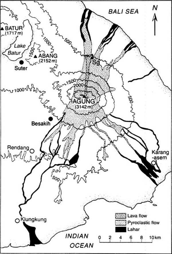 |
Figure 1. Map of Gunung Agung and vicinity, eastern Bali, showing the extent of the 1963 lava flow (cross-hatched), pyroclastic flow deposits (stippled), and lahar deposits (dark shading) of the 1963–1964 eruption (after unpublished map courtesy of Indonesian Volcanological Survey). Sg is Siligading village, where many fatalities occurred. Reproduced from Self and Rampino (2012, figure 3). |
Explosive activity continued intermittently until a second explosive phase of similar intensity occurred two months later, beginning on 16 May 1963 with reported ash plumes reaching 10 km above the 3-km-high summit (figure 2). This phase produced the greatest proportion of the pyroclastic flow material from the eruption and led to additional death and destruction in villages at the foot of the volcano (Self and Rampino, 2012). Explosive outbursts continued intermittently until 17 January 1964. The total death toll of the eruption was estimated between 1,100 and 1,900 (see references in Fontijn et al., 2015). A total estimated volume of erupted magma was ca 0.4 km3 (Self and Rampino, 2012).
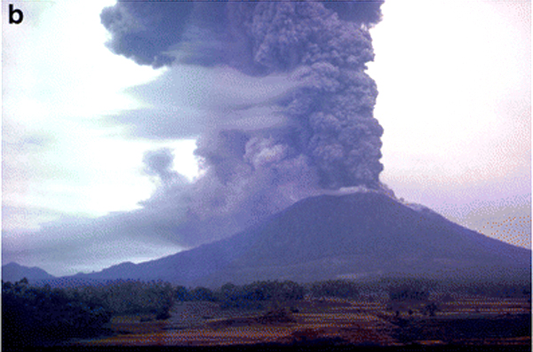 |
Figure 2. Photograph reported to be of the 16 May 1963 eruption column at Agung; the view is from the SW, perhaps near Rendang (shown on figure 1). Photo courtesy of the family of Denis Mathews, reproduced from Self and Rampino (2012, figure 2b). |
Activity between 1964 and 2017. Almost no activity was reported from Agung during 1964-2017. Weak solfataric activity from within the summit crater was reported in 1989 (SEAN 14:07). MODVOLC thermal alerts were reported intermittently on one or two days during a few years (2001, 2002, 2004, 2006, 2008, 2012, 2013), but all of the alerts were located on the middle or lower flanks, suggesting their source was agriculture or forest fires, unrelated to volcanic activity. Chaussard et al. (2013) reported inflation centered on the summit at a rate of 7.8 cm/year between mid-2007 and early 2009, followed by slow deflation at a rate of 1.9 cm/year until mid-2011 (the last acquired data).
Summary of September-December 2017 Activity. Increases in seismic activity were first noted at Agung during mid-August 2017. Exponential increases in the rate of events during the middle of September led PVMBG to incrementally raise the Alert Level from I to IV (lowest to highest) between 14 and 22 September. Steam-and-gas emissions were intermittently observed 50-500 m above the summit crater from the end of September through October, with occasional bursts as high as 1,500 m. Seismicity dropped off almost as quickly as it rose, beginning on 20 October, and then continued a more gradual decrease through the end of the month and into November. The number and intensity of hot spots observed within the summit crater increased during September, then leveled off during October.
Ash emissions first appeared on 21 November, rising to 700 m above the summit. Ash density and heights of plumes increased several times during the rest of November to about 3,000 m. Ashfall as deep as 5 mm affected neighboring communities, and was reported several hundred kilometers from the summit; the international airport about 60 km SW was forced to close for a few days at the end of the month. Thermal data indicated effusion of lava into the summit crater at the end of November. After 30 November, emissions continued, primarily comprised of steam and gas, with intermittent plumes of dense ash, rising up to 2.5 km above the summit throughout December.
Activity during August-September 2017. In their monthly report of volcanic activity for August 2017, PVMBG noted that 49 volcanoes, including Agung, were listed at Alert Level 1, meaning "Normal", with no apparent increases in visual or seismic activity. The first signs of renewed unrest at Agung appeared as an increase in the rate of deep volcanic earthquakes (VA or Vulkanik Dalam) beginning on 10 August 2017. Shallow volcanic earthquakes (VB or Vulkanik Dangkal) began to increase two weeks later on 24 August, followed by an increase in the number of local tectonic earthquakes on 26 August (figure 3). Based on this increased seismicity, and an observation on 13 September of new solfataric activity at the bottom of the summit crater, PVMBG raised the Alert Level the following day from Level I (Normal) to Level II (Beware); the Aviation Color Code was raised to Yellow on a four-color scale (Green, Yellow, Orange, Red). The deeper earthquakes (VA) had a seismic amplitude range from 3-10 mm. The shallow earthquakes (VB) had an amplitude range of 2-7 mm. Otherwise, there was no surface expression of activity during September.
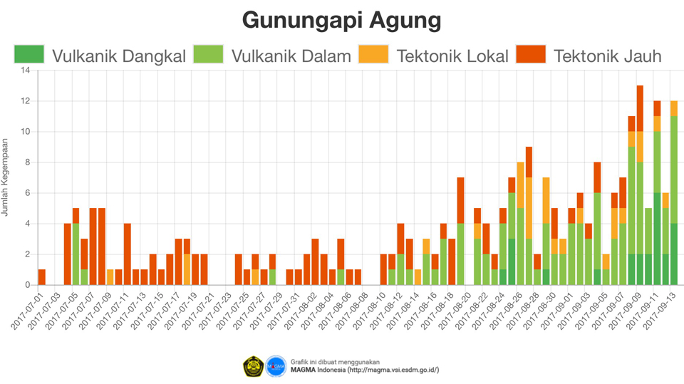 |
Figure 3. Seismic activity at Agung between 1 July and 13 September 2017. The Y-axis is the number of daily earthquakes. The increase in deep volcanic seismicity (VA, or Vulkanik Dalam) that began on 10 August 2017 was followed two weeks later by an increase in shallow volcanic seismicity (Vulkanik Dangkal or VB). Courtesy of PVMBG (Peningkatan Tingkat Aktivitas Gunung Agung, 14 September 2017). |
The Agung Volcano Observatory (AVO) is located in Rendang village about 8 km SW. Webcams are located in Rendang and in Bukit Asah, about 8 km W. On 15 September 2017 a steam emission was observed rising 50 m above the crater rim. The AVO issued a VONA on 18 September noting a rapid increase in volcanic earthquake activity with a small hot spot detected in satellite data. This contributed to them raising the Alert Level again to Level III (Standby), resulting in a 6-km-radius exclusion zone activated around the summit, extending to 7.5 km on the N, SE, and SSW flanks where the pyroclastic flows of 1963 had caused the most damage. Many of the 50,000 village residents within the 6 km exclusion zone began voluntary evacuations. The communities affected included Jungutan (7 km S) and Buana Giri (12 km SE) villages in the Bebandem District, Sebudi Village (6 km SW) in the Selat Subdistrict, Besakih Village (12 km SW) in the Rendang Subdistrict, and Dukuh (4 km NE) and Ban (7.5 km NW) villages in the Kubu Subdistrict. About 9,500 people had voluntarily evacuated from the villages by 22 September 2017.
The observatory issued another VONA on 19 September 2017, reporting an 'ash cloud' at 0255 UTC (1055 Central Indonesia Time, or WITA). It was described as a dense, white plume moving to the W. Around the same time (0240 UTC) MODVOLC recorded ten thermal alerts on the N and E flanks. Bali's Regional Disaster Management Agency (BPBD) reported in Antara News on 19 September that the source of the smoke and ash were forest fires caused by excessively dry conditions.
A VONA issued by AVO in the morning of 22 September stated that a steam emission about 50 m above the summit drifted NW. During the evening of 22 September, PVMBG raised the Alert Level to Level IV (Caution), the highest of the four-level scale, based primarily on continuing increases in seismicity. They expanded the exclusion zone to 9 km around the summit, and to 12 km in the areas S, SE, and NNE. The number of evacuees had risen to nearly 35,000 people by 24 September. Steam-and-gas plumes were intermittently observed rising to 200 m above the crater rim during the rest of September. By 26 September, PVMBG reported increasing seismic activity with 579 deep volcanic (VA) quakes, 373 shallow quakes (VB), and 50 local tectonic events that day. Seismicity continued to escalate through the end of the month. By the end of September, the government was assisting with the logistics of evacuating tens of thousands of livestock, primarily cattle, as well as over 90,000 people from within and around the 9 km exclusion zone. MAGMA Indonesia reported that new steaming and thermal areas within the summit crater expanded during the last week of the month.
Activity during October 2017. Narrow steam plumes rose 50-200 m above the summit crater during the first half of October. The rate of earthquakes during the last week of September and the first week of October continued to fluctuate at high levels, averaging 1-3 per minute, and more than 600 per day. By the first week of October, shallow earthquakes alone had increased to more than 200 per day, suggesting the possibility of magmatic activity at shallow depth. Satellite data showed increasing steam emissions along the NE edge of the crater rim. Tiltmeter data showed sudden deflation on 1 October, followed by continued inflation through 5 October. AVO released a VONA on 7 October noting a steam plume rising 1,500 m above the summit crater at 1245 UTC and drifting E (figure 4).
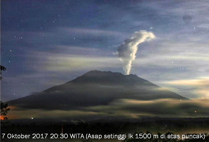 |
Figure 4. A steam plume rose 1,500 m above the summit of Agung on 7 October 2017. Courtesy of PVMBG (Penurunan Status Gunungapi Agung, Bali Dari Level IV (awas) Ke Level III (siaga) Tanggal 29 Oktober 2017 Pukul 16.00 WITA). |
During the second half of the month, steam plumes were denser and rose more frequently to 200-500 m above the summit crater. BNPB flew drones over the summit on 20 and 29 October 2017 and captured 400 aerial photographs (figures 5 and 6). The images revealed a widening of the fracture zone on the E side of the summit crater, and a new fracture on the SE side.
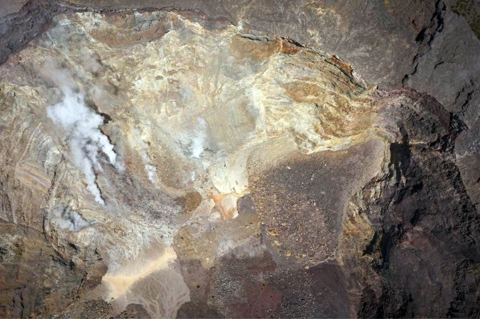 |
Figure 5. A view into the summit crater of Agung on 20 October 2017, taken by a BNPB drone. Steam fumaroles rose from the NNE flank. N is to the left. Courtesy of PVMBG (Penurunan Status Gunungapi Agung, Bali Dari Level IV (awas) Ke Level III (siaga) Tanggal 29 Oktober 2017 Pukul 16.00 WITA). |
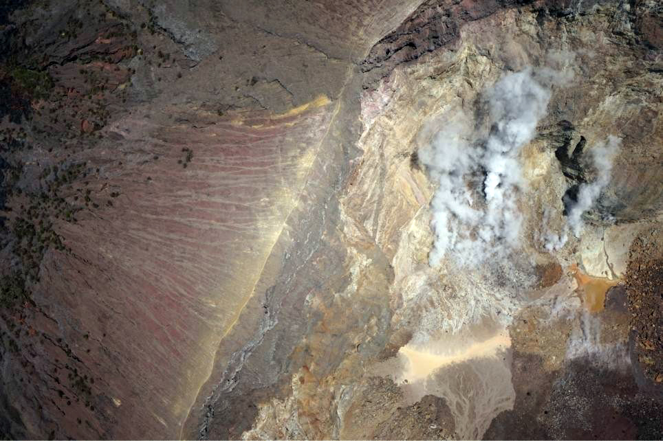 |
Figure 6. A view into the summit crater of Agung on 29 October 2017, taken by a BNPB drone. The steam plumes rose from the NE corner of the summit crater. The NE rim of the crater slopes away to the upper left. Courtesy of PVMBG (Penurunan Status Gunungapi Agung, Bali Dari Level IV (awas) Ke Level III (siaga) Tanggal 29 Oktober 2017 Pukul 16.00 WITA). |
PVMBG noted a decline in seismicity beginning on 20 October 2017 which continued through the end of the month (figure 7), leading them to lower the Alert Level from IV to III on 29 October, and reduce the exclusion zone to a 6 km radius, plus a 7.5 km area in the NNE, SE and SSW sectors. In their late October report, they observed that remote sensing thermal infrared data had detected an increase in the thermal energy beginning on 10 July 2017, in the form of an increased number of hot spots within the summit crater. During August and September, the number of hot spots had increased significantly and correlated with the increases in seismicity (figure 8). The intensity of the thermal anomalies then decreased during October. Inflation resumed in mid-August and peaked in mid-September. After that, the GPS data indicated deflation at lower levels, but uplift of 6 cm occurred near the summit. The deformation rate slowed after 20 October.
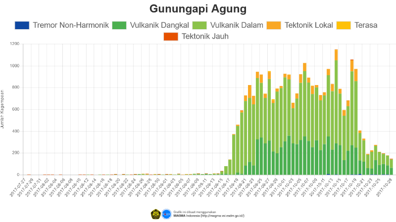 |
Figure 7. Daily seismic activity at Agung from 27 July-29 October 2017. Seismicity decreased noticeably on 20 October 2017, leading PVMBG to lower the Alert Level from IV to III on 29 October. Note that the vertical axis counting the number of daily seismic events ranges from 0 to 1,200, while in figure 3 the same axis ranges from 0 to 14. Courtesy of MAGMA Indonesia (Penurunan Status Gunungapi Agung, Bali dari Level IV (AWAS) ke Level III (SIAGA) Tanggal 29 Oktober 2017 pukul 16.00 WITA). |
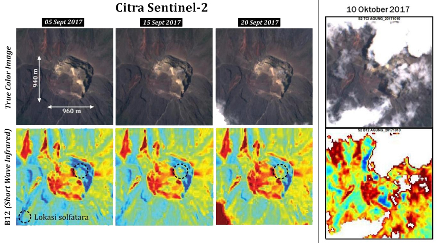 |
Figure 8. Satellite thermal imagery from Citra-Sentinel 2 revealed an increase in the number and intensity of hotspots within the summit caldera of Agung during September 2017, followed by a decrease in early October. Courtesy of PVMBG (Penurunan Status Gunungapi Agung, Bali Dari Level IV (awas) Ke Level III (siaga) Tanggal 29 Oktober 2017 Pukul 16.00 WITA). |
Activity during November 2017. For the first three weeks of November, dense white steam plumes rose 50-500 m above the summit crater. A VONA issued late on 11 November reported a 500-m-high steam plume. Seismicity continued at a much lower rate than during late September-October, with tens of daily events as opposed to hundreds.
The first ash emission of the current eruption occurred on 21 November at 1705 local time; the plume rose to 700 m and drifted ESE (figure 9). Trace amounts of ashfall were reported in the Pidpid-Nawehkerti area about 9 km SE. At the time of the first ash emission, BNPB reported the number of evacuees living in temporary housing at about 25,000. The emission was preceded by a low-frequency tremor. Multiple volcanic ash advisories were issued by the Darwin VAAC on 21 November, although the ash was not visible in satellite imagery due to weather clouds. Continuous tremor with 2-5 mm amplitude was recorded the following three days, and ash-and-steam emissions rose 300-800 m above the summit crater.
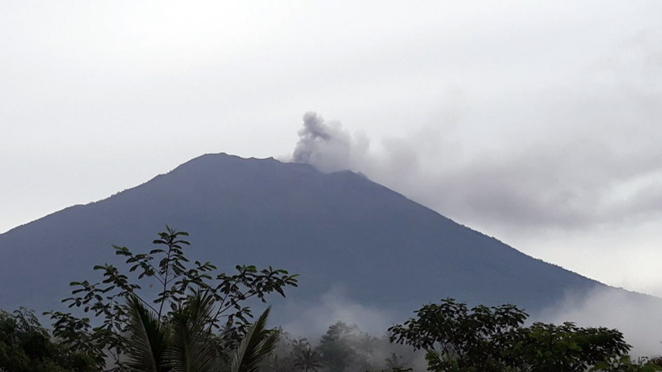 |
Figure 9. The first reported ash emission from Agung in 53 years rose 700 m and drifted SE on 21 November 2017. Courtesy of PVMBG (Letusan Gunung Agung Selasa, 21 November 2017 Pukul 17.05 WITA). |
A larger emission on 25 November sent black-gray ash plumes 2,000 m above the crater rim (figure 10) which then drifted W. The Darwin VAAC reported an ash plume visible in satellite imagery at 7.6 km altitude drifting WSW. Emissions continued later in the day, rising 4.6-6.7 km altitude and extending SE. Bright incandescence at the summit crater was observed that night. Ashfall was reported to the WSW in the villages of Menanga and Rendang (12 km SW) at the AVO Post, and also in Besakih Village, located in the upper part of Pempatan (8 km W). A number of international flights were cancelled from the I Gusti Ngurah Rai International Airport in Denpasar (60 km SW), affecting about 2,000 passengers, although the airport remained open.
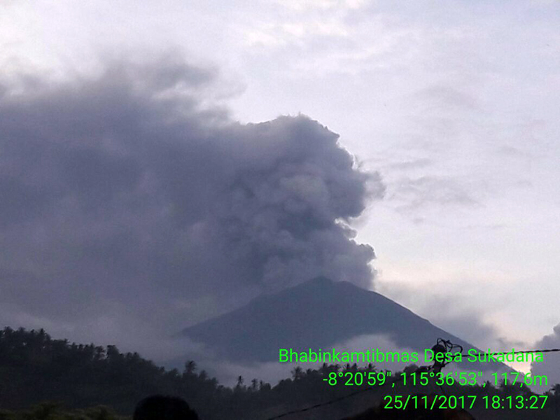 |
Figure 10. An ash emission rose at least 1,500 m above the summit of Agung on 25 November 2017 and drifted W. Courtesy of PVMBG (Letusan Gunung Agung 25 November 2017 Pukul 17:30 Wita). |
Around 0545 local time the following day (26 November), the intensity of the ash emissions increased; the top of the plume reached 3,300 m above the summit at 1100 local time, and was drifting SE and E (figure 11). Ashfall was reported in many areas downwind including North Duda (9 km S), Duda Timur (12 km S), Pempetan, Besakih, Sideman (15 km SSW), Tirta Abang, Sebudi (6 km SW), Amerta Bhuana (10 km SSW), and some villages in Gianyar (20 km WSW) (figure 12). The largest amount, deposits 5 mm thick, was reported in Sibetan (11 km SSE). Trace amounts of ash were also reported much farther away, in Nusa Penida (an island 40 km S), Lombok (100 km ESE), and Sumbawa, 250 km E on the island of West Nusa Tenggara. Explosions from the crater were audible 12.5 km away that evening. Incandescence at the summit was observed from Bukit Asah and Batulompeh. The Darwin VAAC reported continuous ash emissions to 7.9 km altitude drifting SE throughout most the day, increasing to 9.1 km later in the day; ashfall was also reported at the international airport.
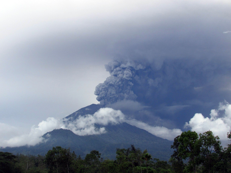 |
Figure 11. A dense plume of ash rose 3,000 m above the summit of Agung and drifted ESE on 26 November 2017. Courtesy of PVMBG (Peningkatan Status Gunungapi Agung, Bali Dari Level III (siaga) Ke Level IV (awas), 27 November 2017). |
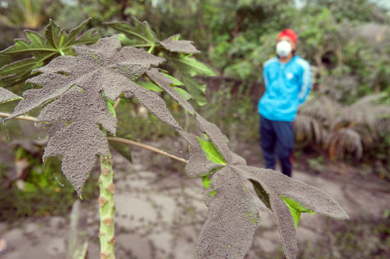 |
Figure 12. Ash from an eruption of Agung on 26 November 2017 covered garden plants in Jungutan Village, 7 km SE. Courtesy of Reuters. |
The airport in Denpasar was forced to close during 27-29 November 2017. On those days ash drifted in multiple directions at different altitudes; it was observed drifting E at 9.1 km altitude, SW at 7.6 km altitude, and was moving S below 6.1 km. This increase in emissions led PVMBG to raise the Alert Level from III to IV on 27 November. Pictures and video showed a white steam plume adjacent to a gray ash plume rising from the crater, suggesting two distinct sources (figure 13).
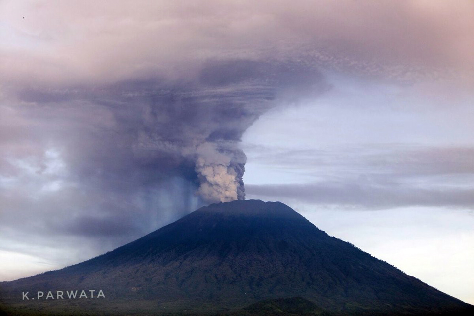 |
Figure 13. A white steam plume and dense gray ash both rose from the summit of Agung on 27 November 2017. Photo by K. Parwata, courtesy of Sutopo Purwo Nugroho, Twitter. |
A single MODVOLC thermal alert appeared at the summit that day, along with a strong thermal anomaly in the MIROVA system data (figure 14) consistent with the appearance of new lava in the summit crater. The tiltmeter installed at the Yehkori station 4 km S of the summit showed continued inflation of up to 6 microradians between 22 and 27 November (figure 15). PVMBG also increased the exclusion zone to a radius of 8 km from the summit crater plus areas 10 km from the summit to the NNE, SE, S, and SW.
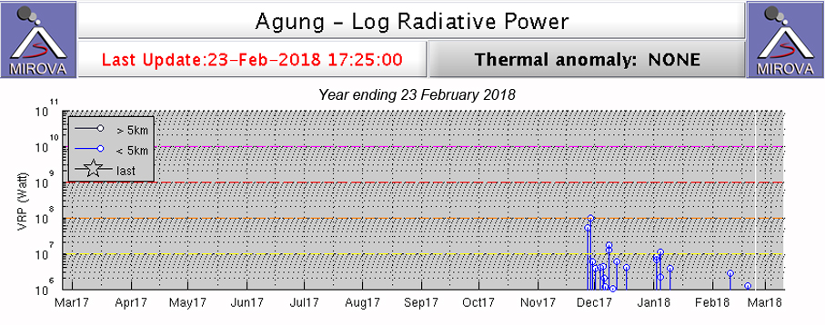 |
Figure 14. A MIROVA plot of satellite infrared data for the year ending 23 February 2018 showed the first thermal anomaly from Agung in late November 2017, consistent with the emergence of lava in the summit crater. Courtesy of MIROVA. |
 |
Figure 15. A steady inflation was measured by the tiltmeter located at the Yehkori station 4 km S of the summit of Agung between 22 November and 27 November. Courtesy of PVMBG (Peningkatan Status Gunungapi Agung, Bali Dari Level III (siaga) Ke Level IV (awas), 27 November 2017). |
MAGMA Indonesia reported that beginning with the ash eruption on 21 November, lahars appeared in the Tukad Yehsa, Tukad Sabuh, and Tukad Beliaung drainages on the S flank, as well as Tukad Bara on the N flank. As of the end of November 2017, these lahars had impacted houses, roads, and agricultural areas. Although ash emissions increased, and lava was confirmed within the summit crater during the last week of November, the number of seismic events remained well below the values recorded during September and October (figure 16).
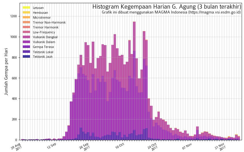 |
Figure 16. Seismicity at Agung decreased significantly beginning on 20 October 2017 and remained well below 200 daily events throughout November, even though ash emissions began on 21 November. Courtesy of PVMBG (Peningkatan Status Gunungapi Agung, Bali Dari Level III (siaga) Ke Level IV (awas), 27 November 2017). |
Ash emissions were reported by PVMBG rising to 3,000 m above the summit and drifting S on 27 November (figure 17). Continuing ash emission during 28-29 November rose to 2,000-4,000 m above the summit and drifted WSW (figure 18). Continuous seismic tremors were recorded during 28 November-1 December.
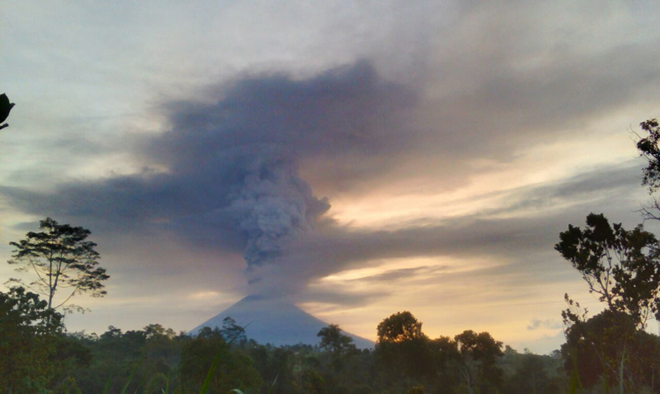 |
Figure 17. Ash plumes from Agung rose to altitudes of around 6,000 m (3,000 m above the summit crater) and drifted S on 27 November 2017. Image courtesy of MAGMA Indonesia (Peningkatan Status Gunungapi Agung, Bali Dari Level Ill (SIAGA) ke Level IV (AWAS), 27 November 2017 10:07 WIB, Ir. Kasbani, M.Sc.). |
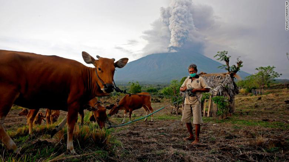 |
Figure 18. A dense plume of steam and ash rose from Agung and drifted away from this villager and his livestock on 28 November 2017. Courtesy of CNN. |
With the increase in ash emissions during the last days of November 2017, satellite instruments also recorded significant releases of SO2 (figure 19). MAGMA Indonesia reported on 1 December that satellite data also recorded high temperatures consistent with new lava within the crater on 27, 28, and 29 November 2017. They estimated the volume of lava in the crater to be about 20 million cubic meters, equivalent to about a third of the total crater volume. The base of the ash-and-steam plumes was often reddish during 29 November-5 December reflecting incandescence from the lava in the crater (figure 20).
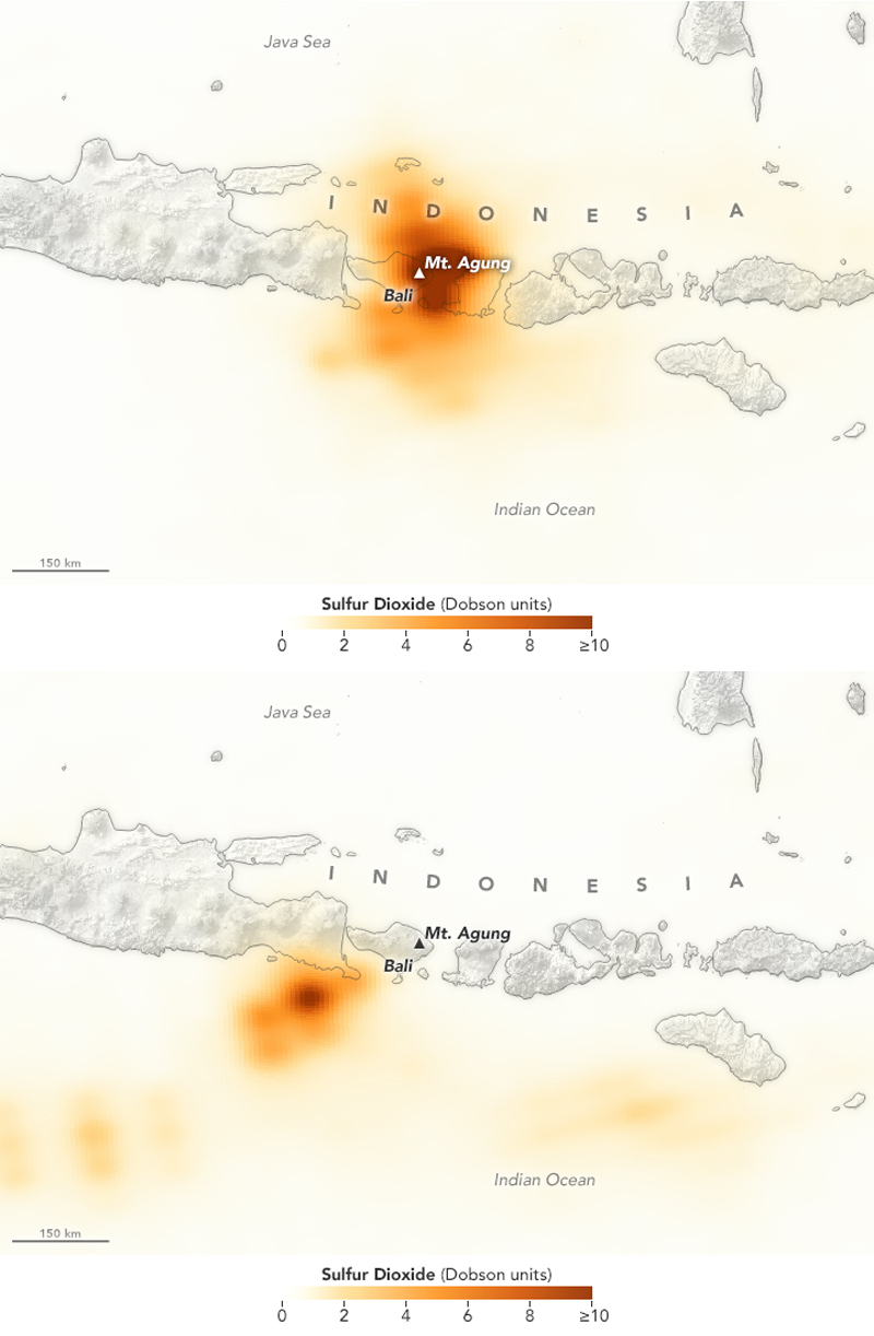 |
Figure 19. The concentrations of SO2 emitting from Agung increased to levels that were easily detected by the Ozone Mapper Profiler Suite (OMPS) on the Suomi National Polar-orbiting Partnership (Suomi-NPP) satellite on 27 (top) and 28 (bottom) November 2017. The concentration of SO2 is measured in Dobson Units, a measure of the molecular density of the SO2 in the atmosphere. These NASA Earth Observatory images were created by Joshua Stevens, using OMPS data from the Goddard Earth Sciences Data and Information Services Center (GES DISC). |
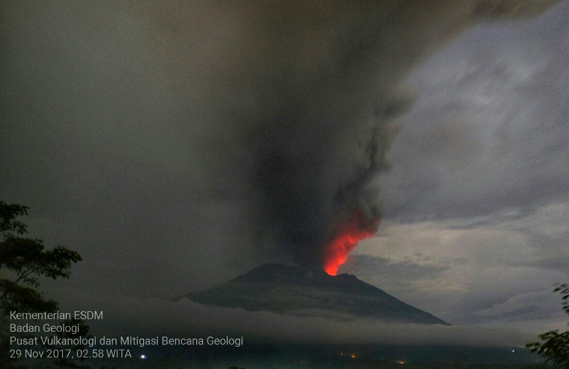 |
Figure 20. Incandescence appeared at the base of the ash-and-steam plume at Agung on 29 November 2017, consistent with lava effusion in the summit crater. Courtesy of MAGMA Indonesia (Perkembangan Terkini Aktivitas Gunung Agung (1 Desember 2017 21:00 WITA), 2 December 2017 07:55 WIB, Ir. Kasbani, M.Sc.). |
By 29 November, continuous ash emissions were rising to 6.4 km altitude and drifting from the SW towards the S, becoming diffuse over the Denpasar region (figure 21). The plume was observed moving E at the same elevation on 30 November, lowering to 5.5 km later in the day. Although emissions were primarily steam and gas beginning on 30 November, pilot reports on 1 December indicated ash was still visible SE of Agung, and steam-and-ash emissions were continuing. Steam-only emissions were reported on 2 December rising less than 1,000 m above the summit.
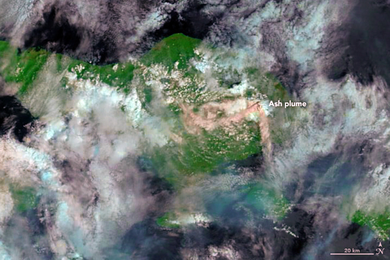 |
Figure 21. Gas-and-ash emissions from Agung on 29 November 2017 were drifting both W and S in this false-color image generated by the Moderate Resolution Imaging Spectroradiometer (MODIS) on NASA's Terra satellite. The image uses a combination of shortwave infrared light and natural color, making it easier to differentiate between ash, clouds, and forest. The plumes appear to rise from two vents in the volcano's summit crater. Courtesy of NASA Earth Observatory. |
Activity during December 2017. Steam, gas, and ash emissions continued throughout December 2017. During the first two weeks, emissions were primarily steam and gas, rising up to 2,000 m (figure 22), and incandescence was often observed at the summit. Dense gray ash emissions were observed, however, during 1-2 December. BNPB noted on 5 December that 63,885 evacuees were distributed in 225 evacuation shelters. On 8 December at 0759 a brief event generated a dense ash plume that rose 2.1 km above the crater rim and drifted W (figure 23). Minor amounts of ash were deposited on the flanks, and lapilli were reported in Temakung. A second ash plume rose 3 km at 1457 later that day.
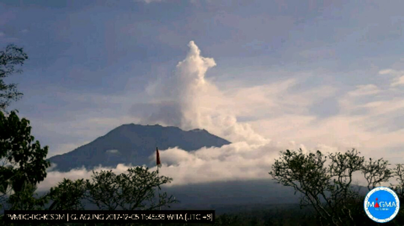 |
Figure 22. A burst of dense steam rose as high as 1,500 m from the crater of Agung on 5 December 2017 at 0848 local time (WITA) and drifted E, after which only a narrow diffuse plume remained. View is from the S. Courtesy of Sutopo Purwo Nugroho, Twitter. |
 |
Figure 23. An eruption at Agung on 8 December 2017 at 0759 WITA sent a dense gray ash plume 2,100 m above peak to the W. View is from the S. Courtesy of Sutopo Purwo Nugroho, Twitter. |
The Darwin VAAC reported multiple daily explosions during 8-15 December, creating ash plumes that drifted NW, W, and WSW at altitudes between 4.3 and 5.5 km. The explosions were visible in the webcams and from ground-based observers, and occasionally in satellite imagery when not blocked by weather clouds. VONA's were issued for events on 8 and 12 December. Multiple events during 11-12 December sent plumes rising up to 2.5 km above the crater rim and drifting NW and W (figure 24).
 |
Figure 24. A small ash emission rose from the crater of Agung during the early morning of 11 December 2017. Courtesy of Sutopo Purwo Nugroho, Twitter. |
The Darwin VAAC reported larger ash emissions to 7.6 km altitude on 15 and 16 December interspersed with lower altitude (5.5-6.1 km) plumes. Continuing, regular discrete emissions during 16-17 December rose to 6.1 km and drifted WNW. An overhead image of the summit crater of 16 December revealed that, since a similar photo was taken on 20 October, new lava had filled about 1/3 of the crater with an estimated 30 million cubic meters of material (figure 25).
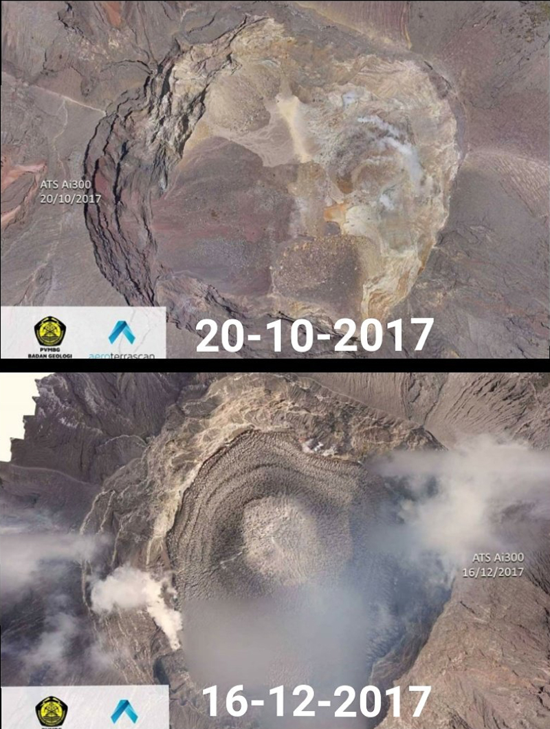 |
Figure 25. Repeated overhead images of the Agung summit crater taken on 20 October and 16 December 2017 showed new lava filling about 1/3 of the crater with an estimated 30 million cubic meters of material. Posted on Twitter by Sutopo Purwo Nugroho for BNBP. |
Discrete emissions to 5.5 km moving N and NNE were common during 18-21 December. Ash and steam drifted both E and W from the summit on 22 December. An ash emission on 23 December rose to 5.8 km and drifted NE, after which repeated emissions continued, rising to 4.6 km (figure 26). Ash fell on the flanks and in Tulamben, Kubu (9 km NE). In the morning of 24 December, a much larger plume drifting W at 10.7 km altitude was visible in satellite imagery. It dissipated after a few hours, and a separate plume was observed drifting NE at 5.5-5.8 km (figure 27); emissions continued throughout the day and into the next. PVMBG reported that the ash deposits from the NE-drifting plume were up to 3 mm thick (figure 28).
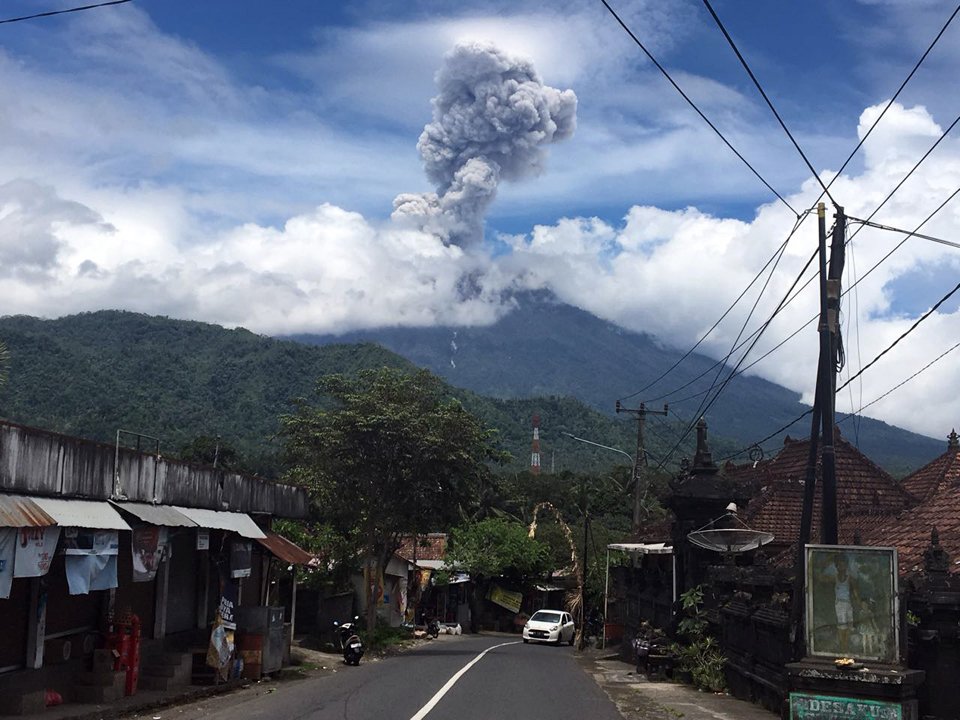 |
Figure 26. An event at Agung on 23 December 2017 sent a dense, gray plume to 2,500 m above the crater rim at 1157 WITA. View is from a village on the W flank, likely about 7 km from the summit. Courtesy of Sutopo Purwo Nugroho, Twitter. |
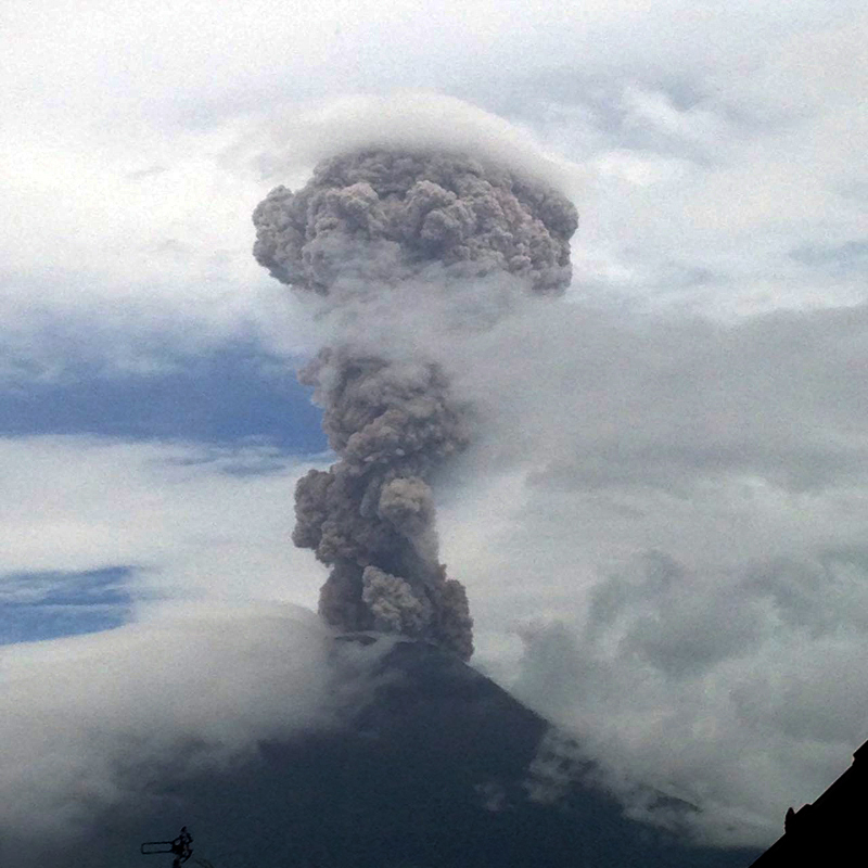 |
Figure 27. Agung erupted steam and ash with a plume height of 2,000-2,500 m on 24 December 2017 at 1005 WITA. Courtesy of Sutopo Purwo Nugroho, Twitter. |
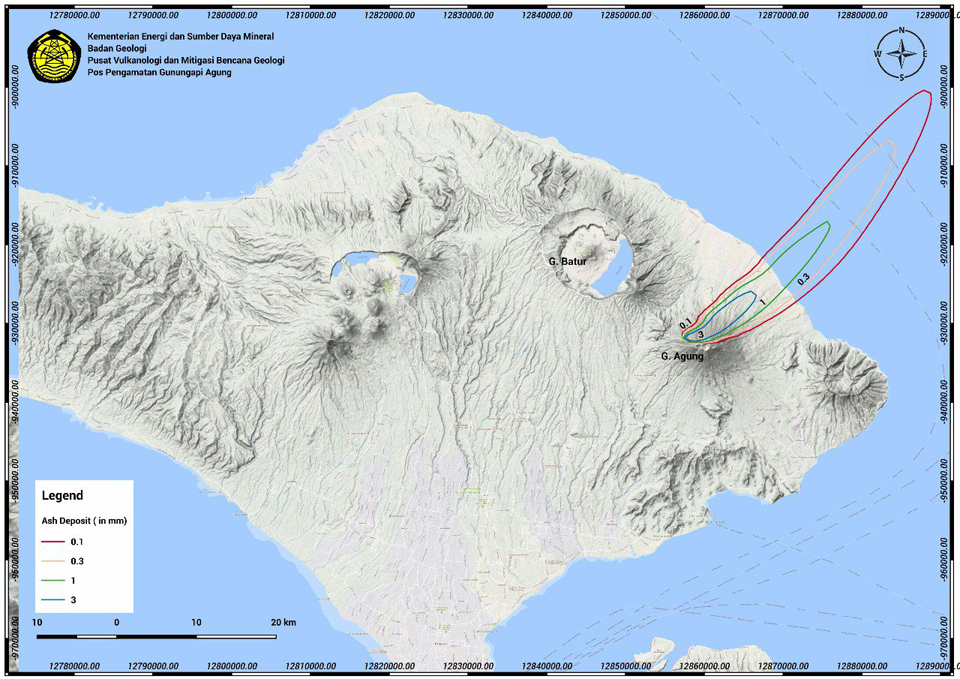 |
Figure 28. Map showing distribution and thickness of volcanic ash and lapilli from the ash emissions at Agung that began on 24 December 2017 at 1005 WITA. A thin layer of ash was deposited in a narrow NE trending band on the NE side of Agung. Courtesy of Sutopo Purwo Nugroho, Twitter. |
As of 25 December, BNPB reported just over 70,000 evacuees spread out in 239 shelters. Discrete ash emissions continued through the end of the month rising as high as 2 km above the crater rim and drifting in several different directions. The last VAAC report of 2017 indicated an ash plume drifting W at 4.3 km altitude on 31 December.
References: Chaussard E, Amelung F, Aoki Y, 2013, Characterization of open and closed volcanic systems in Indonesia and Mexico using InSAR time series. J Geophys Res Solid Earth, 118:3957–3969. DOI: 10.1002/jgrb.50288.
Fontijn K, Costa F, Sutawidjaja I, Newhall C G, Herrin J S, 2015, A 5000-year record of multiple highly explosive mafic eruptions from Gunung Agung (Bali, Indonesia): implications for eruption frequency and volcanic hazards. Bull Volcanol, 77: 59. DOI: 10.1007/s00445-015-0943-x.
Self S, Rampino M, 2012, The 1963–1964 eruption of Agung volcano (Bali, Indonesia). Bull Volcanol 74:1521–1536. DOI: 10.1007/s00445-012-0615-z.
Information Contacts: Pusat Vulkanologi dan Mitigasi Bencana Geologi (PVMBG, also known as Indonesian Center for Volcanology and Geological Hazard Mitigation, CVGHM), Jalan Diponegoro 57, Bandung 40122, Indonesia (URL: http://www.vsi.esdm.go.id/); Badan Nasional Penanggulangan Bencana (BNPB), National Disaster Management Agency, Graha BNPB - Jl. Scout Kav.38, East Jakarta 13120, Indonesia (URL: http://www.bnpb.go.id/); MAGMA Indonesia, Kementerian Energi dan Sumber Daya Mineral (URL: https://magma.vsi.esdm.go.id/); NASA Earth Observatory, EOS Project Science Office, NASA Goddard Space Flight Center, Goddard, Maryland, USA (URL: http://earthobservatory.nasa.gov/); NASA Goddard Space Flight Center (NASA/GSFC), Global Sulfur Dioxide Monitoring Page, Atmospheric Chemistry and Dynamics Laboratory, 8800 Greenbelt Road, Goddard, Maryland, USA (URL: https://so2.gsfc.nasa.gov/); MIROVA (Middle InfraRed Observation of Volcanic Activity), a collaborative project between the Universities of Turin and Florence (Italy) supported by the Centre for Volcanic Risk of the Italian Civil Protection Department (URL: http://www.mirovaweb.it/); Hawai'i Institute of Geophysics and Planetology (HIGP) - MODVOLC Thermal Alerts System, School of Ocean and Earth Science and Technology (SOEST), Univ. of Hawai'i, 2525 Correa Road, Honolulu, HI 96822, USA (URL: http://modis.higp.hawaii.edu/); Antara News (URL: https://bali.antaranews.com); Sutopo Purwo Nugroho, Head of Information Data and Public Relations Center of BNPB via Twitter (URL: https://twitter.com/Sutopo_PN); Cable News Network (CNN), Turner Broadcasting System, Inc. (URL: http://www.cnn.com/); Reuters (URL: http://www.reuters.com/).
Ash explosions and lava dome effusion continue during January-July 2018
After a large, deadly explosive and effusive eruption during 1963-64, Indonesia's Mount Agung was quiet until a new eruption began in November 2017 (BGVN 43:01). A lava dome emerged into the summit crater at the end of November and intermittent plumes of ash rose as high as 3 km above the summit through the end of the year. Activity continued into 2018 with explosions that produced ash plumes rising multiple kilometers above the summit, and the growth of the lava dome within the summit crater. Information about the ongoing eruptive episode comes from Pusat Vulkanologi dan Mitigasi Bencana Geologi (PVMBG), also known as the Indonesian Center for Volcanology and Geological Hazard Mitigation (CVGHM), the Darwin Volcanic Ash Advisory Center (VAAC), and multiple sources of satellite data. This report covers the ongoing eruption from January through July 2018.
Intermittent explosions with ash plumes were reported at Agung several times during January 2018, including Strombolian activity on 19 January. Activity decreased significantly by the end of the month; only one explosion with ash was reported during February. Two ash plumes were reported in March and three were reported each month during April and May. A more substantial explosion in mid-June produced an ash plume that rose to 7 km altitude. A series of deep-seated earthquakes during the third week of June was followed by large explosions and new effusions of lava inside the summit crater beginning on 28 June. A strong thermal signal also appeared on 28 June that gradually diminished during July. Intermittent plumes of steam and ash recurred daily until 19 July; plume heights rose up to 3 km above the summit on several occasions. Strombolian explosions on 2 and 8 July sent ejecta as far as 2 km from the summit. Explosive activity became more intermittent during the last two weeks of the month; the last reported explosion was on 27 July.
Activity during January-May 2018. During most days of January 2018 when fog was not obscuring the summit, PVMGB reported plumes of steam and minor ash rising about 500 m above the summit. In addition, intermittent explosions produced higher, denser ash plumes that rose 1,000-2,500 m above the summit several times. Ash plumes on 1 and 2 January rose to 1,000 and 1,500 m above the summit; incandescence was observed at the summit on both nights, and trace ashfall was reported at the Rendang Post on 2 January. The Darwin VAAC reported the ash plume on 1 January at 6.1 km altitude moving SW. A single MODVOLC thermal alert was recorded on 4 January. On 5 January PVMGB lowered the evacuation radius from 10 to 6 km, permitting the return of thousands of displaced people to their homes. Approximately 17,000 people in seven villages within 6 km of Agung were still under evacuation orders from the events of late 2017.
The Agung Volcano Observatory issued VONA's (Volcano Observatory Notice for Aviation) on 4, 8, 9, 11, 15, 17, 19, 23, 24, and 30 January relating to the larger explosions and ash plumes. On 11 January, an ash plume rose to 2,500 m above the summit and drifted N and NE (figure 29). Another 2,500-m-high ash plume on 19 January was accompanied by Strombolian activity at the summit for several hours, and incandescent ejecta that traveled 1,000 m from the crater. Ashfall was later reported in Tulamben village in the Kubu district (9 km NE) and in Purwekerti village in the Abang district (14 km ENE). Visual monitoring using drones carried out on 22 January showed that the volume of the lava dome was relatively unchanged at around 20 million m3. The summit was obscured by fog for the last week of the month.
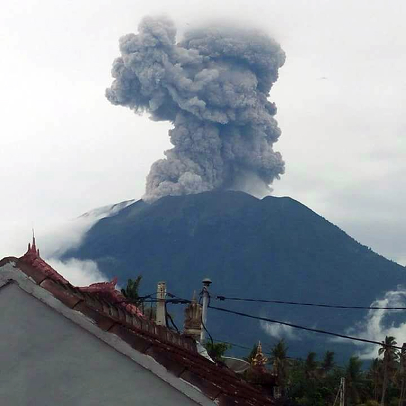 |
Figure 29. An eruption at Agung on 11 January 2018 sent an ash plume to 2,500 m above the summit. Courtesy of MAGMA Indonesia and PVMBG (Erupsi Gunung Agung 11 Januari 2018 17:54 WITA). |
Activity decreased noticeably in late January and February. Steam and minor ash plumes rose only 50-800 m above the summit for most of the month. As a result of the decrease in activity, PVMBG lowered the Alert Level from Level IV to Level III (on a four-level scale) on 10 February 2018. The radius of evacuation was also lowered from 6 to 4 km. A single explosion on 14 February sent an ash plume to 1,500 m above the summit.
For most of March 2018, steam plumes rose less than 400 m above the summit. VONA's were issued by the Agung Volcano Observatory for ash plumes twice, on 12 March (local time) when a plume rose 800 m above the summit and drifted E, and on 26 March when the ash plume rose to 500 m and drifted NW. During much of April 2018, steam plumes rose less than 300 m above the summit; weather obscured views of the summit for most of the last week of the month. AVO issued VONA's for ash plumes on 6, 11 and 30 April; the plumes on 6 and 11 April rose 500 m and drifted W and SW respectively. The Darwin VAAC reported a series of four short-lived explosions with ash plumes on 11 April; they each dissipated within a few hours. PVMBG reported another explosion on 15 April that produced an ash plume that also rose 500 m. The plume on 30 April rose 1,500 m and drifted SW.
Similar activity persisted throughout May 2018. Steam plumes generally rose 50-100 m above the summit crater each day. In addition, explosions were reported on 9, 19, and 29 May. PVMBG reported that no ash plume was observed on 9 May, due to fog obscuring the summit, but the ash plume on 19 May rose to 1,000 m above the summit and drifted SE, and the ash plume on 29 May rose 500 m and drifted SW.
Activity during June and July 2018. The volcano was covered in fog for much of the first two weeks of June. A short-lived explosion on 10 June 2018 was reported by PVMBG, but meteoric clouds obscured the summit. The Darwin VAAC noted the plume in a satellite image drifting W at about 4.6 km altitude. An explosion on 13 June produced an ash plume that rose 2,000 m above the summit and drifted WSW (figure 30). Another explosion was recorded on 15 June, but the summit was obscured, and no ash cloud was visible to ground observers. However, the Darwin VAAC reported the plume visible in satellite imagery at 7 km altitude (about 4 km above the summit) drifting SW and S for most of the day before dissipating. Ashfall was reported about 7 km W in the village of Puregai. PVMBG reported white and gray emissions on 17 June that rose 500 m.
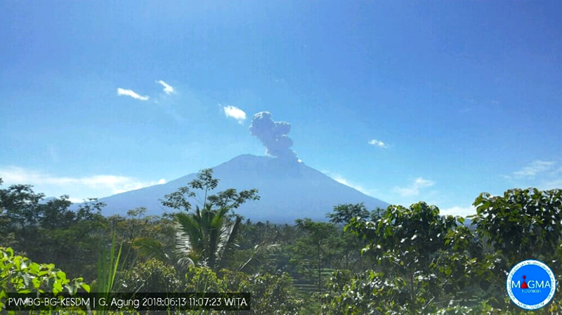 |
Figure 30. An ash plume at Agung on 13 June 2018 rose about 2,000 m above the summit and drifted WSW. View is looking N. Courtesy of PVMBG (Information on G. Agung Eruption, 13 June 2018). |
An explosion during the evening (local time) of 27 June 2018 produced an ash plume that rose 2,000 m from the summit and drifted W. Another explosion the following morning produced a sustained ash cloud that lasted for several hours and again caused ashfall around the village of Puregai. It rose to about 2,000 m above the summit and drifted W and SW (figure 31).
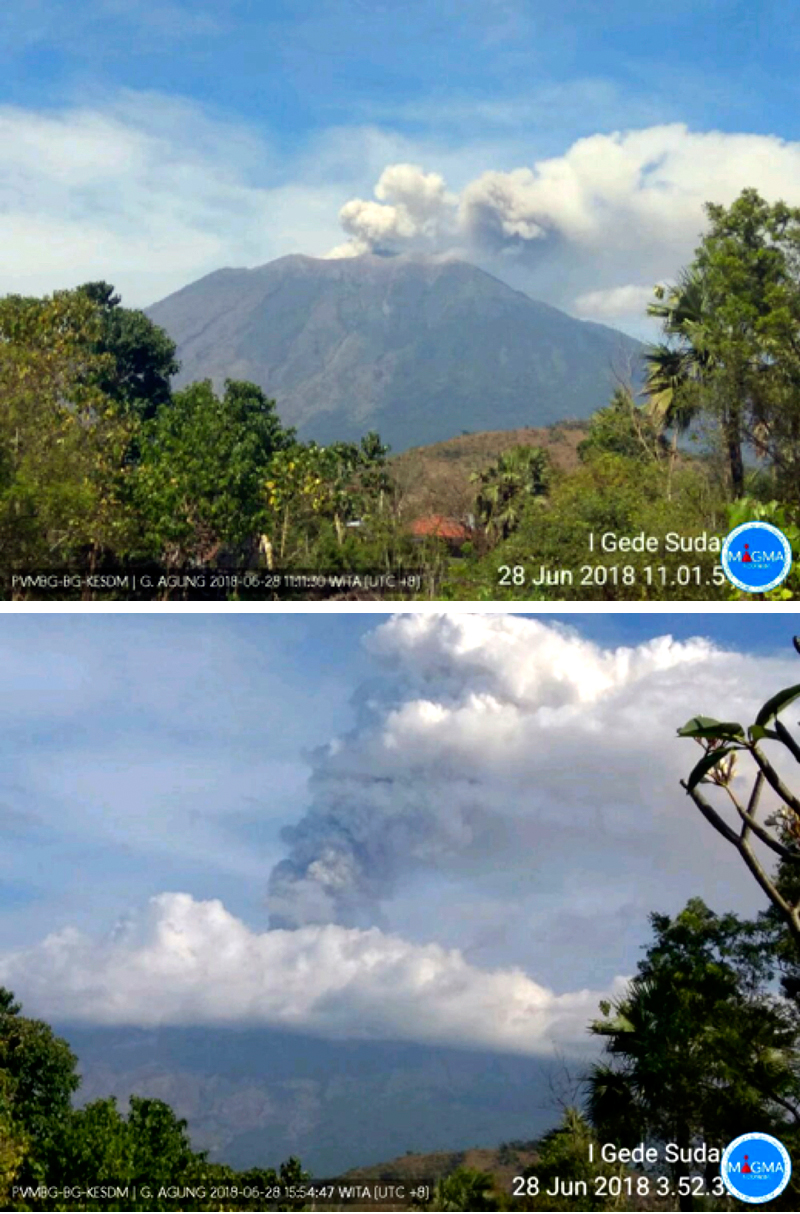 |
Figure 31. A sustained ash eruption began early on 28 June 2018 at Agung (top) and lasted well into the afternoon (bottom). Photo from a PBVBG webcam, posted on Twitter by Sutopo Purwo Nugroho (BNPB). |
PVMBG noted in late June that inflation of 5 mm had occurred since 13 May 2018. They reported that the ash plumes on 28 June caused some airlines to cancel flights to Bali, and ashfall was reported in several villages in Bangli and areas to the W and SW the following day (figure 32). The International Gusti Ngurah Rai (IGNR) airport (60 km SW) in Denpasar, the Blimbing Sari Airport (128 km W) in Banyuwangi, and the Noto Hadinegoro Airport (200 km W) in Jember closed for portions of the day on 29 June (ANTARA News).
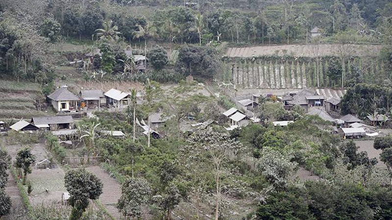 |
Figure 32. Settlement and plantation areas were coated with ash from Mount Agung in Pemuteran Village (10 km W) on 29 June 2018. Courtesy of Tempo.com and ANTARA/Nyoman Budhiana. |
Incandescence overnight on 28-29 June indicated fresh effusions of lava at the summit; they were accompanied by ash emissions that rose 1,500-2,500 m. Thermal satellite images recorded on 29 June indicated significant hotspots within the crater with thermal energy reaching 819 Megawatts; this was the largest amount of thermal energy recorded during the 2017-2018 activity, significantly higher than the maximum recorded of 97 Megawatts reached at the end of November 2017. The MIROVA data clearly reflected the sudden surge of thermal energy into the summit crater at the end of June (figure 33).
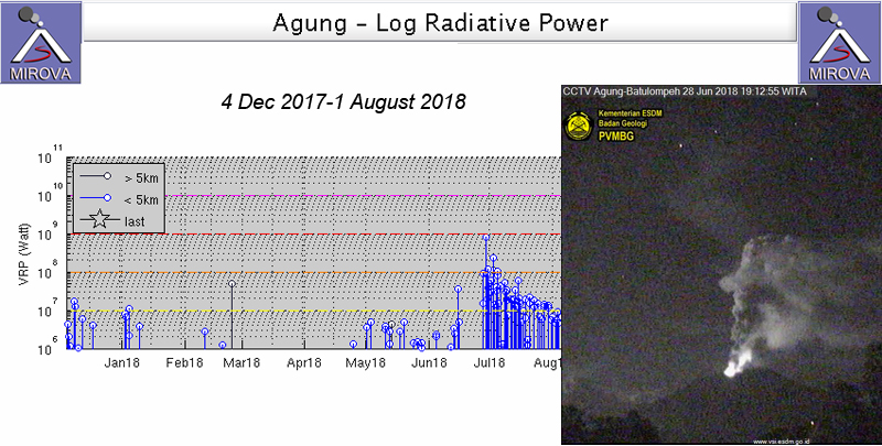 |
Figure 33. A large spike in thermal energy beginning on 28 June 2018 signaled a new surge of lava into the summit crater at Agung. This MIROVA plot of Log Radiative Power showed pulses of activity in early January, May, and early June, followed by the much larger surge of heat in late June that tapered off throughout July. Inset shows the nighttime incandescence on 28 June 2018 that resulted from the new effusion of lava. Photo taken at the PGMBG Webcam in Batu Lompeh (15 km N). Graph courtesy of MIROVA, photo courtesy of PVMBG (Press Release of Mount Agung's Latest Activities, June 29 to 3:00 p.m.) |
The Darwin VAAC reported continuous emissions of ash beginning on 28 June that drifted to the W for over 24 hours. The height was initially reported by ground observers at 3.7 km altitude but was raised to 7 km altitude a few hours later, based on satellite imagery and pilot reports. By late that day, an upper plume (at 7 km) drifted SW and a second plume drifted W at 5.5 km altitude. By late on 29 June the continuous ash plume was drifting NW at 4.9 km altitude; it finally dissipated early on 30 June. In addition to large ash plumes and a major thermal anomaly, a substantial SO2 plume also emerged from Agung on 28-29 June 2018. The plume drifted W over Java and then dispersed to the NW over the next 24 hours (figure 34). A lingering, smaller plume was still visible two days later.
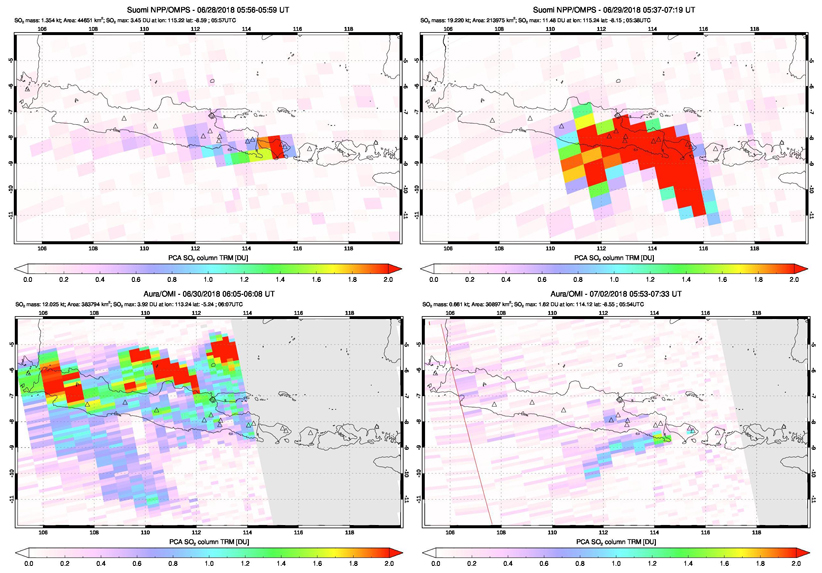 |
Figure 34. A substantial SO2 plume was released from Agung during 28-29 June 2018 and captured by both the OMPS instrument on the Suomi satellite (upper images) and the OMI instrument on the Aura satellite (lower images). The plume first appeared on 28 June (top left) and was much larger the next day (top right). By 30 June it was dissipating over Java to the W and N (bottom left). A smaller plume drifted SW two days later (bottom right). Courtesy of NASA Goddard Space Flight Center. |
A series of discrete eruptions lasting from late on 30 June through 2 July 2018 produced ash plumes that rose from 3.7 to 5.5 km altitude and drifted NW and W, according to the Darwin VAAC. Effusive activity continued to increase during the first week of July 2018 with the continued growth of the lava dome in the summit crater. PVMBG reported an additional volume of lava of 4 million m3 erupted from 28 June through the middle of July bringing the size of the dome to about 27 million m3. The frequency of explosions peaked on 2 July when Strombolian activity sent incandescent ejecta 2 km from the summit in all directions (figure 35).
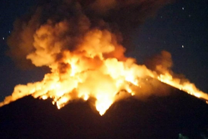 |
Figure 35. The eruption of Mount Agung on 2 July 2017 produced Strombolian activity and incandescent ejecta that traveled 2 km from the summit crater in all directions. Courtesy of ANTARA News/HO/BMKG. |
Several VONA's issued during 2-3 July reported multiple explosions that sent ash plumes 700-2,000 m above the summit. Eighteen explosions were reported by PVMBG between 1 and 8 July. The Darwin VAAC noted a substantial explosion early on 2 July that produced a plume that rose to 7.6 km altitude and drifted W. The remains of the ash plume were discernable in satellite imagery about 250 km W of Agung by the end of the day. The ash plume on 4 July rose 2,500 m above the summit (figure 36).
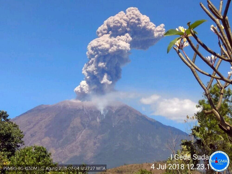 |
Figure 36. An explosion at Agung on 4 July 2018 produced an ash plume that rose 2,500 m above the summit, according to PVMBG. Courtesy of PVMBG (Information on G. Agung Eruption, July 4, 2018). |
Strombolian activity was reported again on 8 July 2018 (figure 37). The Darwin VAAC reported intermittent explosions every day from 3-19 July, with ash plumes rising to altitudes from 3.7 to 6.7 km. Additional explosions were reported on 21, 24, 25, and 27 July (figure 38); ash plumes rose 700-2,000 m and drifted W or SE. MODVOLC thermal alerts resumed on 27 June, and multiple daily alerts persisted on most days through the end of July.
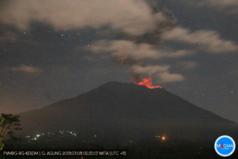 |
Figure 37. Strombolian activity at Agung recurred for the third time in 2018 on 8 July 2018. Courtesy of PVMBG (Agung Strombolian Eruption Today July 8, 2018). |
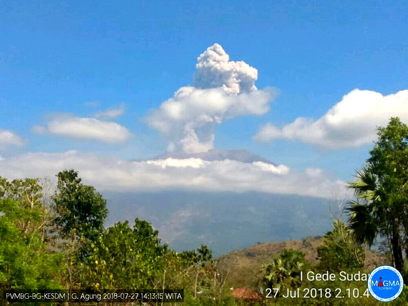 |
Figure 38. A dense ash plume rose about 2,000 m above Mount Agung on 27 July 2018 at 1406 local time. Courtesy of PVMBG (Information on G. Agung Eruption, 27 July 2018). |
Information Contacts: Pusat Vulkanologi dan Mitigasi Bencana Geologi (PVMBG, also known as Indonesian Center for Volcanology and Geological Hazard Mitigation, CVGHM), Jalan Diponegoro 57, Bandung 40122, Indonesia (URL: http://www.vsi.esdm.go.id/); MAGMA Indonesia, Kementerian Energi dan Sumber Daya Mineral (URL: https://magma.vsi.esdm.go.id/); Darwin Volcanic Ash Advisory Centre (VAAC), Bureau of Meteorology, Northern Territory Regional Office, PO Box 40050, Casuarina, NT 0811, Australia (URL: http://www.bom.gov.au/info/vaac/); MIROVA (Middle InfraRed Observation of Volcanic Activity), a collaborative project between the Universities of Turin and Florence (Italy) supported by the Centre for Volcanic Risk of the Italian Civil Protection Department (URL: http://www.mirovaweb.it/); Hawai'i Institute of Geophysics and Planetology (HIGP) - MODVOLC Thermal Alerts System, School of Ocean and Earth Science and Technology (SOEST), Univ. of Hawai'i, 2525 Correa Road, Honolulu, HI 96822, USA (URL: http://modis.higp.hawaii.edu/); NASA Goddard Space Flight Center (NASA/GSFC), Global Sulfur Dioxide Monitoring Page, Atmospheric Chemistry and Dynamics Laboratory, 8800 Greenbelt Road, Goddard, Maryland, USA (URL: https://so2.gsfc.nasa.gov/); Sutopo Purwo Nugroho?, BNPB, Twitter (URL: https://twitter.com/Sutopo_PN); TEMPO.CO, Tempo Building, Jl. Palmerah Barat No. 8, South Jakarta 12210, Indonesia (URL: https://nasional.tempo.co/read/1102118/pvmbg-energi-thermal-erupsi-gunung-agung-kali-ini-paling-besar); ANTARANEWS.com, ANTARA guesthouse lt 19, Jalan Merdeka Selatan No. 17, Jakarta Pusat, Indonesia, (URL: https://en.antaranews.com).
Ongoing intermittent ash plumes and frequent gas-and-steam plumes during August 2018-January 2019
Agung is an active volcano in Bali, Indonesia, that began its current eruptive episode in September 2017. During this time activity has included ash plumes, gas-and-steam plumes, explosions ejecting ballistic blocks onto the flanks, and lava extrusion within the crater.
This report summarizes activity from August 2018 through January 2019 based on information from Pusat Vulkanologi dan Mitigasi Bencana Geologi (PVMBG), also known as the Indonesian Center for Volcanology and Geological Hazard Mitigation (CVGHM), MAGMA Indonesia, the National Board for Disaster Management - Badan Nasional Penanggulangan Bencana (BNPB), the Darwin Volcanic Ash Advisory Center (VAAC), and satellite data.
During August 2018 through January 2019 observed activity was largely gas-and steam plumes up to 700 m above the crater (figures 39 and 40). In late December and January there were several explosions that produced ash plumes up to 5.5 km altitude, and ejected ballistic blocks.
 |
Figure 39. Graph showing the observed white gas-and-steam plumes and gray ash plumes at Agung during August 2018 through January 2019. The dates showing no data points coincided with cloudy days where the summit was not visible. Data courtesy of PVMBG. |
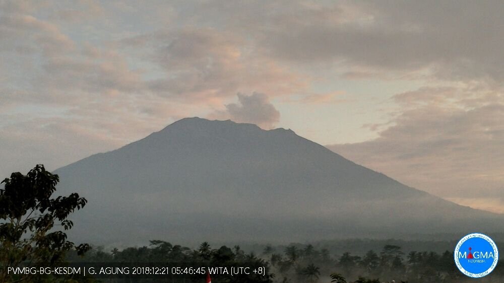 |
Figure 40. A white gas-and-steam plume at Agung on 21 December 2018. Courtesy of MAGMA Indonesia. |
The Darwin VAAC reported an ash plume on 8-9 August based on satellite data, webcam footage, and ground report information. The ash plume rose to 4.3 km and drifted to the W. They also reported a diffuse ash plume to 3.3 km altitude on 16-17 August based on satellite and webcam data. During September through November there were no ash plumes observed at Agung; activity consisted of white gas-and-steam plumes ranging from 10-500 m above the crater.
Throughout December, when observations could be made, activity mostly consisted of white gas-and-steam plumes up to 400 m above the crater. An explosion occurred at 0409 on 30 December that lasted 3 minutes 8 seconds produced an ash plume rose to an altitude of 5.5 km and moved to the SE and associated incandescence was observed at the crater. Light Ashfall was reported in the Karangasem regency to the NE, including Amlapura City and several villages such as in Seraya Barat Village, Seraya Tengah Village, and Tenggalinggah Village (figure 41).
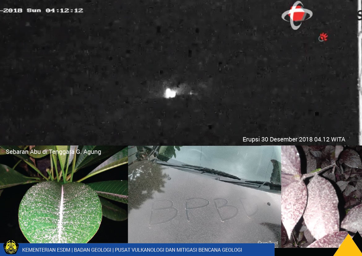 |
Figure 41. A webcam image of an explosion at Agung that began at 0409 on 30 December 2018. Light Ashfall was reported in the Karangasem regency. Courtesy of PVMBG. |
White gas-and-steam plumes continued through January 2019 rising as much as 600 m above the crater. Several Volcano Observatory Notices for Aviation (VONAs) were issued during 18-22 January. An explosion was recorded at 0245 on 19 January that produced an ash plume to 700 m above the crater and ejected incandescent blocks out to 1 km from the crater. On 21 January another ash plume rose to an estimated plume altitude of 5.1 km. The next morning, at 0342 on the 22nd, an ash plume to an altitude of 2 km that dispersed to the E and SE.
Satellite data shows continued low-level thermal activity in the crater throughout this period. MIROVA thermal data showed activity declining after a peak in July, and a further decline in energy in September (figure 42). Low-level thermal activity continued through December. Sentinel-2 thermal data showed elevated temperatures within the ponded lava in the crater (figure 43).
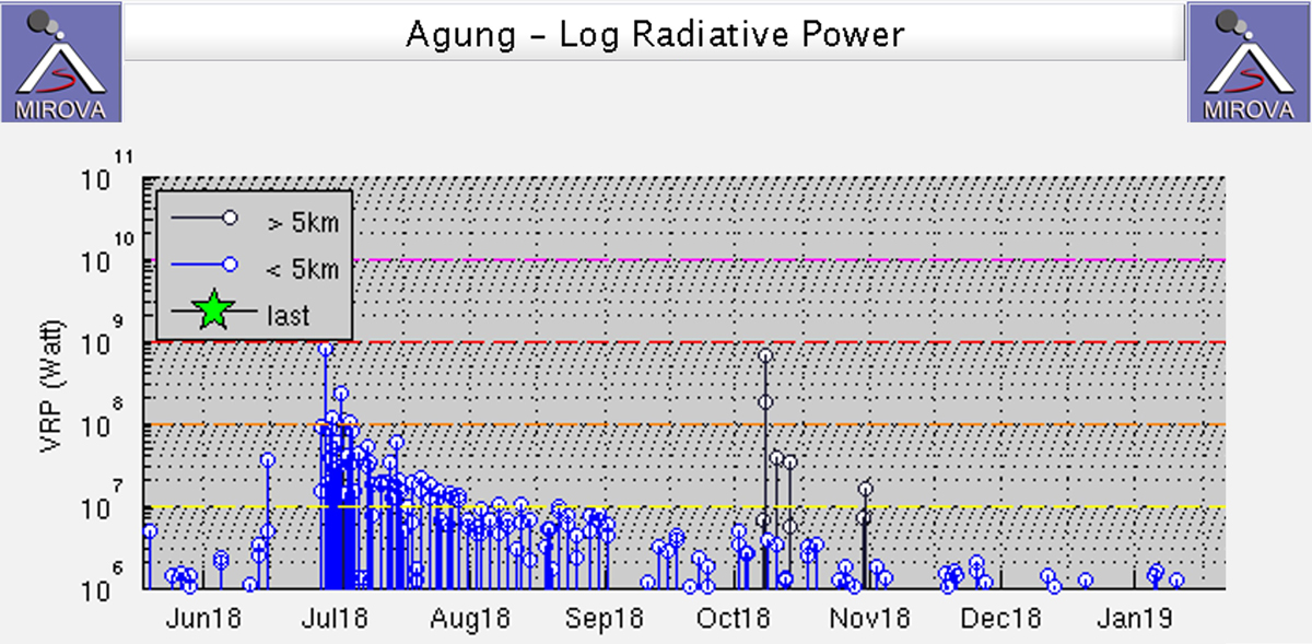 |
Figure 42. Log radiative power MIROVA plot of MODIS infrared data for May 2018 through January 2019 showing thermal anomalies at Agung. The black data lines indicate anomalies more than 10 km from the crater, which are likely due to fires. Courtesy of MIROVA. |
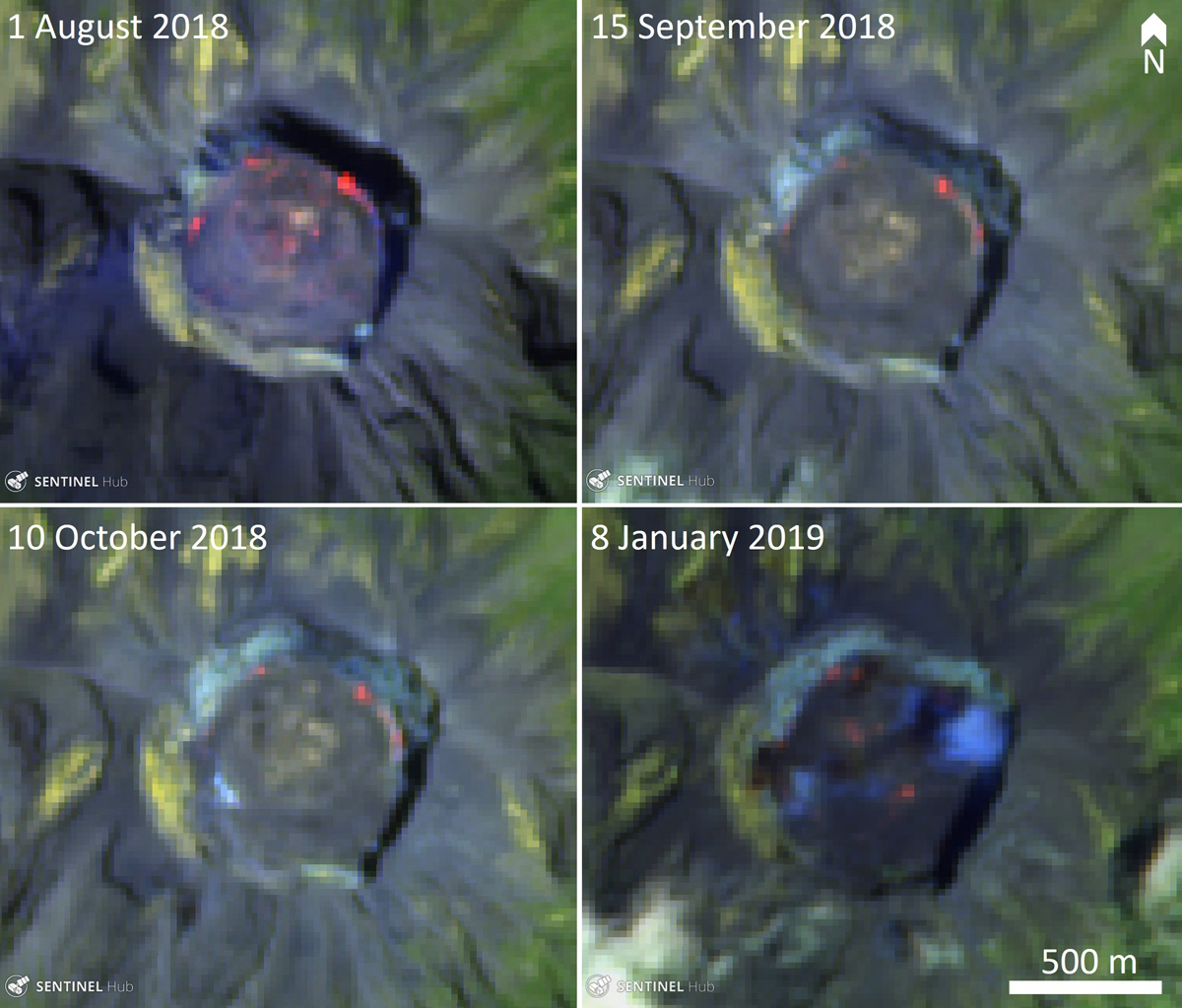 |
Figure 43. Sentinel-2 thermal satellite images showing areas of elevated temperatures within the lava ponded in the Agung crater during August 2018 through January 2019. Courtesy of Sentinel Hub Playground. |
Information Contacts: Pusat Vulkanologi dan Mitigasi Bencana Geologi (PVMBG, also known as Indonesian Center for Volcanology and Geological Hazard Mitigation, CVGHM), Jalan Diponegoro 57, Bandung 40122, Indonesia (URL: http://www.vsi.esdm.go.id/); Badan Nasional Penanggulangan Bencana (BNPB), National Disaster Management Agency, Graha BNPB - Jl. Scout Kav.38, East Jakarta 13120, Indonesia (URL: http://www.bnpb.go.id/); MAGMA Indonesia, Kementerian Energi dan Sumber Daya Mineral (URL: https://magma.vsi.esdm.go.id/); Darwin Volcanic Ash Advisory Centre (VAAC), Bureau of Meteorology, Northern Territory Regional Office, PO Box 40050, Casuarina, NT 0811, Australia (URL: http://www.bom.gov.au/info/vaac/); MIROVA (Middle InfraRed Observation of Volcanic Activity), a collaborative project between the Universities of Turin and Florence (Italy) supported by the Centre for Volcanic Risk of the Italian Civil Protection Department (URL: http://www.mirovaweb.it/); Sentinel Hub Playground (URL: https://www.sentinel-hub.com/explore/sentinel-playground).
Continued explosions with ash plumes and incandescent ejecta, February-May 2019
After a large, deadly explosive and effusive eruption during 1963-64, Indonesia's Mount Agung on Bali remained quiet until a new eruption began in November 2017 (BGVN 43:01). Lava emerged into the summit crater at the end of November and intermittent ash plumes rose as high as 3 km above the summit through the end of the year. Activity continued throughout 2018 with explosions that produced ash plumes rising multiple kilometers above the summit, and the slow effusion of the lava within the summit crater (BGVN 43:08, 44:02). Information about the ongoing eruptive episode comes from Pusat Vulkanologi dan Mitigasi Bencana Geologi (PVMBG), also known as the Indonesian Center for Volcanology and Geological Hazard Mitigation (CVGHM), the Darwin Volcanic Ash Advisory Center (VAAC), and multiple sources of satellite data. This report covers the ongoing eruption from February through May 2019.
Intermittent but increasingly frequent and intense explosions with ash emissions and incandescent ejecta characterized activity at Agung during February through May 2019. During February, explosions were reported three times; events on seven days in March were documented with ash plumes and ashfall in surrounding villages. Five significant events occurred during April; two involved incandescent ejecta that traveled several kilometers from the summit, and ashfall tens of kilometers from the volcano. Most of the five significant events reported in May involved incandescent ejecta and ashfall in adjacent villages; air traffic was disrupted during the 24 May event. Ash plumes in May reached altitudes over 7 km multiple times. Thermal activity increased steadily during the period, according to both the MIROVA project (figure 44) and MODVOLC thermal alert data. MAGMA Indonesia reported at the end of May 2019 that the volume of lava within the summit crater remained at about 25 million m3; satellite information indicated continued thermal activity within the crater. Alert Level III (of four levels) remained in effect throughout the period with a 4 km exclusion radius around the volcano.
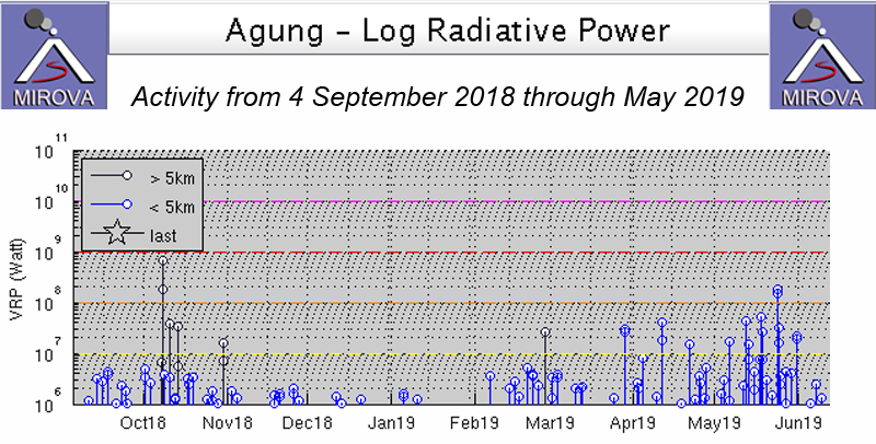 |
Figure 44. Thermal activity at Agung from 4 September 2018 through May 2019 was variable. The increasing frequency and intensity of thermal events was apparent from February-May. Courtesy of MIROVA. |
Steam plumes rose 30-300 m high daily during February 2019. The Agung Volcano Observatory (AVO) and PVMBG issued a VONA on 7 February (UTC) reporting an ash plume, although it was not visible due to meteoric cloud cover. Incandescence, however, was observed at the summit from webcams in both Rendang and Karangasem City (16 km SE). The seismic event associated with the explosion lasted for 97 seconds. A similar event on 13 February was also obscured by clouds but produced a seismic event that lasted for 3 minutes and 40 seconds, and ashfall was reported in the village of Bugbug, about 20 km SE. On 22 February a gray ash plume rose 700 m from the summit during a seismic event that lasted for 6 minutes and 20 seconds (figure 45). The Darwin VAAC reported the plume visible in satellite imagery moving W at 4.3 km altitude. It dissipated after a few hours, but a hotspot remained visible about 10 hours later.
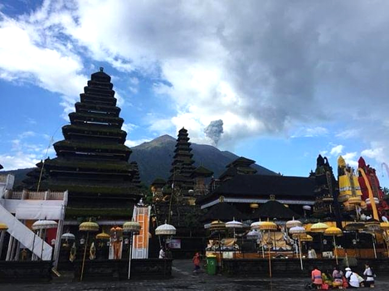 |
Figure 45. An ash plume rose from the summit of Agung on 22 February 2019, viewed from the Besakih temple, 7 km SW of the summit. Courtesy of PunapiBali. |
Persistent steam plumes rose 50-500 m from the summit during March 2019. An explosion on 4 March was recorded for just under three minutes and produced ashfall in Besakih (7 km SW); no ash plume was observed due to fog. A short-lived ash plume rose to 3.7 km altitude and drifted SE on 8 March (UTC) 2019. The seismic event lasted for just under 4 minutes. Ash emissions were reported on 15 and 17 March to 4.3 and 3.7 km altitude, respectively, drifting W (figure 46). Ashfall from the 15 March event spread NNW and was reported in the villages of Kubu (6 km N), Tianyar (14 km NNW), Ban, Kadundung, and Sukadana. MAGMA Indonesia noted that two explosions on the morning of 17 March (local time) produced gray plumes; the first sent a plume to 500 m above the summit drifting E and lasted for about 40 seconds, while the second plume a few hours later rose 600 m above the crater and lasted for 1 minute and 16 seconds. On 18 March an ash plume rose 1 km and drifted W and NW. An event on 20 March was measured only seismically by PVMBG because fog prevented observations. An eruption on 28 March produced an ash plume 2 km high that drifted W and NW. The seismic signal for this event lasted for about two and a half minutes. The Darwin VAAC reported the ash plume at 5.5 km altitude, dissipating quickly to the NW. No ash was visible four hours later, but a thermal anomaly remained at the summit (figure 47). Ashfall was reported in nearby villages.
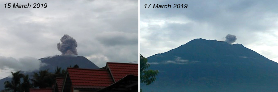 |
Figure 46. Ash plumes from Agung on 15 (left) and 17 (right) March 2019 resulted in ashfall in communities 10-20 km from the volcano. Courtesy of PVMBG and MAGMA Indonesia (Information on G. Agung Eruption, 15 March 2019 and Gunung Agung Eruption Press Release March 17, 2019). |
 |
Figure 47. A thermal anomaly was visible through thick cloud cover at the summit of Agung on 29 March 2019 less than 24 hours after a gray ash plume was reported 2,000 m above the summit. "Atmospheric Penetration" rendering (bands 12, 11, and 8A) courtesy of Sentinel Hub Playground. |
The first explosion of April 2019 occurred on the 3rd (UTC); PVMBG reported the dense gray ash plume 2 km above the summit drifting W. A few hours later the Darwin VAAC raised the altitude to 6.1 km based on infrared temperatures in satellite imagery. The seismic signal lasted for three and a half minutes and the explosion was heard at the PGA Post in Rendang (12 km SW). Incandescent material fell within a radius of 2-3 km, mainly on the S flank (figure 48). Ashfall was reported in the villages of Telungbuana, Badeg, Besakih, Pempatan, Teges, and Puregai on the W and S flanks (figure 49). An explosion on 11 April also produced a dense gray ash plume that rose 2 km above the summit and drifted W. A hotspot remained about six hours later after the ash dissipated.
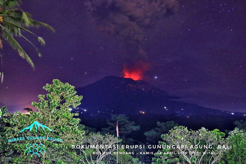 |
Figure 48. Incandescent ejecta appeared on the flanks of Agung after an eruption on 4 April 2019 (local time) as viewed from the observation post in Rendang (8 km SW). Courtesy of Jamie Sincioco. |
 |
Figure 49. Ashfall in a nearby town dusted mustard plants on 4 April 2019 from an explosion at Agung the previous day. Courtesy of Pantau.com (Photo: Antara / Nyoman Hendra). |
PVMBG reported an eruption visible in the webcam early on 21 April (local time) that rose to 5.5 km altitude and drifted SW. The ash spread W and S and ash fell around Besakih (7 km SW), Rendang (8 km SW), Klungkung (25 km S), Gianyar (20 km WSW), Bangli (17 km WNW), Tabanan (50 km WSW), and at the Ngurah Rai-Denpasar Airport (60 km SW). About 15 hours later a new explosion produced a dense gray ash plume that rose to 3 km above the summit and produced incandescent ejecta in all directions as far as 3 km away (figure 50). The ash spread to the S and ashfall was reported in Besakih, Rendang, Sebudi (6 km SW), and Selat (12 km SSW). Both of the explosions were heard in Rendang and Batulompeh. The incandescent ejecta from the explosions remained within the 4-km exclusion zone. A satellite image on 23 April showed multiple thermal anomalies within the summit crater (figure 51). A dense gray plume drifted E from Agung on 29 April (30 April local time) at 4.6 km altitude. It was initially reported by ground observers, but was also visible in multispectral satellite imagery for about six hours before dissipating.
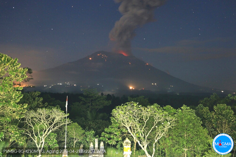 |
Figure 50. An explosion at Agung on 21 April 2019 sent incandescent eject 3,000 m from the summit. Courtesy of MAGMA Indonesia (Gunung Agung Eruption Press Release April 21, 2019). |
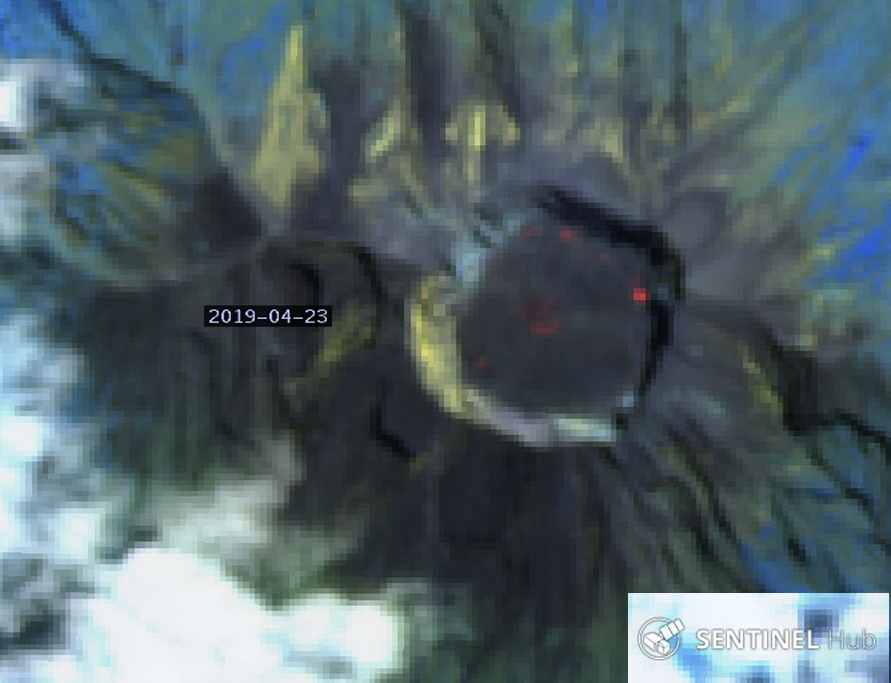 |
Figure 51. Multiple thermal anomalies were still present within the summit crater of Agung on 23 April 2019 after two substantial explosions produced ash and incandescent ejecta around the summit two days earlier. "Atmospheric Penetration" rendering (bands 12, 11, and 8A) courtesy of Sentinel Hub Playground. |
PVMBG reported an eruption on 3 May 2019 that was recorded on a seismogram with a signal that lasted for about a minute. Satellite imagery reported by the Darwin VAAC showed a growing hotspot and possible ash near the summit at 4.3 km altitude moving NE. A few days later, on 6 May, a gray ash plume rose to 5.2 km altitude and drifted slowly W before dissipating; it was accompanied by a seismic signal that lasted for about two minutes. Explosions on 12 and 18 May produced significant amounts of incandescent ejecta (figure 52). The seismic signal for the 12 May event lasted for about two minutes; no plume was observed due to fog, but incandescent ejecta was visible on the flanks and the explosion was heard at Rendang. The Darwin VAAC reported an ash plume from the explosion on 17 May (18 May local time) at 6.1 km altitude in satellite imagery moving E. They revised the altitude a short while later to 7.6 km based on IR temperature and movement; the plume drifted N, NE, and E in light and variable winds. A few hours after that it was moving NE at 7.6 km altitude and SE at 5.5 km altitude; this lasted for about 12 hours until it dissipated. Ashfall was reported in villages downwind including Cutcut, Tongtongan, Bonyoh (20 km WNW), and Temakung.
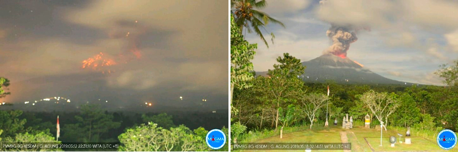 |
Figure 52. Explosions on 12 (left) and 18 (right) May (local time) 2019 produced substantial ejecta on the flanks of Agung visible from a distance of 10 km or more in PVMBG webcams. The ash plume from the 18 May event resulted in ashfall in numerous communities downwind. Courtesy of PVMBG (Information Eruption G. Agung, May 13, 2019, Information Eruption G. Agung, May 18, 2019). |
The initial explosion on 18 May was captured by a webcam at a nearby resort and sent incandescent ejecta hundreds of meters down the NE flank within 20 seconds (figure 53). Satellite imagery on 3, 8, 13, and 18 May indicated multiple thermal anomalies growing stronger at the summit. All of the images were captured within 24 hours of an explosive event reported by PVMBG (figure 54).
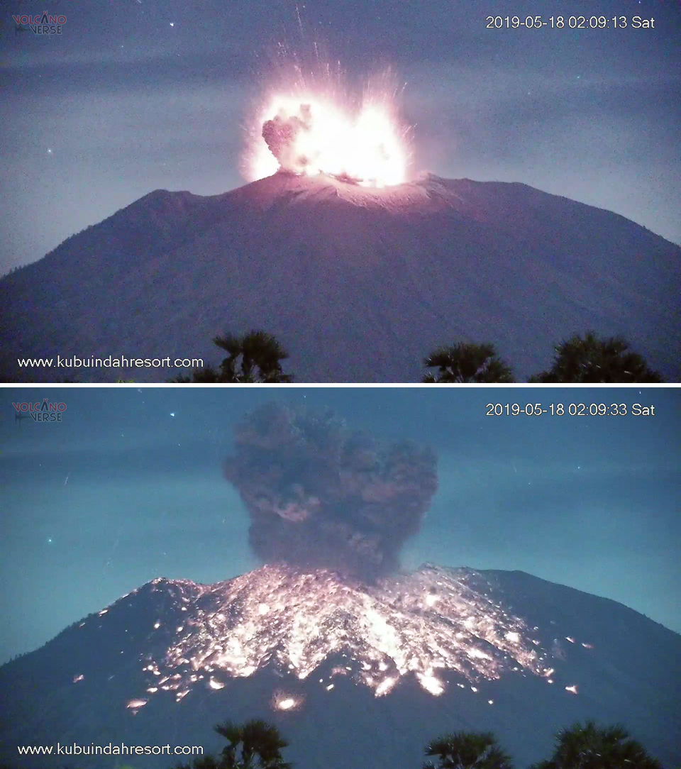 |
Figure 53. The 18 May 2019 explosion at Agung produced an ash plume that rose to over 7 km altitude and large bombs of incandescent material that traveled hundreds of meters down the NE flank within the first 20 seconds of the explosion. Images taken from a private webcam located 12 km NE. Courtesy of Volcanoverse, used with permission. |
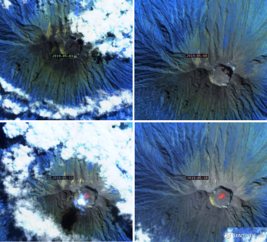 |
Figure 54. Satellite images from 3, 8, 13, and 18 May 2019 at Agung showed persistent and increasing thermal anomalies within the summit crater. All images were captured within 24 hours of explosions reported by PVMBG. "Atmospheric Penetration" rendering (bands 12, 11, and 8A) courtesy of Sentinel Hub Playground. |
PVMBG issued a VONA on 24 May 2019 reporting a new ash emission. They indicated that incandescent fragments were ejected 2.5-3 km in all directions from the summit, and the seismic signal lasted for four and a half minutes (figure 55). A dense gray ash plume was observed from Tulamben on the NE flank rising 2 km above the summit. Satellite imagery indicated that the plume drifted SW and ashfall was reported in the villages of Besakih, Pempatan, Menanga, Sebudi, Muncan, Amerta Bhuana, Nongan, Rendang, and at the Ngurah Rai Airport in Denpassar. Additionally, ashfall was reported in the districts of Tembuku, Bangli, and Susut (20 km SW). The Darwin VAAC reported an ash plume visible in satellite imagery at 4.6 km altitude along with a thermal anomaly and incandescent lava visible in webcam imagery. The remains of the ash plume were about 170 km S of the airport in Denpasar (60 km SW) and had nearly dissipated 18 hours after the event. According to a news article several flights to and from Australia were cancelled or diverted, though the International Gusti Ngurah Rai (IGNR) airport was not closed. On 31 May another large explosion produced the largest ash plume of the report period, rising more than 2 km above the summit (figure 56). The Darwin VAAC reported its altitude as 8.2 km drifting ESE visible in satellite data. It split into two plumes, one drifted E at 8.2 km and the other ESE at 6.1 km altitude, dissipating after about 20 hours.
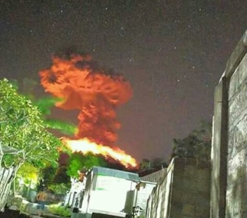 |
Figure 55. A large explosion at Agung on 24 May 2019 produced incandescent ejecta that covered all the flanks and dispersed ash to many communities to the SW. Courtesy of PVMBG (Gunung Agung Eruption Press Release 24 May 2019 20:38 WIB, Kasbani, Ir., M.Sc.). |
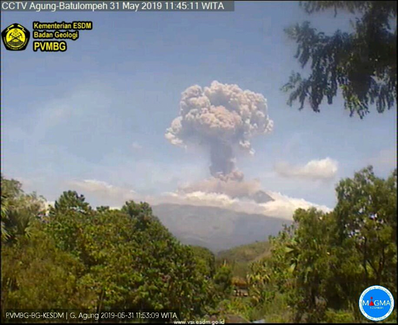 |
Figure 56. An explosion at Agung on 31 May 2019 sent an ash plume to 8.2 km altitude, the highest for the report period. Courtesy of Sutopo Purwo Nugroho, BNPB. |
Information Contacts: Pusat Vulkanologi dan Mitigasi Bencana Geologi (PVMBG, also known as Indonesian Center for Volcanology and Geological Hazard Mitigation, CVGHM), Jalan Diponegoro 57, Bandung 40122, Indonesia (URL: http://www.vsi.esdm.go.id/); MAGMA Indonesia, Kementerian Energi dan Sumber Daya Mineral (URL: https://magma.vsi.esdm.go.id/); MIROVA (Middle InfraRed Observation of Volcanic Activity), a collaborative project between the Universities of Turin and Florence (Italy) supported by the Centre for Volcanic Risk of the Italian Civil Protection Department (URL: http://www.mirovaweb.it/); Sentinel Hub Playground (URL: https://www.sentinel-hub.com/explore/sentinel-playground); The Jakarta Post, Mount Agung eruption disrupts Australian flights, (URL: https://www.thejakartapost.com/news/2019/05/25/mount-agung-eruption-disrupts-australian-flights.html); PunapiBali (URL: http://punapibali.com/, Twitter: https://twitter.com/punapibali, image at https://twitter.com/punapibali/status/1098869352588288000/photo/1); Jamie S. Sincioco, Phillipines (Twitter @jaimessincioco, Image at https://twitter.com/jaimessincioco/status/1113765842557104130/photo/1); Pantau.com (URL: https://www.pantau.com/berita/erupsi-gunung-agung-sebagian-wilayah-bali-terpapar-hujan-abu?utm_source=dlvr.it&utm_medium=twitter); Volcanoverse (URL: https://www.youtube.com/channel/UCi3T_esus8Sr9I-3W5teVQQ); Sutopo Purwo Nugroho, BNPB (Twitter: @Sutopo_PN, URL: https://twitter.com/Sutopo_PN ).
Quiet returns after explosions on 10 and 13 June 2019
After a large, deadly explosive and effusive eruption during 1963-64, Indonesia's Mount Agung on Bali remained quiet until a new eruption began in November 2017 (BGVN 43:01). Activity continued throughout 2018 with explosions that produced ash plumes rising multiple kilometers above the summit, and the slow effusion of the lava within the summit crater. Increasingly frequent and intense explosions with ash emissions and incandescent ejecta characterized activity during February through May 2019 (BGVN 44:06). Two more explosions in June 2019 produced significant ash plumes; no further explosive activity occurred through October 2019. Information about Agung comes from Pusat Vulkanologi dan Mitigasi Bencana Geologi (PVMBG), also known as the Indonesian Center for Volcanology and Geological Hazard Mitigation (CVGHM), the Darwin Volcanic Ash Advisory Center (VAAC), and multiple sources of satellite data. This report covers the end of the eruption in June and observations through October 2019.
After a large explosion on 31 May 2019, a smaller event occurred on 10 June. Another large explosion with an ash plume that rose to 9.1 km altitude was recorded on 13 June (local time). It drifted hundreds of kilometers before dissipating. No further explosive activity was reported through October 2019, only diffuse white steam plumes rising at most a few hundred meters above the summit. The Alert Level remained at III (of four levels) throughout the period. The record of thermal activity showed an increase during the explosive events of late May and June, but then decreased significantly (figure 57). There was no obvious thermal signature in satellite images that explained the small increase in thermal energy recorded by the MIROVA data at the end of August 2019.
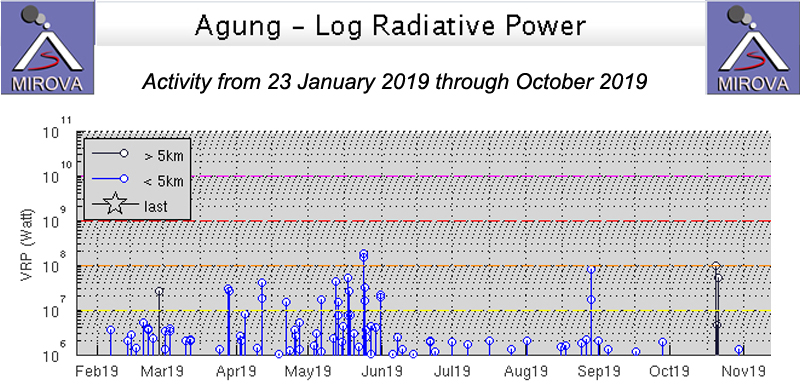 |
Figure 57. The thermal energy at Agung increased significantly during the explosive events of late May and early June 2019, and then decreased substantially as seen in this MIROVA graph from 23 January through October 2019. There was no obvious satellite thermal signature to explain the brief increase in thermal energy in late August. Courtesy of MIROVA. |
On 31 May 2019 a large explosion produced an ash plume that rose more than 2 km above the summit (BGVN 44:06, figure 56). The Darwin VAAC reported that it split into two plumes, one drifted E at 8.2 km and the other ESE at 6.1 km altitude, dissipating after about 20 hours early on 1 June. A small eruption with an ash plume that rose to 3.9 km altitude was reported the next day by the Darwin VAAC. It was detected in the webcam and pilot reports confirmed that it drifted E for a few hours before dissipating. PVMBG reported gray emissions to 300 m above the peak on 1 June and 100 m above the summit on 2 June. By 6 June the emissions were white, rising only 50 m above the summit. For several subsequent days, the summit was covered in fog with no observations of emissions.
On 10 June 2019 an explosion lasting 90 seconds was reported at 1212 local time; PVMBG noted a gray ash plume 1,000 m above the summit (figure 58). The Darwin VAAC confirmed the emission in satellite imagery and by pilot report; it was moving SW at 4.3 km altitude and then drifted S before dissipating by the end of the day. Early on 13 June local time (12 June UTC) a new explosion that was clearly visible in the webcam produced a large ash plume that drifted W and SW (figure 59). The explosion was recorded on the seismogram for almost four minutes and sent incandescent ejecta in all directions up to 700 m from the summit. The first satellite imagery of the plume reported by the Darwin VAAC suggested the altitude to be 9.1 km. A secondary plume was drifting W from the summit at 5.5 km altitude a few hours later. By six hours after the eruption, the 9.1 km altitude plume was about 90 km SSW of the Denpassar airport and the 5.5 km altitude plume was about 110 km W of the airport. By the time the higher altitude plume dissipated after about 14 hours, it had reached 300 km S of the airport. For the remainder of June, only diffuse white steam plumes were reported, rising generally 30-50 m above the summit, with brief pulses to 150-200 m during 27-29 June.
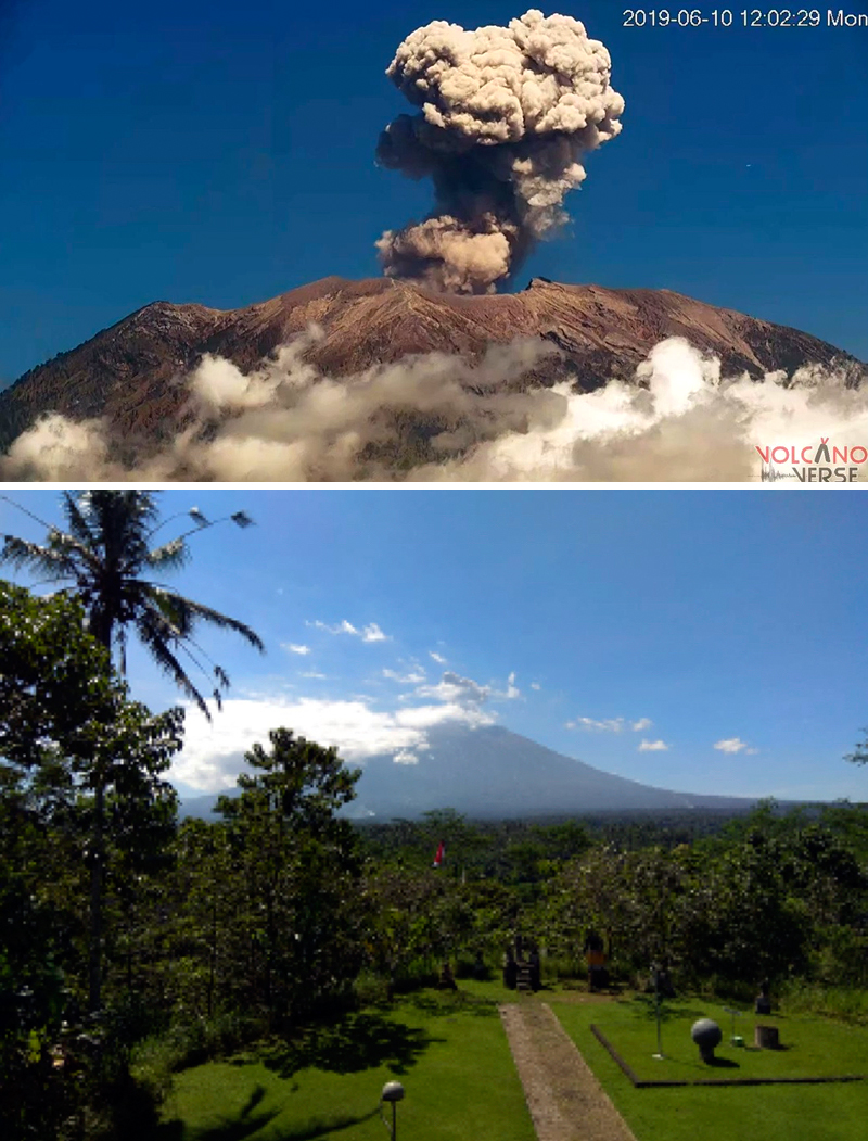 |
Figure 58. An ash plume rose 1,000 m above the summit of Agung on 10 June 2019. Top image courtesy of Rita Bauer (Volcano Verse), bottom image courtesy of PVMBG (Information on G. Agung Eruption, 10 June 2019). |
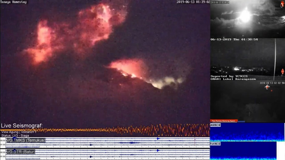 |
Figure 59. A large eruption at Agung at 0138 local time on 13 June 2019 sent an ash plume to 9.1 km altitude and incandescent ejecta 700 m in all directions. Courtesy of Jaime S. Sincioco, screenshot from volcano YT webcam. |
Although no further surface activity was reported at Agung during July through October 2019, PVMBG kept the Alert Level at III throughout the period. Only steam plumes were reported from the summit usually rising 50 m before dissipating. Steam emissions rose to 150 m a few times each month. Plumes were reported at 300 m above the summit on 6 July and 15 August. No thermal anomalies were visible in Sentinel 2 satellite images during the period.
Information Contacts: Pusat Vulkanologi dan Mitigasi Bencana Geologi (PVMBG, also known as Indonesian Center for Volcanology and Geological Hazard Mitigation, CVGHM), Jalan Diponegoro 57, Bandung 40122, Indonesia (URL: http://www.vsi.esdm.go.id/); MIROVA (Middle InfraRed Observation of Volcanic Activity), a collaborative project between the Universities of Turin and Florence (Italy) supported by the Centre for Volcanic Risk of the Italian Civil Protection Department (URL: http://www.mirovaweb.it/); Rita Bauer, Volcano Verse (Twitter @wischweg, URL: https://twitter.com/wischweg/status/1137956367258570752); Jamie S. Sincioco, Philippines (Twitter @jaimessincioco, URL: https://twitter.com/jaimessincioco/status/1139109685796020224).
Three eruptive events reported in April, May, and December 2022
Mount Agung, located on the E end of the island of Bali, Indonesia, rises above the SE rim of the Batur caldera. The summit area extends 1.5 km E-W, with the highest point on the W and a steep-walled 800-m-wide crater on the E. Recorded eruptions date back to the early 19th century. A large and deadly explosive and effusive eruption occurred during 1963-64, which was characterized by voluminous ashfall, pyroclastic flows, and lahars that caused extensive damage and many fatalities. More recent activity was documented during November 2017-June 2019 that consisted of multiple explosions, significant ash plumes, lava flows at the summit crater, and incandescent ejecta. This report covers activity reported during April-May 2022 and December 2022 based on data from the Darwin Volcanic Ash Advisory Center (VAAC).
Activity during 2022 was relatively low and mainly consisted of a few ash plumes during April-May and December. An ash plume on 3 April rising to 3.7 km altitude (700 m above the summit) and drifting N was reported in a Darwin VAAC notice based on a ground report, with ash seen in HIMAWARI-8 visible imagery. Another ash plume was reported at 1120 on 27 May that rose to 5.5 km altitude (2.5 m above the summit); the plume was not visible in satellite or webcam images due to weather clouds. An eruption was reported based on seismic data at 0840 on 13 December, with an estimated plume altitude of 3.7 km; however, no ash was seen using satellite imagery in clear conditions before weather clouds obscured the summit.
Information Contacts: Darwin Volcanic Ash Advisory Centre (VAAC), Bureau of Meteorology, Northern Territory Regional Office, PO Box 40050, Casuarina, NT 0811, Australia (URL: http://www.bom.gov.au/info/vaac/).
|
|
||||||||||||||||||||||||||
There is data available for 5 confirmed eruptive periods.
[ 2022 Dec 13 - 2022 Dec 13 ] Uncertain Eruption
| Episode 1 | Uncertain | |||||||||||||||||||
|---|---|---|---|---|---|---|---|---|---|---|---|---|---|---|---|---|---|---|---|
| 2022 Dec 13 - 2022 Dec 13 | Evidence from Observations: Seismicity | ||||||||||||||||||
| An eruption was reported based on seismic data at 0840 on 13 December 2022, with an estimated plume altitude of 3.7 km (700 m above the summit); however, no ash was seen using satellite imagery in clear conditions before weather clouds obscured the summit. | |||||||||||||||||||
|
List of 2 Events for Episode 1
|
|||||||||||||||||||
2022 Apr 3 - 2022 May 27 Confirmed Eruption (Explosive / Effusive) VEI: 1
| Episode 1 | Eruption (Explosive / Effusive) | ||||||||||||||||||||||||
|---|---|---|---|---|---|---|---|---|---|---|---|---|---|---|---|---|---|---|---|---|---|---|---|---|
| 2022 Apr 3 - 2022 May 27 | Evidence from Observations: Reported | |||||||||||||||||||||||
| An ash plume on 3 April 2022 rising to 3.7 km altitude (700 m above the summit) and drifting N was reported in a Darwin VAAC notice based on a ground report, with ash seen in HIMAWARI-8 visible imagery. Another ash plume was reported at 1120 on 27 May 2022 that rose to 5.5 km altitude (2.5 m above the summit); the plume was not visible in satellite or webcam images due to weather clouds. | ||||||||||||||||||||||||
|
List of 3 Events for Episode 1
|
||||||||||||||||||||||||
2017 Nov 21 - 2019 Jun 13 Confirmed Eruption (Explosive / Effusive) VEI: 3
Unrest that began in mid-August 2017 increased over the next six weeks, resulting in significant evacuations that reached over 140,000 people by early October. Explosive eruptions began on 21 November, leading to ash plumes reaching move than 6 km above the summit on 27 November. Lava effusion in the summit crater had filled it to 1/3 full by 16 December. Ash plume frequency and heights decreased from February through early June 2018, until a larger eruption on 15 June. Another episode the same pattern, with a pulse of lava effusion on 27 June, accompanied by ash explosions into mid-August. Thermal anomalies suggested minor lava effusion in the crater during September-December, but no explosive activity. An explosion on 30 December indicated the start of another new episode that included a lava flow and intermittent ash plumes through 13 June 2019.
| Episode 1 | Non-eruptive (Precursory) | Summit crater | ||||||||||||||||||||||||||||||||||||||||||||||||||||||||||||||||||||||||||||||||||||||||||||||||||||||||||||||||||||||||||||||||||||||||||||||||||||||||||||||||||||||||
|---|---|---|---|---|---|---|---|---|---|---|---|---|---|---|---|---|---|---|---|---|---|---|---|---|---|---|---|---|---|---|---|---|---|---|---|---|---|---|---|---|---|---|---|---|---|---|---|---|---|---|---|---|---|---|---|---|---|---|---|---|---|---|---|---|---|---|---|---|---|---|---|---|---|---|---|---|---|---|---|---|---|---|---|---|---|---|---|---|---|---|---|---|---|---|---|---|---|---|---|---|---|---|---|---|---|---|---|---|---|---|---|---|---|---|---|---|---|---|---|---|---|---|---|---|---|---|---|---|---|---|---|---|---|---|---|---|---|---|---|---|---|---|---|---|---|---|---|---|---|---|---|---|---|---|---|---|---|---|---|---|---|---|---|---|---|---|---|---|---|
| 2017 Aug 10 - 2017 Nov 21 | Evidence from Observations: Seismicity | ||||||||||||||||||||||||||||||||||||||||||||||||||||||||||||||||||||||||||||||||||||||||||||||||||||||||||||||||||||||||||||||||||||||||||||||||||||||||||||||||||||||||
| PVMBG reported that signs of renewed unrest appeared as an increase in the rate of deep volcanic earthquakes (VA or Vulkanik Dalam) beginning on 10 August 2017. Shallow volcanic earthquakes (VB or Vulkanik Dangkal) began to increase on 24 August, followed by an increase in the number of local tectonic earthquakes on 26 August. During September, seismicity continued to increase and steam and gas emissions were observed above the crater rim. Voluntary evacuations began. By 4 October BNPB reported that the number of evacuees reached 141,213 (spread out in 416 shelters) from 78 villages, though about 2,600 in locations outside of the evacuation zone were returning home; there were 28 villages (about 70,000 people) within the evacuation zone. By the first week of October, shallow earthquakes had increased to more than 200 per day. Narrow steam plumes rose 50-200 m above the summit crater during the first half of October. On 7 October a VONA noted a steam plume rising 1,500 m above the summit crater at 1245 UTC and drifting E. During the second half of the month steam plumes were denser and rose more frequently to 200-500 m above the summit crater. A decline in seismicity beginning on 20 October continued through mid-November, with tens of daily events as opposed to hundreds and dense white steam plumes rose 50-500 m above the summit crater. A VONA issued late on 11 November reported a 500-m-high steam plume. The first ash emission of the eruption occurred on 21 November at 1705 local time. | |||||||||||||||||||||||||||||||||||||||||||||||||||||||||||||||||||||||||||||||||||||||||||||||||||||||||||||||||||||||||||||||||||||||||||||||||||||||||||||||||||||||||
|
List of 32 Events for Episode 1 at Summit crater
|
|||||||||||||||||||||||||||||||||||||||||||||||||||||||||||||||||||||||||||||||||||||||||||||||||||||||||||||||||||||||||||||||||||||||||||||||||||||||||||||||||||||||||
| Episode 2 | Eruption (Explosive / Effusive) | Summit crater | ||||||||||||||||||||||||||||||||||||||||||||||||||||||||||||||||||||||||||||||||||||||||||||||||||||||||||||||||||||||||||||||||||||||||||||||||||||||||||||||||||||||||||||||||||||||||||||||||||||||||||||||||||||||||||||||||||||||||||||||||||||||||||||||||||||||||||||||||||||||||||||||||||||||||||||||||||||||||||||||||||||||||||||||||||||||||||||||||||||||||||||||||||||||||||||||||||||||||||||||||||||||||||||||||||||||||||||||||||||||||||||||||||||||||||||||||||||||||||||||||||||||||||||||||||||||||||||||||||||||||||||||||||||||||||
|---|---|---|---|---|---|---|---|---|---|---|---|---|---|---|---|---|---|---|---|---|---|---|---|---|---|---|---|---|---|---|---|---|---|---|---|---|---|---|---|---|---|---|---|---|---|---|---|---|---|---|---|---|---|---|---|---|---|---|---|---|---|---|---|---|---|---|---|---|---|---|---|---|---|---|---|---|---|---|---|---|---|---|---|---|---|---|---|---|---|---|---|---|---|---|---|---|---|---|---|---|---|---|---|---|---|---|---|---|---|---|---|---|---|---|---|---|---|---|---|---|---|---|---|---|---|---|---|---|---|---|---|---|---|---|---|---|---|---|---|---|---|---|---|---|---|---|---|---|---|---|---|---|---|---|---|---|---|---|---|---|---|---|---|---|---|---|---|---|---|---|---|---|---|---|---|---|---|---|---|---|---|---|---|---|---|---|---|---|---|---|---|---|---|---|---|---|---|---|---|---|---|---|---|---|---|---|---|---|---|---|---|---|---|---|---|---|---|---|---|---|---|---|---|---|---|---|---|---|---|---|---|---|---|---|---|---|---|---|---|---|---|---|---|---|---|---|---|---|---|---|---|---|---|---|---|---|---|---|---|---|---|---|---|---|---|---|---|---|---|---|---|---|---|---|---|---|---|---|---|---|---|---|---|---|---|---|---|---|---|---|---|---|---|---|---|---|---|---|---|---|---|---|---|---|---|---|---|---|---|---|---|---|---|---|---|---|---|---|---|---|---|---|---|---|---|---|---|---|---|---|---|---|---|---|---|---|---|---|---|---|---|---|---|---|---|---|---|---|---|---|---|---|---|---|---|---|---|---|---|---|---|---|---|---|---|---|---|---|---|---|---|---|---|---|---|---|---|---|---|---|---|---|---|---|---|---|---|---|---|---|---|---|---|---|---|---|---|---|---|---|---|---|---|---|---|---|---|---|---|---|---|---|---|---|---|---|---|---|---|---|---|---|---|---|---|---|---|---|---|---|---|---|---|---|---|---|---|---|---|---|---|---|---|---|---|---|---|---|---|---|---|---|---|---|---|---|---|---|---|---|---|---|---|---|---|---|---|---|---|---|---|---|---|---|---|---|---|---|---|---|---|---|---|---|---|---|---|---|---|---|---|---|---|---|---|---|---|---|---|---|---|---|---|---|---|---|---|---|---|---|---|---|---|---|---|---|---|---|---|---|---|---|---|---|---|---|---|---|---|---|---|---|---|---|---|---|---|---|---|
| 2017 Nov 21 - 2018 Jun 16 | Evidence from Observations: Reported | ||||||||||||||||||||||||||||||||||||||||||||||||||||||||||||||||||||||||||||||||||||||||||||||||||||||||||||||||||||||||||||||||||||||||||||||||||||||||||||||||||||||||||||||||||||||||||||||||||||||||||||||||||||||||||||||||||||||||||||||||||||||||||||||||||||||||||||||||||||||||||||||||||||||||||||||||||||||||||||||||||||||||||||||||||||||||||||||||||||||||||||||||||||||||||||||||||||||||||||||||||||||||||||||||||||||||||||||||||||||||||||||||||||||||||||||||||||||||||||||||||||||||||||||||||||||||||||||||||||||||||||||||||||||||||
| On 21 November 2017 at 0905 UTC an eruption plume rose 700 m above the summit, resulting in trace amounts of ashfall reported in the Pidpid-Nawehkerti area ~9 km SE. This was followed by intermittent explosions with ash plumes rising to 7.9 km altitude (4.9 km above the summit) for several days. On 25 November crater incandescence was observed at 2100, signifying lava in the crater. A larger explosion on 27 November produced an ash plume that rose to 9.1 km altitude and produced ashfall up to 5 mm thick in many communities. Intermittent ash plumes continued through the end of 2017, with the largest plume on 24 December reaching 10.7 km altitude (7.7 km above the summit). By 16 December the summit crater was about 1/3 full of lava, an estimated 20 million cubic meters. Frequent ash emissions rising up to 6.1 km altitude were reported during January 2018, but growth of the lava dome in the crater had slowed. Ash plume frequency decreased from February through early June 2018 with plume heights rarely exceeding 1 km above the summit, until a larger eruption on 15 June 2018 sent plumes out in two directions at three different altitudes; 7.0 km, 5.5 km, and 3 km, causing ashfall in nearby communities. | |||||||||||||||||||||||||||||||||||||||||||||||||||||||||||||||||||||||||||||||||||||||||||||||||||||||||||||||||||||||||||||||||||||||||||||||||||||||||||||||||||||||||||||||||||||||||||||||||||||||||||||||||||||||||||||||||||||||||||||||||||||||||||||||||||||||||||||||||||||||||||||||||||||||||||||||||||||||||||||||||||||||||||||||||||||||||||||||||||||||||||||||||||||||||||||||||||||||||||||||||||||||||||||||||||||||||||||||||||||||||||||||||||||||||||||||||||||||||||||||||||||||||||||||||||||||||||||||||||||||||||||||||||||||||||
|
List of 106 Events for Episode 2 at Summit crater
|
|||||||||||||||||||||||||||||||||||||||||||||||||||||||||||||||||||||||||||||||||||||||||||||||||||||||||||||||||||||||||||||||||||||||||||||||||||||||||||||||||||||||||||||||||||||||||||||||||||||||||||||||||||||||||||||||||||||||||||||||||||||||||||||||||||||||||||||||||||||||||||||||||||||||||||||||||||||||||||||||||||||||||||||||||||||||||||||||||||||||||||||||||||||||||||||||||||||||||||||||||||||||||||||||||||||||||||||||||||||||||||||||||||||||||||||||||||||||||||||||||||||||||||||||||||||||||||||||||||||||||||||||||||||||||||
| Episode 3 | Eruption (Explosive / Effusive) | Summit crater | |||||||||||||||||||||||||||||||||||||||||||||||||||||||||||||||||||||||||||||||||||||||||||||||||||||||||||||||||||||||||||||||||||||||||||||||||||||||||||||||||||||||||||||||||||||||||||||||||||||||||||||||||||||||||||||||||||||||||||||||||||||||||||||||||||||||||||||||||||||||||||||||||||||||||||||||||||||||||||||||||||||||||||||||||||||||||||||||||||||||||||||||||||||||||||||||||||||||||||||||||||
|---|---|---|---|---|---|---|---|---|---|---|---|---|---|---|---|---|---|---|---|---|---|---|---|---|---|---|---|---|---|---|---|---|---|---|---|---|---|---|---|---|---|---|---|---|---|---|---|---|---|---|---|---|---|---|---|---|---|---|---|---|---|---|---|---|---|---|---|---|---|---|---|---|---|---|---|---|---|---|---|---|---|---|---|---|---|---|---|---|---|---|---|---|---|---|---|---|---|---|---|---|---|---|---|---|---|---|---|---|---|---|---|---|---|---|---|---|---|---|---|---|---|---|---|---|---|---|---|---|---|---|---|---|---|---|---|---|---|---|---|---|---|---|---|---|---|---|---|---|---|---|---|---|---|---|---|---|---|---|---|---|---|---|---|---|---|---|---|---|---|---|---|---|---|---|---|---|---|---|---|---|---|---|---|---|---|---|---|---|---|---|---|---|---|---|---|---|---|---|---|---|---|---|---|---|---|---|---|---|---|---|---|---|---|---|---|---|---|---|---|---|---|---|---|---|---|---|---|---|---|---|---|---|---|---|---|---|---|---|---|---|---|---|---|---|---|---|---|---|---|---|---|---|---|---|---|---|---|---|---|---|---|---|---|---|---|---|---|---|---|---|---|---|---|---|---|---|---|---|---|---|---|---|---|---|---|---|---|---|---|---|---|---|---|---|---|---|---|---|---|---|---|---|---|---|---|---|---|---|---|---|---|---|---|---|---|---|---|---|---|---|---|---|---|---|---|---|---|---|---|---|---|---|---|---|---|---|---|---|---|---|---|---|---|---|---|---|---|---|---|---|---|---|---|---|---|---|---|---|---|---|---|---|---|---|---|---|---|---|---|---|---|---|---|---|---|---|---|---|---|---|---|---|---|---|---|---|---|---|---|---|---|---|---|---|---|---|---|---|---|---|---|---|---|---|
| 2018 Jun 27 - 2018 Aug 17 | Evidence from Observations: Reported | |||||||||||||||||||||||||||||||||||||||||||||||||||||||||||||||||||||||||||||||||||||||||||||||||||||||||||||||||||||||||||||||||||||||||||||||||||||||||||||||||||||||||||||||||||||||||||||||||||||||||||||||||||||||||||||||||||||||||||||||||||||||||||||||||||||||||||||||||||||||||||||||||||||||||||||||||||||||||||||||||||||||||||||||||||||||||||||||||||||||||||||||||||||||||||||||||||||||||||||||||||
| A sudden pulse of thermal energy and lava effusion into the crater on 27 June 2018 was accompanied by explosions and several days of continuous ash emissions observed in satellite and webcam imagery. Multiple explosions produced repeated daily ash plumes during the first half of July, with ash reaching 7.3 km altitude (4.3 km above the summit) on 2 July. The volume of lava in the crater was estimated and 27 million cubic meters by 4 July. Decreasing numbers of MODVOLC thermal alerts continued through July, and decreasing frequency of ash emissions continued into mid-August when activity ceased. MODVOLC alerts in October 2018 were the result of fires and not volcanic activity. | ||||||||||||||||||||||||||||||||||||||||||||||||||||||||||||||||||||||||||||||||||||||||||||||||||||||||||||||||||||||||||||||||||||||||||||||||||||||||||||||||||||||||||||||||||||||||||||||||||||||||||||||||||||||||||||||||||||||||||||||||||||||||||||||||||||||||||||||||||||||||||||||||||||||||||||||||||||||||||||||||||||||||||||||||||||||||||||||||||||||||||||||||||||||||||||||||||||||||||||||||||||
|
List of 79 Events for Episode 3 at Summit crater
|
||||||||||||||||||||||||||||||||||||||||||||||||||||||||||||||||||||||||||||||||||||||||||||||||||||||||||||||||||||||||||||||||||||||||||||||||||||||||||||||||||||||||||||||||||||||||||||||||||||||||||||||||||||||||||||||||||||||||||||||||||||||||||||||||||||||||||||||||||||||||||||||||||||||||||||||||||||||||||||||||||||||||||||||||||||||||||||||||||||||||||||||||||||||||||||||||||||||||||||||||||||
| Episode 4 | Eruption (Explosive / Effusive) | Summit crater | |||||||||||||
|---|---|---|---|---|---|---|---|---|---|---|---|---|---|---|
| 2018 Sep 10 (on or after) ± 5 days - 2019 Jan 10 (on or before) ± 5 days | Evidence from Observations: Satellite (infrared) | |||||||||||||
| No MODVOLC or VAAC data were reported during September-December 2018, but low-level heat flow identified by MIROVA analysis suggests minor ongoing lava activity inside the summit crater. Ash explosions resumed at the end of December 2018. | ||||||||||||||
|
List of 1 Events for Episode 4 at Summit crater
|
||||||||||||||
| Episode 5 | Eruption (Explosive / Effusive) | Summit crater | |||||||||||||||||||||||||||||||||||||||||||||||||||||||||||||||||||||||||||||||||||||||||||||||||||||||||||||||||||||||||||||||||||||||||||||||||||||||||||||||||||||||||||||||||||||||||||||||||||||||||||||||||||||||||||||||||||||||||||||||||||||||||||||||||||||||||||||||||||||||||||||||||||||||||||||||||||||||||||||||||||||||||||||||||||||||||||||||||||||||||||||||||||||||||||||||||||||||||||||||||||||||||||||||||||||||||||||||||||||||||||||||||||||||||||||||||||||||||||||||||||||||||||||||||||||||||||||||||||||||||||||||||||||||||||||||||||||||||
|---|---|---|---|---|---|---|---|---|---|---|---|---|---|---|---|---|---|---|---|---|---|---|---|---|---|---|---|---|---|---|---|---|---|---|---|---|---|---|---|---|---|---|---|---|---|---|---|---|---|---|---|---|---|---|---|---|---|---|---|---|---|---|---|---|---|---|---|---|---|---|---|---|---|---|---|---|---|---|---|---|---|---|---|---|---|---|---|---|---|---|---|---|---|---|---|---|---|---|---|---|---|---|---|---|---|---|---|---|---|---|---|---|---|---|---|---|---|---|---|---|---|---|---|---|---|---|---|---|---|---|---|---|---|---|---|---|---|---|---|---|---|---|---|---|---|---|---|---|---|---|---|---|---|---|---|---|---|---|---|---|---|---|---|---|---|---|---|---|---|---|---|---|---|---|---|---|---|---|---|---|---|---|---|---|---|---|---|---|---|---|---|---|---|---|---|---|---|---|---|---|---|---|---|---|---|---|---|---|---|---|---|---|---|---|---|---|---|---|---|---|---|---|---|---|---|---|---|---|---|---|---|---|---|---|---|---|---|---|---|---|---|---|---|---|---|---|---|---|---|---|---|---|---|---|---|---|---|---|---|---|---|---|---|---|---|---|---|---|---|---|---|---|---|---|---|---|---|---|---|---|---|---|---|---|---|---|---|---|---|---|---|---|---|---|---|---|---|---|---|---|---|---|---|---|---|---|---|---|---|---|---|---|---|---|---|---|---|---|---|---|---|---|---|---|---|---|---|---|---|---|---|---|---|---|---|---|---|---|---|---|---|---|---|---|---|---|---|---|---|---|---|---|---|---|---|---|---|---|---|---|---|---|---|---|---|---|---|---|---|---|---|---|---|---|---|---|---|---|---|---|---|---|---|---|---|---|---|---|---|---|---|---|---|---|---|---|---|---|---|---|---|---|---|---|---|---|---|---|---|---|---|---|---|---|---|---|---|---|---|---|---|---|---|---|---|---|---|---|---|---|---|---|---|---|---|---|---|---|---|---|---|---|---|---|---|---|---|---|---|---|---|---|---|---|---|---|---|---|---|---|---|---|---|---|---|---|---|---|---|---|---|---|---|---|---|---|---|---|---|---|---|---|---|---|---|---|---|---|---|---|---|---|---|---|---|---|---|---|---|---|---|---|---|---|---|---|---|---|---|---|---|---|---|---|---|---|---|---|---|---|---|---|---|---|---|---|---|---|---|---|---|---|---|---|---|---|---|---|---|---|---|---|---|---|---|---|---|---|---|---|---|---|---|---|
| 2018 Dec 30 - 2019 Jun 13 | Evidence from Observations: Reported | |||||||||||||||||||||||||||||||||||||||||||||||||||||||||||||||||||||||||||||||||||||||||||||||||||||||||||||||||||||||||||||||||||||||||||||||||||||||||||||||||||||||||||||||||||||||||||||||||||||||||||||||||||||||||||||||||||||||||||||||||||||||||||||||||||||||||||||||||||||||||||||||||||||||||||||||||||||||||||||||||||||||||||||||||||||||||||||||||||||||||||||||||||||||||||||||||||||||||||||||||||||||||||||||||||||||||||||||||||||||||||||||||||||||||||||||||||||||||||||||||||||||||||||||||||||||||||||||||||||||||||||||||||||||||||||||||||||||||
| An explosion on 30 December 2018, after no explosive activity since August 2018, resulted in ash plumes to 5.5 km altitude (2.5 km above the summit) and caused ashfall in nearby communities. Intermittent explosions continued through 13 June 2019. Two larger explosions on 31 May and 13 June produced ash plumes that rose to 8.2 and 9.1 km (5.2 and 6.1 km above the summit) respectively, and included audible noises and incandescent ejecta around the flanks. Intermittent thermal anomalies indicated ongoing incandescent ejecta and a lava flow that was observed on 24 May. Only steam and gas emissions were reported after 13 June 2019. | ||||||||||||||||||||||||||||||||||||||||||||||||||||||||||||||||||||||||||||||||||||||||||||||||||||||||||||||||||||||||||||||||||||||||||||||||||||||||||||||||||||||||||||||||||||||||||||||||||||||||||||||||||||||||||||||||||||||||||||||||||||||||||||||||||||||||||||||||||||||||||||||||||||||||||||||||||||||||||||||||||||||||||||||||||||||||||||||||||||||||||||||||||||||||||||||||||||||||||||||||||||||||||||||||||||||||||||||||||||||||||||||||||||||||||||||||||||||||||||||||||||||||||||||||||||||||||||||||||||||||||||||||||||||||||||||||||||||||||
|
List of 109 Events for Episode 5 at Summit crater
|
||||||||||||||||||||||||||||||||||||||||||||||||||||||||||||||||||||||||||||||||||||||||||||||||||||||||||||||||||||||||||||||||||||||||||||||||||||||||||||||||||||||||||||||||||||||||||||||||||||||||||||||||||||||||||||||||||||||||||||||||||||||||||||||||||||||||||||||||||||||||||||||||||||||||||||||||||||||||||||||||||||||||||||||||||||||||||||||||||||||||||||||||||||||||||||||||||||||||||||||||||||||||||||||||||||||||||||||||||||||||||||||||||||||||||||||||||||||||||||||||||||||||||||||||||||||||||||||||||||||||||||||||||||||||||||||||||||||||||
1963 Feb 18 - 1964 Jan 27 Confirmed Eruption (Explosive / Effusive) VEI: 5
| Episode 1 | Eruption (Explosive / Effusive) | |||||||||||||||||||||||||||||||||||||||||||||||||||||||||||||||||||||||||||||||||||||||||||||||||||||||||||||||||||||||||||||||||
|---|---|---|---|---|---|---|---|---|---|---|---|---|---|---|---|---|---|---|---|---|---|---|---|---|---|---|---|---|---|---|---|---|---|---|---|---|---|---|---|---|---|---|---|---|---|---|---|---|---|---|---|---|---|---|---|---|---|---|---|---|---|---|---|---|---|---|---|---|---|---|---|---|---|---|---|---|---|---|---|---|---|---|---|---|---|---|---|---|---|---|---|---|---|---|---|---|---|---|---|---|---|---|---|---|---|---|---|---|---|---|---|---|---|---|---|---|---|---|---|---|---|---|---|---|---|---|---|---|---|
| 1963 Feb 18 - 1964 Jan 27 | Evidence from Observations: Reported | ||||||||||||||||||||||||||||||||||||||||||||||||||||||||||||||||||||||||||||||||||||||||||||||||||||||||||||||||||||||||||||||||
| This devastating began on 18 February 1963. Andesitic lava flowed down the N flank to a distance of 7 km beginning on 19 February and ended with the major 17 March explosion, followed by another major explosion on 16 May. Both produced voluminous ashfall, pyroclastic flows, and lahars that killed more than 1,100 people. | |||||||||||||||||||||||||||||||||||||||||||||||||||||||||||||||||||||||||||||||||||||||||||||||||||||||||||||||||||||||||||||||||
|
List of 24 Events for Episode 1
|
|||||||||||||||||||||||||||||||||||||||||||||||||||||||||||||||||||||||||||||||||||||||||||||||||||||||||||||||||||||||||||||||||
1843 Confirmed Eruption (Explosive / Effusive) VEI: 5
| Episode 1 | Eruption (Explosive / Effusive) | ||||||||||||||||||||||||||||||||||
|---|---|---|---|---|---|---|---|---|---|---|---|---|---|---|---|---|---|---|---|---|---|---|---|---|---|---|---|---|---|---|---|---|---|---|
| 1843 - Unknown | Evidence from Observations: Reported | |||||||||||||||||||||||||||||||||
| Work by Fontijn et al. (2015) showed that the tephra deposit from this eruption was clearly thicker and coarser than the 1963 eruption (VEI 5), so this eruption has also been assigned as a VEI 5. | ||||||||||||||||||||||||||||||||||
|
List of 5 Events for Episode 1
|
||||||||||||||||||||||||||||||||||
[ 1821 Mar 16 ] Uncertain Eruption
| Episode 1 | Eruption (Explosive / Effusive) | ||||||||||||||||||||||||
|---|---|---|---|---|---|---|---|---|---|---|---|---|---|---|---|---|---|---|---|---|---|---|---|---|
| 1821 Mar 16 - Unknown | Evidence from Unknown | |||||||||||||||||||||||
| Thick white smoke noted in Sapper (1917). | ||||||||||||||||||||||||
|
List of 3 Events for Episode 1
|
||||||||||||||||||||||||
1808 Confirmed Eruption (Explosive / Effusive) VEI: 2
| Episode 1 | Eruption (Explosive / Effusive) | |||||||||||||||||||
|---|---|---|---|---|---|---|---|---|---|---|---|---|---|---|---|---|---|---|---|
| 1808 - Unknown | Evidence from Observations: Reported | ||||||||||||||||||
| An explosive eruption was reported in 1808 CE (Neumann van Padang, 1951 CAVW). | |||||||||||||||||||
|
List of 2 Events for Episode 1
|
|||||||||||||||||||
This compilation of synonyms and subsidiary features may not be comprehensive. Features are organized into four major categories: Cones, Craters, Domes, and Thermal Features. Synonyms of features appear indented below the primary name. In some cases additional feature type, elevation, or location details are provided.
Synonyms |
||||
| Bali, Peak of | Agoeng | Carang Assam | ||||
Cones |
||||
| Feature Name | Feature Type | Elevation | Latitude | Longitude |
| Agung | Stratovolcano | 2997 m | 8° 20' 24.00" S | 115° 29' 55.00" E |
| Pawon | Cone | 1045 m | 8° 24' 29.00" S | 115° 31' 7.00" E |
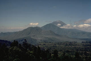 This view from the NW rim of the massive 10 x 13 km outer caldera of Batur volcano looks across the caldera to Gunung Abang (center) on the SE caldera rim. Lake Batur (right) banks against the SE wall of the outer caldera and overlies the rim of the 7.5-km-wide inner caldera. Historically active Gunung Batur stratovolcano (left-center) was constructed along a NE-SW-trending line in the center of the inner caldera of Batur volcano. The large stratovolcano in the distance is Gunung Agung, Bali's highest volcano.
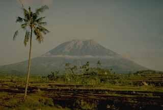 Agung volcano towers over the eastern end of the island of Bali. A steep-walled, 200-m deep crater is located at the summit of the 3142-m-high volcano. Only three eruptions have been recorded in historical time; the latest, in 1963-64, produced devastating pyroclastic flows and lahars.
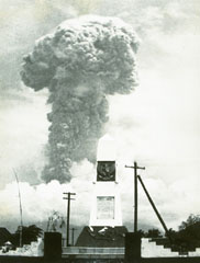 An ash plume towers above Bali's Agung volcano on 12 March 1963. Five days later a devastating eruption produced pyroclastic flows and lahars that killed 1,148 people. Another powerful eruption on 16 May caused additional fatalities. The eruption left tens of thousands homeless.
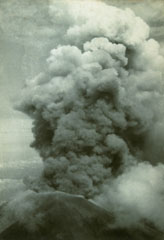 An ash plume rises above the summit crater of Agung volcano on 17 March 1963 during the first of two powerful explosive eruptions that caused much devastation to the island of Bali. The eruption began on 19 February with a lava flow that traveled down the N flank. Major explosive events occurred on 17 March and 16 May that produced devastating pyroclastic flows and lahars that killed more than 1,100 people.
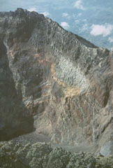 The summit of Bali's Gunung Agung contains a 500-m-wide, 200-m-deep crater that is the source of the historical eruptions. Gray lava flows and brown tephra layers from explosive eruptions are exposed in the crater wall.
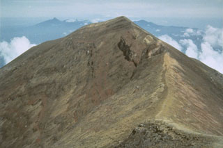 The summit of Agung marks the highest point on the island of Bali. The broad irregular massif in the far distance is the 11 x 6 km wide Bratan caldera.
 Agung is located at the eastern end of the island of Bali. A 200-m-deep crater is located at the summit of the volcano, seen here from the Sakta River on the eastern flank. Eruptions have been recorded in historical time including an episode during 1963-64 that produced devastating pyroclastic flows and lahars.
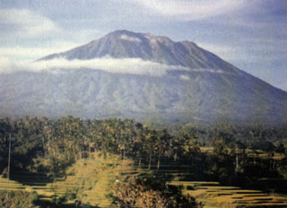 Gunung Agung towers above rice fields near the Rendang volcano observation post. The stratovolcano has erupted infrequently during historical time, but its 1963 eruption was one of the most devastating in Indonesia during the 20th century.
 The following 7 samples associated with this volcano can be found in the Smithsonian's NMNH Department of Mineral Sciences collections, and may be availble for research (contact the Rock and Ore Collections Manager). Catalog number links will open a window with more information.
| Catalog Number | Sample Description | Lava Source | Collection Date |
|---|---|---|---|
| NMNH 116957-1 | Scoria | -- | 1 Oct 1979 |
| NMNH 116957-2 | Scoria | -- | 1 Oct 1979 |
| NMNH 116957-3 | Lava | -- | -- |
| NMNH 117584-1 | Andesite | -- | -- |
| NMNH 117584-2 | Andesite | -- | -- |
| NMNH 117584-3 | Ash | -- | -- |
| NMNH 117584-4 | Andesite | -- | -- |
| Copernicus Browser | The Copernicus Browser replaced the Sentinel Hub Playground browser in 2023, to provide access to Earth observation archives from the Copernicus Data Space Ecosystem, the main distribution platform for data from the EU Copernicus missions. |
| MIROVA | Middle InfraRed Observation of Volcanic Activity (MIROVA) is a near real time volcanic hot-spot detection system based on the analysis of MODIS (Moderate Resolution Imaging Spectroradiometer) data. In particular, MIROVA uses the Middle InfraRed Radiation (MIR), measured over target volcanoes, in order to detect, locate and measure the heat radiation sourced from volcanic activity. |
| MODVOLC Thermal Alerts | Using infrared satellite Moderate Resolution Imaging Spectroradiometer (MODIS) data, scientists at the Hawai'i Institute of Geophysics and Planetology, University of Hawai'i, developed an automated system called MODVOLC to map thermal hot-spots in near real time. For each MODIS image, the algorithm automatically scans each 1 km pixel within it to check for high-temperature hot-spots. When one is found the date, time, location, and intensity are recorded. MODIS looks at every square km of the Earth every 48 hours, once during the day and once during the night, and the presence of two MODIS sensors in space allows at least four hot-spot observations every two days. Each day updated global maps are compiled to display the locations of all hot spots detected in the previous 24 hours. There is a drop-down list with volcano names which allow users to 'zoom-in' and examine the distribution of hot-spots at a variety of spatial scales. |
|
WOVOdat
Single Volcano View Temporal Evolution of Unrest Side by Side Volcanoes |
WOVOdat is a database of volcanic unrest; instrumentally and visually recorded changes in seismicity, ground deformation, gas emission, and other parameters from their normal baselines. It is sponsored by the World Organization of Volcano Observatories (WOVO) and presently hosted at the Earth Observatory of Singapore.
GVMID Data on Volcano Monitoring Infrastructure The Global Volcano Monitoring Infrastructure Database GVMID, is aimed at documenting and improving capabilities of volcano monitoring from the ground and space. GVMID should provide a snapshot and baseline view of the techniques and instrumentation that are in place at various volcanoes, which can be use by volcano observatories as reference to setup new monitoring system or improving networks at a specific volcano. These data will allow identification of what monitoring gaps exist, which can be then targeted by remote sensing infrastructure and future instrument deployments. |
| Volcanic Hazard Maps | The IAVCEI Commission on Volcanic Hazards and Risk has a Volcanic Hazard Maps database designed to serve as a resource for hazard mappers (or other interested parties) to explore how common issues in hazard map development have been addressed at different volcanoes, in different countries, for different hazards, and for different intended audiences. In addition to the comprehensive, searchable Volcanic Hazard Maps Database, this website contains information about diversity of volcanic hazard maps, illustrated using examples from the database. This site is for educational purposes related to volcanic hazard maps. Hazard maps found on this website should not be used for emergency purposes. For the most recent, official hazard map for a particular volcano, please seek out the proper institutional authorities on the matter. |
| IRIS seismic stations/networks | Incorporated Research Institutions for Seismology (IRIS) Data Services map showing the location of seismic stations from all available networks (permanent or temporary) within a radius of 0.18° (about 20 km at mid-latitudes) from the given location of Agung. Users can customize a variety of filters and options in the left panel. Note that if there are no stations are known the map will default to show the entire world with a "No data matched request" error notice. |
| UNAVCO GPS/GNSS stations | Geodetic Data Services map from UNAVCO showing the location of GPS/GNSS stations from all available networks (permanent or temporary) within a radius of 20 km from the given location of Agung. Users can customize the data search based on station or network names, location, and time window. Requires Adobe Flash Player. |
| DECADE Data | The DECADE portal, still in the developmental stage, serves as an example of the proposed interoperability between The Smithsonian Institution's Global Volcanism Program, the Mapping Gas Emissions (MaGa) Database, and the EarthChem Geochemical Portal. The Deep Earth Carbon Degassing (DECADE) initiative seeks to use new and established technologies to determine accurate global fluxes of volcanic CO2 to the atmosphere, but installing CO2 monitoring networks on 20 of the world's 150 most actively degassing volcanoes. The group uses related laboratory-based studies (direct gas sampling and analysis, melt inclusions) to provide new data for direct degassing of deep earth carbon to the atmosphere. |
| Large Eruptions of Agung | Information about large Quaternary eruptions (VEI >= 4) is cataloged in the Large Magnitude Explosive Volcanic Eruptions (LaMEVE) database of the Volcano Global Risk Identification and Analysis Project (VOGRIPA). |
| EarthChem | EarthChem develops and maintains databases, software, and services that support the preservation, discovery, access and analysis of geochemical data, and facilitate their integration with the broad array of other available earth science parameters. EarthChem is operated by a joint team of disciplinary scientists, data scientists, data managers and information technology developers who are part of the NSF-funded data facility Integrated Earth Data Applications (IEDA). IEDA is a collaborative effort of EarthChem and the Marine Geoscience Data System (MGDS). |

