
PVMBG reported that during 17-18 and 20-22 April white steam-and-gas plumes rose as high as 100 m above the summit of Lewotobi’s Laki-laki volcano and drifted N, NE, and E. On 23 April a white-and-gray ash plume rose 100-200 m and drifted SW and W. The Alert Level remained at 2 (the second lowest level on a scale of 1-4) and the public was warned to stay outside of the exclusion zone, defined as a 2-km radius around Laki-laki crater, 3 km to the NNE, and 5 km on the NE flanks.
Source: Pusat Vulkanologi dan Mitigasi Bencana Geologi (PVMBG, also known as CVGHM)
Occasional increases in seismicity and white plumes during August 2011-October 2015
Lewotobi is composed of the Lewotobi Lakilaki (man) and Lewotobi Perempuan (woman) stratovolcanoes, with summit craters less than 2 km apart on Flores Island (figure 2). The last explosive eruption occurred in May 2003, accompanied by a high level of seismicity (BGVN 28:10). The volcano was apparently quiet through the middle of 2011, except for a brief period of unrest in May 2008 (BGVN 34:01) and March 2009 (BGVN 34:04). The report reviews activity through 7 October 2015, mostly from Pusat Vulkanologi dan Mitigasi Bencana Geologi (PVMBG) reports unless otherwise noted.
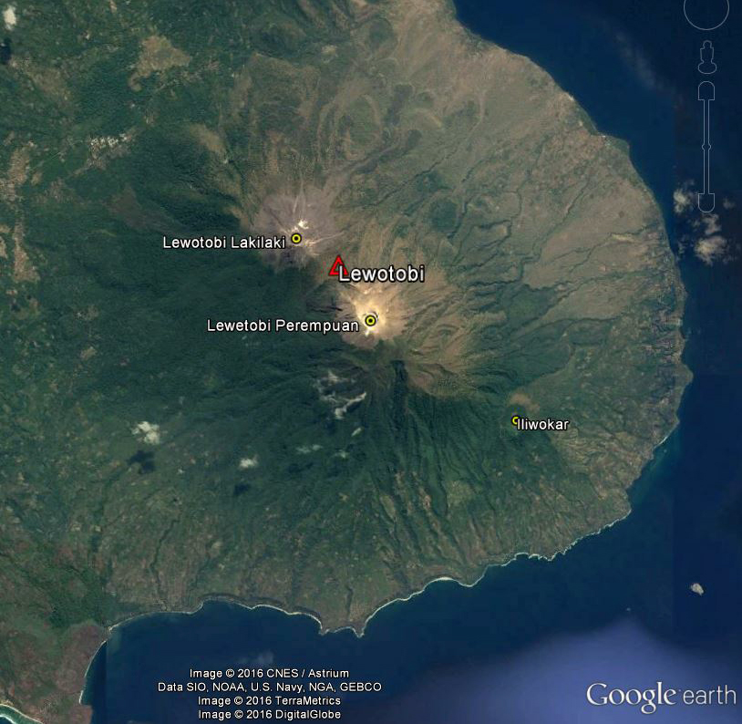 |
Figure 2. Satellite image from 4 September 2013 showing Lewotobi volcano and associated features on eastern Flores Island: the two stratovolcanoes Lakilaki and Perempuan, and SE flank cone Iliwokar. The crater on the smaller Lakilaki edifice to the NW is 400 m wide, while Perempuan's is 700 m wide. Courtesy of Google Earth; data labels provided by GVP. |
Seismicity increased during 26-31 August 2011, and plumes of "smoke" rose 15-50 m above the Perampuan crater rim. Based on the seismic data, the Alert Level for that crater was raised to 2 (Caution) (on a scale of 1-4) on 31 August. Increased seismicity and visual observations at Lakilaki after 17 September 2011 prompted PVMBG to raise the Alert Level to 2 for that cone as well on 22 September. Diffuse white plumes rose 15 m above the crater. At Alert Level 2 people are prohibited from going within a 1-km radius of the respective volcano.
Diffuse white plumes again rose 15-25 m above the summits of both craters during January-March 2012. Seismicity at both fluctuated, but had declined overall during September 2011-March 2012. The Alert Level at both was reduced from 2 to 1 (Normal) on 29 March 2012. Another period of increased seismicity on 28 September 2013 prompted PVMBG to again raise the Alert Level of Perempuan to 2.
Based on analysis of satellite images and wind data, the Darwin Volcanic Ash Advisory Centre (VAAC) reported that on 6 October 2014 a narrow, low-level ash plume from Lewotobi rose to an altitude of 3 km and drifted 185 km WNW. However, PVMBG did not report activity of any kind or raise the Alert Level. MODVOLC thermal alert pixels for that date showed a broad area on the E flank with 15 scattered anomalies extending to the shoreline, and three pixels the day before located just SE (figure 3). An alternate hypothesis is that fires spread NW due to prevailing winds, sending a low-level plume in that direction.
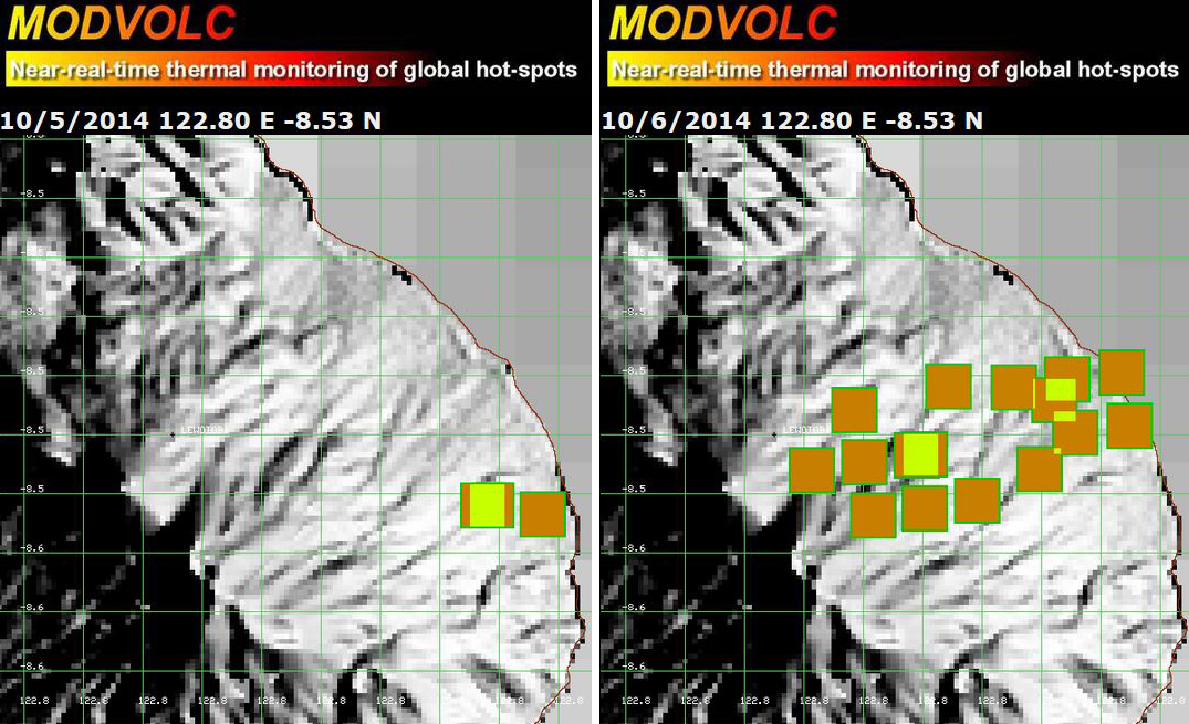 |
Figure 3. MODVOLC maps showing thermal alert pixels at Lewotobi on 5 October (left) and 6 October (right) 2014. Courtesy of Hawai'i Institute of Geophysics and Planetology (HIGP), MODVOLC Thermal Alerts System. |
White plumes were reported by PVMBG to be rising 15-20 m above Lakilaki during periods of clear weather from 1 February to 17 March 2015. Seismicity increased significantly on 13 March, especially the number of volcanic earthquakes and shallow volcanic earthquakes; harmonic tremor, tornillo events, and tectonic events were also detected. On 17 March the Alert Level was raised to 2. On 7 October 2015, PVMBG lowered the Alert Level to 1, based on visual observations and decreased seismicity over the previous three months.
Clear weather revealed white plumes rising 15 m above Perempuan during 17 July-25 August and 1 September-6 October 2015. Though the Alert Level had been raised on an unreported day, seismicity declined significantly after 1 August, and on 27 August, the Alert Level was lowered to 1.
Information Contacts: Pusat Vulkanologi dan Mitigasi Bencana Geologi (PVMBG, also known as CVGHM, Center for Volcanology and Geological Hazard Mitigation), Jl. Diponegoro 57, Bandung, West Java, Indonesia, 40 122 (URL: http://www.vsi.esdm.go.id/); Darwin Volcanic Ash Advisory Centre (VAAC), Bureau of Meteorology, Northern Territory Regional Office, PO Box 40050, Casuarina, NT 0811, Australia (URL: http://www.bom.gov.au/info/vaac/); Hawai'i Institute of Geophysics and Planetology (HIGP), MODVOLC Thermal Alerts System, School of Ocean and Earth Science and Technology (SOEST), Univ. of Hawai'i, 2525 Correa Road, Honolulu, HI 96822, USA (URL: http://modis.higp.hawaii.edu/).
2024: January
| February
| March
| April
2023: December
2015: March
| August
| October
2014: October
2012: March
2011: August
| September
2009: March
2008: May
2003: June
| July
| August
| October
2002: October
PVMBG reported that during 17-18 and 20-22 April white steam-and-gas plumes rose as high as 100 m above the summit of Lewotobi’s Laki-laki volcano and drifted N, NE, and E. On 23 April a white-and-gray ash plume rose 100-200 m and drifted SW and W. The Alert Level remained at 2 (the second lowest level on a scale of 1-4) and the public was warned to stay outside of the exclusion zone, defined as a 2-km radius around Laki-laki crater, 3 km to the NNE, and 5 km on the NE flanks.
Source: Pusat Vulkanologi dan Mitigasi Bencana Geologi (PVMBG, also known as CVGHM)
PVMBG reported that on 11 and 14 April white-and-gray plumes rose 100-500 m above the summit of Lewotobi’s Laki-laki volcano and drifted N and E. White plumes rose as high as 150 m above the summit and drifted in multiple directions during 10, 12-13, and 15-16 April. Incandescence at the summit was visible in a 14 April webcam image. An eruptive event was recorded on 15 April, though no emissions were observed, possibly due to weather conditions. The Alert Level remained at 2 (the second lowest level on a scale of 1-4) and the public was warned to stay outside of the exclusion zone, defined as a 2-km radius around Laki-laki crater, 3 km to the NNE, and 5 km on the NE flanks.
Source: Pusat Vulkanologi dan Mitigasi Bencana Geologi (PVMBG, also known as CVGHM)
PVMBG reported that white-and-gray plumes rose 50-200 m above the summit of Lewotobi’s Laki-laki volcano and drifted N, NE, and E on 6 and 9 April. White plumes rose as high as 300 m above the summit and drifted in multiple directions on 3, 5, and 7 April; no plumes were visible on 4 April. The Alert Level remained at 2 (the second lowest level on a scale of 1-4) and the public was warned to stay outside of the exclusion zone, defined as a 2-km radius around Laki-laki crater, 3 km to the NNE, and 5 km on the NE flanks.
Source: Pusat Vulkanologi dan Mitigasi Bencana Geologi (PVMBG, also known as CVGHM)
PVMBG reported that white-and-gray plumes rose 100-500 m above the summit of Lewotobi’s Laki-laki volcano during 29-30 March. White plumes rose 20-50 m above the summit and drifted N and NE on 27 March; no plumes were visible on 28 and 31 March and during 1-2 April. PVMBG lowered the Alert Level to 2 (the second lowest level on a scale of 1-4) at 1900 on 1 March and the public was warned to stay outside of the exclusion zone, defined as a 2-km radius around Laki-laki crater, 3 km to the NNE, and 5 km on the NE flanks.
Source: Pusat Vulkanologi dan Mitigasi Bencana Geologi (PVMBG, also known as CVGHM)
Pusat Vulkanologi dan Mitigasi Bencana Geologi (PVMBG) reported that white emissions rose as high as 100 m above the summit of Lewotobi Laki-laki during 20-26 March. Some rockfall events were detected by the seismic network. There were no visual observations of renewed lava effusion, and no reports of lava flow movement since 20 February. The Alert Level remained at Level 2 (on a scale of 1-4), and the public was warned to remain outside of the hazard zone, defined as a 2-km radius around the crater, the 3-km NNE sector expansion, and the 5-km NE sector expansion; both sector expansions extend from the established 2-km hazard radius.
Source: Pusat Vulkanologi dan Mitigasi Bencana Geologi (PVMBG, also known as CVGHM)
PVMBG reported that white plumes rose as high as 300 m above the summit of Lewotobi’s Laki-laki volcano during 28 February-5 March. According to a news article, seismicity and visual observations showed that activity decreased during 22-29 February. Drone footage indicated that the lava flow was cooling, and effusion had stopped, though the flow may continue to slowly advance due to gravity, the slope of the ground, and the high temperature. PVMBG lowered the Alert Level to 2 (the second lowest level on a scale of 1-4) at 1900 on 1 March and the public was warned to stay outside of the exclusion zone, defined as a 2-km radius around Laki-laki crater, 3 km to the NNE, and 5 km on the NE flanks.
Sources: Pusat Vulkanologi dan Mitigasi Bencana Geologi (PVMBG, also known as CVGHM); Antara News
PVMBG reported that the eruption at Lewotobi’s Laki-laki volcano was ongoing during 13-20 February. The lava flow on the NE flank continued to be active, advancing 100 m during 3-20 February to a total length of 4.2 km. A drone overflight on 20 February confirmed the position of the end of the lava flow. White steam-and-gas plumes were visible during 13, 15, 17, and 19-20 February rising as high as 100 m above the summit and drifting N, NE, and W; no emissions were observed on 14 February. White-and-gray ash plumes rose as high as 600 m above the summit on 16 and 18 February and drifted N and NE. According to a news article, all evacuees had returned to their homes. The Alert Level remained at 3 (the second highest level on a scale of 1-4) and the public was warned to stay outside of the exclusion zone, defined as a 3-km radius around Laki-laki crater, 4 km to the NNE, and 5 km on the NE flanks.
Sources: Pusat Vulkanologi dan Mitigasi Bencana Geologi (PVMBG, also known as CVGHM); Antara News; Antara News
PVMBG reported that Lewotobi Laki-laki continued to erupt during 7-13 February. White emissions rose 30-700 m above the summit during 7 February, and 20–50 m above the summit during 8-11, and 13 February. A seismograph recorded eruptive events at 0807 on 7 February, 1858 on 9 February, 1806 on 10 February, and 1249 on 12 February. Dense, white to gray ash plumes rose 500-700 m above the summit and drifted N and NE during the eruptive events on 7 and 9 February. The Alert Level remained at 3 (the second highest level on a scale of 1-4) and the public was warned to stay outside of the exclusion zone, defined as a 4 km radius around Laki-laki crater, 5 km to the NNE, and 6 km on the NE flanks.
Source: Pusat Vulkanologi dan Mitigasi Bencana Geologi (PVMBG, also known as CVGHM)
PVMBG reported that the eruption at Lewotobi’s Laki-laki volcano was ongoing during 31 January-6 February. Incandescence at the summit and from the lava flow on the NE flank was visible in webcam images during the week. On 31 January dense white-and-gray ash plumes rose as high as 700 m above the summit and drifted N and NE. At 0825 on 2 February a white-and-gray ash plume rose 700 m and drifted N and a pyroclastic flow descended the N flank as far as 500 m. An eruptive event was recorded at 1248 but it was not observed. At 1429 a dense white-and-gray ash plume rose as high as 1.5 km and drifted N. White steam-and-gas plumes were visible on the other days rising to 500 m above the summit and drifting N, NE, and S; no emissions were observed on 4 February. The Alert Level remained at 3 (the second highest level on a scale of 1-4) and the public was warned to stay outside of the exclusion zone, defined as a 4-km radius around Laki-laki crater, 5 km to the NNE, and 6 km on the NE flanks.
Sources: Pusat Vulkanologi dan Mitigasi Bencana Geologi (PVMBG, also known as CVGHM); Antara News; Antara News
PVMBG reported that the eruption at Lewotobi’s Laki-laki volcano had decreased during 23-29 January based on visual and instrumental data. The lava flow on the NE flank continued to advance, reaching a length of 4 km, though the rate of advancement had slowed by 23 January, possibly due to gentler topography, a decrease in the effusion rate, or a combination of both. A total of 11 pyroclastic flows were detected and traveled 1-2 km N, NNE, and NE, though average distances were closer to 1 km. Eruption plume heights decreased from an average of 1.5 km above the summit to 500 m. The seismic network recorded a total of 388 lava avalanches that traveled as far as 1.5 km N and NE. Sulfur dioxide emissions significantly decreased, and deformation data indicated deflation. Analysis of deep volcanic earthquakes and low-frequency earthquakes both indicated a decrease in the supply of magma to the surface. At 1200 on 29 January the Alert Level was lowered to 3 (the second highest level on a scale of 1-4) and the public was warned to stay outside of the exclusion zone, defined as a 4-km radius around Laki-laki Crater, 5 km to the NNE, and 6 km on the NE flanks.
Sources: Pusat Vulkanologi dan Mitigasi Bencana Geologi (PVMBG, also known as CVGHM); Antara News
PVMBG reported that the eruption at Lewotobi’s Laki-laki volcano was ongoing during 16-23 January. Dense white-and-gray or white, gray, and brown ash plumes rose as high as 1.5 km above the summit and drifted NW, N, NE, and E. Lava flows from the summit crater continued down the N flank and were almost 3.8 km long by 23 January, according to a news article. Lava avalanches and pyroclastic flows occasionally descended the N, NW, and SW flanks during the week; lava avalanches traveled at most 2 km down the SW flank on 16 January. The Alert Level remained at 4 (the highest level on a scale of 1-4) and the public was warned to stay outside of the exclusion zone, defined as a 5-km radius around Laki-laki Crater and 6 km from the crater on the N and NE flanks.
Sources: Pusat Vulkanologi dan Mitigasi Bencana Geologi (PVMBG, also known as CVGHM); Antara News; Antara News; Antara News; Antara News; Antara News
PVMBG reported that the eruption at Lewotobi’s Laki-laki volcano was ongoing during 10-16 January. Dense white-and-gray or white, gray, and brown ash plumes rose as high as 2 km above the summit and drifted N and NE. Lava flows from the summit crater continued to advance down the N flank and were about 2 km long by 11 January. Rumbling was reported on 13 January. On 14 January as many as four pyroclastic flows traveled up to 1 km down the NE, N, and NNW flanks and lava avalanches traveled 1.5-2 km down the NE flank, according to news articles. Incandescent avalanches of material and accompanying pyroclastic flows traveled as far as 1.5 km N on 15 January. Incandescent avalanches also traveled 2-3 km NE and 1 km NNE. The exclusion zone was increased to 5 km from the Laki-laki Crater and 6 km from the crater on the N and NE flanks during the evening of 16 January. The Alert Level remained at 4 (the highest level on a scale of 1-4).
Sources: Pusat Vulkanologi dan Mitigasi Bencana Geologi (PVMBG, also known as CVGHM); Antara News; Antara News; Antara News; Antara News; Antara News
PVMBG reported that the eruption at Lewotobi’s Laki-laki volcano from a fissure on the upper NNW flank and from a vent on the upper SSE flank was ongoing during 3-9 January. White plumes rose 300-1,000 m above the summit and drifted SW and W during 3-5 December. During the rest of the week white-and-gray or gray-to-brown ash plumes rose 1-1.5 km above the summit and drifted NW, N, and NE. The ash plumes were sometimes dense.
Masks had been distributed in Hokeng Jaya, Pululera, Klatanlo, and Nawakote in the district of Wulanggitan and the village of Dulempari in the district of Bura after the eruption began in late December and residents were encouraged to wear them when outside to minimize ash inhalation. On 1 January as many as 1,185 residents of Boru Village and 328 residents in the Konga Village area self-evacuated to several other locations including relatives’ homes and evacuation posts. Ash fell in several areas in the Wulanggitan and Bura districts. Badan Penanggulangan Bencana Daerah (BPBD) East Flores Regency mobilized and provided residents with essentials including mobile kitchens, food, tents, and cleaned ash off roadways. By 4 January a total of 3,898 people had evacuated. The Frans Xavier Seda Airport in Sikka District closed on 1 January due to thick ash deposits on the runways; it remained closed as of 9 January.
Activity intensified during the evening of 9 January. Incandescent material was ejected from the summit and lava flows from the NNW-flank fissure descended the NW flank. At 2300 the Alert Level was raised to 4 (on a scale of 1-4) and the public was warned to stay 4 km away from the Perempuan and Laki-laki craters and an additional 5 km from the NNW flanks of Laki-laki.
Sources: Pusat Vulkanologi dan Mitigasi Bencana Geologi (PVMBG, also known as CVGHM); Badan Nacional Penanggulangan Bencana (BNPB); Badan Penanggulangan Bencana Daerah Provinsi Jawa Timur (East Java BPBD); Directorate General Of Civil Aviation, Ministry Of Transportation Republic Of Indonesia
PVMBG reported that seismicity at Lewotobi had increased on 12 December and was followed by the emergence of “tornillo” earthquakes indicating fluid movement at depth. An eruption occurred on 23 December at Laki-laki and lasted about 24 minutes. A 160-m-long fissure on the upper NW flank was visible afterwards and it emitted dense white plumes that rose 300 m. At 0253 on 28 December an observer noted a dense white-and-gray ash plume that rose 1 km above the summit and drifted NW. On 1 January the amplitude of continuous tremors increased. A new vent opened along a fissure located on the upper SSE flank and produced a white, gray, and black ash plume that rose 1-1.5 km above the summit. The Alert Level was raised to 3 (on a scale of 1-4) at 1600 and the public was warned to stay 3 km away from the Perempuan and Laki-laki craters and an additional 4 km from the NNW and SSE flanks of Laki-laki. At 0454 on 2 January a gray-to-brown ash plume rose 1.5 km above the summit and drifted SW and W.
Source: Pusat Vulkanologi dan Mitigasi Bencana Geologi (PVMBG, also known as CVGHM)
PVMBG reported that an eruption at Lewotobi’s Laki-laki, the NW of two large adjacent stratovolcanoes, occurred at 0714 on 23 December and lasted about 24 minutes. The Aviation Color Code was raised to Orange (the third level on a four-color scale). Dense gray ash plumes rose 1-1.5 km above the summit and drifted N. The eruption was preceded by about a week of increased seismicity. The Alert Level remained at 2 (on a scale of 1-4) and the public was warned to stay 2 km away from the active summit crater.
Source: Pusat Vulkanologi dan Mitigasi Bencana Geologi (PVMBG, also known as CVGHM)
On 17 December seismicity at Lewotobi increased significantly, prompting PVMBG to raise the Alert Level to 2 (on a scale of 1-4). Seismicity had been increasing during the previous week and was characterized by greater numbers of both deep and shallow volcanic earthquakes, and the emergence of tornillo-type earthquakes which indicated fluid movement. The public was warned to stay 2 km away from the craters at each summit.
Source: Pusat Vulkanologi dan Mitigasi Bencana Geologi (PVMBG, also known as CVGHM)
PVMBG reported that white plumes were observed rising 15 m above Lewotobi during periods of clear weather from 1 Septmber-6 October. Seismicity declined significantly during the previous three months and became stable. The Alert Level was lowered to 1 (on a scale of 1-4) on 7 October.
Source: Pusat Vulkanologi dan Mitigasi Bencana Geologi (PVMBG, also known as CVGHM)
PVMBG reported that white plumes were observed rising 15 m above Lewotobi during periods of clear weather from 17 July to 25 August. Seismicity decreased significantly during 1-25 August. The Alert Level was lowered to 1 (on a scale of 1-4).
Source: Pusat Vulkanologi dan Mitigasi Bencana Geologi (PVMBG, also known as CVGHM)
PVMBG reported that white plumes were observed rising 15-20 m above Lewotobi during periods of clear weather from 1 February to17 March. Seismicity increased significantly on 13 March, especially volcanic earthquakes and shallow volcanic earthquakes; harmonic tremor, Tornillo events, and tectonic events were also detected. On 17 March the Alert Level was raised to 2 (on a scale of 1-4). Residents and tourists were warned not to approach the craters within a 1-km radius.
Source: Pusat Vulkanologi dan Mitigasi Bencana Geologi (PVMBG, also known as CVGHM)
Based on analysis of satellite images and wind data, the Darwin VAAC reported that on 6 October a narrow, low-level ash plume from Lewotobi rose to an altitude of 3 km (10,000 ft) a.s.l. and drifted 185 km WNW.
Source: Darwin Volcanic Ash Advisory Centre (VAAC)
CVGHM reported that seismicity at Lewotobi Lakilaki, one of two stratovolcanoes comprising Lewotobi, fluctuated but declined overall during 18 September 2011-25 March 2012. No significant changes were observed at the volcano. The Alert Level was lowered to 1 (on a scale of 1-4) on 29 March.
Observers of Lewotobi Perempuan, the second stratovolcano comprising Lewotobi, noted that during January-March diffuse white plumes rose 15 m above the crater and no significant changes had occurred. After 31 August 2011 through 25 March 2012 seismicity fluctuated but declined overall. On 29 March the Alert Level was lowered to 1.
Source: Pusat Vulkanologi dan Mitigasi Bencana Geologi (PVMBG, also known as CVGHM)
CVGHM raised the Alert Level for Lewotobi Lakilaki, one of two stratovolcanoes composing Lewotobi, to 2 (on a scale of 1-4) on 22 September due to increased seismicity since 17 September and visual observations. Although no significant changes in the volcano were observed, diffuse white plumes rose 15 m above the crater. Visitors and residents were prohibited from going within a 1-km radius of Lewotobi Lakilaki.
Source: Pusat Vulkanologi dan Mitigasi Bencana Geologi (PVMBG, also known as CVGHM)
CVGHM reported that during 26-31 August seismicity at Lewotobi increased. Plumes of "smoke" rose 15-50 m above the Lewotobi Perampuan crater rim; no other significant changes were visibly apparent. Based on the seismic data, the Alert Level was raised to 2 (on a scale of 1-4) on 31 August. Visitors and residents were advised not to approach the volcano within 1 km of the Lewotobi Perampuan crater.
Source: Pusat Vulkanologi dan Mitigasi Bencana Geologi (PVMBG, also known as CVGHM)
On 23 March, CVGHM lowered the Alert Level for Lewotobi from 2 to 1 (on a scale of 1-4) based on visual observations and decreased seismicity during March. Rarely seen diffuse white plumes rose 25 m above the crater and drifted E. Visitors and residents were advised not to approach the crater.
Source: Pusat Vulkanologi dan Mitigasi Bencana Geologi (PVMBG, also known as CVGHM)
On 29 May, CVGHM raised the Alert Level for Lewotobi to 2 (on a scale of 1-4) due to an increase in seismicity during 12-29 May. White plumes typically rose about 25 m above the crater and drifted E; visual observations indicated no changes.
Source: Pusat Vulkanologi dan Mitigasi Bencana Geologi (PVMBG, also known as CVGHM)
A decrease in volcanic activity at Lewotobi during 13-19 October led DVGHM to decrease the Alert Level from 2 to 1 (on a scale of 1-4). Only gas was emitted to low levels and no volcanic earthquakes were recorded.
Source: Pusat Vulkanologi dan Mitigasi Bencana Geologi (PVMBG, also known as CVGHM)
The Darwin VAAC reported that an eruption at Lewotobi on 1 September produced an ash plume to a height of ~2.5 km above the summit that drifted W. Volcanic material caused fires in forests within a 1 km radius of the crater and damaged crops on the volcano's flanks. VSI raised the Alert Level to 4, the highest level. According to news articles, hundreds of people from at least six villages fled their homes for the village of Konga to the E. By 2 September the Alert Level had been reduced to 3.
Sources: Darwin Volcanic Ash Advisory Centre (VAAC); Agence France-Presse (AFP)
Low-level ash emissions continued at Lewotobi during 2-29 June. During 2-8 June ash plumes reached ~300 m above the summit, and ash fell in the villages of Bawalatang, Duang, and Boru. Lewotobi remained at Alert Level 2 (on a scale of 1-4).
Source: Pusat Vulkanologi dan Mitigasi Bencana Geologi (PVMBG, also known as CVGHM)
On 30 May at 1650 an ash explosion at Lewotobi Lakilaki, a stratovolcano of Lewotobi, sent an ash column to a height of ~200 m above the summit. Ash fell at the observatory post about 5 km from the crater. As of 1 June, Lewotobi was at Alert Level 2 (on a scale of 1-4).
Source: Pusat Vulkanologi dan Mitigasi Bencana Geologi (PVMBG, also known as CVGHM)
On 12 October at 2330 there was an explosion at Lewotobi Lakilaki, a stratovolcano of Lewotobi, that was accompanied by a weak thundering sound. Ash fell as far as 5 km away and an ash column rose ~500 m above the volcano. According to VSI, eruptions at Lewotobi usually occur over an extended period of time, therefore they expect more explosions to take place in the next couple of weeks to months. On 16 October, Lewotobi was at Alert Level 4 (the highest level).
Sources: Darwin Volcanic Ash Advisory Centre (VAAC); Pusat Vulkanologi dan Mitigasi Bencana Geologi (PVMBG, also known as CVGHM)
Reports are organized chronologically and indexed below by Month/Year (Publication Volume:Number), and include a one-line summary. Click on the index link or scroll down to read the reports.
Brief increase in seismicity
A sudden increase in seismicity, from 7 to 60 earthquakes/day, was recorded at the end of March. Activity peaked on 26 March, then gradually decreased. No changes in surface activity were observed.
Information Contacts: W. Modjo, VSI.
Ash emission follows increased seismicity
Ash was erupted to 800 m height, and deposited to 7 km NE and 4 km NW, on 11-13 May. Gas emission continued through the end of May, with 84 emission events recorded during the last week. Twelve shallow and seven deep volcanic earthquakes were also recorded during the last week in May.
Information Contacts: W. Modjo, VSI.
Strombolian activity; ash to 300 m height; several hundred explosion earthquakes weekly
Explosions at the summit crater on 28 May at 1615, 1840, and 1911 produced ash clouds to 300 m, accompanied by thunder-like sounds heard 4 km SW of the crater (at Pos Observatory). Since then, activity has been dominated by gas emissions and explosion earthquakes (figure 1). Explosions emitted ash (12-19 times/week) to 100-300 m high. On 8 and 13 June, lapilli and bombs ejected by Strombolian activity covered the area surrounding the crater. Glow and lava fountaining then steadily diminished through the end of June. Explosion earthquakes were recorded 200-405 times/week, compared to 0-4 deep and shallow volcanic earthquakes, and 5-7 tectonic earthquakes/week. No tremor episodes were recorded.
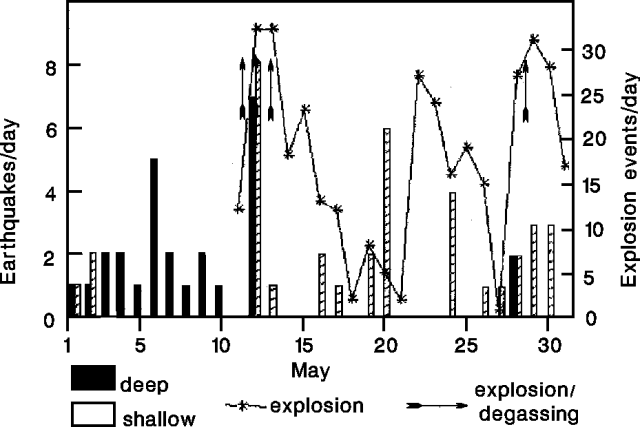 |
Figure 1. Daily number of earthquakes and explosion events at Lewotobi Lakilaki, May 1991. Arrows represent explosions. Courtesy of VSI. |
Information Contacts: W. Modjo, VSI.
Strombolian activity
Press releases reported increased activity, with small eruptions occurring around 19 July. One eruption reportedly ejected incandescent material 100 m high, dropping hot ash (smelling of sulfur) onto nearby areas and causing residents to flee. At 1645 on 29 July, a 300-m-high ash cloud extending ~35 km W was reported by pilots on Qantas flight A61. By the week of 14-19 August the volcano was no longer exploding, and gas emissions, 50-100 m high, appeared to be decreasing.
Information Contacts: W. Modjo, VSI; ICAO; UPI.
Continued gas emission
Degassing has continued since October, sometimes punctuated by ash ejection reaching 50-150 m above the crater. The number of degassing earthquakes dropped slightly from 246 during the first week of December to 233 in the second week. One B-type volcanic earthquake was recorded during the two-week period.
Information Contacts: VSI.
March-May ash eruptions
The current phase of activity at Lewotobi Lakilaki began at 0547 on 21 March, when observers noted a vigorous steam plume rising 250 m above the summit. This was noteworthy because when the volcano is in a non-active phase its steam plume rises no higher than ~25 m. On 30 March a rumbling noise was heard and the volcano's status was raised to Level II, or "Alert." The following day observers twice noted ash plumes ~250 m high accompanied by a rumbling noise. On 1 April observers saw such plumes at three different times.
From 27 April to 3 May the ash eruption continued. The observed ash was whitish-gray, of weak to moderate pressure, and extending 300 m above the summit. Eruption events were sometimes accompanied by detonations. On 29 April, glowing material was ejected 50-75 m above the crater and it fell over an area with 50 m radius. Thin ash fell over the Boru area the following day at 1600. The seismic record totals for the week showed four volcanic type-B, nine tectonic, four eruption, and nine emission events.
Ash eruptions reached heights of 500 m during 4-10 May and were sometimes accompanied by strong detonations. On 7 and 9 May glowing materials were again ejected to 50-75 m heights, falling within a 50 m radius. On 7 May ash fell around the areas of Boru, Riang Boru, Hokeng, and Wolorona. Deposits were ~1 mm thick. Seismic events for the week decreased, with three eruptive and five emission events. From 11 through 17 May ash eruptions continued to reach heights of 500 m and were sometimes accompanied by strong detonations. During the week of 18-24 May emission heights decreased to 300 m and blast sounds became less frequent. Thin ash fell during 19 May on the Boru and Riagulu regions.
Information Contacts: Volcanological Survey of Indonesia (VSI), Jalan Diponegoro No. 57, Bandung 40122, Indonesia (URL: http://www.vsi.esdm.go.id/).
1 July explosion ignites fires and up to 1 mm of ash falls on local villages
Lewotobi Laki-Laki erupted at 1000 on 1 July. A strong blast accompanied the eruption. Glowing material fell in a 500 m radius to the N and S, igniting forest fires that extended 2.5 km N of the crater and 500 m S, to the ridge dividing Lewotobi Laki-Laki from Lewotobi Perempuan. Ash emissions reached 1,000 m above the summit and were distributed to the W, SW, and S. The emissions then drifted to the NW, W, SW, and S in an 8-km radius. The settlements of Boru, Bawalatang, and Watukubu reported ash deposits in the range 0.5-1 mm thick.
"White, thin-to-thick ash emissions" have continued since the initial eruption, rising ~100 m above the summit. Authorities raised the volcano status to "Level III" (prepare to evacuate) on 2 July. The seismic record for the week 29 June to 5 July reported 266 type-A, 70 type-B, two tectonic, and 31 explosive events.
Information Contacts: R. Sukhyar and Dali Ahmad, Volcanological Survey of Indonesia (VSI), Jalan Diponegoro No. 57, Bandung 40122, Indonesia (URL: http://www.vsi.esdm.go.id/).
Explosion on 12 October 2002, the first reported activity since July 1999
On 12 October 2002 at 2330, an explosion at Lewotobi Lakilaki (a twin stratovolcano of Lewotobi Perempuan) was accompanied by a weak thundering sound that was heard at Hokeng village, 5 km from the summit. An ash column rose ~500 m above the volcano and drifted NW. Ash fell as far as 5 km away, accumulating to thicknesses of less than 0.5 mm. No seismic data were available. Following the eruption, the Alert Level was raised to 2 (on a scale of 1-4). According to VSI, eruptions at Lewotobi usually occur over an extended time, therefore more explosions were expected in the following weeks to months. VSI reported no increase in volcanism in the weeks following the 12 October eruption. Through at least 24 November, a thin white low-pressure ash plume was frequently visible rising 150-250 m above the summit. Lewotobi remained at Alert Level 2.
Information Contacts: Dali Ahmad, Volcanological Survey of Indonesia (VSI), Jalan Diponegoro No. 57, Bandung 40122, Indonesia (URL: http://www.vsi.esdm.go.id/).
Minor explosion and ashfall on 30 May
An explosion on 12 October 2002 at Lewotobi Lakilaki, one of the twin stratovolcanoes that comprise Lewotobi, produced an ash column that rose ~500 m above the volcano (BGVN 27:11). Through at least 24 November, a "thin white low-pressure ash plume" rose 150-250 m above the summit.
No further reports were issued until May 2003, when the Volcanological Survey of Indonesia reported an explosion at 1650 on 30 May 2003. The resulting ash column reached 200 m above the summit and caused ashfall at the observatory, ~5 km from the crater. Visual and seismic data showed no significant increases during the week prior to the explosion (table 1). On 1 June, two explosion earthquakes and two tremor earthquakes were recorded. The hazard status was set at Alert Level 2 (on a scale of 1-4).
Table 1. Seismicity and height of the gas plume at Lewotobi during 20 May-15 June 2003. Courtesy VSI.
| Date | Volcanic EQ | Tectonic EQ | Ash Emissions | Tremor | Plume Height(s) |
| 20 May 2003 | 2 | 1 | -- | -- | 25 m |
| 21 May 2003 | 0 | 0 | -- | -- | -- |
| 22 May 2003 | 4 | 1 | -- | -- | 25 m |
| 23 May 2003 | 9 | 5 | -- | -- | 25 m |
| 24 May 2003 | 6 | 3 | -- | -- | 25 m |
| 25 May 2003 | 5 | 1 | -- | -- | 25 m |
| 26 May 2003 | 0 | 0 | -- | -- | 25 m |
| 27 May 2003 | 2 | 6 | -- | -- | 25 m |
| 28 May 2003 | 0 | 2 | -- | -- | -- |
| 29 May 2003 | 2 | 0 | -- | -- | -- |
| 30 May 2003 | 6 | 3 | -- | -- | 200 m |
| 31 May 2003 | 6 | 0 | -- | -- | -- |
| 01 Jun 2003 | 3 | 1 | -- | -- | -- |
| 02-08 Jun 2003 | 13 | 12 | 29 | 20 | 300 m |
| 09-15 Jun 2003 | 24 | 9 | 40 | 33 | 75 m |
Activity during the week of 2-8 June 2003 was marked by explosions and ash emissions. Ash plumes reached a maximum height of 300 m above the summit. Seven explosions were recorded accompanied by a blasting sound on 3, 5, and 6 June. Ash fell at Bawalatang, Duang, and Boru villages. Shallow volcanic earthquakes were recorded, but were fewer in number compared to the previous week; there was no record of deep volcanic earthquakes, although tectonic earthquakes were recorded.
During the week of 9-15 June, activity was marked by ash emissions, with an ash plume reaching a maximum height of 75 m above the summit. Tremor events were also observed, with the tremor showing an amplitude of 0.5-7 mm. There were no deep volcanic earthquakes recorded, although the numbers of shallow volcanic earthquakes, tremor and ash emissions increased.
Information Contacts: Dali Ahmad, Volcanological Survey of Indonesia (VSI), Jalan Diponegoro No. 57, Bandung 40122, Indonesia (URL: http://www.vsi.esdm.go.id/).
Explosions and ashfall during June-July; seismicity stops in early September
Explosive ash eruptions from the summit crater of Lewotobi sent dark gray plumes 300-350 m high between 2 June and 13 July. Detonation sounds accompanied explosions on 3, 5, and 6 June. Ash fell in the villages of Bawalatang, Duang, and Boru in early June, and was reported at the volcano observatory post in early July. Ash explosions continued during 14-20 July with plumes rising 150 m above the summit. Poor weather conditions prevented observations in late July, although seismic records indicated continued activity; no reports were available for August. In early September an ash plume was reported to rise 25 m above the crater.
Seismicity during June and July was dominated by emissions events, but included tremor, explosion, and shallow volcanic earthquakes (table 2). Early September seismicity consisted of a high number of shallow volcanic events and some deep volcanic earthquakes, but all seismicity ceased after 3 September. Only four tectonic earthquakes were detected after this date, during 6-19 October. The 29 September-5 October report noted an ash plume rising to 25 m above the crater, but over the next two weeks the 25-m-high plume was described as gas emissions. The hazard status was downgraded to Alert Level 1 (on a scale of 1-4) the week of 13-19 October.
Table 2. Seismicity at Lewotobi, 2 June-19 October 2003. Note that no seismicity was recorded after 3 September 2003. Courtesy of VSI.
| Date | Deep Volcanic | Shallow Volcanic | Explosion | Emission | Tremor | Tectonic |
| 02 Jun-08 Jun 2003 | 0 | 13 | 7 | 29 | 20 | 12 |
| 09 Jun-15 Jun 2003 | 0 | 24 | -- | 40 | 33 | 9 |
| 30 Jun-06 Jul 2003 | 0 | 8 | 14 | 26 | 11 | 3 |
| 07 Jul-13 Jul 2003 | 0 | 16 | 10 | 52 | 4 | 1 |
| 14 Jul-20 Jul 2003 | 4 | 17 | 19 | 24 | 10 | 4 |
| 21 Jul-27 Jul 2003 | 1 | 10 | 5 | 25 | 5 | 4 |
| 28 Jul-03 Aug 2003 | 0 | 9 | 8 | 20 | 6 | 3 |
| 01 Sep-03 Sep 2003* | 27 | 257 | 0 | 0 | 0 | 5 |
Information Contacts: Dali Ahmad, Hetty Triastuty, Nia Haerani, and Suswati, Volcanological Survey of Indonesia (VSI), Jalan Diponegoro No. 57, Bandung 40122, Indonesia (URL: http://www.vsi.esdm.go.id/).
Increase in seismicity during May 2008; more details on 2003 eruption
On 29 May 2008, the Center of Volcanology and Geological Hazard Mitigation (CVGHM) raised the Alert Level for the Flores Island volcano Lewotobi to 2 (on a scale of 1-4) due to an increase in seismicity during 12-29 May. White plumes typically rose about 25 m above the crater and drifted E; visual observations indicated no changes.
Explosive ash eruptions and high levels of seismicity occurred during May-September 2003 (BGVN28:06 and 28:10). Seismicity declined dramatically after an eruption on 31 August, and all volcanic earthquakes ceased after 3 September. The absence of reports during October 2003 until mid-May 2008 suggests Lewotobi apparently entered a protracted period of quiescence until May 2008. MODVOLC thermal surveillance of Lewotobi subsequent to the activity of October 2003 has not revealed any significant thermal activity to February 2009.
Additional details of 2003 eruption.According to an Agence France-Presse (AFP) news report, an eruption on 31 August 2003 took place at 1935. The article noted that hundreds of people from at least six villages fled E from their homes to the village of Konga. AFP said that volcanic material caused fires in forests within a 1-km radius of the crater and damaged crops on the flanks. On 1 September CVGHM reported to the Darwin Volcanic Ash Advisory Center (VAAC) that an ash plume rose ~2.5 km above the crater and drifted W, but the plume was not detected in imagery.
Following that 2003 eruption, according to the daily Jakarta Post, at least 565 villagers living on the slopes of Lewotobi were affected by sulfur and ash emissions. The residents experienced respiratory problems and skin afflictions. A 2008 Jakarta Post article indicated that an estimated 10,000 people live on the slopes of Lewotobi, most of them farming the fertile volcanic soil in the area.
Information Contacts: Center of Volcanology and Geological Hazard Mitigation (CVGHM), Jalan Diponegoro 57, Bandung 40122, Indonesia (URL: http://vsi.esdm.go.id/); Hawai'i Institute of Geophysics and Planetology (HIGP) Thermal Alerts System, School of Ocean and Earth Science and Technology (SOEST), Univ. of Hawai'i, 2525 Correa Road, Honolulu, HI 96822, USA (URL: http://modis.higp.hawaii.edu/); Darwin Volcanic Ash Advisory Centre (VAAC), Bureau of Meteorology, Northern Territory Regional Office, PO Box 40050, Casuarina, NT 0811, Australia (URL: http://www.bom.gov.au/info/vaac/); Agence France-Presse (URL: http://www.afp.com/); Jakarta Post (URL: http://www.thejakartapost.com/).
Drops in steaming and seismicity during March 2009
Unrest caused authorities to elevate the alert level here to 2 in May 2008 (BGVN 34:01). No ash emissions were reported, as has been the case since 2003 (BGVN28:06, 28:10, 34:01).
On 23 March 2009, the Center for Volcanology and the Mitigation of Geologic Disaster (CVGHM) lowered the alert level on Lewotobi from 2 to 1 (on a scale of 1-4). This shift was based on visual observations and decreased seismicity during March. Rarely seen diffuse white plumes rose 25 m above the crater and drifted E. Visitors and residents continued to be advised not to approach the crater.
Over the period 1-23 March 2009 a cluster of shallow volcanic earthquakes occurred. Their initial numbers, 5-25 daily, soon declined to 1-5 occurrences per day. The total number of deep volcanic earthquakes did not change, averaging 1-3 daily. No tremor had been recorded since 1 February 2009 and at least as late as mid-2009.
Information Contacts: Center of Volcanology and Geological Hazard Mitigation (CVGHM), Jalan Diponegoro 57, Bandung 40122, Indonesia (URL: http://vsi.esdm.go.id/); Hawai'i Institute of Geophysics and Planetology (HIGP) Thermal Alerts System, School of Ocean and Earth Science and Technology (SOEST), Univ. of Hawai'i, 2525 Correa Road, Honolulu, HI 96822, USA (URL: http://modis.higp.hawaii.edu/); Darwin Volcanic Ash Advisory Centre (VAAC), Bureau of Meteorology, Northern Territory Regional Office, PO Box 40050, Casuarina, NT 0811, Australia (URL: http://www.bom.gov.au/info/vaac/); Agence France-Presse (URL: http://www.afp.com/); Jakarta Post (URL: http://www.thejakartapost.com/).
Occasional increases in seismicity and white plumes during August 2011-October 2015
Lewotobi is composed of the Lewotobi Lakilaki (man) and Lewotobi Perempuan (woman) stratovolcanoes, with summit craters less than 2 km apart on Flores Island (figure 2). The last explosive eruption occurred in May 2003, accompanied by a high level of seismicity (BGVN 28:10). The volcano was apparently quiet through the middle of 2011, except for a brief period of unrest in May 2008 (BGVN 34:01) and March 2009 (BGVN 34:04). The report reviews activity through 7 October 2015, mostly from Pusat Vulkanologi dan Mitigasi Bencana Geologi (PVMBG) reports unless otherwise noted.
|
Figure 2. Satellite image from 4 September 2013 showing Lewotobi volcano and associated features on eastern Flores Island: the two stratovolcanoes Lakilaki and Perempuan, and SE flank cone Iliwokar. The crater on the smaller Lakilaki edifice to the NW is 400 m wide, while Perempuan's is 700 m wide. Courtesy of Google Earth; data labels provided by GVP. |
Seismicity increased during 26-31 August 2011, and plumes of "smoke" rose 15-50 m above the Perampuan crater rim. Based on the seismic data, the Alert Level for that crater was raised to 2 (Caution) (on a scale of 1-4) on 31 August. Increased seismicity and visual observations at Lakilaki after 17 September 2011 prompted PVMBG to raise the Alert Level to 2 for that cone as well on 22 September. Diffuse white plumes rose 15 m above the crater. At Alert Level 2 people are prohibited from going within a 1-km radius of the respective volcano.
Diffuse white plumes again rose 15-25 m above the summits of both craters during January-March 2012. Seismicity at both fluctuated, but had declined overall during September 2011-March 2012. The Alert Level at both was reduced from 2 to 1 (Normal) on 29 March 2012. Another period of increased seismicity on 28 September 2013 prompted PVMBG to again raise the Alert Level of Perempuan to 2.
Based on analysis of satellite images and wind data, the Darwin Volcanic Ash Advisory Centre (VAAC) reported that on 6 October 2014 a narrow, low-level ash plume from Lewotobi rose to an altitude of 3 km and drifted 185 km WNW. However, PVMBG did not report activity of any kind or raise the Alert Level. MODVOLC thermal alert pixels for that date showed a broad area on the E flank with 15 scattered anomalies extending to the shoreline, and three pixels the day before located just SE (figure 3). An alternate hypothesis is that fires spread NW due to prevailing winds, sending a low-level plume in that direction.
|
Figure 3. MODVOLC maps showing thermal alert pixels at Lewotobi on 5 October (left) and 6 October (right) 2014. Courtesy of Hawai'i Institute of Geophysics and Planetology (HIGP), MODVOLC Thermal Alerts System. |
White plumes were reported by PVMBG to be rising 15-20 m above Lakilaki during periods of clear weather from 1 February to 17 March 2015. Seismicity increased significantly on 13 March, especially the number of volcanic earthquakes and shallow volcanic earthquakes; harmonic tremor, tornillo events, and tectonic events were also detected. On 17 March the Alert Level was raised to 2. On 7 October 2015, PVMBG lowered the Alert Level to 1, based on visual observations and decreased seismicity over the previous three months.
Clear weather revealed white plumes rising 15 m above Perempuan during 17 July-25 August and 1 September-6 October 2015. Though the Alert Level had been raised on an unreported day, seismicity declined significantly after 1 August, and on 27 August, the Alert Level was lowered to 1.
Information Contacts: Pusat Vulkanologi dan Mitigasi Bencana Geologi (PVMBG, also known as CVGHM, Center for Volcanology and Geological Hazard Mitigation), Jl. Diponegoro 57, Bandung, West Java, Indonesia, 40 122 (URL: http://www.vsi.esdm.go.id/); Darwin Volcanic Ash Advisory Centre (VAAC), Bureau of Meteorology, Northern Territory Regional Office, PO Box 40050, Casuarina, NT 0811, Australia (URL: http://www.bom.gov.au/info/vaac/); Hawai'i Institute of Geophysics and Planetology (HIGP), MODVOLC Thermal Alerts System, School of Ocean and Earth Science and Technology (SOEST), Univ. of Hawai'i, 2525 Correa Road, Honolulu, HI 96822, USA (URL: http://modis.higp.hawaii.edu/).
This compilation of synonyms and subsidiary features may not be comprehensive. Features are organized into four major categories: Cones, Craters, Domes, and Thermal Features. Synonyms of features appear indented below the primary name. In some cases additional feature type, elevation, or location details are provided.
Synonyms |
||||
| Lobetobi | Lewetobi | Lowetobi | Lebetobi | ||||
Cones |
||||
| Feature Name | Feature Type | Elevation | Latitude | Longitude |
| Iliwokar | Cone | 693 m | 8° 34' 13" S | 122° 48' 31" E |
|
Lewetobi Perempuan
Lewetobi Perampuan |
Stratovolcano | 1692 m | 8° 33' 16" S | 122° 46' 55" E |
|
Lewotobi Laki-laki
Nobo, Mount Lewotobi Lakilaki |
Stratovolcano | 1559 m | 8° 32' 21" S | 122° 46' 3" E |
|
|
||||||||||||||||||||||||
There is data available for 23 confirmed Holocene eruptive periods.
2023 Dec 23 - 2024 Apr 19 (continuing) Confirmed Eruption
| Episode 1 | Eruption Episode | ||||
|---|---|---|---|---|
| 2023 Dec 23 - 2024 Apr 19 (continuing) | Evidence from Observations: Reported | |||
[ 2014 Oct 6 - 2014 Oct 6 ] Uncertain Eruption
| Episode 1 | Eruption Episode | ||||||||||||||||||||
|---|---|---|---|---|---|---|---|---|---|---|---|---|---|---|---|---|---|---|---|---|
| 2014 Oct 6 - 2014 Oct 6 | Evidence from Observations: Reported | |||||||||||||||||||
|
List of 2 Events for Episode 1
| ||||||||||||||||||||
2003 May 30 - 2003 Sep 1 (in or after) Confirmed Eruption Max VEI: 2
| Episode 1 | Eruption Episode | Lewotobi Lakilaki | |||||||||||||||||||||||||||||||||||||||
|---|---|---|---|---|---|---|---|---|---|---|---|---|---|---|---|---|---|---|---|---|---|---|---|---|---|---|---|---|---|---|---|---|---|---|---|---|---|---|---|---|
| 2003 May 30 - 2003 Sep 1 (in or after) | Evidence from Observations: Reported | |||||||||||||||||||||||||||||||||||||||
|
List of 6 Events for Episode 1 at Lewotobi Lakilaki
| ||||||||||||||||||||||||||||||||||||||||
2002 Oct 12 - 2002 Oct 12 (?) Confirmed Eruption Max VEI: 1
| Episode 1 | Eruption Episode | Lewotobi Lakilaki | |||||||||||||||||||||||||||||
|---|---|---|---|---|---|---|---|---|---|---|---|---|---|---|---|---|---|---|---|---|---|---|---|---|---|---|---|---|---|---|
| 2002 Oct 12 - 2002 Oct 12 (?) | Evidence from Observations: Reported | |||||||||||||||||||||||||||||
|
List of 4 Events for Episode 1 at Lewotobi Lakilaki
| ||||||||||||||||||||||||||||||
1999 Mar 31 - 1999 Jul 1 (?) Confirmed Eruption Max VEI: 2
| Episode 1 | Eruption Episode | Lewotobi Lakilaki | ||||||||||||||||||||||||||||||||||||||||||||
|---|---|---|---|---|---|---|---|---|---|---|---|---|---|---|---|---|---|---|---|---|---|---|---|---|---|---|---|---|---|---|---|---|---|---|---|---|---|---|---|---|---|---|---|---|---|
| 1999 Mar 31 - 1999 Jul 1 (?) | Evidence from Observations: Reported | ||||||||||||||||||||||||||||||||||||||||||||
|
List of 7 Events for Episode 1 at Lewotobi Lakilaki
| |||||||||||||||||||||||||||||||||||||||||||||
1991 May 11 - 1992 Dec 31 (in or after) Confirmed Eruption Max VEI: 1
| Episode 1 | Eruption Episode | Lewotobi Lakilaki | ||||||||||||||||||||||||||||||||||||||||||||||||||||||
|---|---|---|---|---|---|---|---|---|---|---|---|---|---|---|---|---|---|---|---|---|---|---|---|---|---|---|---|---|---|---|---|---|---|---|---|---|---|---|---|---|---|---|---|---|---|---|---|---|---|---|---|---|---|---|---|
| 1991 May 11 - 1992 Dec 31 (in or after) | Evidence from Observations: Reported | ||||||||||||||||||||||||||||||||||||||||||||||||||||||
|
List of 9 Events for Episode 1 at Lewotobi Lakilaki
| |||||||||||||||||||||||||||||||||||||||||||||||||||||||
1990 Jan 28 - 1990 Jun 16 ± 15 days Confirmed Eruption Max VEI: 1
| Episode 1 | Eruption Episode | Lewotabi Lakilaki | ||||||||||||||||||||||||||||||||||
|---|---|---|---|---|---|---|---|---|---|---|---|---|---|---|---|---|---|---|---|---|---|---|---|---|---|---|---|---|---|---|---|---|---|---|---|
| 1990 Jan 28 - 1990 Jun 16 ± 15 days | Evidence from Observations: Reported | ||||||||||||||||||||||||||||||||||
|
List of 5 Events for Episode 1 at Lewotabi Lakilaki
| |||||||||||||||||||||||||||||||||||
1971 Jan 16 ± 15 days Confirmed Eruption Max VEI: 2
| Episode 1 | Eruption Episode | Lewotobi Lakilaki | ||||||||||||||||||||||||
|---|---|---|---|---|---|---|---|---|---|---|---|---|---|---|---|---|---|---|---|---|---|---|---|---|---|
| 1971 Jan 16 ± 15 days - Unknown | Evidence from Observations: Reported | ||||||||||||||||||||||||
|
List of 3 Events for Episode 1 at Lewotobi Lakilaki
| |||||||||||||||||||||||||
1970 Jul 2 ± 182 days Confirmed Eruption Max VEI: 2
| Episode 1 | Eruption Episode | Lewotobi Lakilaki | ||||||||||||||||||||||||
|---|---|---|---|---|---|---|---|---|---|---|---|---|---|---|---|---|---|---|---|---|---|---|---|---|---|
| 1970 Jul 2 ± 182 days - Unknown | Evidence from Observations: Reported | ||||||||||||||||||||||||
|
List of 3 Events for Episode 1 at Lewotobi Lakilaki
| |||||||||||||||||||||||||
1968 Nov 28 - 1969 Feb 2 Confirmed Eruption Max VEI: 2
| Episode 1 | Eruption Episode | Lewotobi Lakilaki | ||||||||||||||||||||||||||||||||||
|---|---|---|---|---|---|---|---|---|---|---|---|---|---|---|---|---|---|---|---|---|---|---|---|---|---|---|---|---|---|---|---|---|---|---|---|
| 1968 Nov 28 - 1969 Feb 2 | Evidence from Observations: Reported | ||||||||||||||||||||||||||||||||||
|
List of 5 Events for Episode 1 at Lewotobi Lakilaki
| |||||||||||||||||||||||||||||||||||
1939 Dec 17 - 1940 Apr 21 Confirmed Eruption Max VEI: 2
| Episode 1 | Eruption Episode | Lewotobi Lakilaki | ||||||||||||||||||||||||
|---|---|---|---|---|---|---|---|---|---|---|---|---|---|---|---|---|---|---|---|---|---|---|---|---|---|
| 1939 Dec 17 - 1940 Apr 21 | Evidence from Observations: Reported | ||||||||||||||||||||||||
|
List of 3 Events for Episode 1 at Lewotobi Lakilaki
| |||||||||||||||||||||||||
1935 Dec - 1935 Dec 25 (in or after) Confirmed Eruption Max VEI: 2
| Episode 1 | Eruption Episode | Lewetobi Perempuan | |||||||||||||||||||||||||||||
|---|---|---|---|---|---|---|---|---|---|---|---|---|---|---|---|---|---|---|---|---|---|---|---|---|---|---|---|---|---|---|
| 1935 Dec - 1935 Dec 25 (in or after) | Evidence from Observations: Reported | |||||||||||||||||||||||||||||
|
List of 4 Events for Episode 1 at Lewetobi Perempuan
| ||||||||||||||||||||||||||||||
1932 May 23 - 1933 Dec 26 ± 5 days Confirmed Eruption Max VEI: 3
| Episode 1 | Eruption Episode | Lewotobi Lakilaki | ||||||||||||||||||||||||||||||||||||||||||||||||||||||
|---|---|---|---|---|---|---|---|---|---|---|---|---|---|---|---|---|---|---|---|---|---|---|---|---|---|---|---|---|---|---|---|---|---|---|---|---|---|---|---|---|---|---|---|---|---|---|---|---|---|---|---|---|---|---|---|
| 1932 May 23 - 1933 Dec 26 ± 5 days | Evidence from Observations: Reported | ||||||||||||||||||||||||||||||||||||||||||||||||||||||
|
List of 9 Events for Episode 1 at Lewotobi Lakilaki
| |||||||||||||||||||||||||||||||||||||||||||||||||||||||
1921 Jan 1 - 1921 Dec 20 Confirmed Eruption Max VEI: 2
| Episode 1 | Eruption Episode | Lewotobi Perempuan | ||||||||||||||||||||||||||||||||||
|---|---|---|---|---|---|---|---|---|---|---|---|---|---|---|---|---|---|---|---|---|---|---|---|---|---|---|---|---|---|---|---|---|---|---|---|
| 1921 Jan 1 - 1921 Dec 20 | Evidence from Observations: Reported | ||||||||||||||||||||||||||||||||||
|
List of 5 Events for Episode 1 at Lewotobi Perempuan
| |||||||||||||||||||||||||||||||||||
1914 Jun 29 Confirmed Eruption Max VEI: 2
| Episode 1 | Eruption Episode | Lewotobi Lakilaki | ||||||||||||||||||||||||
|---|---|---|---|---|---|---|---|---|---|---|---|---|---|---|---|---|---|---|---|---|---|---|---|---|---|
| 1914 Jun 29 - Unknown | Evidence from Observations: Reported | ||||||||||||||||||||||||
|
List of 3 Events for Episode 1 at Lewotobi Lakilaki
| |||||||||||||||||||||||||
1909 Jan 8 - 1910 May 26 Confirmed Eruption Max VEI: 2
| Episode 1 | Eruption Episode | Lewotobi Lakilaki | ||||||||||||||||||||||||||||||||||
|---|---|---|---|---|---|---|---|---|---|---|---|---|---|---|---|---|---|---|---|---|---|---|---|---|---|---|---|---|---|---|---|---|---|---|---|
| 1909 Jan 8 - 1910 May 26 | Evidence from Observations: Reported | ||||||||||||||||||||||||||||||||||
|
List of 5 Events for Episode 1 at Lewotobi Lakilaki
| |||||||||||||||||||||||||||||||||||
1907 Sep 28 - 1907 Oct 30 Confirmed Eruption Max VEI: 3
| Episode 1 | Eruption Episode | Lewotobi Lakilaki | ||||||||||||||||||||||||||||||||||||||||||||
|---|---|---|---|---|---|---|---|---|---|---|---|---|---|---|---|---|---|---|---|---|---|---|---|---|---|---|---|---|---|---|---|---|---|---|---|---|---|---|---|---|---|---|---|---|---|
| 1907 Sep 28 - 1907 Oct 30 | Evidence from Observations: Reported | ||||||||||||||||||||||||||||||||||||||||||||
|
List of 7 Events for Episode 1 at Lewotobi Lakilaki
| |||||||||||||||||||||||||||||||||||||||||||||
1889 Confirmed Eruption Max VEI: 2
| Episode 1 | Eruption Episode | Lewotobi Lakilaki | ||||||||||||||||||||||||
|---|---|---|---|---|---|---|---|---|---|---|---|---|---|---|---|---|---|---|---|---|---|---|---|---|---|
| 1889 - Unknown | Evidence from Observations: Reported | ||||||||||||||||||||||||
|
List of 3 Events for Episode 1 at Lewotobi Lakilaki
| |||||||||||||||||||||||||
1869 Jul 7 - 1869 Jul 27 Confirmed Eruption Max VEI: 2
| Episode 1 | Eruption Episode | Lewotobi Lakilaki | |||||||||||||||||||||||||||||
|---|---|---|---|---|---|---|---|---|---|---|---|---|---|---|---|---|---|---|---|---|---|---|---|---|---|---|---|---|---|---|
| 1869 Jul 7 - 1869 Jul 27 | Evidence from Observations: Reported | |||||||||||||||||||||||||||||
|
List of 4 Events for Episode 1 at Lewotobi Lakilaki
| ||||||||||||||||||||||||||||||
1868 Dec 15 Confirmed Eruption Max VEI: 2
| Episode 1 | Eruption Episode | Lewotobi Lakilaki | |||||||||||||||||||
|---|---|---|---|---|---|---|---|---|---|---|---|---|---|---|---|---|---|---|---|---|
| 1868 Dec 15 - Unknown | Evidence from Observations: Reported | |||||||||||||||||||
|
List of 2 Events for Episode 1 at Lewotobi Lakilaki
| ||||||||||||||||||||
1868 Jul 13 (in or before) Confirmed Eruption Max VEI: 2
| Episode 1 | Eruption Episode | Lewotobi Lakilaki | |||||||||||||||||||||||||||||
|---|---|---|---|---|---|---|---|---|---|---|---|---|---|---|---|---|---|---|---|---|---|---|---|---|---|---|---|---|---|---|
| 1868 Jul 13 (in or before) - Unknown | Evidence from Observations: Reported | |||||||||||||||||||||||||||||
|
List of 4 Events for Episode 1 at Lewotobi Lakilaki
| ||||||||||||||||||||||||||||||
1865 May 4 Confirmed Eruption Max VEI: 2
| Episode 1 | Eruption Episode | Lewotobi Lakilaki | ||||||||||||||||||||||||
|---|---|---|---|---|---|---|---|---|---|---|---|---|---|---|---|---|---|---|---|---|---|---|---|---|---|
| 1865 May 4 - Unknown | Evidence from Observations: Reported | ||||||||||||||||||||||||
|
List of 3 Events for Episode 1 at Lewotobi Lakilaki
| |||||||||||||||||||||||||
1861 May 4 - 1861 May 18 Confirmed Eruption Max VEI: 2
| Episode 1 | Eruption Episode | Lewotobi Lakilaki | ||||||||||||||||||||||||||||||||||
|---|---|---|---|---|---|---|---|---|---|---|---|---|---|---|---|---|---|---|---|---|---|---|---|---|---|---|---|---|---|---|---|---|---|---|---|
| 1861 May 4 - 1861 May 18 | Evidence from Observations: Reported | ||||||||||||||||||||||||||||||||||
|
List of 5 Events for Episode 1 at Lewotobi Lakilaki
| |||||||||||||||||||||||||||||||||||
[ 1859 Jul ] Uncertain Eruption
| Episode 1 | Eruption Episode | Lewotobi Lakilaki | ||||||||||||||
|---|---|---|---|---|---|---|---|---|---|---|---|---|---|---|---|
| 1859 Jul - Unknown | Evidence from Unknown | ||||||||||||||
|
List of 1 Events for Episode 1 at Lewotobi Lakilaki
| |||||||||||||||
1675 ± 25 years Confirmed Eruption Max VEI: 3
| Episode 1 | Eruption Episode | Lewotobi Lakilaki | ||||||||||||||||||||||||
|---|---|---|---|---|---|---|---|---|---|---|---|---|---|---|---|---|---|---|---|---|---|---|---|---|---|
| 1675 ± 25 years - Unknown | Evidence from Observations: Reported | ||||||||||||||||||||||||
|
List of 3 Events for Episode 1 at Lewotobi Lakilaki
| |||||||||||||||||||||||||
There is no Deformation History data available for Lewotobi.
There is no Emissions History data available for Lewotobi.
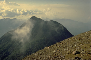 The summit of the sharp-peaked 1584-m Lewotobi Lakilaki is seen from its twin volcano located only 2 km to the SE, Lewotobi Perempuan. Lewotobi Lakilaki is the most active volcano on Flores Island, with frequent explosive eruptions in the 19th and 20th centuries. A 1932-33 eruption was accompanied by lava dome formation and pyroclastic flows.
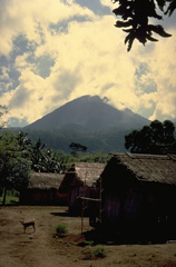 The Lewotobi "Husband and Wife" twin volcano is composed of the Lewotobi Lakilaki (seen in this view) and Lewotobi Perempuan stratovolcanoes, whose summits are less than 2 km apart on a NW-SE line. The summits of both volcanoes contain lava domes. Lewotobi Perempuan has had historical eruptions only in 1921 and 1935, whereas Lewotobi Lakilaki is one of the most active volcanoes on Flores Island, with frequent eruptions in the 19th and 20th centuries.
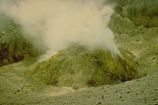 A sulfur-encrusted, steaming lava dome in the summit crater of Lewotobi Perempuan volcano (seen here in 1971) was formed during an eruption from January 1 to December 1921. The only other historical eruption of Lewotobi Perampuan was in 1935, although its twin volcano to the SE, Lewotobi Lakilaki, is one of the most active volcanoes on Flores Island, with frequent eruptions in the 19th and 20th centuries.
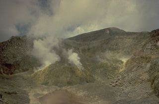 The summit crater of Lewotobi Perempuan, the SE of the two adjacent Lewotobi stratovolcanoes, contains a steaming lava dome that formed during an eruption in 1921. Solfataric activity has been observed here since the first report in 1821, although its only other eruption was in 1935.
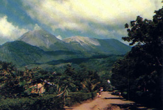 Lewotobi Lakilaki (left) and Lewotobi Perempuan (right) rise above a village on their western flanks. Both the conical Lakilaki and the broad Perempuan volcanoes have erupted during historical time.
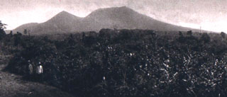 The peaks of Gunung Lewotobi have differing profiles, seen here from the SW. The summit of sharp-peaked Lewotobi Lakilaki (left) lies only 2 km NW of the broader summit of Lewotobi Perempuan. Both volcanoes have erupted during historical time.
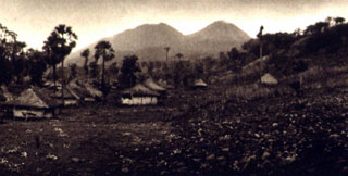 The NE flanks of Gunung Lewotobi rise above the village of Nobo. Lewotobi Perempuan (left) is located SW of Lewotobi Lakilaki (right). Both of these volcanoes have erupted during historical time, although Lakilaki has erupted much more frequently.
 The first historical eruption of Lewotobi Perempuan took place in 1921, when explosive eruptions and lava dome growth were reported in January, May, and December. A gas-and-steam plume rises above the dome in this 1920's view from the NE. The 35-m-high lava dome was emplaced on the floor of crater B, the innermost of two craters at the summit.
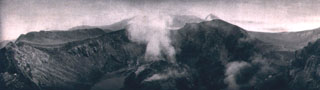 The lava dome emplaced in 1921 on the floor of the summit crater of Lewotobi Perempuan is seen from the NW crater rim in 1925. The 35-m-high dome was formed during the first of two historical eruptions. In contrast, Lewotobi Lakilaki, has erupted frequently since the 19th century.
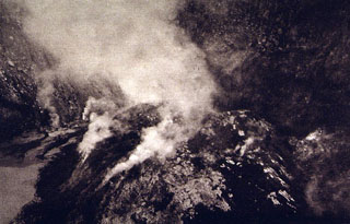 A plume rises above a lava dome emplaced in the summit crater of Lewotobi Perempuan volcano in 1921. The 90-130 m wide, 35-m-high lava dome is seen here from the NW crater rim.
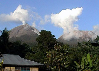 Lewotobi Lakilaki (left) and Lewotobi Perempuan (right) rise above forests on their western flanks. They were constructed along a NW-SE-trending line. Both volcanoes have erupted during historical time but Lakilaki has been more active.
The maps shown below have been scanned from the GVP map archives and include the volcano on this page. Clicking on the small images will load the full 300 dpi map. Very small-scale maps (such as world maps) are not included. The maps database originated over 30 years ago, but was only recently updated and connected to our main database. We welcome users to tell us if they see incorrect information or other problems with the maps; please use the Contact GVP link at the bottom of the page to send us email.
There are no samples for Lewotobi in the Smithsonian's NMNH Department of Mineral Sciences Rock and Ore collection.
| Copernicus Browser | The Copernicus Browser replaced the Sentinel Hub Playground browser in 2023, to provide access to Earth observation archives from the Copernicus Data Space Ecosystem, the main distribution platform for data from the EU Copernicus missions. |
| MIROVA | Middle InfraRed Observation of Volcanic Activity (MIROVA) is a near real time volcanic hot-spot detection system based on the analysis of MODIS (Moderate Resolution Imaging Spectroradiometer) data. In particular, MIROVA uses the Middle InfraRed Radiation (MIR), measured over target volcanoes, in order to detect, locate and measure the heat radiation sourced from volcanic activity. |
| MODVOLC Thermal Alerts | Using infrared satellite Moderate Resolution Imaging Spectroradiometer (MODIS) data, scientists at the Hawai'i Institute of Geophysics and Planetology, University of Hawai'i, developed an automated system called MODVOLC to map thermal hot-spots in near real time. For each MODIS image, the algorithm automatically scans each 1 km pixel within it to check for high-temperature hot-spots. When one is found the date, time, location, and intensity are recorded. MODIS looks at every square km of the Earth every 48 hours, once during the day and once during the night, and the presence of two MODIS sensors in space allows at least four hot-spot observations every two days. Each day updated global maps are compiled to display the locations of all hot spots detected in the previous 24 hours. There is a drop-down list with volcano names which allow users to 'zoom-in' and examine the distribution of hot-spots at a variety of spatial scales. |
|
WOVOdat
Single Volcano View Temporal Evolution of Unrest Side by Side Volcanoes |
WOVOdat is a database of volcanic unrest; instrumentally and visually recorded changes in seismicity, ground deformation, gas emission, and other parameters from their normal baselines. It is sponsored by the World Organization of Volcano Observatories (WOVO) and presently hosted at the Earth Observatory of Singapore.
GVMID Data on Volcano Monitoring Infrastructure The Global Volcano Monitoring Infrastructure Database GVMID, is aimed at documenting and improving capabilities of volcano monitoring from the ground and space. GVMID should provide a snapshot and baseline view of the techniques and instrumentation that are in place at various volcanoes, which can be use by volcano observatories as reference to setup new monitoring system or improving networks at a specific volcano. These data will allow identification of what monitoring gaps exist, which can be then targeted by remote sensing infrastructure and future instrument deployments. |
| Volcanic Hazard Maps | The IAVCEI Commission on Volcanic Hazards and Risk has a Volcanic Hazard Maps database designed to serve as a resource for hazard mappers (or other interested parties) to explore how common issues in hazard map development have been addressed at different volcanoes, in different countries, for different hazards, and for different intended audiences. In addition to the comprehensive, searchable Volcanic Hazard Maps Database, this website contains information about diversity of volcanic hazard maps, illustrated using examples from the database. This site is for educational purposes related to volcanic hazard maps. Hazard maps found on this website should not be used for emergency purposes. For the most recent, official hazard map for a particular volcano, please seek out the proper institutional authorities on the matter. |
| IRIS seismic stations/networks | Incorporated Research Institutions for Seismology (IRIS) Data Services map showing the location of seismic stations from all available networks (permanent or temporary) within a radius of 0.18° (about 20 km at mid-latitudes) from the given location of Lewotobi. Users can customize a variety of filters and options in the left panel. Note that if there are no stations are known the map will default to show the entire world with a "No data matched request" error notice. |
| UNAVCO GPS/GNSS stations | Geodetic Data Services map from UNAVCO showing the location of GPS/GNSS stations from all available networks (permanent or temporary) within a radius of 20 km from the given location of Lewotobi. Users can customize the data search based on station or network names, location, and time window. Requires Adobe Flash Player. |
| DECADE Data | The DECADE portal, still in the developmental stage, serves as an example of the proposed interoperability between The Smithsonian Institution's Global Volcanism Program, the Mapping Gas Emissions (MaGa) Database, and the EarthChem Geochemical Portal. The Deep Earth Carbon Degassing (DECADE) initiative seeks to use new and established technologies to determine accurate global fluxes of volcanic CO2 to the atmosphere, but installing CO2 monitoring networks on 20 of the world's 150 most actively degassing volcanoes. The group uses related laboratory-based studies (direct gas sampling and analysis, melt inclusions) to provide new data for direct degassing of deep earth carbon to the atmosphere. |
| Large Eruptions of Lewotobi | Information about large Quaternary eruptions (VEI >= 4) is cataloged in the Large Magnitude Explosive Volcanic Eruptions (LaMEVE) database of the Volcano Global Risk Identification and Analysis Project (VOGRIPA). |
| EarthChem | EarthChem develops and maintains databases, software, and services that support the preservation, discovery, access and analysis of geochemical data, and facilitate their integration with the broad array of other available earth science parameters. EarthChem is operated by a joint team of disciplinary scientists, data scientists, data managers and information technology developers who are part of the NSF-funded data facility Integrated Earth Data Applications (IEDA). IEDA is a collaborative effort of EarthChem and the Marine Geoscience Data System (MGDS). |

