
According to the Tokyo VAAC a pilot observed an ash plume from Tori-shima drifting at an altitude of 2.1 km (7,000 ft) a.s.l. on 6 July.
Source: Tokyo Volcanic Ash Advisory Center (VAAC)
Uncertain ash plume reported by a pilot on 6 July 2013
Vigorous ash plumes from Izu-Torishima (also Torishima) were noted during mid-August 2002 that reached an approximate altitude of 1.2-1.5 km (BGVN 27:07 and 27:10). The volcano apparently remained quiet until 6 July 2013, when a pilot observed an ash plume drifting about 74 km N of the volcano at an altitude of 2.1 km. However, the Tokyo Volcanic Ash Advisory Center did not detect ash in satellite images. The Japan Meteorological Agency (JMA) has no information about this uncertain activity available online.
According to a news account quoting the JMA, a M 6.7 earthquake occurred near Izu-Torishima around 21 April 2013, but there is no evidence this event triggered any explosion.
Information Contacts: Tokyo Volcanic Ash Advisory Center (VAAC), Tokyo, Japan (URL: http://ds.data.jma.go.jp/svd/vaac/data/); Japan Meteorological Agency (JMA), Otemachi, 1-3-4, Chiyoda-ku Tokyo 100-8122, Japan (URL: http://www.jma.go.jp/).
According to the Tokyo VAAC a pilot observed an ash plume from Tori-shima drifting at an altitude of 2.1 km (7,000 ft) a.s.l. on 6 July.
Source: Tokyo Volcanic Ash Advisory Center (VAAC)
An eruption began at Tori-shima on 11 August and an aerial inspection by the Japan Coast Guard on 21 August revealed that "smoke" was no longer rising from the volcano as it had been on the 14th. Weak steaming was visible in the southern part of the crater. In addition, the sea surface around the island was faintly discolored.
Source: Japan Meteorological Agency (JMA) via the Volcano Research Center
The eruption that began at Tori-shima on 11 August continued until at least noon on the 14th. Eruption clouds reached ~1.2 km a.s.l. on the 13th and ~1 km a.s.l. on the 14th. During observations on the 14th, scientists found smoke was being emitted from three areas on the western inner wall of the summit crater. They also found that the crater seemed to have widened during the eruption and the sea surface was no longer discolored.
Source: Japan Meteorological Agency (JMA) via the Volcano Research Center
On 11 August around 1530 a ship sailing near Tori-shima reported to the Japan Coast Guard that they observed white smoke rising from the summit of the volcano. JMA reported that an aerial inspection the following day during 1145-1245 revealed an ash-laden plume rising from the SW crater wall of the summit crater (Iwoyama) and white plumes emanating from the S to SE portion of the crater wall. Vigorous ash plumes rose 200-300 m above the crater every few minutes, drifted W, and ultimately reached a height of 1 km a.s.l. The summit area and the middle slope NNW of the summit were covered with ash-fall deposits. Discolored sea water extended 20 km W of the island. Tori-shima is not inhabited by humans, but an endangered albatross species lives there.
Sources: Reuters; NOAA Marine Forecasts; Associated Press; Japan Meteorological Agency (JMA) via the Volcano Research Center
Reports are organized chronologically and indexed below by Month/Year (Publication Volume:Number), and include a one-line summary. Click on the index link or scroll down to read the reports.
Possible submarine eruption in October 1975
[A table of possible submarine eruptions based on aerial observations of water discoloration by the Japanese Maritime Safety Agency included an entry for 30.38°N, 140.32°E, in October 1975. This location is ~11 km S of Tori-shima.]
Information Contacts: AFP; U.S. Defense Mapping Agency.
Ash plumes during August 2002 indicate first activity since 1975
Around 1530 on 11 August 2002, a ship sailing near Tori-shima reported white smoke rising from the summit of the island. The Japanese Coast Guard inspected the island from the air during 1738-1818 and confirmed that the plume was rising 200-300 m from near the summit crater (Iwo-yama).
During an overflight on 12 August from 1145 to 1245 by the Japanese Meteorological Agency (JMA), an ash-laden plume was rising from the SW wall of the Iwo-yama summit crater. White plumes were also observed rising from the S to SE crater wall (figures 1 and 2). A vigorous ash plume rose 200-300 m above the crater every few minutes and drifted W to ~1 km above sea level. The summit area and the middle slope NNW of the summit were covered with ashfall deposits. The sea surface was discolored in an area up to 20 km W of the island. Izu-Tori-shima island is currently uninhabited.
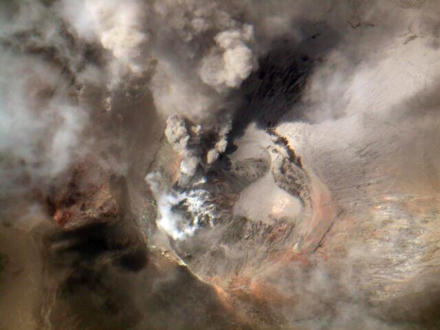 |
Figure 1. Photo showing the Iwo-yama crater of Tori-shima volcano, taken around 1200 on 12 August 2002. Courtesy JMA. |
 |
Figure 2. Southern view of Tori-shima volcano showing ash plume from the summit crater, taken around 1200 on 12 August 2002. Courtesy JMA. |
Information Contacts: Tomonori Kannno and Hitoshi Yamasato, Japanese Meteorological Agency (JMA), Volcanological Division, 1-3-4 Ote-machi, Chiyoda-ku, Tokyo 100, Japan (URL: http://www.jma.go.jp/).
Mid-August 2002 plumes, larger crater, and discolored water
Following ship-based reports of activity at Tori-shima on 11 August 2002, scientists from the Japanese Meterological Agency overflew the area the next day when they observed and photographed ash plumes being erupted from the crater (BGVN 27:07). According to the Japan Coast Guard (via JMA), the activity continued as of 1200 on 14 August; the plume reached ~1.2-1.5 km above sea level on 13 August (figure 3), and ~900 m on 14 August. Emissions were observed from three active areas along the western inner-wall of the summit crater. The crater appeared to have widened. By 21 August, the Japan Coast Guard reported that Izu-Tori-shima no longer "smoked" and only weak steaming was seen in the southern portion of the crater. Faintly discolored sea surface was observed around the island.
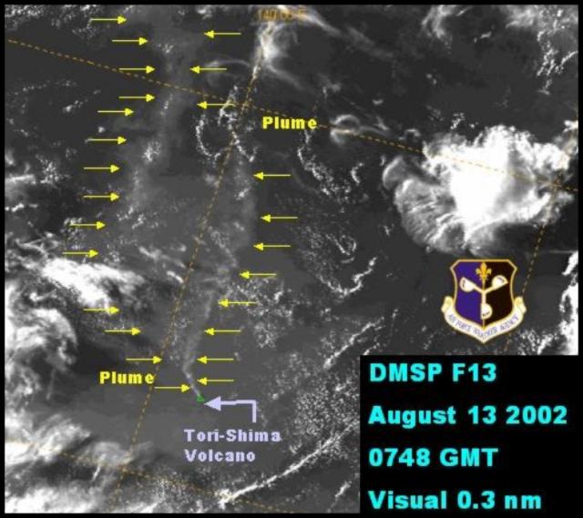 |
Figure 3. Izu-Tori-Shima plume on 13 August 2002. Courtesy Air Force Weather Agency. |
Information Contacts: Tomonori Kannno and Hitoshi Yamasato, Japanese Meteorological Agency (JMA), Volcanological Division, 1-3-4 Ote-machi, Chiyoda-ku, Tokyo 100, Japan (URL: http://www.jma.go.jp/); Volcano Research Center (VRC), Earthquake Research Institute (ERI), University of Tokyo (URL: http://www.eri.u-tokyo.ac.jp/VRC/index_E.html); U.S. Air Force Weather Agency, Offutt AFB, NE 68113-4039, USA.
Uncertain ash plume reported by a pilot on 6 July 2013
Vigorous ash plumes from Izu-Torishima (also Torishima) were noted during mid-August 2002 that reached an approximate altitude of 1.2-1.5 km (BGVN 27:07 and 27:10). The volcano apparently remained quiet until 6 July 2013, when a pilot observed an ash plume drifting about 74 km N of the volcano at an altitude of 2.1 km. However, the Tokyo Volcanic Ash Advisory Center did not detect ash in satellite images. The Japan Meteorological Agency (JMA) has no information about this uncertain activity available online.
According to a news account quoting the JMA, a M 6.7 earthquake occurred near Izu-Torishima around 21 April 2013, but there is no evidence this event triggered any explosion.
Information Contacts: Tokyo Volcanic Ash Advisory Center (VAAC), Tokyo, Japan (URL: http://ds.data.jma.go.jp/svd/vaac/data/); Japan Meteorological Agency (JMA), Otemachi, 1-3-4, Chiyoda-ku Tokyo 100-8122, Japan (URL: http://www.jma.go.jp/).
This compilation of synonyms and subsidiary features may not be comprehensive. Features are organized into four major categories: Cones, Craters, Domes, and Thermal Features. Synonyms of features appear indented below the primary name. In some cases additional feature type, elevation, or location details are provided.
Synonyms |
||||
| Tori-sima | Mitsugo-jima | Ponafidin | Izu-Tori-shima | Mitugo-zima | ||||
Cones |
||||
| Feature Name | Feature Type | Elevation | Latitude | Longitude |
|
Ioyama
Iwo-yama |
Cone | 394 m | 30° 28' 48" N | 140° 18' 22" E |
|
Komochi-yama
Komoti-yama |
Cone | 361 m | ||
Craters |
||||
| Feature Name | Feature Type | Elevation | Latitude | Longitude |
| Hyogowan | Crater | |||
|
|
||||||||||||||||||||||||
There is data available for 6 confirmed Holocene eruptive periods.
[ 2013 Jul 6 - 2013 Jul 6 ] Uncertain Eruption
| Episode 1 | Eruption Episode | ||||||||||||||||||||
|---|---|---|---|---|---|---|---|---|---|---|---|---|---|---|---|---|---|---|---|---|
| 2013 Jul 6 - 2013 Jul 6 | Evidence from Observations: Reported | |||||||||||||||||||
|
List of 2 Events for Episode 1
| ||||||||||||||||||||
2002 Aug 12 - 2002 Aug 20 Confirmed Eruption Max VEI: 2
| Episode 1 | Eruption Episode | Iwo-yama | ||||||||||||||||||||||||
|---|---|---|---|---|---|---|---|---|---|---|---|---|---|---|---|---|---|---|---|---|---|---|---|---|---|
| 2002 Aug 12 - 2002 Aug 20 | Evidence from Observations: Reported | ||||||||||||||||||||||||
|
List of 3 Events for Episode 1 at Iwo-yama
| |||||||||||||||||||||||||
1975 Oct 2 Confirmed Eruption Max VEI: 2
| Episode 1 | Eruption Episode | 9 km S of Torishima | |||||||||||||||||||
|---|---|---|---|---|---|---|---|---|---|---|---|---|---|---|---|---|---|---|---|---|
| 1975 Oct 2 - Unknown | Evidence from Observations: Reported | |||||||||||||||||||
|
List of 2 Events for Episode 1 at 9 km S of Torishima
| ||||||||||||||||||||
1965 Nov 13 - 1965 Dec 5 ± 4 days Confirmed Eruption Max VEI: 0
| Episode 1 | Eruption Episode | ||||||||||||||||||||
|---|---|---|---|---|---|---|---|---|---|---|---|---|---|---|---|---|---|---|---|---|
| 1965 Nov 13 - 1965 Dec 5 ± 4 days | Evidence from Observations: Hydrophonic | |||||||||||||||||||
|
List of 2 Events for Episode 1
| ||||||||||||||||||||
1939 Aug 17 - 1939 Dec 26 ± 5 days Confirmed Eruption Max VEI: 3
| Episode 1 | Eruption Episode | North side of 1902 crater (Iwo-yama) | |||||||||||||||||||||||||||||||||||||||
|---|---|---|---|---|---|---|---|---|---|---|---|---|---|---|---|---|---|---|---|---|---|---|---|---|---|---|---|---|---|---|---|---|---|---|---|---|---|---|---|---|
| 1939 Aug 17 - 1939 Dec 26 ± 5 days | Evidence from Observations: Reported | |||||||||||||||||||||||||||||||||||||||
|
List of 6 Events for Episode 1 at North side of 1902 crater (Iwo-yama)
| ||||||||||||||||||||||||||||||||||||||||
1902 Aug 7 - 1902 Aug 24 Confirmed Eruption Max VEI: 3
| Episode 1 | Eruption Episode | Komochi-yama, N & SW offshore flanks | |||||||||||||||||||||||||||||||||||||||
|---|---|---|---|---|---|---|---|---|---|---|---|---|---|---|---|---|---|---|---|---|---|---|---|---|---|---|---|---|---|---|---|---|---|---|---|---|---|---|---|---|
| 1902 Aug 7 - 1902 Aug 24 | Evidence from Observations: Reported | |||||||||||||||||||||||||||||||||||||||
|
List of 6 Events for Episode 1 at Komochi-yama, N & SW offshore flanks
| ||||||||||||||||||||||||||||||||||||||||
1871 Apr Confirmed Eruption Max VEI: 0
| Episode 1 | Eruption Episode | |||||||||||||||
|---|---|---|---|---|---|---|---|---|---|---|---|---|---|---|---|
| 1871 Apr - Unknown | Evidence from Observations: Reported | ||||||||||||||
|
List of 1 Events for Episode 1
| |||||||||||||||
There is no Deformation History data available for Izu-Torishima.
There is no Emissions History data available for Izu-Torishima.
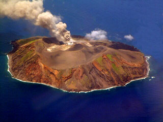 This photo taken on 12 August 2002 shows an ash plume rising from Torishima volcano, a 2.7-km-wide island in the southern Izu Islands. The unvegetated Iwoyama cone, seen here from the south, was constructed during an eruption in 1939 within a 1.5-km-wide caldera. The volcano is also referred to as Izu-Torishima to distinguish it from the several other Japanese island volcanoes called Torishima ("Bird Island").
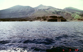 The dark-colored lava flow along the coast in the foreground was emplaced during an eruption that began on 17 August 1939. A new scoria cone (Iwoyama) was constructed in that year at the northern end of the 1902 crater. Two lava flows reached the sea, the first at Hyogowan (the bay to the far right) and the second at Chitose Bay. Two people were killed during the eruption, which ceased at the end of December.
The maps shown below have been scanned from the GVP map archives and include the volcano on this page. Clicking on the small images will load the full 300 dpi map. Very small-scale maps (such as world maps) are not included. The maps database originated over 30 years ago, but was only recently updated and connected to our main database. We welcome users to tell us if they see incorrect information or other problems with the maps; please use the Contact GVP link at the bottom of the page to send us email.
The following 1 samples associated with this volcano can be found in the Smithsonian's NMNH Department of Mineral Sciences collections, and may be availble for research (contact the Rock and Ore Collections Manager). Catalog number links will open a window with more information.
| Catalog Number | Sample Description | Lava Source | Collection Date |
|---|---|---|---|
| NMNH 107433-00 | Cristobalite | -- | -- |
| Copernicus Browser | The Copernicus Browser replaced the Sentinel Hub Playground browser in 2023, to provide access to Earth observation archives from the Copernicus Data Space Ecosystem, the main distribution platform for data from the EU Copernicus missions. |
| MIROVA | Middle InfraRed Observation of Volcanic Activity (MIROVA) is a near real time volcanic hot-spot detection system based on the analysis of MODIS (Moderate Resolution Imaging Spectroradiometer) data. In particular, MIROVA uses the Middle InfraRed Radiation (MIR), measured over target volcanoes, in order to detect, locate and measure the heat radiation sourced from volcanic activity. |
| MODVOLC Thermal Alerts | Using infrared satellite Moderate Resolution Imaging Spectroradiometer (MODIS) data, scientists at the Hawai'i Institute of Geophysics and Planetology, University of Hawai'i, developed an automated system called MODVOLC to map thermal hot-spots in near real time. For each MODIS image, the algorithm automatically scans each 1 km pixel within it to check for high-temperature hot-spots. When one is found the date, time, location, and intensity are recorded. MODIS looks at every square km of the Earth every 48 hours, once during the day and once during the night, and the presence of two MODIS sensors in space allows at least four hot-spot observations every two days. Each day updated global maps are compiled to display the locations of all hot spots detected in the previous 24 hours. There is a drop-down list with volcano names which allow users to 'zoom-in' and examine the distribution of hot-spots at a variety of spatial scales. |
|
WOVOdat
Single Volcano View Temporal Evolution of Unrest Side by Side Volcanoes |
WOVOdat is a database of volcanic unrest; instrumentally and visually recorded changes in seismicity, ground deformation, gas emission, and other parameters from their normal baselines. It is sponsored by the World Organization of Volcano Observatories (WOVO) and presently hosted at the Earth Observatory of Singapore.
GVMID Data on Volcano Monitoring Infrastructure The Global Volcano Monitoring Infrastructure Database GVMID, is aimed at documenting and improving capabilities of volcano monitoring from the ground and space. GVMID should provide a snapshot and baseline view of the techniques and instrumentation that are in place at various volcanoes, which can be use by volcano observatories as reference to setup new monitoring system or improving networks at a specific volcano. These data will allow identification of what monitoring gaps exist, which can be then targeted by remote sensing infrastructure and future instrument deployments. |
| Volcanic Hazard Maps | The IAVCEI Commission on Volcanic Hazards and Risk has a Volcanic Hazard Maps database designed to serve as a resource for hazard mappers (or other interested parties) to explore how common issues in hazard map development have been addressed at different volcanoes, in different countries, for different hazards, and for different intended audiences. In addition to the comprehensive, searchable Volcanic Hazard Maps Database, this website contains information about diversity of volcanic hazard maps, illustrated using examples from the database. This site is for educational purposes related to volcanic hazard maps. Hazard maps found on this website should not be used for emergency purposes. For the most recent, official hazard map for a particular volcano, please seek out the proper institutional authorities on the matter. |
| IRIS seismic stations/networks | Incorporated Research Institutions for Seismology (IRIS) Data Services map showing the location of seismic stations from all available networks (permanent or temporary) within a radius of 0.18° (about 20 km at mid-latitudes) from the given location of Izu-Torishima. Users can customize a variety of filters and options in the left panel. Note that if there are no stations are known the map will default to show the entire world with a "No data matched request" error notice. |
| UNAVCO GPS/GNSS stations | Geodetic Data Services map from UNAVCO showing the location of GPS/GNSS stations from all available networks (permanent or temporary) within a radius of 20 km from the given location of Izu-Torishima. Users can customize the data search based on station or network names, location, and time window. Requires Adobe Flash Player. |
| DECADE Data | The DECADE portal, still in the developmental stage, serves as an example of the proposed interoperability between The Smithsonian Institution's Global Volcanism Program, the Mapping Gas Emissions (MaGa) Database, and the EarthChem Geochemical Portal. The Deep Earth Carbon Degassing (DECADE) initiative seeks to use new and established technologies to determine accurate global fluxes of volcanic CO2 to the atmosphere, but installing CO2 monitoring networks on 20 of the world's 150 most actively degassing volcanoes. The group uses related laboratory-based studies (direct gas sampling and analysis, melt inclusions) to provide new data for direct degassing of deep earth carbon to the atmosphere. |
| Large Eruptions of Izu-Torishima | Information about large Quaternary eruptions (VEI >= 4) is cataloged in the Large Magnitude Explosive Volcanic Eruptions (LaMEVE) database of the Volcano Global Risk Identification and Analysis Project (VOGRIPA). |
| EarthChem | EarthChem develops and maintains databases, software, and services that support the preservation, discovery, access and analysis of geochemical data, and facilitate their integration with the broad array of other available earth science parameters. EarthChem is operated by a joint team of disciplinary scientists, data scientists, data managers and information technology developers who are part of the NSF-funded data facility Integrated Earth Data Applications (IEDA). IEDA is a collaborative effort of EarthChem and the Marine Geoscience Data System (MGDS). |

