
The Japan Coast Guard reported that during a 27 December overflight of Fukutoku-Oka-no-Ba, observers noted that the island formed in mid-August had become smaller since 14 December, and had almost eroded below the ocean surface. No eruptive activity was observed, though brownish water spouted from the E end of the island. Yellowish-green water and a string of floating pumice, 400 m long, was circulating 5 km E. Discolored water was visible around almost the entire coast of Minami-Ioto (5 km SSW).
Source: Japan Coast Guard
Surtseyan explosions, an ash plume, and floating pumice rafts during August 2021
Fukutoku-Oka-no-ba is a submarine volcano located 5 km NE of the Japanese island of Minami-Ioto, about 1,300 km S of Tokyo. Typical activity at the site has consisted of discolored water and floating pumice. An island (called “Shin-Ioto”) was present during 1904-1905 and 1914. The 1986 eruption also built an island 600 m long and 15 m high which was later eroded away, according to information from the Japan Coast Guard. An explosion above the water surface was observed on 3 February 2010, which continued into that April (BGVN 41:06). Intermittent observations of discolored water have been made since that time, but there has been no notable eruptive activity until strong explosions in mid-August 2021 sent ash plumes to altitudes of over 12 km. Observations and monthly and special information reports come from the Japan Meteorological Agency (JMA), Japan Coast Guard (JCG) and Japan Maritime Self Defense Force (JMSDF), as well as various satellite data.
Summary of activity during May 2014-July 2021. Between May 2014 and 6 March 2016, the Japan Coast Guard intermittently visited the site, though no reports of water discoloration were made (table 4). Beginning on 7 March 2016, a pale green discoloration was noted in the water, measuring 200 x 1,000 m. Similar variations of greenish discolored water continued intermittently leading up to the eruption on 13 August 2021.
Table 4. Summary of observations made at Fukutoku-Oka-no-Ba between October 2015 and December 2021 by Japanese authorities. The Japan Coast Guard continued to visit the site intermittently, noting occasional water discoloration. Sources: JMA = Monthly Summary Report, Japan Meteorological Agency, JMSDF = Japan Maritime Self Defense Force, TRCGH = Third Regional Coast Guard Headquarters, JCG = Japan Coast Guard.
| Visit Date | Discolored Water | Dimensions | Description | Source |
| 11 Jun 2014 | No | -- | -- | MSDF |
| 13 Jun 2014 | No | -- | -- | TRCGH |
| 25 Jun 2014 | No | -- | -- | JCG |
| 12 Sep 2014 | No | -- | -- | MSDF |
| 26 Nov 2014 | No | -- | -- | TRCGH |
| 26 Dec 2014 | No | -- | -- | MSDF |
| 27 Jan 2015 | No | -- | -- | TRCGH |
| 15 Feb 2015 | No | -- | -- | TRCGH |
| 18 Feb 2015 | No | -- | -- | TRCGH |
| 14 Apr 2015 | No | -- | -- | TRCGH |
| 05 May 2015 | No | -- | -- | TRCGH |
| 26 May 2015 | No | -- | -- | TRCGH |
| 17 Aug 2015 | No | -- | -- | JCG |
| 23 Aug 2015 | No | -- | -- | TRCGH |
| 18 Oct 2015 | No | -- | -- | TRCGH |
| 07 Mar 2016 | Yes | 200 x 1,000 m | Very pale green | TRCGH |
| 29 Mar 2016 | No | -- | -- | JCG |
| 24 Dec 2016 | No | -- | -- | JCG |
| 09 Feb 2017 | No | -- | -- | MSDF |
| 07 Mar 2017 | Yes | 500 m radius | Light green, four locations vent | JMSDF |
| 24 Mar 2017 | Yes | 50 x 1,000 m NE | Yellow-green | JCG |
| 30 Mar 2017 | Yes | 700 m diameter | Pale green | MSDF |
| 24 Apr 2017 | No | -- | -- | MSDF |
| 28 Jun 2017 | No | -- | -- | JCG |
| 03 Jul 2017 | No | -- | -- | MSDF |
| 06 Oct 2017 | No | -- | -- | MSDF |
| 11 Dec 2017 | Yes | 2 x 6 km | Pale green | JCG |
| 27 Jan 2018 | Yes | 600 m diameter | Yellow-green | MSDF |
| 24 Feb 2018 | Yes | 500 x 1,000 m | Light green | MSDF |
| 27 Apr 2018 | No | -- | -- | MSDF |
| 18 Jul 2018 | No | -- | -- | JCG |
| 29 Jan 2019 | Yes | 1 km diameter | Light green | JCG |
| 19 Nov 2019 | No | -- | -- | JCG |
| 04 Feb 2020 | Yes | -- | Whitish yellow-green drifting E | JCG |
| 15 Mar 2020 | Yes | -- | Bluish-white | JCG |
| 16 Apr 2020 | Yes | -- | Yellow-green | TRCGH |
| 19 Apr 2020 | Yes | -- | Bluish white drifting E | TRCGH |
| 18 May 2020 | No | -- | -- | TRCGH |
| 19 Jun 2020 | No | -- | -- | JCG |
| 05 Apr 2021 | Yes | -- | Pale blue | JCG |
| 08 Jun 2021 | Yes | 2.4 km diameter N | Bluish-white | JCG |
| 09 Jul 2021 | Yes | -- | Bluish-white | JCG |
| 05 Aug 2021 | Yes | -- | Bluish-white drifted SSW | JCG |
| 13 Aug 2021 | -- | -- | Eruption began, though observations could not be made | TRCGH |
| 15 Aug 2021 | -- | 1 km diameter | New island with intermittent eruptions and floating pumice drifting 60 km NW | TRCGH |
| 16 Aug 2021 | Yes | -- | Gas-and-steam plume from the island, suspended pumice drifted 100 km WNW | JCG |
| 26 Aug 2021 | Yes | -- | Brown drifting W, suspended pumice | JCG |
| 12 Sep 2021 | Yes | 2 km diameter | Yellowish-green to yellowish-brown, second yellow-green discolored area 2 km ENE of the island | JCG |
| 12 Oct 2021 | Yes | -- | Brown and yellow-green drifting 5.6 km NW, white waves | JCG |
| 01 Nov 2021 | Yes | -- | Bluish-white | TRCGH |
| 11 Nov 2021 | Yes | 3 km diameter and 2 km diameter | Dark yellow-green and a second yellow-green with floating pumice | JCG |
| 29 Nov 2021 | Yes | -- | Brown to yellowish-green | TRCGH |
| 14 Dec 2021 | Yes | -- | Yellow-green and bluish-white | TRCGH |
| 27 Dec 2021 | Yes | -- | Brown and yellowish-green | JCG |
Observers on four overflights during 2020 reported visible discolored water originating from a single location, which has been frequently noted since 2005, according to JMA. On 4 February 2020 the Japan Coast Guard (JCG) conducted an overflight that confirmed pale white- to yellow-green discolored water on the ocean surface near the volcano over a distance of about 6.3 km to the W (figure 16). Discolored bluish-white water was again reported by JCG during an overflight on 15 March, though it was fainter than the previous observations. Similar faint discolored water was reported on 16 and 19 April by JCG. No further activity was reported for the rest of 2020. Similar activity was observed in overflights by JCG during the first half of 2021. Faintly discolored water (light blue to white) was observed during overflights on 5 April, 8 June, and 9 July (figure 17) according to JCG.
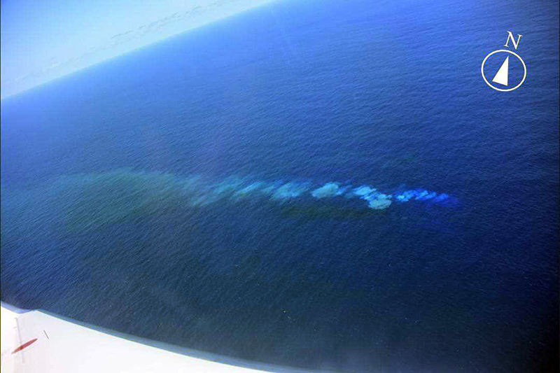 |
Figure 16. Photo of the white and yellow-green discolored water extending 6.3 km W from Fukutoku-Oka-no-Ba at 1351 on 4 February 2020. Courtesy of Japan Coast Guard and JMA (monthly report of activity at Fukutoku-Oka-no-Ba, February 2020). |
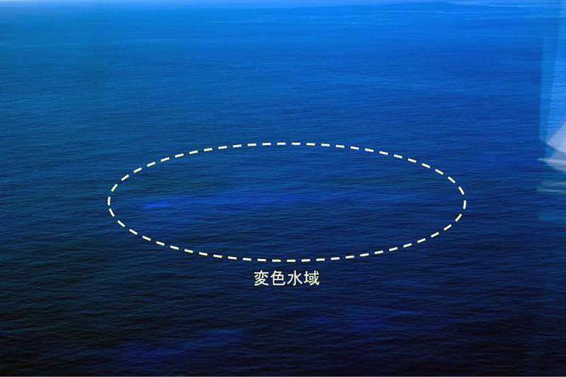 |
Figure 17. Photo of faintly white-blue discolored water (inside dashed circle) at Fukutoku-Oka-no-Ba at 1251 on 9 July 2021. Courtesy of Japan Coast Guard and JMA (monthly report of activity at Fukutoku-Oka-no-Ba, July 2021). |
Eruption during August 2021. During aerial observations on 5 August the JCG only saw a blue-white discolored area SSW of the volcano. A large eruption starting at 0620 on 13 August 2021 was reported by JCG, based on satellite data, and was later confirmed during an overflight that day. The resulting ash plume rose as high as 16 km altitude and had drifted 700-1,000 km W by 0900 (figure 18). Video data showed Surtseyan explosions that ejected black material above the ocean surface and drifted W. Ash plumes identified in satellite images rose 12.2-16 km altitude during 13-15 August (figure 19) and eventually reached the N part of Luzon Island in the Philippines (2,000 km SW); the height decreased after the initial ejection, though activity continued. During an overflight on 15 August the JCG observed a new island (also referred to as “Niijima”) that measured about 1 km in diameter, where gas-and-steam emissions were detected rising from its center on 16 August (figure 20). Brown discoloration of a variable shape, but with a consistent diameter of 1 km, was visible surrounding the new island. Additionally, a notable floating pumice raft was photographed extending up to 60-100 km WNW and was about 13 km wide (figure 21). A Sentinel-2 natural color satellite image captured the newly formed island, surrounded by yellow-green discolored water that extended E the next day on 17 August (figure 22).
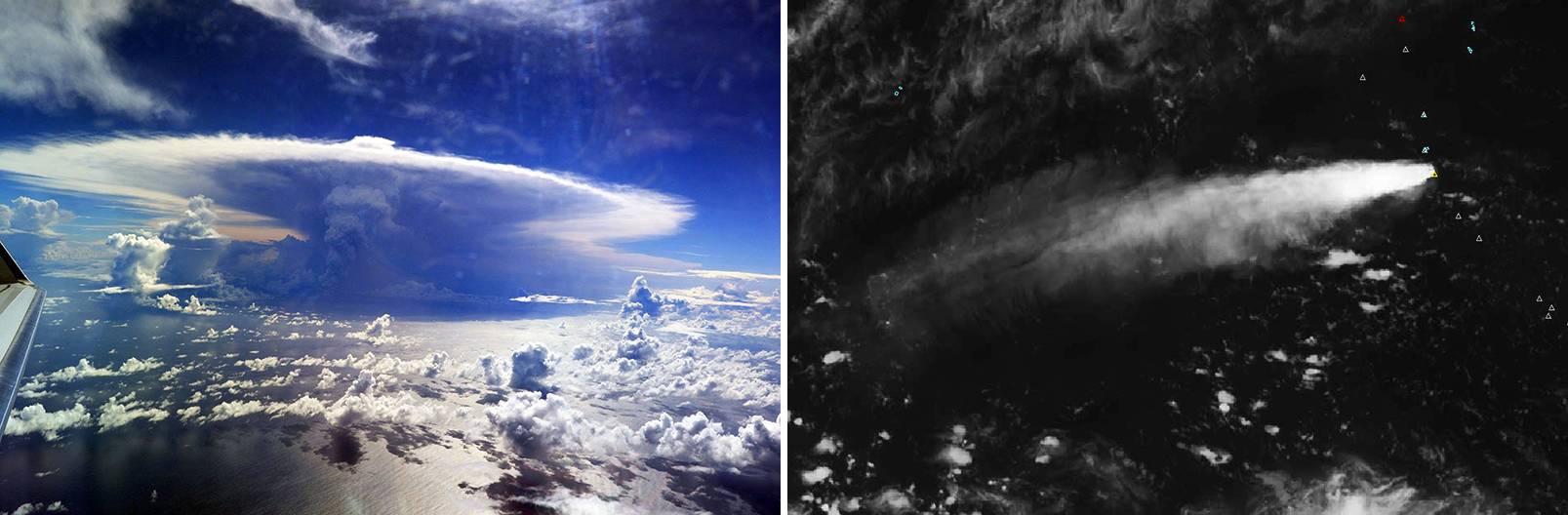 |
Figure 18. Photo of the eruption plume at Fukutoku-Oka-no-Ba taken 90 km N of the eruption site at 1452 on 13 August 2021 (left). The plume rose to 6 km altitude. HIMAWARI satellite image shows the extent of the plume that extended W at 2000 on 13 August 2021. It reached a maximum altitude of 16 km from 0900 on 13 August to 0300 on 15 August 2021 (right). Left photo by the Third Regional Coast Guard Headquarters; courtesy of Japan Coast Guard and JMA (monthly report of activity at Fukutoku-Oka-no-Ba, August 2021). |
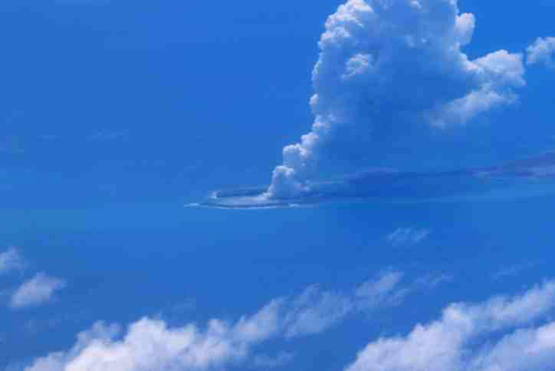 |
Figure 19. Photo of the plume rising above Fukutoku-Oka-no-Ba at 1256 on 15 August 2021 as floating pumice was observed drifting 60 km NW. Courtesy of Japan Coast Guard and JMA (monthly report of activity at Fukutoku-Oka-no-Ba, August 2021). |
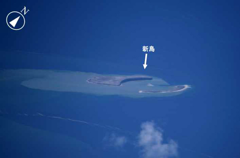 |
Figure 20. Photo of the new island that was visible on 16 August 2021 at Fukutoku-Oka-no-Ba surrounded by discolored brown-green water extending to the W. The diameter of the island is approximately 1 km. Courtesy of Japan Coast Guard and JMA (monthly report of activity at Fukutoku-Oka-no-Ba, August 2021). |
 |
Figure 21. Photo (color corrected) of the notable brown floating pumice raft from Fukutoku-Oka-no-Ba at 1508 on 16 August 2021. View is looking N with the pumice raft approximately 40 km NW of the volcano; Iwo-jima island (top right) is approximately 8 x 6 km, though it is distorted in this oblique aerial view, and located about 55 km NNW of Fukutoku-Oka-no-Ba. Courtesy of the Japan Coast Guard. |
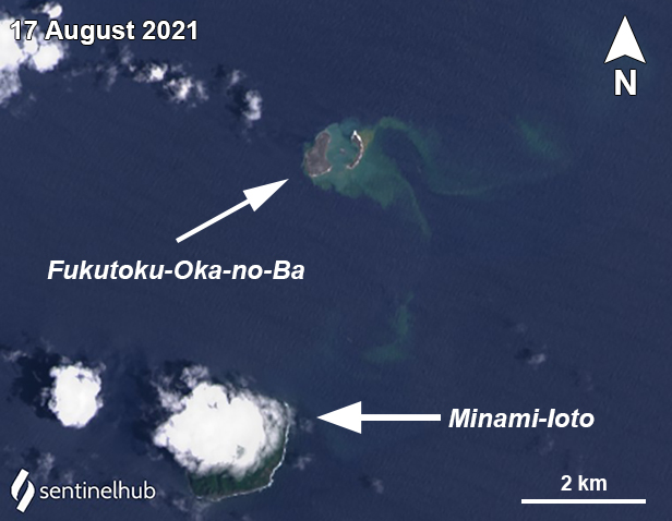 |
Figure 22. Landsat-8 satellite image showing the appearance of discolored water and the new island emergence about 1 km in diameter at Fukutoku-Oka-no-Ba. An area of light yellow-green discoloration extended in two tendrils to the E and SE. The island to the SW of Fukutoku-Oka-no-Ba is Minami-Ioto. Landsat-8 satellite images with “True Color” rendering. Courtesy of Sentinel Hub Playground. |
A local fisherman about 5 km SSW near South Iwo Jima (Minami-Ioto) posted photos from 17 (figure 23), 20, and 22 August showing a plume rising above the volcano. On 20 August lightning was visible within the plume. Another plume was observed during 0430-0630 on 22 August and some of the floating pumice was collected by the Ocean Meteorological Observation vessel, Keikaze Maru (figure 24). The largest sample was about 40 cm in diameter; samples were mainly white, gray, and dark gray with visible bubbles, which JMA reported was similar to the samples collected from the 1986 eruption. During an overflight on 26 August observers noted that while the W part of the island remained unchanged, the E side had mostly eroded, yielding two small islands (figure 25). Though no eruptive activity was visible, gray material from the central vent was intermittently ejected to the ocean surface, and brown discolored water remained widely distributed, extending especially to the W.
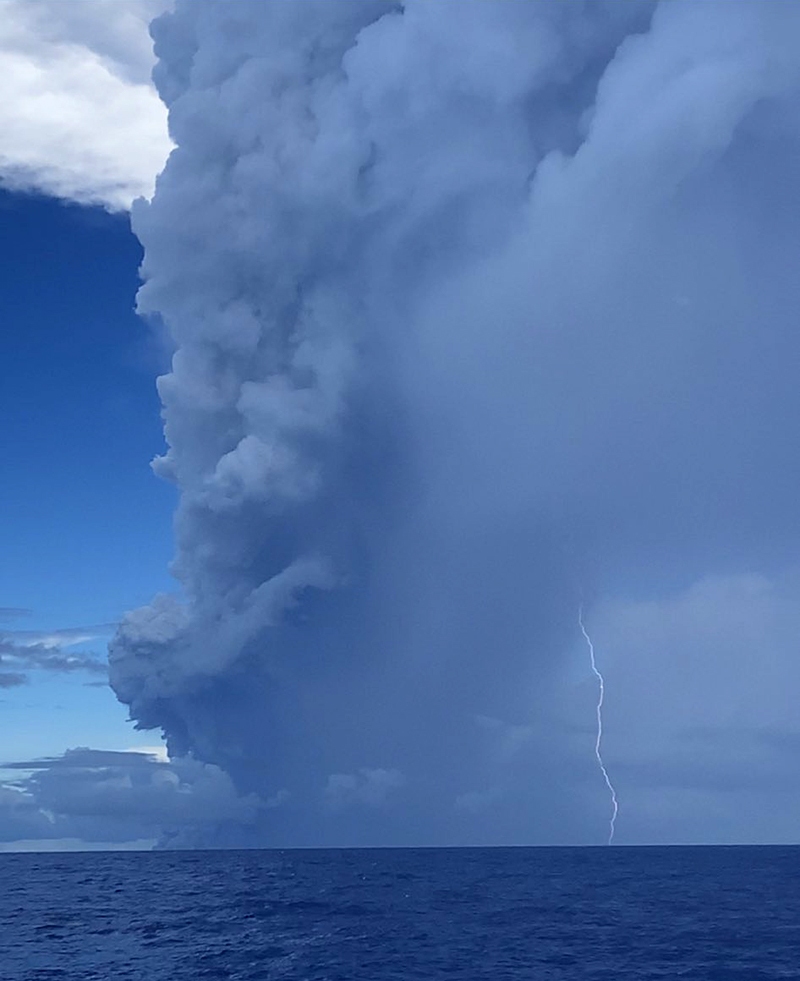 |
Figure 23. Photo of the plume rising above Fukutoku-Oka-no-Ba on 17 August 2021. Courtesy of Yutaka Kosugi. |
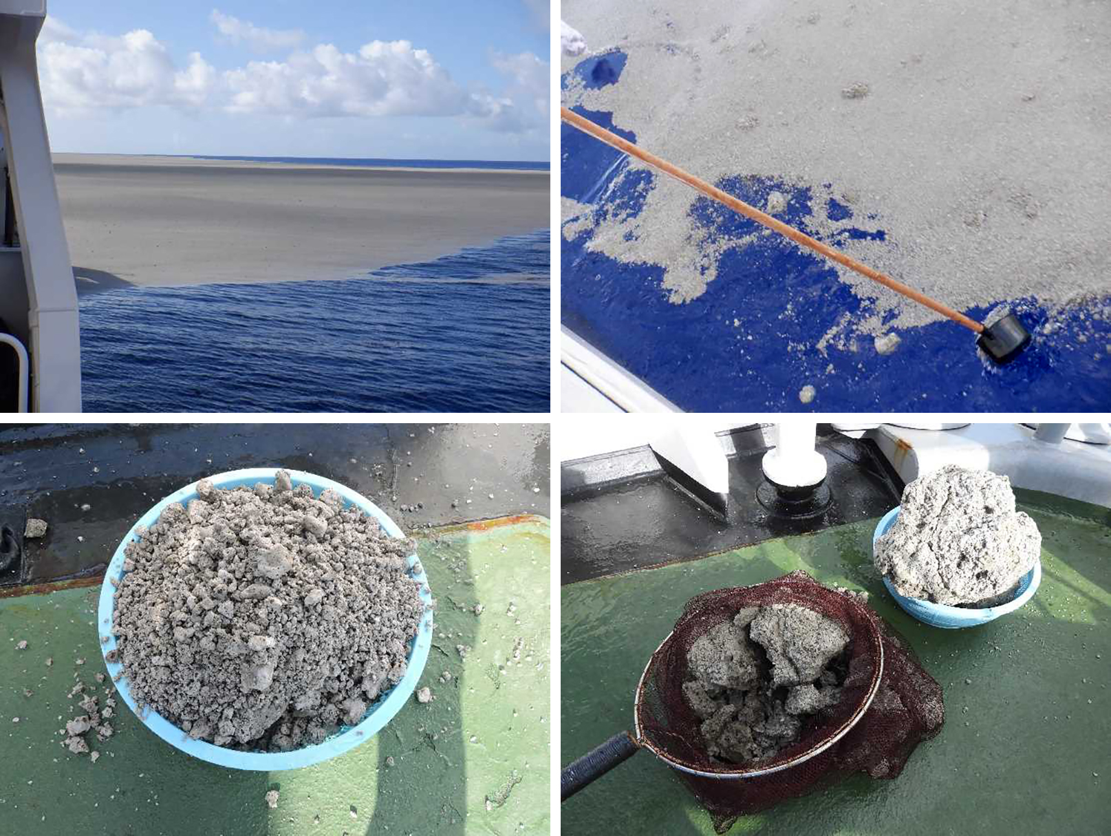 |
Figure 24. Photos of the floating pumice that was ejected from Fukutoku-Oka-no-Ba at 0745 on 22 August 2021, collected by the Ocean Meteorological Observation vessel Keifu Maru. The pumice (light gray) was observed floating on the surface of the water (top left), which was then collected at 0745 (top right). The samples were mainly white, gray, and dark gray, and varied in size (bottom left and right). Courtesy of JMA (monthly report of activity at Fukutoku-Oka-no-Ba, August 2021). |
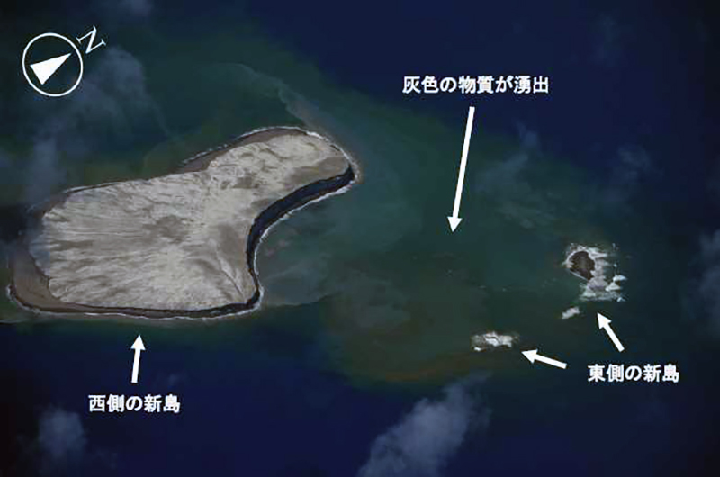 |
Figure 25. Photo of the new island at Fukutoku-Oka-no-Ba at 1307 on 26 August 2021 accompanied by some gray ejecta on the ocean surface. The east side of the island is partially submerged compared to initial observations made on 16 August. Yellow-green discolored water was widely observed to the W. Courtesy of Japan Coast Guard and JMA (monthly report of activity at Fukutoku-Oka-no-Ba, August 2021). |
Activity during September-December 2021. JMA reported that the yellow-green to yellow-brown discolored water continued to be widely distributed in the area during September. By 12 September an overflight showed that the E side of the island had been completely eroded and submerged (figure 26), while the length of the W side measured 1 km. Yellow-green to yellow-brown discolored water extended from the vent area to the SW, S, and SE. In addition, on 12 September an area of yellow-green to yellow-brown discolored water 2 km in diameter, independent of the initial eruption site, was observed 2 km ENE of the new island (figure 27). Floating pumice were also noted around the discolored area. As a result, JMA issued a navigation warning to nearby vessels.
 |
Figure 26. Aerial photo of the island that appeared at Fukutoku-Oka-no-Ba on 16 August; the E side has been eroding away while the length of the W side (pictured) is 1 km. Yellow-brown discolored water was widely distributed around the island. The island at top left is Minami-Ioto. Photo was taken on 12 September 2021. Courtesy of Japan Coast Guard and JMA (monthly report of activity at Fukutoku-Oka-no-Ba, September 2021). |
 |
Figure 27. Photo of the new 2-km-diameter area of yellow-brown discolored water (foreground) located 2 km ENE of Fukutoku-Oka-no-Ba (middle right) at 1304 on 12 September 2021. The island on the left is Minami-Ioto. Floating pumice was also noted surrounding the discolored water. Courtesy of Japan Coast Guard and JMA (monthly report of activity at Fukutoku-Oka-no-Ba, September 2021). |
Discolored water areas persisted into October, as well as floating pumice. By early October the JCG reported that the floating pumice that was ejected during the eruption in mid-August had reached the coastlines more than 1,000 km from the volcano. Pumice first reached Minamidaitou Island (1,000 km W) on 4 October (figure 28) and samples were collected and compared to those collected on 22 August. Pumice was later reported at Kitadaito Island (1,000 km W) during 5-8 October. Aerial observations reported that the W side of the new island had eroded to a third of the size it was when previously described on 12 September (figure 29). Brownish discolored water was distributed near the N shore of the W part of the island, accompanied by yellow-green discoloration, extending about 6 km NW of the volcano (figure 29). Later in the month, the pumice circled Okinawa and Maejima islands (1,400 km W) and several ports in the Kagoshima prefecture (1,300 km NW), which damaged hundreds of boats and ships, clogged harbors (figure 30), and impacted the fishing and tourism industries in several areas, which led local governments to begin removing the pumice from the water.
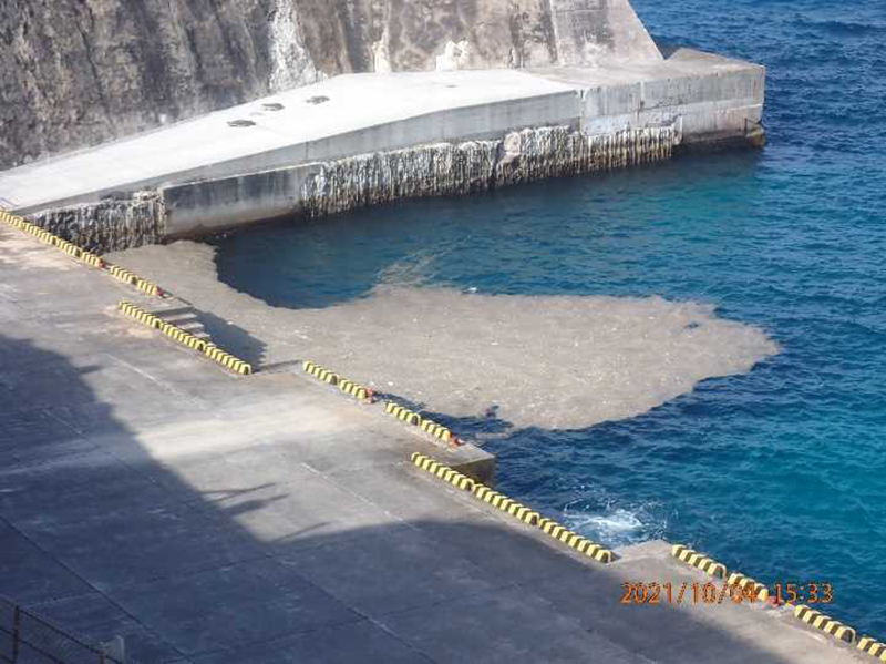 |
Figure 28. Photos of the floating pumice from the 13 August 2021 eruption at Fukutoku-Oka-no-Ba reaching the coast of Minamidaito Island (1,000 km W) on 4 October 2021 at 1533. Courtesy of the Minamidaito Island District Meteorological Observatory and JMA (monthly report of activity at Fukutoku-Oka-no-Ba, October 2021). |
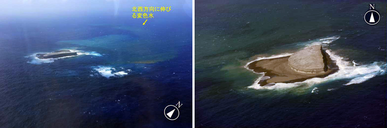 |
Figure 29. Aerial photos of the island that appeared at Fukutoku-Oka-no-Ba on 16 August; by 12 October the length of the W side of the island measured 500 m while the E side was completely submerged (left). Brownish discolored water and floating pumice surrounded the island, as well as yellow-green discoloration that extended about 6 km NW of the volcano (right). The left picture was taken at 1308 and the right picture was taken at 1313. Courtesy of Japan Coast Guard and JMA (monthly report of activity at Fukutoku-Oka-no-Ba, October 2021). |
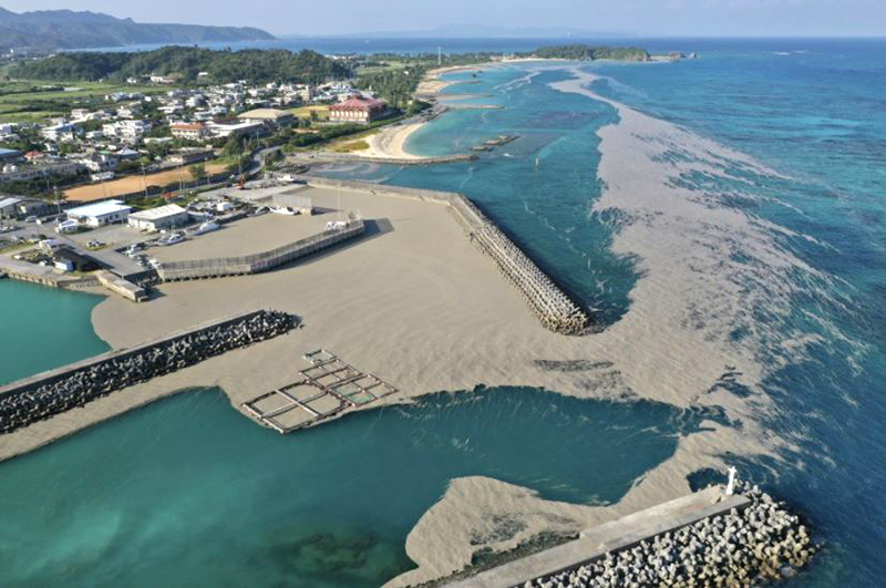 |
Figure 30. Photos of the floating pumice rafts from Fukutoku-Oka-no-Ba that reached the fishing port at Hentona, Kunigami (1,400 km W), a village located in the N part of Okinawa, on 29 October 2021. The length of this harbor is approximately 300 m. The distance between the harbor and the peninsula in the distance is approximately 2 km, where the pumice is seen extending along the coastline. Okinawa authorities began to remove the pumice with shovel loaders, as it was disrupting fishing and tourism. The pumice came ashore at 16 fishing ports in Okinawa and Kagoshima, damaging 40 boats. Courtesy of NHK Japan Broadcasting Corporation. |
During an overflight on 11 November white fumarolic plumes were observed rising from the N end of the island, accompanied by a blue-white band of discolored water in the S part of the island and a dark yellow-green band on the W side (figure 31). Circular discoloration was also observed on the N side of the island, along with bubbling that was seen on the ocean surface near the same location. On 27 December observers reported that the island that formed in mid-August had become smaller since 14 December and had almost eroded below the ocean surface. No eruptive activity was observed, though discolored brownish water was visible from the E end of the island. Yellow-green water and a 400-m-long string of floating pumice was circulating 5 km E of the volcano. Discolored water was visible surrounding almost the entire coast of Minami-Ioto (5 km SSW).
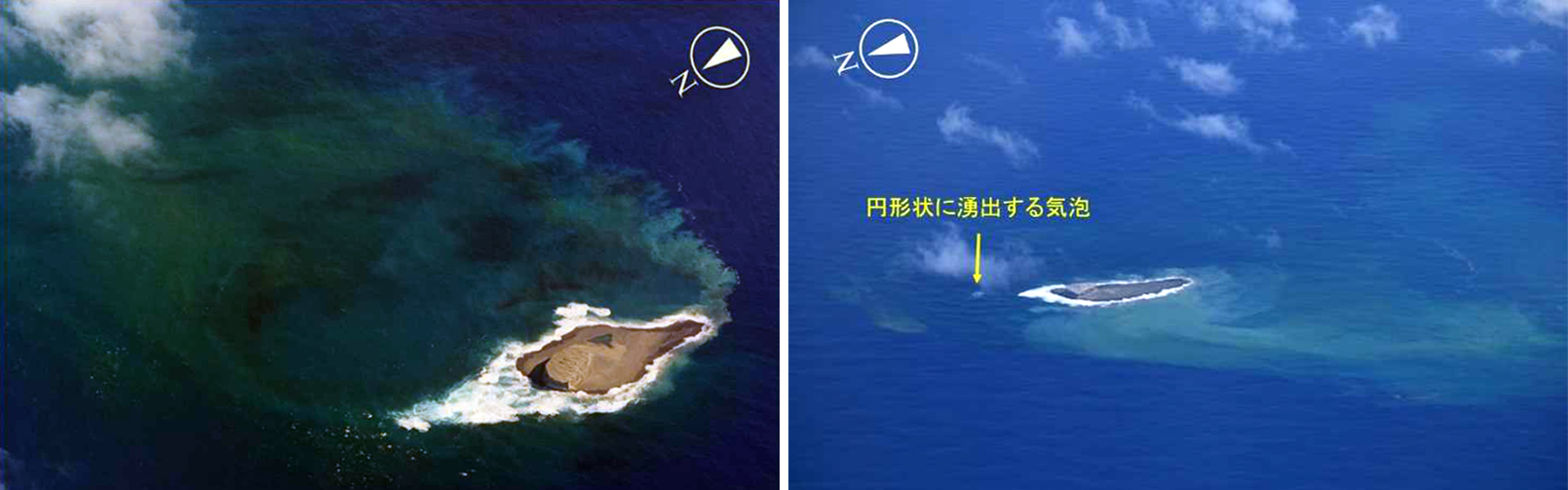 |
Figure 31. Aerial photos of Fukutoku-Oka-no-Ba showing white waves on the N end of the island accompanied by yellow-green discolored water on the W side of the island on 11 November 2021 at 1359 (left). A small circular bubble was observed on the ocean surface N of the island (yellow arrow). In addition, yellow-green discolored water with a diameter of about 2 km and floating pumice 20 km SE of the volcano at 1245 on 11 November was visible (right). Courtesy of Japan Coast Guard and JMA (monthly report of activity at Fukutoku-Oka-no-Ba, November 2021). |
During December the brown-yellow discoloration continued to spread around the island, which by 27 December had noticeably decreased in size since seen on 29 November. Blue-white discoloration expanded to the NNE. Brown discolored water was visible from the E side of the island as yellow-green discoloration was distributed 5 km E of the same location. On 27 December the island was covered with white waves and was surrounded by blue-green discolored water (figure 32).
 |
Figure 32. Photo of the August eruption site at Fukutoku-Oka-no-Ba covered by white waves and surrounded by blue-green discolored water at 1304 on 27 December 2021. Courtesy of Japan Coast Guard. |
Satellite data. Landsat-8 satellite images were used to track the occurrence and direction of the discolored water plumes originating at the volcano (figure 33). Discoloration was detected during February 2021 and then reappeared after the start of the eruption in August. Accompanying the discolored water is the emergence of the new island that formed as a result of the eruption, which visibly decreased in size from August to October. A strong sulfur dioxide plume was captured in the Sentinel-5P satellite on 13 August 2021, drifting W as far as 350 km and rising to 3 km altitude (figure 34). The plume exceeded 18 DUs (Dobson Units).
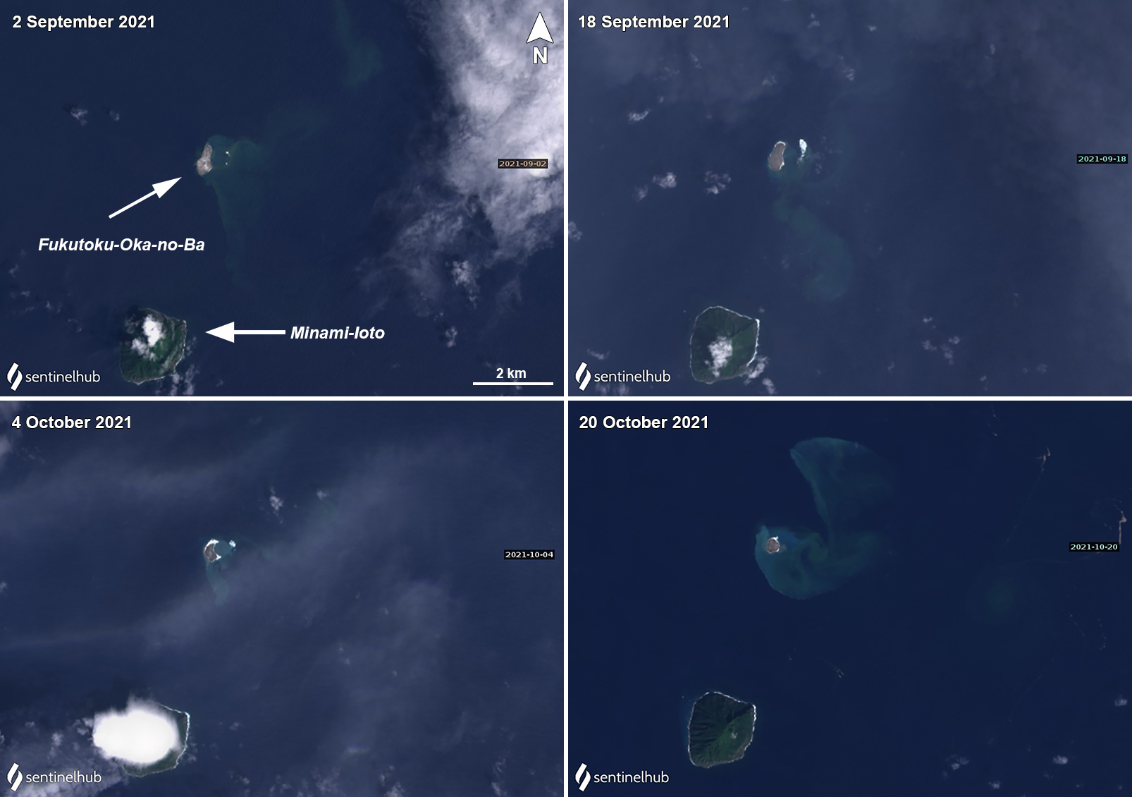 |
Figure 33. Landsat-8 satellite images track the appearance and direction of discolored water at Fukutoku-Oka-no-Ba on clear weather days. A strong yellow-green discolored water surrounded the island on 2 September (top left), 18 September (top right), 4 October (bottom left), and 20 October (bottom right) 2021, though as time progresses the size of the island noticeably decreases. Landsat-8 satellite images with “True Color” rendering. Courtesy of Sentinel Hub Playground. |
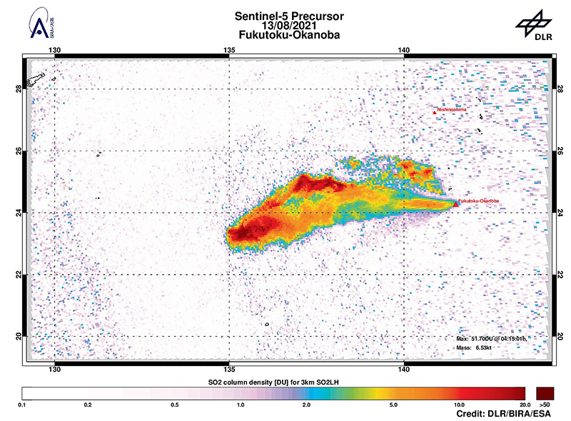 |
Figure 34. Image of a strong sulfur dioxide plume drifting W from Fukutoku-Oka-no-Ba on 13 August 2021 as far as 350 km at an altitude of about 3 km. Data is from the Sentinel-5P satellite. Courtesy of DLR, BIRA, and ESA. |
Information Contacts: Japan Meteorological Agency (JMA), 1-3-4 Otemachi, Chiyoda-ku, Tokyo 100-8122, Japan (URL: http://www.jma.go.jp/jma/indexe.html); Japan Coast Guard (JCG) Volcano Database, Hydrographic and Oceanographic Department, 3-1-1, Kasumigaseki, Chiyoda-ku, Tokyo 100-8932, Japan (URL: http://www.kaiho.mlit.go.jp/info/kouhou/h29/index.html); NASA Global Sulfur Dioxide Monitoring Page, Atmospheric Chemistry and Dynamics Laboratory, NASA Goddard Space Flight Center (NASA/GSFC), 8800 Greenbelt Road, Goddard MD 20771, USA (URL: https://so2.gsfc.nasa.gov/); NHK Japan Broadcasting Corporation, 2-2-1 Jinnan, Shibuya-ku, Tokyo 150-8001, Japan (URL: https://www.nhk.or.jp/, https://twitter.com/nhk_news/media); Yukio Hayakawa, Gunma University, Japan, 371-8510 Gunma, Maebashi, Aramakimachi, 4-2 (URL: http://www.hayakawayukio.jp/, https://twitter.com/HayakawaYukio); Yutaka Kosugi (URL: https://twitter.com/yutaka_kosugi); German Aerospace Center (DLR), Linder Höhe, 51147 Koeln, Germany (URL: https://www.dlr.de/en); Royal Belgian Institute for Space Aeronomy (BIRA-IASB), Ringlaan 3, Avenue Circulaire 3, 1180 Brussels (URL: https://www.aeronomie.be/index.php/en); The European Space Agency (ESA), 24 rue du Général Bertrand, CS 30798, 75345 Paris CEDEX 7, France (URL: https://www.esa.int/).
2021: August
| September
| October
| November
| December
2010: February
2005: June
The Japan Coast Guard reported that during a 27 December overflight of Fukutoku-Oka-no-Ba, observers noted that the island formed in mid-August had become smaller since 14 December, and had almost eroded below the ocean surface. No eruptive activity was observed, though brownish water spouted from the E end of the island. Yellowish-green water and a string of floating pumice, 400 m long, was circulating 5 km E. Discolored water was visible around almost the entire coast of Minami-Ioto (5 km SSW).
Source: Japan Coast Guard
The Japan Coast Guard reported that during an 11 November overflight of Fukutoku-Oka-no-Ba, observers noted that the size of the W island was mainly unchanged. White fumarolic plumes rose from the N end of the island and bubbling was seen on the ocean surface near the N end.
Source: Japan Coast Guard
The Japan Coast Guard reported that floating pumice from the mid-August Fukutoku-Oka-no-Ba eruption had arrived at coastlines more than 1,000 kilometers away in early October. The pumice first arrived at Kitadaito Island (1,035 km W) on 8 October. In late October pumice circled Okinawa and Maejima islands (1,422 km W) and several ports in the Kagoshima prefecture (1,322 NW). The pumice damaged hundreds of boats and ships, clogged harbors, and impacted the fishing and tourism industries in several areas. Several local governments began the process of removing the pumice from the water.
Sources: Japan Coast Guard; The Japan Times; The Guardian News
The Japan Coast Guard reported that during a 12 September overflight of Fukutoku-Oka-no-Ba, observers noted that the W island was unchanged while the E side had been completely eroded and submerged. Yellow-green to yellow-brown discolored water extended from the vent area to the SW, S, and SE, suggesting continuing eruptive activity. Another area of discolored water had an approximate diameter of 2 km and was about 2 km ENE of the volcano. The discolored water prompted JMA to issue a navigation warning to nearby vessels.
Source: Japan Coast Guard
The Japan Coast Guard reported that during a 26 August overflight of Fukutoku-Oka-no-Ba, observers noted that the W island was unchanged while the E side had mostly eroded, leaving two small islands. While no eruptions were visible, gray material from the central vent was intermittently ejected to the sea surface and brown, discolored water was widely distributed, especially to the W.
Source: Japan Coast Guard
The Japan Coast Guard reported that the eruption at Fukutoku-Oka-no-Ba continued during 16-22 August. Gas-and-steam emissions continued to be observed from the center of the island on 16 August. The pumice raft that was first identified on 15 August had expanded to about 100 km to the WNW and was about 13 km wide. Brown discoloration was visible surrounding the new island, which had a variable shape but a consistent diameter of 1 km by 16 August.
A local fisherman in the Ogasawara Islands who was fishing in South Iwo Jima (5 km NNE) posted photos and videos on 17, 20, and 22 August that showed strong white gas-and-steam plumes rising above the volcano. On 20 August lightning was visible within the gas-and-steam plume. On 22 August the plume was observed during 0430-0630.
Sources: Japan Coast Guard; Yutaka Kosugi
JMA reported that a large eruption at Fukutoku-Oka-no-Ba commenced around 0620 on 13 August based on satellite data. Ash plumes rose as high as 16 km (54,000 ft) a.s.l. and drifted W. The eruption was also confirmed during an overflight later that day. Video showed Surtseyan explosions ejecting black material above the ocean’s surface, and ash plumes drifted W. Ash plumes identified in satellite images rose 12.2-16 km (40,000-54,000 ft) a.s.l. during 13-15 August; the height of the plume decreased afterwards though the eruption intermittently continued. The Japan Coast Guard observed a new horseshoe-shaped island that was about 1 km in diameter during an overflight on 15 August. They also observed and photographed a notable pumice raft swirling with the currents as far as 60 km NW. JMA noted that the volcano last erupted in 2010 and frequent episodes of discolored seawater had been observed since then.
Sources: Japan Meteorological Agency (JMA); Japan Coast Guard; Tokyo Volcanic Ash Advisory Center (VAAC)
According to news articles, JMA reported Surtseyan explosions from Fukutoku-Okanoba, 5 km NE of the island of Minami-Iwo-jima, on 3 February. Steam-and-ash plumes rose 100 m a.s.l. and the surrounding sea turned yellow-green. Video footage of the event was captured by people aboard a Japanese Coast Guard patrol boat. One article stated that the sea in the area had regularly changed colors since the 1950s, most recently in December 2009.
Sources: The Mainichi Daily News; ITN News
On the evening of 2 July, members of the Japan Coast Guard observed a steam plume rising ~1 km above the sea near the island of Minami-Iwo-jima. On 3 July, JMA confirmed that a small-scale eruption had occurred at the submarine volcano Fukutoku-Okanoba, prompting the Japan Coast Guard to issue a warning against sailing in the area. Observers saw rock and mud rising to the sea's surface near the volcano and a ~1-square-km area of water that had turned orange-brown. As of 4 July, a new island had not formed.
Sources: Associated Press; Daily Yomiuri News; Reuters
Reports are organized chronologically and indexed below by Month/Year (Publication Volume:Number), and include a one-line summary. Click on the index link or scroll down to read the reports.
Eruption building new island
Card 2130 (28 March 1975) Eruption building new island
The following cable was received from Fleet Weather Central, Guam. "On 25 March 1975 a U.S. Air Force reconnaissance flight operating out of Guam sighted an area of oceanic volcanic activity 32 km S of Iwo Jima. The sighting was described as possibly an island in the formative stages. Photographs were taken by the crew. Fleet Weather Central, Guam, is closely watching weather satellite coverage for the area for any signs of further activity."
Information Contacts: Fleet Weather Central, U.S. Air Force, Guam, Mariana Islands.
Possible submarine eruption in December 1974
[A table of possible submarine eruptions based on aerial observations of water discoloration by the Japanese Maritime Safety Agency included an entry for 24.28°N, 141.50°E, in December 1974. This location is very close to Fukutoku-Okanoba. In March 1975 another observation was listed at 24.42°N, 141.32°E; this is ~25 km NW of Fukutoku-Okanoba and ~36 km S of Iwo-jima.]
Information Contacts: AFP; U.S. Defense Mapping Agency.
Water discoloration observed during August 1976
[A report of surface discoloration in March was removed at JMA's request.] The last reported activity in this area was a [green] discoloration in August 1976.
Information Contacts: JMA, Tokyo.
Sea surface discoloration in May
Sea surface discoloration was observed from the air on 1, [12, 13, 16, 17, 21, 22, and 25 May].
Information Contacts: JMA, Tokyo; D. Shackelford, CA.
Water discoloration observed October-December 1977 and January 1978
Discoloration was observed on 14 October 1977, 15 and 25 November 1977, 8 and 23 December 1977, and 10, 24, and 25 January 1978.
Information Contacts: JMA, Tokyo.
Sea water discoloration
Aerial reconnaissance by the JMSA in late January showed slight discoloration of the ocean around this volcano, at 24.30°N, 141.48°E.
Information Contacts: Y. Sawada, Meteorolgical Research Institute, Tokyo; D. Shackelford, CA.
Discolored water observed in 1978 and 1979
Activity has been observed at six submarine volcanoes in the Volcano Island chain in 1978 and 1979 (figure 1). Discolored water has often been visible . . . during frequent overflights by JMSDF and JMSA aircraft. [Discolored water was noted, in an included table of observations, by almost every overflight during January 1978-July 1979 (see table 1 below).]
 |
Figure 1. Map showing Japan and the Volcano Island chain. Volcanoes active in 1978 or 1979 are indicated by black squares. Courtesy of JMA. |
Information Contacts: JMSA, Tokyo; JMA, Tokyo.
Discolored water in late 1979 and early 1980
The Japan Maritime Safety Agency continues frequent monitoring flights over three known submarine volcanoes. [Discolored water at Fukutoku-Okanoba was seen during September 1979-March 1980 (see table 1 below).]
Information Contacts: JMSA, Tokyo; JMA, Tokyo.
Discolored water seen during April-July 1980
The Japan Maritime Safety Agency (JMSA) continues frequent monitoring flights over several known submarine volcanoes. [Discolored water at Fukutoku-Okanoba was seen during April-July 1980 (see table 1 below).]
Information Contacts: JMSA, Tokyo; JMA, Tokyo.
Water discoloration observed in November and December 1980
The Japanese Maritime Safety Agency (JMSA) continues frequent aerial monitoring of several known submarine volcanoes. [Discolored water was seen at Fukutoku-Okanoba on 14 November and 18 December 1980 (see table 1 below).]
Information Contacts: JMSA, Tokyo; JMA, Tokyo.
Frequent water discoloration observed during January-October 1981
The Japan Maritime Safety Agency (JMSA) continues frequent monitoring flights over several known submarine volcanoes. [Discolored water at Fukutoku-Okanoba was specifically noted, in an included table of observations, on 9 and 29 January, 12 and 20 February, 12, 13, and 16 March, 20 April, 16, 17, and 22 July, 17 August, and 17 September 1981 (see table 1 below).]
Information Contacts: JMSA, Tokyo; JMA, Tokyo.
Discolored water observed on flights during December 1981-June 1982
JMSA [and JMSDF have] continued frequent monitoring flights over several known submarine volcanoes (table 1). On almost all overflights discolored sea water was seen around Fukutoku-Okanoba, the most active submarine volcano in this area.
Table 1. Volcanic activity at three sites (Fukutoku-Okanoba, Minami-Hiyoshi, and Fukujin) in the Volcano Islands, January 1978-December 1982, detected by JMSA and JMSDF monitoring flights. Activity indicated as D = Discolored water; N = No discolored water, - = No overflight, ? = not reported. This table combines data from reports in 1979 (4:7), 1980 (5:4, 5:11, and 5:12), 1981 (6:10), and 1982 (7:9, plus additional data not published in the Bulletin).
| Date | Fukutoku-Okanoba | Minami-Hiyoshi | Fukujin |
| 10 Jan 1978 | D | N | D |
| 24 Jan 1978 | D | N | D |
| 25 Jan 1978 | D | - | D |
| 26 Jan 1978 | - | D | D |
| 23 Feb 1978 | D | D | N |
| 24 Mar 1978 | D | D | D |
| 13 Apr 1978 | D | N | N |
| 25 May 1978 | D | N | N |
| 28 Jun 1978 | D | - | - |
| 29 Jun 1978 | D | N | N |
| 25 Aug 1978 | D | N | D |
| 24 Oct 1978 | N | N | N |
| 15 Nov 1978 | D | - | - |
| 16 Nov 1978 | D | N | N |
| 14 Dec 1978 | D | N | N |
| 11 Jan 1979 | D | - | - |
| 24 Jan 1979 | D | N | N |
| 08 Feb 1979 | D | N | N |
| 27 Mar 1979 | D | [N] | - |
| 26 Apr 1979 | D | N | D |
| 15 Jun 1979 | N | N | N |
| 11 Jul 1979 | N | - | - |
| 12 Jul 1979 | D | N | D |
| 24 Aug 1979 | N | N | - |
| 09 Sep 1979 | D | - | - |
| 13 Sep 1979 | D | N | N |
| 25 Oct 1979 | D | N | D |
| 08 Nov 1979 | D | N | D |
| 12 Dec 1979 | D | N | D |
| 29 Jan 1980 | - | - | D |
| 15 Feb 1980 | D | N | D |
| 19 Mar 1980 | D | N | D |
| 24 Apr 1980 | D | N | N |
| 12 May 1980 | D | - | D |
| 16 Jun 1980 | D | N | N |
| 07 Jul 1980 | D | - | - |
| 08 Jul 1980 | D | N | N |
| 14 Jul 1980 | D | N | N |
| 18 Aug 1980 | N | N | N |
| 04 Sep 1980 | N | N | N |
| 21 Oct 1980 | N | N | N |
| 14 Nov 1980 | D | N | N |
| 18 Dec 1980 | D | N | N |
| 07 Jan 1981 | - | - | D |
| 08 Jan 1981 | - | - | D |
| 09 Jan 1981 | D | N | N |
| 29 Jan 1981 | D | - | - |
| 12 Feb 1981 | D | [-] | - |
| 20 Feb 1981 | D | [N] | N |
| 12 Mar 1981 | D | [-] | - |
| 13 Mar 1981 | D | N | N |
| 16 Mar 1981 | D | N | N |
| 20 Apr 1981 | D | N | N |
| 17 Jun 1981 | N | N | N |
| 16 Jul 1981 | D | - | - |
| 17 Jul 1981 | D | [N] | [N] |
| 22 Jul 1981 | D | N | N |
| 17 Aug 1981 | D | N | N |
| 17 Sep 1981 | D | N | N |
| 19 Oct 1981 | N | N | N |
| 11 Nov 1981 | N | N | [-] |
| 21 Dec 1981 | D | N | N |
| 12 Jan 1982 | - | - | D |
| 19 Jan 1982 | D | N | D |
| 09 Feb 1982 | D | N | N |
| 28 Feb 1982 | D | - | - |
| 16 Mar 1982 | D | N | D |
| 01 Apr 1982 | D | - | N |
| 02 Apr 1982 | D | N | N |
| 16 Apr 1982 | D | N | N |
| 14 May 1982 | D | N | N |
| 16 Jun 1982 | D | N | N |
| 22 Jun 1982 | D | - | - |
| 13 Jul 1982 | D | ? | N |
| 20 Aug 1982 | D | ? | N |
| 27 Sep 1982 | D | ? | N |
| 13 Oct 1982 | D | ? | N |
| 17 Nov 1982 | D | ? | N |
| 15 Dec 1982 | D | ? | D |
Information Contacts: JMA, Tokyo.
Discolored water observed on 12 days in 1983
Frequent monitoring of several known submarine volcanoes has continued. . . . [Discolored water was observed at Fukutoku-Okanoba in 1983 on 14 January, 2 and 15 February, 3 and 15-16 March, 24 May, 16 June, 20 July, 25 October, 11 November, and 12 December; and was not visible 12 July, 25 August, and 13 September.]
Information Contacts: JMA, Tokyo.
Discolored water
A milky white discoloration, about 100 m in diameter, was observed on 17 September and discoloration was noted again on 17 October.
Information Contacts: JMA, Tokyo.
Water discoloration observed frequently during December 1983-October 1985
JMSA has continued frequent aerial monitoring of several known submarine volcanoes. Volcanic activity has often been observed at Fukutoku-Okanoba during overflights since late 1983 . . . . Discolored water was observed at Fukutoku-Okanoba on: 21 December 1983; 30 January, 23 February, 15 March, 6 and 23 April, 18 May, 9 June, 10 July, 1 August, 6 September, and 16 November 1984; and 14 February, 15 March, 17 April, 14 May, 17 September, and 17 October 1985; and was not visible 26 September, 24 October, and 12 December 1984.
[Additional water discoloration in 1985 was reported (Bulletin of Volcanic Eruptions no. 25, 1988) on 14 June, 17 July, 13 August, 14 November, and 23 December.]
Information Contacts: JMA, Tokyo.
Explosive eruption builds island
On 18 January, fishermen observed a large white plume rising to more than 3 km altitude and lava being ejected to about 300 m height form the vicinity of the submarine volcano Fukutoku-Okanoba. The eruption was first evident on infrared imagery from the Japanese GMS geostationary weather satellite on 18 January at 2100. Japan Maritime Self-Defense Force personnel stationed on Iwo-Jima, about 50 km from Fukutoku-Okanoba, observed a 4-km eruption cloud the next day at 1630. The Japan Maritime Safety Agency's survey ship Takuyo found a new island about 5 km NE of Minami Iwo Jima (south Iwo Jima) the morning of 21 January. The new island, about 700 m long and 300 m wide, extended about 15 m above sea level. Lava was being ejected to about 300 m height. As of 21 January, floating pumice had drifted 60 km to the SE.
Information Contacts: JMA, Tokyo; UPI; AP
New island formed
An eruption . . . built a small island in mid-January. Only milky blue discolored sea water was observed near the volcano on 16 January at about 1200. By 18 January at 2000, eruptive activity was frequent, producing a dark plume, seen from a fishing boat, that reached 3,000-4,000 m height. An hour later the plume was evident on an image from Japan's GMS satellite. The next day at about 1630, airborne radar detected a plume rising to 4,000 m above sea level. On 20 January at 0440, radar on the JMSA's survey ship RV Takuyo showed an island-like image. A gray plume rose to 2,000 m altitude at 0550.
A new island was recognized by observers on the RV Takuyo at 0630. A 50-m vent at the NW edge of the new island ejected plumes and sea water. Continuous observations were made until about 1000. The island was ~700 m long, 500 m wide, and 15 m high (figure 2). A vent near its E edge remained below sea level, ejecting black incandescent rocks as much as 10 m in diameter. Grayish brown pumice had drifted as much as 18 km NE from the vent. Discolored sea water surrounded the island and extended 22 km NE from the vent. The sea water was greenish near the island, gradually becoming greenish yellow or pale blue farther from the vent.
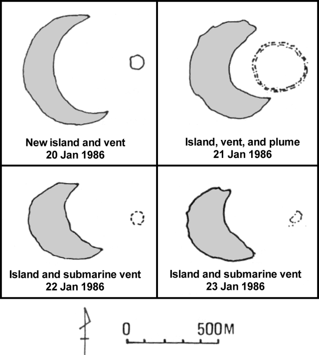 |
Figure 2. Sketch maps of the new island and associated vent and plume at Fukutoku-Okanoba, 20-23 January 1986. Courtesy of JMA. |
At 1122 a dark plume containing incandescent rocks to 10 m in diameter rose 1,200-1,300 m above sea level; between 1250 and 1400 a vapor plume rose to 3,000 m. There was a zone of discolored water ~45 km long and 2-3 km wide. Between 1450 and 1550, explosions occurred at about 20-minute intervals, expelling dark plumes that rose ~1,200-1,700 m. Between 1600 and sunset, 90 weak to moderate explosions ejected plumes to 100-1,000 m height. Volcanic flame was occasionally seen within dark plumes at night.
The next morning at 0800 explosions produced small plumes (less than 50 m high) at intervals of 1-2 minutes. At 1223, a large explosion was seen; volcanic flame reached 1,500 m above sea level, roughly half of the plume's height. At 1300 the island was flat and crescent-shaped, covered with ash and pumice but no lava flow. The outer arc of the crescent was a portion of a circle ~700 m in diameter having a center that roughly coincided with the position of the active vent, which was ~300 m in diameter (figures 3 and 4). An area of thin yellow or green discoloration extended SSE to 2 km from the island. Pumice drifted E and S.
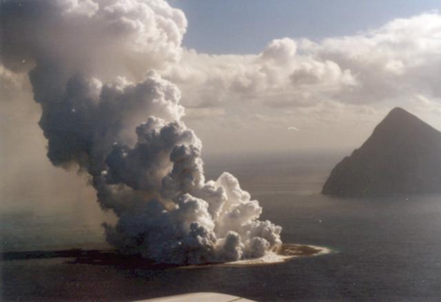 |
Figure 3. Photograph of the new island and eruption plume at Fukutoku-Okanoba on 21 January 1986 at about 1400. The conical island in the right background is Minami-Iwo-jima. Photo by G. Iwashita, JMA. |
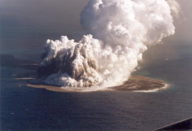 |
Figure 4. Photograph of the new island and eruption plume at Fukutoku-Okanoba on 21 January 1986 at about 1600. Photo by G. Iwashita, JMA. |
By the morning of the 22nd explosive activity had subsided; no plumes were seen for the rest of the month. Erosion of the shoreline of the new island was evident early the next day. However, at 1300 outflow of discolored sea water suggested that the submarine vent, 80 m in diameter, was still active ~400 m E of the island.
The island, covered with gray ash, was ~500 m in length and had a maximum width of 200 m. During the morning of 25 January, dense blue discoloration was seen around and E of the island and had drifted somewhat eastward, to ~9 km from the vent. On the 29th the island's size was estimated at ~600 m long, ~400 m wide and ~10 m high (this preliminary estimate does not necessarily indicate growth since the 23rd). Yellowish green discoloration extended as much as 38 km to the NE, and brown pumice was floating in lines near the island.
Between 20 December and 20 January, nearly 100 T-phase waves of moderate intensity were received by high-gain seismic stations at Rangiroa, Tuamoto Islands (~9,000 km SE of Fukutoku-Okanoba). J.M. Talandier noted that T-phase waves are characteristic of submarine eruptions, having shallow (ocean) depth. The origin of these waves was in the NW Pacific, and they may be related to the eruption of Fukutoku-Okanoba.
Discolored water has frequently been observed around Fukutoku-Okanoba in recent years. In an interview on a Japan Broadcasting Network newscast, Professor Kosaka of Okayama Univ reported that about 8 years ago a sonar survey from the Tokyo Fisheries Univ ship Seio-maru detected a seamount with a summit 40 m below sea level and roughly 150 m wide, beneath the discolored water zone at Fukutoku-Okanoba. Small islands were formed during the 1904-1905 and 1914 eruptions, but did not persist after 1905 and 1916. An island was reported during an eruption on 24 December 1974, but was not visible the next day.
Information Contacts: JMA; J. Talandier, Laboratoire de Geophysique, Tahiti; NHK Japan Broadcasting Corporation, Tokyo.
New island erodes; floating pumice
The island formed 20 January . . . has been eroded away by wave action since volcanic activity ceased. The island's disappearance was reported by the JMSDF after an hour-long helicopter flight that began 8 March at 0745. The surface of the new edifice was seen under white water, and there was no sign of a volcanic plume.
On 28 January, airplane pilots observed light brown floating pumice within a roughly rectangular NW-SE-trending zone ~200 km long by 50 km wide, extending from ~100 to 300 km SE of the volcano. The pumice was in subparallel teardrop-shaped rafts roughly 4 km wide and 10 km long, elongate perpendicular to the apparent direction of drift.
Rocks collected from Fukutoku-Okanoba after previous eruptions in 1904, 1914, and 1982 were trachyandesites with high alkali contents.
Information Contacts: M. Matson, NOAA/NESDIS; Kyodo Radio, Tokyo; UPI.
January island eroded below sea level
Water discoloration was seen on every overflight in February and March. Wave action gradually eroded the island built by the January eruption, and JMSA personnel reported that it was entirely below sea level by the time of their overflight on 26 March.
Information Contacts: JMA; JMSA.
Discolored sea water
Airplane pilots have observed discolored water at the volcano during all overflights after the temporary island was eroded below sea level in late March. No eruptive activity was reported. The length of the zone of discolored sea water was 0.3 km on 16 April, 2 km on 19 May, and 25 km on 18 June.
Information Contacts: JMA; JMSA.
Submarine eruptions; floating pumice
On 14 July at about 1240, discolored and spouting seawater was reported by observers on a fishing boat. Sprays reached 10 m above the water surface for about a minute at intervals of 10-15 minutes. The next day, 100-150-m-diameter, circular, white-crested waves with spouts in their centers formed at intervals of 6 minutes throughout a 50-minute JMSA overflight. Some floating pumice was found within a zone of yellowish-green seawater that was 500 m wide and stretched 18 km E. No white-crested waves formed after 16 July. During a 17 July overflight, a 30-100 m-wide area of green seawater extended 13 km E. Pumice floated at the E end of this area. On 21 July discolored seawater spread out from two points and minor amounts of pumice were floating in the area. On 30 July deep-green discolored water extended as far as 9 km E over an area 0.5-2 km wide and contained floating brown pumice.
Information Contacts: JMA.
Discolored and spouting seawater
Discolored seawater continued to be seen in August by the JMSA. On 1 August, a zone of yellow-green seawater stretched 3 km NW-SE. The next day water over the vent was discolored green. Discolored water was next reported on 13 August, when cobalt-blue water covered an area of 0.01 x 4 km along an E-W axis. On 17 August the discolored area was 3 km in diameter, and spouting seawater was seen twice. No floating pumice was observed.
Information Contacts: Y. Sawada, JMA; D. Shackelford, Fullerton, CA.
Pale green discolored water
JMSA observed pale green discolored water above the volcano on 17 September.
Information Contacts: Y. Sawada, JMA; D. Shackelford, Fullerton, CA.
Discolored water
JMSA observed sea discolorations on 12 August in an area of 0.09 x 0.9 km and on 15 September in a zone of 0.05 km (N-S) by 1.8 km (E-W).
Information Contacts: Y. Sawada, JMA; D. Shackelford, Fullerton, CA.
Thermal activity discolors sea water
Thermal activity has continued since the January 1986 eruption (11:1-3). A pale green belt of discolored sea water and white bubbles was observed during a JMSA overflight on 9 May 1989. Another monitoring flight, on 14 June, revealed a 50 x 400 m zone near the vent that was discolored cobalt blue.
Information Contacts: JMA; D. Shackelford, Fullerton, CA.
Frequent observations of discolored water
Aerial observations of the ocean surface above the submarine volcano revealed discolored water in January-May, September, and November (table 2). The longest discoloration, 8 km, was observed during an overflight on 17 January. Thermal activity has continued since the January 1986 eruption . . . . Discolored water has been frequently observed since that time (14:07). No discolorations were observed at other submarine volcanoes (Kaitoku, Minami-Hiyoshi, Nikko, and Fukujin seamounts) during 1990.
Table 2. Discolored water at Fukutoku-Okanoba, observed from monthly overflights in 1990. Courtesy of JMSA.
| Date | Water Color | Length of Discoloration |
| 17 Jan 1990 | yellowish brown | 8 km |
| 20 Feb 1990 | green | 7 km |
| 27 Mar 1990 | green and brown | 1.8 km |
| 17 Apr 1990 | blue | 0.3 km |
| 16 May 1990 | blue | 0.05 km |
| Jun 1990 | no discoloration | -- |
| Jul 1990 | no discoloration | -- |
| Aug 1990 | no discoloration | -- |
| 13 Sep 1990 | pale green | 3.6 km |
| 15 Oct 1990 | no discoloration | -- |
| 20 Nov 1990 | yellowish green | 0.7 km |
| Dec 1990 | no discoloration | -- |
Information Contacts: Hydrographic Department, JMSA.
Water discoloration during one of five overflights
A blue water discoloration, extending 2 km E-W, was observed during a 6 February overflight by the JMSA. Overflights on 18 January, 12 March, 15 April, and 10 May revealed no abnormal water.
Information Contacts: JMA.
Water discoloration over submarine vent
A greenish water discoloration was observed during a 30 September overflight by the JMSA. No discoloration was present during a similar overflight on 21 August.
Information Contacts: JMA.
Discolored water
An 18 October overflight by the JMSA revealed discolored green water over the submarine volcano.
Information Contacts: JMA.
Pumice ejected by submarine eruption
A dark plume was observed [in the air above Fukutoku-Okanoba] by fishing crews at about 0800 on 10 November. An overflight by the JMSA from 1315 to 1350 revealed discolored pale-green water in a narrow fan shape to 10 km NNW from the volcano. Brown pumice was seen but no ejections were observed at that time. An overflight on 12 November between 1215 and 1250 revealed that water discoloration was reduced to a zone extending 1 km NW without floating pumice, indicating a decrease in activity. An area of discolored water 2 km long was seen in August but no discoloration was observed during the last overflight before the eruption, on 22 October.
Information Contacts: JMA; JMSA.
Smaller zone of discolored water; no new pumice
Overflights by the JMSA on 12 and 18 November revealed a smaller and weaker area of discolored water over the submarine volcano than on 10 November. The height and size of the dark plume seen by fishermen on 10 November are not known, nor is is known whether the plume contained tephra. Floating pumice was observed that day, but none has been reported since then.
Information Contacts: JMA; JMSA.
Discolored water observed over volcano four times in 1993
Discolored seawater over an area a few hundred meters wide was seen during monthly aerial observations . . . in February, March, June, and September 1993.
Information Contacts: JMA.
Discolored seawater
An aviator flying over the waters of the southern Volcano Islands for Japan's Maritime Safety Agency reported seeing light-green seawater on 25, 27, and 28 November. Discolored seawater was last seen at this location in September 1993.
Information Contacts: Volcanological Division, Seismological and Volcanological Department, Japan Meteorological Agency (JMA), 1-3-4 Ote-machi, Chiyoda-ku, Tokyo 100 Japan.
Discolored seawater observed for the second time in three months
On 12, 22, and 23 January, an aviator from the Japan Marine Safety Agency (JMSA) reported distinct discoloration of seawater to yellowish green. Similar discoloration was seen during 25-28 November 1995 (BGVN 20:11/12). Prior to that, discolored seawater was last seen at this location in September 1993.
Information Contacts: Volcanological Division, Seismological and Volcanological Department, Japan Meteorological Agency (JMA), 1-3-4 Ote-machi, Chiyoda-ku, Tokyo 100 Japan.
Emission of colored water and long discolored aqueous plumes
Aviators from the Japan Marine Safety Agency (JMSA) began observing yellowish-green discoloration of seawater during 25-28 November 1995 (BGVN 20:11/12). Similar discoloration was seen on 12, 22, and 23 January 1996 (BGVN 21:01), and also on 26 January, as reported by the Japan Meteorological Agency.
Information from the Volcano Research Center revealed that JMSA observers once again noted yellowish brown discolored seawater in the area on 4 April. According to the reports, the colored area expanded like a belt up to ~3 km long. Strong emission of colored water was recognized from two points. Although white-colored suspension was observed on the surface, floating pumices were not recognized. Yellowish-green to yellowish-brown water observed on 12 April formed a plume ~4 km long and 200 m wide, including 3-4 spots from which colored-water was gushing out intermittently. No pumices were recognized.
Information Contacts: Volcanological Division, Seismological and Volcanological Department, Japan Meteorological Agency (JMA), 1-3-4 Ote-machi, Chiyoda-ku, Tokyo 100 Japan; Volcano Research Center, Earthquake Research Institute, University of Tokyo, Yayoi 1-1-1, Bunkyo-ku, Tokyo 113, Japan (URL: http://www.eri.u-tokyo.ac.jp/VRC/index_E.html); Hydrographic Department, Maritime Safety Agency, 3-1 Tsukiji, 5-Chome, Chuo-ku, Tokyo 104, Japan.
Yellowish-brown discolored seawater seen again
On 4 April, an aviator from the Japan Marine Safety Agency reported discoloration of seawater to yellowish brown at Fukutoku-Okanoba (BGVN 21:03). On 6 and 7 April, similar discoloration was observed by an aviator of the Maritime Defense Force. More discoloration was reported on 12 and 30 April. No floating pumice was observed. Discolored seawater has been seen on a smaller scale at this location, since 24 November 1995 (BGVN 20:11/12).
Information Contacts: Volcanological Division, Seismological and Volcanological Department, Japan Meteorological Agency (JMA), 1-3-4 Ote-machi, Chiyoda-ku, Tokyo 100, Japan.
Discolored seawater
During the first half of May, aviators of the Maritime Safety Agency and the Maritime Self-Defense Force reported discoloration of seawater at Fukutoku-Okanoba. Similar discoloration has been observed since November 1995 (BGVN 20:11/12, 21:01, 21:03, and 21:04). An overflight on 23 May indicated no discolored seawater.
Information Contacts: Japan Meteorological Agency (JMA), Volcanological Division, Seismological and Volcanological Department, 1-3-4 Ote-machi, Chiyoda-ku, Tokyo 100, Japan.
Water discoloration from submarine volcano observed in September
On 6 September, a Japan Maritime Safety Agency aviator reported yellow-green (in part yellowish brown) discoloration of seawater at Fukutoku-Okanoba over an area of 50 x 150 m, and to light green over a 300 x 500 m area. On 18 September green discoloration was seen by an aviator of the Japan Maritime Self-Defense Force. Smaller areas of discolored seawater have been seen at this location since 24 November 1995 (BGVN 20:11/12, v. 21, nos.1 and 3-5).
Information Contacts: Volcanological Division, Japan Meteorological Agency (JMA), 1-3-4 Ote-machi, Chiyoda-ku, Tokyo 100, Japan; Volcano Research Center, Earthquake Research Institute (ERI), University of Tokyo, Yayoi 1-1-1, Bunkyo-ku, Tokyo 113, Japan (URL: http://www.eri.u-tokyo.ac.jp/VRC/index_E.html).
Submarine venting continues to discolor seawater
On 12 December, a Japan Maritime Safety Agency aviator reported yellow-green discoloration of seawater at Fukutoku-Okanoba over a 50 x 200 m area. On 27 January, pale green discoloration was seen by an aviator of the Japan Maritime Safety Agency covering an area of 2,000 x 100 m.
Information Contacts: Volcanological Division, Japan Meteorological Agency (JMA), 1-3-4 Ote-machi, Chiyoda-ku, Tokyo 100, Japan.
July 2005 submarine eruption; discolored water and debris
Notice of Fukutoku-Okanoba unrest in 2005 first came to Bulletin editors from Olivier Hyvernaud, information that was amplified by the Japanese Meteorological Agency (JMA) Volcanic Activity Reports of July and October 2005. The JMA reports contain information from the Japanese Marine Defense Forces as well as the Marine Security and Safety Agency and the Tokyo Institute of Technology. In addition, a Japan Coast Guard website (see URL below) contains a more extensive (and yet untranslated) table on recent events at Fukutoku-Okanoba, which includes photos and videos of the July eruption. That table clearly illustrates activity both earlier and later than the 2-3 July eruption, and several other details not discussed here, including the observation of numerous large and steaming blocks floating on the ocean surface at mid-day on 3 July. Bulletin editors hope to decipher this table and include more details in a later report.
The last five Bulletin reports discussing or mentioning Fukutoku-Okanoba appeared in BGVN 22:01, 24:11, 24:12, 25:05, and 28:06 (1997-2003). Note that the last four cases were considered ambiguous and grouped along with reports under the heading "Acoustic signals in 1999-2000 from unknown source, Volcano Islands, Japan" and only the first case was listed under the volcano name). A 3-d view of the volcano and its setting appears as figure 5.
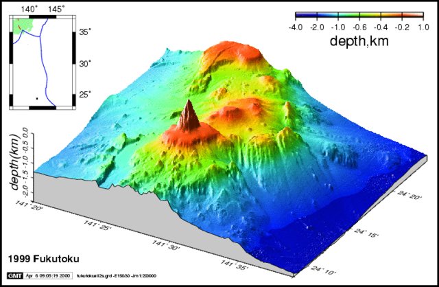 |
Figure 5. Fukutoku-Okanoba and vicinity shown in a 3-dimensional diagram, with shading (or color) representing various elevation ranges (see key above); vertical exaggeration is considerable but was not stated. The inset contains an index map showing the Volcano islands along the Bonin trench. The diagram represents data from 1999 and views the region from the SE. Fukutoku-Okanoba is a submarine vent ~ 5 km N of the island (Minami-Iwo-jima). Copyrighted image courtesy of the Japan Coast Guard. |
JMA reported that at about 1745 on 2 July 2005, a white plume was witnessed at Fukutoku-Okanoba. During an investigation at 1900 that same day, a white plume reached ~ 1 km above the sea surface. A photo taken from considerable distance was included in the JMA report, showing the plume, but the image's limited contrast has led to its exclusion here. In addition to the plume, other evidence for an eruption included debris on the sea surface. When seen on 2 July, the debris covered an area approximately 100 m wide and 300 m long.
JMA noted that 3 July aerial observations suggested that compared to the previous day, eruptive vigor and the height of the white plume had decreased. The key observation then was a zone of discolored seawater (figure 6).
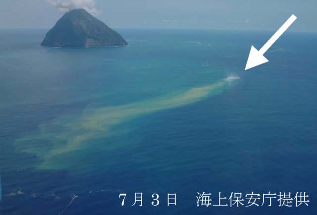 |
Figure 6. An aerial view of Fukutoku-Okanoba taken on 3 July 2005 as seen from the NE. Debris and discoloration extend from the arrow. Courtesy of the Maritime Security and Safety Agency. |
JMA's report of 4 and 5 July aerial investigations noted the lack of a white vapor plume over the sea. In other words, the 2-3 July eruption had calmed, but fresh debris and seawater discoloration were still present. After that, aerial investigations on 15, 17, 20, and 21 July, again disclosed seawater discoloration, but not the presence of floating debris.
The Maritime Security and Safety Agency conducted an underwater topographical survey on 20-22 July 2005, the result of which was the discovery of two craters caused by the recent eruption. The results suggested that the topography just S of those craters was newly raised.
According to a 3 October aerial observer, the ocean surface near Fukutoku-Okanoba, then displayed a pale, blue-white discoloration, interpreted as indicative of volcanism. The area of discoloration extended ~ 300 m in length to the E and was ~ 50 m wide (N-S) at its widest point. However, in the surrounding area they saw no floating debris or plumes containing ash or steam. On 27 October, an aerial observation could not confirm the seawater discoloration.
Satellite data. M. Urai (2005) reported that three days after the 2 July 2005 eruption of Fukutoku-Okanoba, satellite remote sensing using ASTER (Advanced Spaceborne Thermal Emission and Reflection Radiometer) observed the discolored seawater and floating materials within 40 km of the submarine volcano. Some of this abstract follows.
"At the most dense discolored seawater area, reflectance of ASTER band 1 is 3% higher [than] the surrounding seawater. The floating materials are similar in ASTER VNIR [Very Near-Infrared Radiometer] reflectance spectra to clouds, however, the floating materials can be separated from clouds using their shape and stereo image features. The extensions of discolored seawater area and floating material detected by ASTER were 6.34 km2 and 1.14 km2, respectively. It is possible to estimate the scale of [a] submarine eruption using the quantitative data derived from satellite remote sensing."
Distant hydrophones. Robert Dziak and Haru Matsumoto monitor N Pacific volcano seismicity with the National Oceanic and Atmospheric Agency/Pacific Marine Environmental Laboratory (NOAA/PMEL). They initially learned of the eruption via the internet. Regarding the 2 July eruption, Dziak wrote to the Bulletin staff on 22 November 2005. Some of his messages follow.
". . . the [N] Pacific hydrophone array we use recorded seismicity during the Fukutoku-Okanoba eruption near Iwo Jima. I was aware of the eruption at the time [mid 2005] thanks to Haru [Matsumoto; he designed and built the instruments used there to record the T-wave events] forwarding a news image of the discolored water. Despite being only able to roughly locate the seismicity since it is way west of our array, I am pretty sure Fukutoku-Okanoba was the source because the arrival azimuths and timing of the signals were a match. The last earthquake activity we recorded from this area occurred on 25 September [2005] . . .. A few years ago I was contacting you [Smithsonian Institution] about our recording of harmonic tremor from a source in the Volcano Islands. The conclusion I published in JGR [Dziak and Fox, 2002] was that either Fukutoku-Okanoba or Funka-asane ([N] of Iwo Jima) was the probable source because of a history of submarine volcanic activity at both volcanoes. We have still been recording this tremor intermittently over the last few years and another pulse of it occurred during the Fukutoku-Okanoba eruption on July 2, 2005. The last occurrence was on August 22.
According to an Email from Dziak on 23 November 2005, "...I think the tremor is coming from [Fukutoku-Okanoba or Funka-asane]. I was only able to get synchronous data from the French Polynesian seismic net (Hyvernaud). They confirmed the signals but it did not help much with location because they were so far away. My thought is the source of earthquakes and tremor from these submarine volcanoes is at an ocean depth within the sound channel. This allows for very efficient seismic-acoustic coupling and acoustic propagation throughout the Pacific ocean basin."
References. Dziak, R.P., and Fox, C.G., 2002, Evidence of harmonic tremor from a submarine volcano detected across the Pacific Ocean basin: Journal of Geophysical Research, v. 107(B5), p. 2085; doi 10.1029/2001JB0001772085.
Kato, Y., 1988, Gray pumices drifted from Fukutoku-oka-no-ba to the Ryukyu Islands: Bulletin of the Volcanological Society of Japan, Second Series, v. 33, p. 21-30.
Ossaka, J., Mitsuno, C., Shibata, T., Matsuda, T., Hirabayashi, J., Tsuchide, M., Sakurai, M., and Sato, H., 1986, The 1986 submarine eruption of Fukutoku-okanoba, Part 2. Volcanic ejectas: Bull. Vol. Soc. Japan, v. 31, p. 134-135.
Urai, M., 2005, Monitoring submarine volcano with satellite remote sensing: Eos Trans, AGU, v. 86(52), Fall Meet. Suppl., Abstract 611A-1176.
Information Contacts: Olivier Hyvernaud, Laboratoire de Géophysique, BP 640 Pamatai, Tahiti, French Polynesia; Japanese Meteorological Agency (URL: http://www.jma.go.jp/JMA_HP/jma/indexe.html); Robert Dziak and Haru Matsumoto, NOAA PMEL, Hatfield Marine Science Center, 2115 SE Oregon State University Drive, Newport, OR 97365, USA; Yukio Hayakawa (URL: http://www.hayakawayukio.jp/English.html/); Daily Yomiuri News (URL: http://www.yomiuri.co.jp/); Reuters; Associated Press; Tokyo Institute of Technology, 2-12-1 O-Okayama, Meguro-ku, Tokyo 152-8551, Japan; Japan Coast Guard, Hydrographic and Oceanographic Department (URL: http://www1.kaiho.mlit.go.jp/GIJUTSUKOKUSAI/kaiikiDB/kaiyo24-2.htm); Japan Maritime Security and Safety Agency, Oceanic Information Section (URL: http://www1.kaiho.mlit.go.jp/).
Discolored water attributed to submarine volcanism
Oliver Hyvernaud twice notified the Bulletin of Notice to Mariners reports of discolored sea water observed on 4 October and 15 November 2006 at about 24°17'N, 141°29'E. Both warnings referred to the same general location, encompassing an area of ocean 93 km SSW of Iwo Jima. In reality, the two positions noted below are ~ 1.3 km apart, perhaps overlapping each other. The warnings were as follows:
1) Discolored water with submarine volcanic activity reported within 1,700 m of 24°17.5' N, 141°29.4 E at 0400 UTC on 4 October 2006 [ref. Notice to Mariners, 14 October 2006 (no. 41), HYDROPAC Warning 1921/06(97) North Pacific, issued 1009 UTC on 4 October 2006].
2) Discolored water with submarine volcanic activity reported within 2,000 m of 24°17.1' N, 141°28.8 E at 0236 UTC on 15 November 2006 [ref. Notice to Mariners, 2 December 2006 (no. 48), HYDROPAC Warning 2225/06(97) North Pacific, issued 1133 UTC on 16 November 2006]
For the locations given for warnings 1 and 2, the respective deviations from coincidence with Fukutoku-Okanoba (at the coordinates given above) are 1.4 and 0.8 km. That seamount frequently produces discolored seawater and is known to erupt on occasions as well, and is thus the probable source for the discolored water.
According to the Japan Meteorological Agency, observations on 15 November 2006 by the Japan Maritime Self Defense Force and aerial observations on 21 November 2006 by the Japan Coast Guard revealed areas of discolored water on the sea surface above the volcano. Those cases seemed to be caused by volcanic activities.
Information Contacts: Olivier Hyvernaud, Laboratoire de Géophysique, BP 640 Pamatai, Tahiti, French Polynesia; Notice to Mariners, National Geospatial-Intelligence Agency, National Ocean Service, and U.S. Coast Guard, Office of Corporate Relations, Public Affairs Division, MS D-54, 4600 Sangamore Road, Bethesda, MD 20816-5003, USA (URL: http://www.nga.mil/portal/site/maritime/); Japan Meteorological Agency, 1-3-4 Otemachi, Chiyoda-ku, Tokyo 100-8122, Japan (URL: http://www.jma.go.jp/).
Airborne ash and cloudy water during 3 February 2010 eruption
The submarine volcano Fukutoku-Okanoba, frequently the source of discolored water (e.g., BGVN 32:01 and 30:11), erupted on the morning of 3 February 2010, sending a plume of ash and steam 100 m into the air (figure 7) and turning the surrounding ocean a yellow-green color (figure 8). Additional observations of discolored water have been frequently documented in JMA reports since November 2006 (BGVN 32:01).
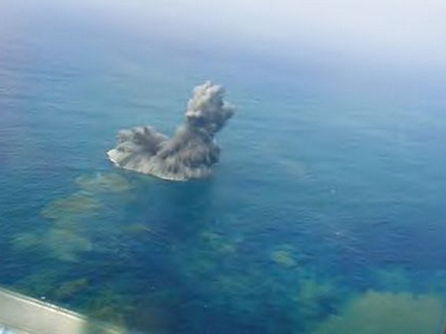 |
Figure 7. Aerial photograph of an ash plume rising from the ocean over Fukutoku-Okanoba on 3 February 2010. Photograph courtesy Japan Coast Guard. |
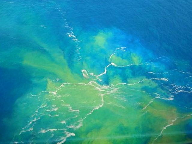 |
Figure 8. During a lull in the 3 February 2010 eruption of Fukutoku-Okanoba, some water above the summit bubbled and took on yellowish-green colors. Aerial photograph courtesy Japan Coast Guard. |
The February 2010 eruption was discovered at about 0745 by the Japan Coast Guard patrol boat Yashima on a routine survey. The crew first noticed "smoke" coming from the surface of the ocean ~ 5 km NNE of the island of Minami-Iwo-jima. The crew also heard a blast and felt its pressure wave. The Yashima continued to monitor the site from a safe distance.
Satellite imagery provided evidence that the activity persisted for at least several days. On 9 February the underwater plume appears as a complex shape N of the volcano (figure 9). Two days later, on 11 February, the plume was spread W of the volcano (figure 10).
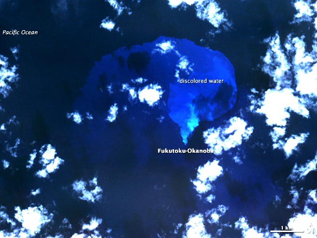 |
Figure 9. On 9 February 2010, the Advanced Spaceborne Thermal Emission and Reflection Radiometer (ASTER) on NASA's Terra satellite captured this false-color image of the ocean around Fukutoku-Okanoba volcano. Water colored by the underwater plume appears lighter in contrast to the surrounding water. The discolored water initially formed a rough V-shape N of the summit. Courtesy of NASA Earth Observatory. |
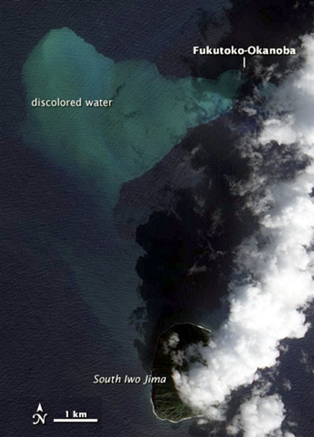 |
Figure 10. Satellite image taken 11 February 2010 of the ocean around Fukutoku-Okanoba volcano. The water colored by the plume forms a V-shape W of the volcano summit. This true-color image (enhanced for publication) was taken by the Advanced Land Imager (ALI) on NASA's EO-1 satellite. Courtesy of NASA Earth Observatory. |
JMA isssued eruption alerts for 9 March and 8 April 2010. This suggests that the eruption continued into April.
Information Contacts: Japan Meteorological Agency, 1-3-4 Otemachi, Chiyoda-ku, Tokyo 100-8122, Japan (URL: http://www.jma.go.jp/); NASA Earth Observatory (URL: http://earthobservatory.nasa.gov/).
Continued intermittent plumes of discolored water through April 2014
An explosion above the water surface from the submarine Fukutoku-Oka-no-Ba volcano was observed by the Japanese Coast Guard on 3 February 2010, and eruption alerts continued into early April of that year (BGVN 35:02). Although intermittent plumes of water discoloration after that indicated some level of ongoing activity through April 2014, the last observation of pumice on the sea surface was on 14 April 2010.
This trachyandesitic volcano is located 5 km NE of the Japanese island of Minami-Ioto, about 1,275 km S of Tokyo in the Izu-Bonin arc (figures 11 and 12). The National Catalogue of the Active Volcanoes of Japan, monthly reports by the Japan Meteorological Agency (JMA), and information tables and photographs prepared by the Japan Coast Guard (JCG) and Japan Maritime Self Defense Force (JMSDF) were the data sources for this report. A summary of the observations recorded during site visits made by Japanese authorities between April 2010 and October 2015 is given here, and additional details are provided in the table at the end of the report (table 3).
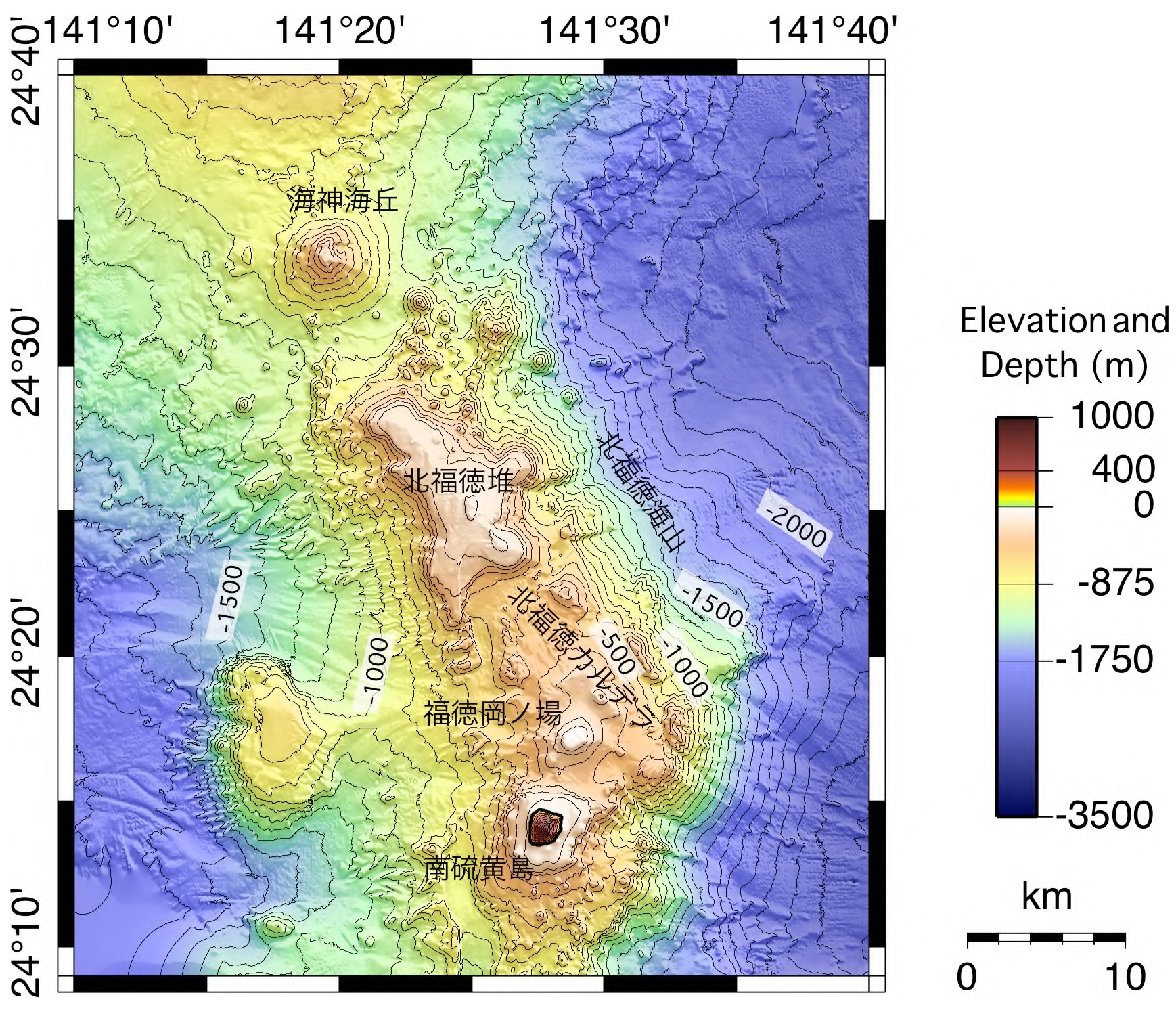 |
Figure 11. Submarine topographic map of the Fukutoku-Oka-no-Ba area. Image date not provided but it appears to pre-date the February 2010 explosion. The island above sea level at bottom is Minami-Ioto. Fukutoku-Oka-no-Ba is 5 km N and slightly E. The NW-SE elongate submarine volcano is Kita-Fukutokutai; the Kaijin Knoll is the northernmost edifice. Courtesy of Japan Coast Guard (from National Catalogue of the Active Volcanoes in Japan). |
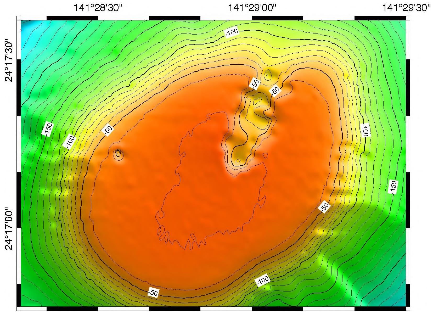 |
Figure 12. Submarine topographic map of Fukutoku-Oka-no-Ba after the February 2010 eruption (specific date not provided). Courtesy of Japan Coast Guard (from National Catalogue of the Active Volcanoes in Japan). |
Observations from February 2010 through April 2011. On 3 February 2010, a 100-m-high ash and steam eruption emerged from the sea. Floating pumice was later observed on 14 April 2010 (referred to as "floating objects" in the translation of JMA and JCG tables). Discolored water continued to be observed around the volcano for the rest of 2010. Activity from multiple vents created blue-white, milky-white, and greenish-brown plumes of discolored seawater a few hundred meters wide that drifted as far as 2,700 m. In January 2011, blue-white and creamy-colored water plumes from multiple vents drifted NE in a fan shape approximately 500 m across (figure 13). Discolored water plumes were also observed on 8 February and 12 April 2011.
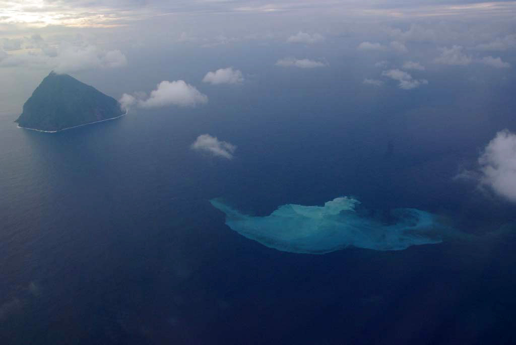 |
Figure 13. Blue-white and greenish brown discolored seawater at Fukutoku-Oka-no-Ba on 19 January 2011. The source appears to be from multiple vents. The fan shape extends about 500 m NE of the vent source. Minami-Ioto is at the upper left. Courtesy of JMSDF (Japan Maritime Self Defense Force). |
Observations from January 2012 through August 2012. Inspections of the volcano in May, July, August, and November 2011 revealed no discolored water plumes or floating objects at the site. A 150-m-diameter plume was visible again on 27 January 2012. Observations on 9 March and 19 April 2012 confirmed the continued presence of discolored water. On 11 May 2012, a 50 x 150 m milky-green-colored area was photographed by the JCG (figure 14). Additional observations of discolored water plumes were made on 13 June, 15 June, and 9 August 2012; no visits were made during September-November 2012.
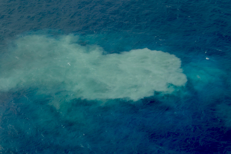 |
Figure 14. Milky-green discoloration of seawater at Fukutoku-Oka-no-Ba on 11 May 2012. The dimensions of the greenish plume are about 50 x 150 m. Courtesy of TRCGH (Third Regional Coast Guard Headquarters, JCG). |
Observations between December 2012 and April 2014. Green water was originating from multiple locations within a 1,000-m-diameter plume on 11 December 2012. Milky-white, bluish-white, and yellow-brown discoloration of seawater from multiple sources was again observed on 22 January 2013 (figure 15).
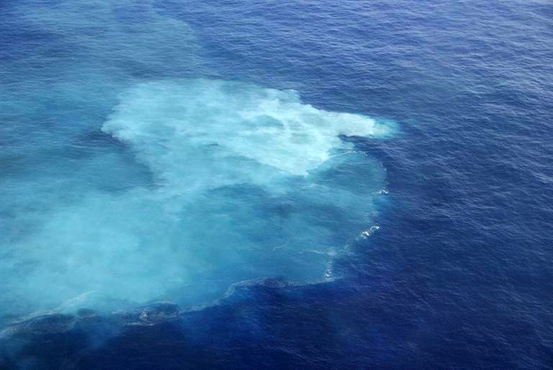 |
Figure 15. Milky-white and bluish-white discoloration of seawater from multiple vents on 22 January 2013 at Fukutoku-Oka-no-Ba. Courtesy of TRCGH (JCG); color adjusted. |
Plumes were observed twice in March (8 and 26), April (10 and 21), and on 12 May of 2013 but not during visits in June and July. They were seen again on 21 August and 27 September. No visits were made in October and November, but a 1,850-m-long plume drifting E was observed on 16 December 2013 by JMSDF. The last confirmed observations of discolored water plumes were on 29 January and 28 April 2014 by the JMSDF and JCG. They continued to visit the site nearly every month until October 2015, with no further observations of discolored water plumes. No further reports were made after October.
Table 3. Summary of observations made at Fukutoku-Oka-no-Ba between March 2010 and April 2014 by Japanese authorities. The Japan Coast Guard continued to visit the site almost every month through October 2015 with no further reports of water discoloration, and it was not mentioned after that date in monthly JMA reports. Sources: JMA*= National Catalogue of the Active Volcanoes in Japan, JMA= Monthly Summary Report, Japan Meteorological Agency, JMSDF= Japan Maritime Self Defense Force, TRCGH= Third Regional Coast Guard Headquarters, JCG=Japan Coast Guard.
| Visit Date | Discolored Water | Dimensions | Description | Source |
| Mar 2010 | Yes | -- | -- | JMA* |
| 14 Apr 2010 | Yes | 360 x 2700 m, SW | Blue-white, milky-white and pale green, multiple vents, floating objects observed | JMA*/JMSDF |
| 26 Apr 2010 | Yes | -- | Fan-like, multiple vents, blue and milky white, no floating objects observed | JMA*/TRCGH |
| 16 May 2010 | Yes | 100 m radius | Milky, multiple vents, no floating objects observed | JMA*/TRCGH |
| 04 Jun 2010 | No | -- | -- | TRCGH |
| 17 Jun 2010 | Yes | 100 x 200 m, EW | Blue-white, and green, multiple vents | JMA*/JMSDF |
| Jul 2010 | Yes | -- | -- | JMA* |
| 17 Sep 2010 | No | -- | -- | JMSDF |
| 18 Sep 2010 | No | -- | -- | JCG |
| 29 Sep 2010 | Yes | 100 x 500 m NE | Light blue, thin milky | JMA*/JCG |
| Oct 2010 | Yes | -- | -- | JMA/JCG |
| Nov 2010 | Yes | -- | -- | JMA/JCG/JMSDF |
| 18 Dec 2010 | Yes | 280 x 1,800 m | Blue-white and green, multiple active vents, drifting S | JMA/JMSDF |
| 19 Jan 2011 | Yes | 500 m NE | Multiple vents, Blue-white, milky white, greenish brown, fan shape | JMA*/JCG |
| 24 Jan 2011 | Yes | -- | -- | JMSDF |
| 28 Jan 2011 | Yes | -- | Creamy-white | JMSDF |
| 08 Feb 2011 | Yes | 50 x 2000 m NE | Multiple vents, blue-white, green | JMA*/JCG |
| 12 Apr 2011 | Yes | 100 m radius | Milky-white | JMA*/JMSDF |
| May 2011 | No | -- | -- | JMA* |
| Jul 2011 | No | -- | -- | JMA* |
| 06 Aug 2011 | No | -- | -- | TRCGH |
| 16-17 Nov 2011 | No | -- | -- | JMA*/JCG |
| 27 Jan 2012 | Yes | 150 m diameter | Milky-white, yellow-green | JMA*/TRCGH |
| 28 Jan 2012 | Yes | 100 m diameter | Milky-white, yellow-green, thin blue | TRCGH |
| 30 Jan 2012 | Yes | 60 x 300 m N | Light green, milky | TRCGH |
| 09 Mar 2012 | Yes | 50 x 200 m | Dark milky white, pale blue | JMA*/JCG |
| 19 Apr 2012 | Yes | 30 m diameter | Milky | JMA*/TRCGH |
| 11 May 2012 | Yes | 50 x 150 m; 1500 m SW | Milky; thin blue | JMA*/TRCGH |
| 16 May 2012 | Yes | -- | Slight thin white | TRCGH |
| 13 Jun 2012 | Yes | -- | Slight pale blue-white | TRCGH |
| 15 Jun 2012 | Yes | 50 m | Pale blue-white | JMA*/JMSDF |
| 09 Aug 2012 | Yes | 200 x 300 m | Multiple vents, blue-white | JMA/JMSDF |
| 23 Aug 2012 | No | -- | Poor visibility | JCG |
| 11 Dec 2012 | Yes | 1000 m diameter | Multiple vents, thin green | JMSDF |
| 22 Jan 2013 | Yes | 100 x 300 m | Multiple vents, milky-white, blue-white and light green-brown | TRCGH/JMSDF |
| 08 Mar 2013 | Yes | 1000 m [500 m] diameter | Milky white and blue | JMSDF [JMA] |
| 26 Mar 2013 | Yes | 500 x 1500 m | Milky white, pale blue and pale green | JCG |
| 10 Apr 2013 | Yes | 630 m radius | Multiple vents, green | JMA/JMSDF |
| 21 Apr 2013 | Yes | 50 m radius | Milky-white | JMA/JCG |
| 12 May 2013 | Yes | 50 x 400 m S | Milky-white | JMA/JCG |
| 25 Jun 2013 | No | -- | -- | JMA/JMSDF |
| 29 Jun 2013 | No | -- | -- | JMA/JCG |
| 17 Jul 2013 | No | -- | -- | JMA/JCG |
| 21 Aug 2013 | Yes | -- | Faint discoloration | JMA/JMSDF |
| 24 Aug 2013 | No | -- | -- | JMA/JCG |
| 27 Sep 2013 | Yes | 450 m radius | Green water and white bubbles | JMA/JMSDF |
| 16 Dec 2013 | Yes | 1850 m E | Multiple vents, green | JMA/JMSDF |
| 28 Dec 2013 | No | -- | -- | JMA/JCG |
| 13 Jan 2014 | No | -- | -- | JMA/JCG |
| 29 Jan 2014 | Yes | -- | -- | JMA/JMSDF |
| 02 Feb 2014 | No | -- | -- | JMA/JCG |
| 28 Apr 2014 | Yes | -- | -- | JMA/JCG |
Reference. Japan Meteorological Agency, 2013, National Catalogue of the Active Volcanoes in Japan (Fourth Edition, English Version), Tokyo, Japan (http://www.data.jma.go.jp/svd/vois/data/tokyo/STOCK/souran_eng/menu.htm).
Information Contacts: Japan Meteorological Agency (JMA), Otemachi, 1-3-4, Chiyoda-ku Tokyo 100-8122, Japan (URL: http://www.jma.go.jp/); Japan Coast Guard (JCG) Volcano Database, Hydrographic and Oceanographic Department, 3-1-1, Kasumigaseki, Chiyoda-ku, Tokyo 100-8932, Japan (URL: http://www1.kaiho.mlit.go.jp/GIJUTSUKOKUSAI/kaiikiDB/kaiyo24-2.htm).
Surtseyan explosions, an ash plume, and floating pumice rafts during August 2021
Fukutoku-Oka-no-ba is a submarine volcano located 5 km NE of the Japanese island of Minami-Ioto, about 1,300 km S of Tokyo. Typical activity at the site has consisted of discolored water and floating pumice. An island (called “Shin-Ioto”) was present during 1904-1905 and 1914. The 1986 eruption also built an island 600 m long and 15 m high which was later eroded away, according to information from the Japan Coast Guard. An explosion above the water surface was observed on 3 February 2010, which continued into that April (BGVN 41:06). Intermittent observations of discolored water have been made since that time, but there has been no notable eruptive activity until strong explosions in mid-August 2021 sent ash plumes to altitudes of over 12 km. Observations and monthly and special information reports come from the Japan Meteorological Agency (JMA), Japan Coast Guard (JCG) and Japan Maritime Self Defense Force (JMSDF), as well as various satellite data.
Summary of activity during May 2014-July 2021. Between May 2014 and 6 March 2016, the Japan Coast Guard intermittently visited the site, though no reports of water discoloration were made (table 4). Beginning on 7 March 2016, a pale green discoloration was noted in the water, measuring 200 x 1,000 m. Similar variations of greenish discolored water continued intermittently leading up to the eruption on 13 August 2021.
Table 4. Summary of observations made at Fukutoku-Oka-no-Ba between October 2015 and December 2021 by Japanese authorities. The Japan Coast Guard continued to visit the site intermittently, noting occasional water discoloration. Sources: JMA = Monthly Summary Report, Japan Meteorological Agency, JMSDF = Japan Maritime Self Defense Force, TRCGH = Third Regional Coast Guard Headquarters, JCG = Japan Coast Guard.
| Visit Date | Discolored Water | Dimensions | Description | Source |
| 11 Jun 2014 | No | -- | -- | MSDF |
| 13 Jun 2014 | No | -- | -- | TRCGH |
| 25 Jun 2014 | No | -- | -- | JCG |
| 12 Sep 2014 | No | -- | -- | MSDF |
| 26 Nov 2014 | No | -- | -- | TRCGH |
| 26 Dec 2014 | No | -- | -- | MSDF |
| 27 Jan 2015 | No | -- | -- | TRCGH |
| 15 Feb 2015 | No | -- | -- | TRCGH |
| 18 Feb 2015 | No | -- | -- | TRCGH |
| 14 Apr 2015 | No | -- | -- | TRCGH |
| 05 May 2015 | No | -- | -- | TRCGH |
| 26 May 2015 | No | -- | -- | TRCGH |
| 17 Aug 2015 | No | -- | -- | JCG |
| 23 Aug 2015 | No | -- | -- | TRCGH |
| 18 Oct 2015 | No | -- | -- | TRCGH |
| 07 Mar 2016 | Yes | 200 x 1,000 m | Very pale green | TRCGH |
| 29 Mar 2016 | No | -- | -- | JCG |
| 24 Dec 2016 | No | -- | -- | JCG |
| 09 Feb 2017 | No | -- | -- | MSDF |
| 07 Mar 2017 | Yes | 500 m radius | Light green, four locations vent | JMSDF |
| 24 Mar 2017 | Yes | 50 x 1,000 m NE | Yellow-green | JCG |
| 30 Mar 2017 | Yes | 700 m diameter | Pale green | MSDF |
| 24 Apr 2017 | No | -- | -- | MSDF |
| 28 Jun 2017 | No | -- | -- | JCG |
| 03 Jul 2017 | No | -- | -- | MSDF |
| 06 Oct 2017 | No | -- | -- | MSDF |
| 11 Dec 2017 | Yes | 2 x 6 km | Pale green | JCG |
| 27 Jan 2018 | Yes | 600 m diameter | Yellow-green | MSDF |
| 24 Feb 2018 | Yes | 500 x 1,000 m | Light green | MSDF |
| 27 Apr 2018 | No | -- | -- | MSDF |
| 18 Jul 2018 | No | -- | -- | JCG |
| 29 Jan 2019 | Yes | 1 km diameter | Light green | JCG |
| 19 Nov 2019 | No | -- | -- | JCG |
| 04 Feb 2020 | Yes | -- | Whitish yellow-green drifting E | JCG |
| 15 Mar 2020 | Yes | -- | Bluish-white | JCG |
| 16 Apr 2020 | Yes | -- | Yellow-green | TRCGH |
| 19 Apr 2020 | Yes | -- | Bluish white drifting E | TRCGH |
| 18 May 2020 | No | -- | -- | TRCGH |
| 19 Jun 2020 | No | -- | -- | JCG |
| 05 Apr 2021 | Yes | -- | Pale blue | JCG |
| 08 Jun 2021 | Yes | 2.4 km diameter N | Bluish-white | JCG |
| 09 Jul 2021 | Yes | -- | Bluish-white | JCG |
| 05 Aug 2021 | Yes | -- | Bluish-white drifted SSW | JCG |
| 13 Aug 2021 | -- | -- | Eruption began, though observations could not be made | TRCGH |
| 15 Aug 2021 | -- | 1 km diameter | New island with intermittent eruptions and floating pumice drifting 60 km NW | TRCGH |
| 16 Aug 2021 | Yes | -- | Gas-and-steam plume from the island, suspended pumice drifted 100 km WNW | JCG |
| 26 Aug 2021 | Yes | -- | Brown drifting W, suspended pumice | JCG |
| 12 Sep 2021 | Yes | 2 km diameter | Yellowish-green to yellowish-brown, second yellow-green discolored area 2 km ENE of the island | JCG |
| 12 Oct 2021 | Yes | -- | Brown and yellow-green drifting 5.6 km NW, white waves | JCG |
| 01 Nov 2021 | Yes | -- | Bluish-white | TRCGH |
| 11 Nov 2021 | Yes | 3 km diameter and 2 km diameter | Dark yellow-green and a second yellow-green with floating pumice | JCG |
| 29 Nov 2021 | Yes | -- | Brown to yellowish-green | TRCGH |
| 14 Dec 2021 | Yes | -- | Yellow-green and bluish-white | TRCGH |
| 27 Dec 2021 | Yes | -- | Brown and yellowish-green | JCG |
Observers on four overflights during 2020 reported visible discolored water originating from a single location, which has been frequently noted since 2005, according to JMA. On 4 February 2020 the Japan Coast Guard (JCG) conducted an overflight that confirmed pale white- to yellow-green discolored water on the ocean surface near the volcano over a distance of about 6.3 km to the W (figure 16). Discolored bluish-white water was again reported by JCG during an overflight on 15 March, though it was fainter than the previous observations. Similar faint discolored water was reported on 16 and 19 April by JCG. No further activity was reported for the rest of 2020. Similar activity was observed in overflights by JCG during the first half of 2021. Faintly discolored water (light blue to white) was observed during overflights on 5 April, 8 June, and 9 July (figure 17) according to JCG.
|
Figure 16. Photo of the white and yellow-green discolored water extending 6.3 km W from Fukutoku-Oka-no-Ba at 1351 on 4 February 2020. Courtesy of Japan Coast Guard and JMA (monthly report of activity at Fukutoku-Oka-no-Ba, February 2020). |
|
Figure 17. Photo of faintly white-blue discolored water (inside dashed circle) at Fukutoku-Oka-no-Ba at 1251 on 9 July 2021. Courtesy of Japan Coast Guard and JMA (monthly report of activity at Fukutoku-Oka-no-Ba, July 2021). |
Eruption during August 2021. During aerial observations on 5 August the JCG only saw a blue-white discolored area SSW of the volcano. A large eruption starting at 0620 on 13 August 2021 was reported by JCG, based on satellite data, and was later confirmed during an overflight that day. The resulting ash plume rose as high as 16 km altitude and had drifted 700-1,000 km W by 0900 (figure 18). Video data showed Surtseyan explosions that ejected black material above the ocean surface and drifted W. Ash plumes identified in satellite images rose 12.2-16 km altitude during 13-15 August (figure 19) and eventually reached the N part of Luzon Island in the Philippines (2,000 km SW); the height decreased after the initial ejection, though activity continued. During an overflight on 15 August the JCG observed a new island (also referred to as “Niijima”) that measured about 1 km in diameter, where gas-and-steam emissions were detected rising from its center on 16 August (figure 20). Brown discoloration of a variable shape, but with a consistent diameter of 1 km, was visible surrounding the new island. Additionally, a notable floating pumice raft was photographed extending up to 60-100 km WNW and was about 13 km wide (figure 21). A Sentinel-2 natural color satellite image captured the newly formed island, surrounded by yellow-green discolored water that extended E the next day on 17 August (figure 22).
|
Figure 18. Photo of the eruption plume at Fukutoku-Oka-no-Ba taken 90 km N of the eruption site at 1452 on 13 August 2021 (left). The plume rose to 6 km altitude. HIMAWARI satellite image shows the extent of the plume that extended W at 2000 on 13 August 2021. It reached a maximum altitude of 16 km from 0900 on 13 August to 0300 on 15 August 2021 (right). Left photo by the Third Regional Coast Guard Headquarters; courtesy of Japan Coast Guard and JMA (monthly report of activity at Fukutoku-Oka-no-Ba, August 2021). |
|
Figure 19. Photo of the plume rising above Fukutoku-Oka-no-Ba at 1256 on 15 August 2021 as floating pumice was observed drifting 60 km NW. Courtesy of Japan Coast Guard and JMA (monthly report of activity at Fukutoku-Oka-no-Ba, August 2021). |
|
Figure 20. Photo of the new island that was visible on 16 August 2021 at Fukutoku-Oka-no-Ba surrounded by discolored brown-green water extending to the W. The diameter of the island is approximately 1 km. Courtesy of Japan Coast Guard and JMA (monthly report of activity at Fukutoku-Oka-no-Ba, August 2021). |
|
Figure 21. Photo (color corrected) of the notable brown floating pumice raft from Fukutoku-Oka-no-Ba at 1508 on 16 August 2021. View is looking N with the pumice raft approximately 40 km NW of the volcano; Iwo-jima island (top right) is approximately 8 x 6 km, though it is distorted in this oblique aerial view, and located about 55 km NNW of Fukutoku-Oka-no-Ba. Courtesy of the Japan Coast Guard. |
|
Figure 22. Landsat-8 satellite image showing the appearance of discolored water and the new island emergence about 1 km in diameter at Fukutoku-Oka-no-Ba. An area of light yellow-green discoloration extended in two tendrils to the E and SE. The island to the SW of Fukutoku-Oka-no-Ba is Minami-Ioto. Landsat-8 satellite images with “True Color” rendering. Courtesy of Sentinel Hub Playground. |
A local fisherman about 5 km SSW near South Iwo Jima (Minami-Ioto) posted photos from 17 (figure 23), 20, and 22 August showing a plume rising above the volcano. On 20 August lightning was visible within the plume. Another plume was observed during 0430-0630 on 22 August and some of the floating pumice was collected by the Ocean Meteorological Observation vessel, Keikaze Maru (figure 24). The largest sample was about 40 cm in diameter; samples were mainly white, gray, and dark gray with visible bubbles, which JMA reported was similar to the samples collected from the 1986 eruption. During an overflight on 26 August observers noted that while the W part of the island remained unchanged, the E side had mostly eroded, yielding two small islands (figure 25). Though no eruptive activity was visible, gray material from the central vent was intermittently ejected to the ocean surface, and brown discolored water remained widely distributed, extending especially to the W.
|
Figure 23. Photo of the plume rising above Fukutoku-Oka-no-Ba on 17 August 2021. Courtesy of Yutaka Kosugi. |
|
Figure 24. Photos of the floating pumice that was ejected from Fukutoku-Oka-no-Ba at 0745 on 22 August 2021, collected by the Ocean Meteorological Observation vessel Keifu Maru. The pumice (light gray) was observed floating on the surface of the water (top left), which was then collected at 0745 (top right). The samples were mainly white, gray, and dark gray, and varied in size (bottom left and right). Courtesy of JMA (monthly report of activity at Fukutoku-Oka-no-Ba, August 2021). |
|
Figure 25. Photo of the new island at Fukutoku-Oka-no-Ba at 1307 on 26 August 2021 accompanied by some gray ejecta on the ocean surface. The east side of the island is partially submerged compared to initial observations made on 16 August. Yellow-green discolored water was widely observed to the W. Courtesy of Japan Coast Guard and JMA (monthly report of activity at Fukutoku-Oka-no-Ba, August 2021). |
Activity during September-December 2021. JMA reported that the yellow-green to yellow-brown discolored water continued to be widely distributed in the area during September. By 12 September an overflight showed that the E side of the island had been completely eroded and submerged (figure 26), while the length of the W side measured 1 km. Yellow-green to yellow-brown discolored water extended from the vent area to the SW, S, and SE. In addition, on 12 September an area of yellow-green to yellow-brown discolored water 2 km in diameter, independent of the initial eruption site, was observed 2 km ENE of the new island (figure 27). Floating pumice were also noted around the discolored area. As a result, JMA issued a navigation warning to nearby vessels.
|
Figure 26. Aerial photo of the island that appeared at Fukutoku-Oka-no-Ba on 16 August; the E side has been eroding away while the length of the W side (pictured) is 1 km. Yellow-brown discolored water was widely distributed around the island. The island at top left is Minami-Ioto. Photo was taken on 12 September 2021. Courtesy of Japan Coast Guard and JMA (monthly report of activity at Fukutoku-Oka-no-Ba, September 2021). |
|
Figure 27. Photo of the new 2-km-diameter area of yellow-brown discolored water (foreground) located 2 km ENE of Fukutoku-Oka-no-Ba (middle right) at 1304 on 12 September 2021. The island on the left is Minami-Ioto. Floating pumice was also noted surrounding the discolored water. Courtesy of Japan Coast Guard and JMA (monthly report of activity at Fukutoku-Oka-no-Ba, September 2021). |
Discolored water areas persisted into October, as well as floating pumice. By early October the JCG reported that the floating pumice that was ejected during the eruption in mid-August had reached the coastlines more than 1,000 km from the volcano. Pumice first reached Minamidaitou Island (1,000 km W) on 4 October (figure 28) and samples were collected and compared to those collected on 22 August. Pumice was later reported at Kitadaito Island (1,000 km W) during 5-8 October. Aerial observations reported that the W side of the new island had eroded to a third of the size it was when previously described on 12 September (figure 29). Brownish discolored water was distributed near the N shore of the W part of the island, accompanied by yellow-green discoloration, extending about 6 km NW of the volcano (figure 29). Later in the month, the pumice circled Okinawa and Maejima islands (1,400 km W) and several ports in the Kagoshima prefecture (1,300 km NW), which damaged hundreds of boats and ships, clogged harbors (figure 30), and impacted the fishing and tourism industries in several areas, which led local governments to begin removing the pumice from the water.
|
Figure 28. Photos of the floating pumice from the 13 August 2021 eruption at Fukutoku-Oka-no-Ba reaching the coast of Minamidaito Island (1,000 km W) on 4 October 2021 at 1533. Courtesy of the Minamidaito Island District Meteorological Observatory and JMA (monthly report of activity at Fukutoku-Oka-no-Ba, October 2021). |
|
Figure 29. Aerial photos of the island that appeared at Fukutoku-Oka-no-Ba on 16 August; by 12 October the length of the W side of the island measured 500 m while the E side was completely submerged (left). Brownish discolored water and floating pumice surrounded the island, as well as yellow-green discoloration that extended about 6 km NW of the volcano (right). The left picture was taken at 1308 and the right picture was taken at 1313. Courtesy of Japan Coast Guard and JMA (monthly report of activity at Fukutoku-Oka-no-Ba, October 2021). |
|
Figure 30. Photos of the floating pumice rafts from Fukutoku-Oka-no-Ba that reached the fishing port at Hentona, Kunigami (1,400 km W), a village located in the N part of Okinawa, on 29 October 2021. The length of this harbor is approximately 300 m. The distance between the harbor and the peninsula in the distance is approximately 2 km, where the pumice is seen extending along the coastline. Okinawa authorities began to remove the pumice with shovel loaders, as it was disrupting fishing and tourism. The pumice came ashore at 16 fishing ports in Okinawa and Kagoshima, damaging 40 boats. Courtesy of NHK Japan Broadcasting Corporation. |
During an overflight on 11 November white fumarolic plumes were observed rising from the N end of the island, accompanied by a blue-white band of discolored water in the S part of the island and a dark yellow-green band on the W side (figure 31). Circular discoloration was also observed on the N side of the island, along with bubbling that was seen on the ocean surface near the same location. On 27 December observers reported that the island that formed in mid-August had become smaller since 14 December and had almost eroded below the ocean surface. No eruptive activity was observed, though discolored brownish water was visible from the E end of the island. Yellow-green water and a 400-m-long string of floating pumice was circulating 5 km E of the volcano. Discolored water was visible surrounding almost the entire coast of Minami-Ioto (5 km SSW).
|
Figure 31. Aerial photos of Fukutoku-Oka-no-Ba showing white waves on the N end of the island accompanied by yellow-green discolored water on the W side of the island on 11 November 2021 at 1359 (left). A small circular bubble was observed on the ocean surface N of the island (yellow arrow). In addition, yellow-green discolored water with a diameter of about 2 km and floating pumice 20 km SE of the volcano at 1245 on 11 November was visible (right). Courtesy of Japan Coast Guard and JMA (monthly report of activity at Fukutoku-Oka-no-Ba, November 2021). |
During December the brown-yellow discoloration continued to spread around the island, which by 27 December had noticeably decreased in size since seen on 29 November. Blue-white discoloration expanded to the NNE. Brown discolored water was visible from the E side of the island as yellow-green discoloration was distributed 5 km E of the same location. On 27 December the island was covered with white waves and was surrounded by blue-green discolored water (figure 32).
|
Figure 32. Photo of the August eruption site at Fukutoku-Oka-no-Ba covered by white waves and surrounded by blue-green discolored water at 1304 on 27 December 2021. Courtesy of Japan Coast Guard. |
Satellite data. Landsat-8 satellite images were used to track the occurrence and direction of the discolored water plumes originating at the volcano (figure 33). Discoloration was detected during February 2021 and then reappeared after the start of the eruption in August. Accompanying the discolored water is the emergence of the new island that formed as a result of the eruption, which visibly decreased in size from August to October. A strong sulfur dioxide plume was captured in the Sentinel-5P satellite on 13 August 2021, drifting W as far as 350 km and rising to 3 km altitude (figure 34). The plume exceeded 18 DUs (Dobson Units).
|
Figure 33. Landsat-8 satellite images track the appearance and direction of discolored water at Fukutoku-Oka-no-Ba on clear weather days. A strong yellow-green discolored water surrounded the island on 2 September (top left), 18 September (top right), 4 October (bottom left), and 20 October (bottom right) 2021, though as time progresses the size of the island noticeably decreases. Landsat-8 satellite images with “True Color” rendering. Courtesy of Sentinel Hub Playground. |
|
Figure 34. Image of a strong sulfur dioxide plume drifting W from Fukutoku-Oka-no-Ba on 13 August 2021 as far as 350 km at an altitude of about 3 km. Data is from the Sentinel-5P satellite. Courtesy of DLR, BIRA, and ESA. |
Information Contacts: Japan Meteorological Agency (JMA), 1-3-4 Otemachi, Chiyoda-ku, Tokyo 100-8122, Japan (URL: http://www.jma.go.jp/jma/indexe.html); Japan Coast Guard (JCG) Volcano Database, Hydrographic and Oceanographic Department, 3-1-1, Kasumigaseki, Chiyoda-ku, Tokyo 100-8932, Japan (URL: http://www.kaiho.mlit.go.jp/info/kouhou/h29/index.html); NASA Global Sulfur Dioxide Monitoring Page, Atmospheric Chemistry and Dynamics Laboratory, NASA Goddard Space Flight Center (NASA/GSFC), 8800 Greenbelt Road, Goddard MD 20771, USA (URL: https://so2.gsfc.nasa.gov/); NHK Japan Broadcasting Corporation, 2-2-1 Jinnan, Shibuya-ku, Tokyo 150-8001, Japan (URL: https://www.nhk.or.jp/, https://twitter.com/nhk_news/media); Yukio Hayakawa, Gunma University, Japan, 371-8510 Gunma, Maebashi, Aramakimachi, 4-2 (URL: http://www.hayakawayukio.jp/, https://twitter.com/HayakawaYukio); Yutaka Kosugi (URL: https://twitter.com/yutaka_kosugi); German Aerospace Center (DLR), Linder Höhe, 51147 Koeln, Germany (URL: https://www.dlr.de/en); Royal Belgian Institute for Space Aeronomy (BIRA-IASB), Ringlaan 3, Avenue Circulaire 3, 1180 Brussels (URL: https://www.aeronomie.be/index.php/en); The European Space Agency (ESA), 24 rue du Général Bertrand, CS 30798, 75345 Paris CEDEX 7, France (URL: https://www.esa.int/).
This compilation of synonyms and subsidiary features may not be comprehensive. Features are organized into four major categories: Cones, Craters, Domes, and Thermal Features. Synonyms of features appear indented below the primary name. In some cases additional feature type, elevation, or location details are provided.
Synonyms |
| Shin-Iwo-jima | Sin-Io-jima | Shin-Io-jima | Minami-Iwo-jima | Hukutoku-okanoba | Sin-Iwo-zima | Fukutoku-Okanoba |
|
|
||||||||||||||||||||||||
There is data available for 10 confirmed Holocene eruptive periods.
2021 Aug 13 - 2021 Sep 12 (?) Confirmed Eruption Max VEI: 4
| Episode 1 | Eruption Episode | |||||||||||||||||||||||||||||||||||||||||||||
|---|---|---|---|---|---|---|---|---|---|---|---|---|---|---|---|---|---|---|---|---|---|---|---|---|---|---|---|---|---|---|---|---|---|---|---|---|---|---|---|---|---|---|---|---|---|
| 2021 Aug 13 - 2021 Sep 12 (?) | Evidence from Observations: Reported | ||||||||||||||||||||||||||||||||||||||||||||
|
List of 7 Events for Episode 1
| |||||||||||||||||||||||||||||||||||||||||||||
2010 Feb 3 - 2010 Apr 8 (?) Confirmed Eruption Max VEI: 1
| Episode 1 | Submarine Episode | Submarine site | ||||||||||||||||||||||||||||||||||
|---|---|---|---|---|---|---|---|---|---|---|---|---|---|---|---|---|---|---|---|---|---|---|---|---|---|---|---|---|---|---|---|---|---|---|---|
| 2010 Feb 3 - 2010 Apr 8 (?) | Evidence from Observations: Reported | ||||||||||||||||||||||||||||||||||
|
List of 5 Events for Episode 1 at Submarine site
| |||||||||||||||||||||||||||||||||||
[ 2005 Sep 11 - 2007 Feb 16 (in or after) ± 15 days ] Uncertain Eruption
| Episode 1 | Eruption Episode | |||||||||||||||
|---|---|---|---|---|---|---|---|---|---|---|---|---|---|---|---|
| 2005 Sep 11 - 2007 Feb 16 (in or after) ± 15 days | Evidence from Unknown | ||||||||||||||
|
List of 1 Events for Episode 1
| |||||||||||||||
2005 Jul 2 - 2005 Jul 21 (?) Confirmed Eruption Max VEI: 1
| Episode 1 | Eruption Episode | |||||||||||||||||||||||||
|---|---|---|---|---|---|---|---|---|---|---|---|---|---|---|---|---|---|---|---|---|---|---|---|---|---|
| 2005 Jul 2 - 2005 Jul 21 (?) | Evidence from Observations: Reported | ||||||||||||||||||||||||
|
List of 3 Events for Episode 1
| |||||||||||||||||||||||||
[ 2002 Dec 19 - 2003 Mar 11 ] Uncertain Eruption
| Episode 1 | Eruption Episode | |||||||||||||||
|---|---|---|---|---|---|---|---|---|---|---|---|---|---|---|---|
| 2002 Dec 19 - 2003 Mar 11 | Evidence from Unknown | ||||||||||||||
|
List of 1 Events for Episode 1
| |||||||||||||||
[ 2001 Oct 30 - 2002 Jun 19 ] Uncertain Eruption
| Episode 1 | Eruption Episode | |||||||||||||||
|---|---|---|---|---|---|---|---|---|---|---|---|---|---|---|---|
| 2001 Oct 30 - 2002 Jun 19 | Evidence from Unknown | ||||||||||||||
|
List of 1 Events for Episode 1
| |||||||||||||||
[ 2000 Jul 26 - 2001 Jun 13 ] Uncertain Eruption
| Episode 1 | Eruption Episode | |||||||||||||||
|---|---|---|---|---|---|---|---|---|---|---|---|---|---|---|---|
| 2000 Jul 26 - 2001 Jun 13 | Evidence from Unknown | ||||||||||||||
|
List of 1 Events for Episode 1
| |||||||||||||||
[ 1999 Sep 8 - 2000 Feb 18 ] Uncertain Eruption
| Episode 1 | Eruption Episode | |||||||||||||||
|---|---|---|---|---|---|---|---|---|---|---|---|---|---|---|---|
| 1999 Sep 8 - 2000 Feb 18 | Evidence from Unknown | ||||||||||||||
|
List of 1 Events for Episode 1
| |||||||||||||||
[ 1998 Oct 16 - 1999 Jan 12 ] Uncertain Eruption
| Episode 1 | Eruption Episode | |||||||||||||||
|---|---|---|---|---|---|---|---|---|---|---|---|---|---|---|---|
| 1998 Oct 16 - 1999 Jan 12 | Evidence from Unknown | ||||||||||||||
|
List of 1 Events for Episode 1
| |||||||||||||||
[ 1997 Nov 18 - 1998 May 21 ] Uncertain Eruption
| Episode 1 | Eruption Episode | |||||||||||||||
|---|---|---|---|---|---|---|---|---|---|---|---|---|---|---|---|
| 1997 Nov 18 - 1998 May 21 | Evidence from Unknown | ||||||||||||||
|
List of 1 Events for Episode 1
| |||||||||||||||
[ 1995 Nov 21 - 1997 Jul 28 ] Uncertain Eruption
| Episode 1 | Eruption Episode | |||||||||||||||
|---|---|---|---|---|---|---|---|---|---|---|---|---|---|---|---|
| 1995 Nov 21 - 1997 Jul 28 | Evidence from Unknown | ||||||||||||||
|
List of 1 Events for Episode 1
| |||||||||||||||
[ 1994 Jul 28 - 1994 Jul 28 ] Uncertain Eruption
| Episode 1 | Eruption Episode | |||||||||||||||
|---|---|---|---|---|---|---|---|---|---|---|---|---|---|---|---|
| 1994 Jul 28 - 1994 Jul 28 | Evidence from Unknown | ||||||||||||||
|
List of 1 Events for Episode 1
| |||||||||||||||
1992 Nov 10 - 1993 Sep 9 (?) Confirmed Eruption Max VEI: 1
| Episode 1 | Eruption Episode | |||||||||||||||||||||||||
|---|---|---|---|---|---|---|---|---|---|---|---|---|---|---|---|---|---|---|---|---|---|---|---|---|---|
| 1992 Nov 10 - 1993 Sep 9 (?) | Evidence from Observations: Reported | ||||||||||||||||||||||||
|
List of 3 Events for Episode 1
| |||||||||||||||||||||||||
[ 1991 Jul 19 - 1991 Oct 18 ] Uncertain Eruption
| Episode 1 | Eruption Episode | |||||||||||||||
|---|---|---|---|---|---|---|---|---|---|---|---|---|---|---|---|
| 1991 Jul 19 - 1991 Oct 18 | Evidence from Unknown | ||||||||||||||
|
List of 1 Events for Episode 1
| |||||||||||||||
[ 1987 Sep 4 - 1991 Feb 6 ] Uncertain Eruption
| Episode 1 | Eruption Episode | |||||||||||||||
|---|---|---|---|---|---|---|---|---|---|---|---|---|---|---|---|
| 1987 Sep 4 - 1991 Feb 6 | Evidence from Unknown | ||||||||||||||
|
List of 1 Events for Episode 1
| |||||||||||||||
1987 Jul 14 - 1987 Aug 30 (?) Confirmed Eruption Max VEI: 0
| Episode 1 | Eruption Episode | ||||||||||||||||||||
|---|---|---|---|---|---|---|---|---|---|---|---|---|---|---|---|---|---|---|---|---|
| 1987 Jul 14 - 1987 Aug 30 (?) | Evidence from Observations: Reported | |||||||||||||||||||
|
List of 2 Events for Episode 1
| ||||||||||||||||||||
[ 1986 Apr 7 - 1987 Jun 26 ] Uncertain Eruption
| Episode 1 | Eruption Episode | |||||||||||||||
|---|---|---|---|---|---|---|---|---|---|---|---|---|---|---|---|
| 1986 Apr 7 - 1987 Jun 26 | Evidence from Unknown | ||||||||||||||
|
List of 1 Events for Episode 1
| |||||||||||||||
1986 Jan 18 - 1986 Mar 28 (?) Confirmed Eruption Max VEI: 2
| Episode 1 | Eruption Episode | |||||||||||||||||||||||||||||||||||
|---|---|---|---|---|---|---|---|---|---|---|---|---|---|---|---|---|---|---|---|---|---|---|---|---|---|---|---|---|---|---|---|---|---|---|---|
| 1986 Jan 18 - 1986 Mar 28 (?) | Evidence from Observations: Reported | ||||||||||||||||||||||||||||||||||
|
List of 5 Events for Episode 1
| |||||||||||||||||||||||||||||||||||
[ 1976 Aug 2 - 1985 Dec 23 ] Uncertain Eruption
| Episode 1 | Eruption Episode | |||||||||||||||
|---|---|---|---|---|---|---|---|---|---|---|---|---|---|---|---|
| 1976 Aug 2 - 1985 Dec 23 | Evidence from Unknown | ||||||||||||||
|
List of 1 Events for Episode 1
| |||||||||||||||
1974 Dec 24 - 1975 Nov 13 (?) Confirmed Eruption Max VEI: 2
| Episode 1 | Eruption Episode | ||||||||||||||||||||
|---|---|---|---|---|---|---|---|---|---|---|---|---|---|---|---|---|---|---|---|---|
| 1974 Dec 24 - 1975 Nov 13 (?) | Evidence from Observations: Reported | |||||||||||||||||||
|
List of 2 Events for Episode 1
| ||||||||||||||||||||
1973 Dec 18 - 1974 Feb 16 Confirmed Eruption Max VEI: 2
| Episode 1 | Eruption Episode | 3.8 km NNE of Minami-Iwo-jima | ||||||||||||||||||||||||
|---|---|---|---|---|---|---|---|---|---|---|---|---|---|---|---|---|---|---|---|---|---|---|---|---|---|
| 1973 Dec 18 - 1974 Feb 16 | Evidence from Observations: Reported | ||||||||||||||||||||||||
|
List of 3 Events for Episode 1 at 3.8 km NNE of Minami-Iwo-jima
| |||||||||||||||||||||||||
[ 1972 Oct 1 - 1972 Oct 1 ] Uncertain Eruption
| Episode 1 | Eruption Episode | |||||||||||||||
|---|---|---|---|---|---|---|---|---|---|---|---|---|---|---|---|
| 1972 Oct 1 - 1972 Oct 1 | Evidence from Unknown | ||||||||||||||
|
List of 1 Events for Episode 1
| |||||||||||||||
[ 1968 Aug 14 - 1968 Aug 20 ] Uncertain Eruption
| Episode 1 | Eruption Episode | |||||||||||||||
|---|---|---|---|---|---|---|---|---|---|---|---|---|---|---|---|
| 1968 Aug 14 - 1968 Aug 20 | Evidence from Unknown | ||||||||||||||
|
List of 1 Events for Episode 1
| |||||||||||||||
[ 1968 Feb 9 - 1968 Feb 9 ] Uncertain Eruption
| Episode 1 | Eruption Episode | |||||||||||||||
|---|---|---|---|---|---|---|---|---|---|---|---|---|---|---|---|
| 1968 Feb 9 - 1968 Feb 9 | Evidence from Unknown | ||||||||||||||
|
List of 1 Events for Episode 1
| |||||||||||||||
[ 1967 Jul 1 - 1967 Jul 1 ] Uncertain Eruption
| Episode 1 | Eruption Episode | |||||||||||||||
|---|---|---|---|---|---|---|---|---|---|---|---|---|---|---|---|
| 1967 Jul 1 - 1967 Jul 1 | Evidence from Unknown | ||||||||||||||
|
List of 1 Events for Episode 1
| |||||||||||||||
[ 1963 Oct 27 ] Uncertain Eruption
| Episode 1 | Eruption Episode | |||||||||||||||
|---|---|---|---|---|---|---|---|---|---|---|---|---|---|---|---|
| 1963 Oct 27 - Unknown | Evidence from Unknown | ||||||||||||||
|
List of 1 Events for Episode 1
| |||||||||||||||
[ 1962 Jul 1 - 1962 Oct 1 ] Uncertain Eruption
| Episode 1 | Eruption Episode | |||||||||||||||
|---|---|---|---|---|---|---|---|---|---|---|---|---|---|---|---|
| 1962 Jul 1 - 1962 Oct 1 | Evidence from Unknown | ||||||||||||||
|
List of 1 Events for Episode 1
| |||||||||||||||
[ 1960 Jul 1 - 1960 Sep 1 ] Uncertain Eruption
| Episode 1 | Eruption Episode | |||||||||||||||
|---|---|---|---|---|---|---|---|---|---|---|---|---|---|---|---|
| 1960 Jul 1 - 1960 Sep 1 | Evidence from Unknown | ||||||||||||||
|
List of 1 Events for Episode 1
| |||||||||||||||
[ 1959 Jul 1 - 1959 Oct 1 ] Uncertain Eruption
| Episode 1 | Eruption Episode | |||||||||||||||
|---|---|---|---|---|---|---|---|---|---|---|---|---|---|---|---|
| 1959 Jul 1 - 1959 Oct 1 | Evidence from Unknown | ||||||||||||||
|
List of 1 Events for Episode 1
| |||||||||||||||
[ 1958 Jul 1 - 1958 Oct 1 ] Uncertain Eruption
| Episode 1 | Eruption Episode | |||||||||||||||
|---|---|---|---|---|---|---|---|---|---|---|---|---|---|---|---|
| 1958 Jul 1 - 1958 Oct 1 | Evidence from Unknown | ||||||||||||||
|
List of 1 Events for Episode 1
| |||||||||||||||
[ 1956 Apr 1 - 1956 May 1 ] Uncertain Eruption
| Episode 1 | Eruption Episode | |||||||||||||||
|---|---|---|---|---|---|---|---|---|---|---|---|---|---|---|---|
| 1956 Apr 1 - 1956 May 1 | Evidence from Unknown | ||||||||||||||
|
List of 1 Events for Episode 1
| |||||||||||||||
[ 1955 Apr 1 - 1955 Apr 1 ] Uncertain Eruption
| Episode 1 | Eruption Episode | |||||||||||||||
|---|---|---|---|---|---|---|---|---|---|---|---|---|---|---|---|
| 1955 Apr 1 - 1955 Apr 1 | Evidence from Unknown | ||||||||||||||
|
List of 1 Events for Episode 1
| |||||||||||||||
[ 1954 Feb 4 ± 4 days ] Uncertain Eruption
| Episode 1 | Eruption Episode | ||||||||||||||||||||
|---|---|---|---|---|---|---|---|---|---|---|---|---|---|---|---|---|---|---|---|---|
| 1954 Feb 4 ± 4 days - Unknown | Evidence from Unknown | |||||||||||||||||||
|
List of 2 Events for Episode 1
| ||||||||||||||||||||
[ 1953 Dec 1 - 1953 Dec 1 ] Uncertain Eruption
| Episode 1 | Eruption Episode | |||||||||||||||
|---|---|---|---|---|---|---|---|---|---|---|---|---|---|---|---|
| 1953 Dec 1 - 1953 Dec 1 | Evidence from Unknown | ||||||||||||||
|
List of 1 Events for Episode 1
| |||||||||||||||
[ 1952 Jun 20 - 1952 Jun 20 ] Uncertain Eruption
| Episode 1 | Eruption Episode | |||||||||||||||
|---|---|---|---|---|---|---|---|---|---|---|---|---|---|---|---|
| 1952 Jun 20 - 1952 Jun 20 | Evidence from Unknown | ||||||||||||||
|
List of 1 Events for Episode 1
| |||||||||||||||
[ 1950 Feb 1 - 1950 Feb 1 ] Uncertain Eruption
| Episode 1 | Eruption Episode | |||||||||||||||
|---|---|---|---|---|---|---|---|---|---|---|---|---|---|---|---|
| 1950 Feb 1 - 1950 Feb 1 | Evidence from Unknown | ||||||||||||||
|
List of 1 Events for Episode 1
| |||||||||||||||
1914 Jan 13 - 1914 Aug 21 (in or after) Confirmed Eruption Max VEI: 3
| Episode 1 | Eruption Episode | Shin-Iwo-jima | ||||||||||||||||||||||||||||||||||
|---|---|---|---|---|---|---|---|---|---|---|---|---|---|---|---|---|---|---|---|---|---|---|---|---|---|---|---|---|---|---|---|---|---|---|---|
| 1914 Jan 13 - 1914 Aug 21 (in or after) | Evidence from Observations: Reported | ||||||||||||||||||||||||||||||||||
|
List of 5 Events for Episode 1 at Shin-Iwo-jima
| |||||||||||||||||||||||||||||||||||
1904 Nov 14 - 1905 May 16 (?) Confirmed Eruption Max VEI: 3
| Episode 1 | Eruption Episode | Shin-Iwo-jima | |||||||||||||||||||||||||||||
|---|---|---|---|---|---|---|---|---|---|---|---|---|---|---|---|---|---|---|---|---|---|---|---|---|---|---|---|---|---|---|
| 1904 Nov 14 - 1905 May 16 (?) | Evidence from Observations: Reported | |||||||||||||||||||||||||||||
|
List of 4 Events for Episode 1 at Shin-Iwo-jima
| ||||||||||||||||||||||||||||||
There is no Deformation History data available for Fukutoku-Oka-no-Ba.
There is no Emissions History data available for Fukutoku-Oka-no-Ba.
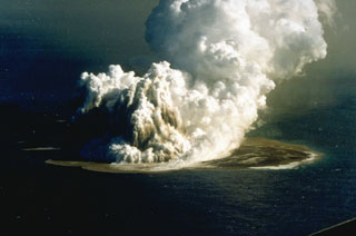 An eruption plume rising 3-4 km above Fukutoku-Oka-no-ba was witnessed from fishing boats on 18 Janaury 1986. A 4-km plume was detected by radar the following day. On 20 January a new island formed (seen here to the right of the eruption plume). The island reached maximum dimensions of 400 x 600 m, with a height of 15 m. Frequent strong explosions continued on 21 January, the day of this photo, and decreased in intensity that afternoon. Explosive activity ended by the next morning, and the island eroded to below sea level by 8 March.
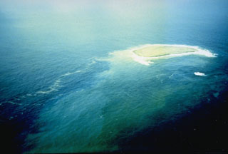 This photo shows a new island at the Fukutoku-Oka-no-ba submarine volcano on 28 January 1986. It was first seen on 20 January, four days after fishing boats observed an eruption plume rising from the ocean. The island reached a maximum size of 400 x 600 m, with a height of 15 m. By 22 January explosive activity had ceased, and the island was completely eroded away by 8 March.
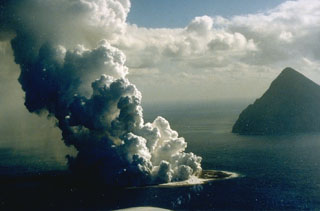 Fukutoku-Oka-no-ba is a submarine volcano located 5 km NE of Minami-Iwojima island (right). Water discoloration is frequently observed near the volcano and several ephemeral islands formed in the 20th century. The first of these created Shin-Iwojima in 1904, and the island seen in this 21 January 1986 photo; wave erosion removed the island by 8 March.
 The topographic high (red) at the top of this bathymetric image is Kita-Fukutokutai submarine volcano. It is halfway between Iwojima and Minami-Iwojima islands, NW of Fukutoku-Okanoba submarine volcano (center; north of Minami-Iwojima). Water discoloration was reported several times beginning in 1937 at Kita-Fukutokutai, and in 1988 a fishing boat reported an eruption column about 100 m high, although the report was not confirmed at the time.
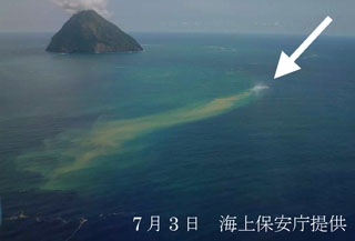 Fukutoku-Oka-no-ba on 3 July 2005 from the NE shows a plume of debris and discoloration extending from the arrow. On the previous day a white plume was observed, which later reached about 1 km above the ocean surface. Numerous large and steaming floating blocks were seen at mid-day on 3 July. The island in the background is Shin-Iwojima.
The maps shown below have been scanned from the GVP map archives and include the volcano on this page. Clicking on the small images will load the full 300 dpi map. Very small-scale maps (such as world maps) are not included. The maps database originated over 30 years ago, but was only recently updated and connected to our main database. We welcome users to tell us if they see incorrect information or other problems with the maps; please use the Contact GVP link at the bottom of the page to send us email.
The following 1 samples associated with this volcano can be found in the Smithsonian's NMNH Department of Mineral Sciences collections, and may be availble for research (contact the Rock and Ore Collections Manager). Catalog number links will open a window with more information.
| Catalog Number | Sample Description | Lava Source | Collection Date |
|---|---|---|---|
| NMNH 116252 | Pumice | -- | 20 Jan 1986 |
| Copernicus Browser | The Copernicus Browser replaced the Sentinel Hub Playground browser in 2023, to provide access to Earth observation archives from the Copernicus Data Space Ecosystem, the main distribution platform for data from the EU Copernicus missions. |
| MIROVA | Middle InfraRed Observation of Volcanic Activity (MIROVA) is a near real time volcanic hot-spot detection system based on the analysis of MODIS (Moderate Resolution Imaging Spectroradiometer) data. In particular, MIROVA uses the Middle InfraRed Radiation (MIR), measured over target volcanoes, in order to detect, locate and measure the heat radiation sourced from volcanic activity. |
| MODVOLC Thermal Alerts | Using infrared satellite Moderate Resolution Imaging Spectroradiometer (MODIS) data, scientists at the Hawai'i Institute of Geophysics and Planetology, University of Hawai'i, developed an automated system called MODVOLC to map thermal hot-spots in near real time. For each MODIS image, the algorithm automatically scans each 1 km pixel within it to check for high-temperature hot-spots. When one is found the date, time, location, and intensity are recorded. MODIS looks at every square km of the Earth every 48 hours, once during the day and once during the night, and the presence of two MODIS sensors in space allows at least four hot-spot observations every two days. Each day updated global maps are compiled to display the locations of all hot spots detected in the previous 24 hours. There is a drop-down list with volcano names which allow users to 'zoom-in' and examine the distribution of hot-spots at a variety of spatial scales. |
|
WOVOdat
Single Volcano View Temporal Evolution of Unrest Side by Side Volcanoes |
WOVOdat is a database of volcanic unrest; instrumentally and visually recorded changes in seismicity, ground deformation, gas emission, and other parameters from their normal baselines. It is sponsored by the World Organization of Volcano Observatories (WOVO) and presently hosted at the Earth Observatory of Singapore.
GVMID Data on Volcano Monitoring Infrastructure The Global Volcano Monitoring Infrastructure Database GVMID, is aimed at documenting and improving capabilities of volcano monitoring from the ground and space. GVMID should provide a snapshot and baseline view of the techniques and instrumentation that are in place at various volcanoes, which can be use by volcano observatories as reference to setup new monitoring system or improving networks at a specific volcano. These data will allow identification of what monitoring gaps exist, which can be then targeted by remote sensing infrastructure and future instrument deployments. |
| Volcanic Hazard Maps | The IAVCEI Commission on Volcanic Hazards and Risk has a Volcanic Hazard Maps database designed to serve as a resource for hazard mappers (or other interested parties) to explore how common issues in hazard map development have been addressed at different volcanoes, in different countries, for different hazards, and for different intended audiences. In addition to the comprehensive, searchable Volcanic Hazard Maps Database, this website contains information about diversity of volcanic hazard maps, illustrated using examples from the database. This site is for educational purposes related to volcanic hazard maps. Hazard maps found on this website should not be used for emergency purposes. For the most recent, official hazard map for a particular volcano, please seek out the proper institutional authorities on the matter. |
| IRIS seismic stations/networks | Incorporated Research Institutions for Seismology (IRIS) Data Services map showing the location of seismic stations from all available networks (permanent or temporary) within a radius of 0.18° (about 20 km at mid-latitudes) from the given location of Fukutoku-Oka-no-Ba. Users can customize a variety of filters and options in the left panel. Note that if there are no stations are known the map will default to show the entire world with a "No data matched request" error notice. |
| UNAVCO GPS/GNSS stations | Geodetic Data Services map from UNAVCO showing the location of GPS/GNSS stations from all available networks (permanent or temporary) within a radius of 20 km from the given location of Fukutoku-Oka-no-Ba. Users can customize the data search based on station or network names, location, and time window. Requires Adobe Flash Player. |
| DECADE Data | The DECADE portal, still in the developmental stage, serves as an example of the proposed interoperability between The Smithsonian Institution's Global Volcanism Program, the Mapping Gas Emissions (MaGa) Database, and the EarthChem Geochemical Portal. The Deep Earth Carbon Degassing (DECADE) initiative seeks to use new and established technologies to determine accurate global fluxes of volcanic CO2 to the atmosphere, but installing CO2 monitoring networks on 20 of the world's 150 most actively degassing volcanoes. The group uses related laboratory-based studies (direct gas sampling and analysis, melt inclusions) to provide new data for direct degassing of deep earth carbon to the atmosphere. |
| Large Eruptions of Fukutoku-Oka-no-Ba | Information about large Quaternary eruptions (VEI >= 4) is cataloged in the Large Magnitude Explosive Volcanic Eruptions (LaMEVE) database of the Volcano Global Risk Identification and Analysis Project (VOGRIPA). |
| EarthChem | EarthChem develops and maintains databases, software, and services that support the preservation, discovery, access and analysis of geochemical data, and facilitate their integration with the broad array of other available earth science parameters. EarthChem is operated by a joint team of disciplinary scientists, data scientists, data managers and information technology developers who are part of the NSF-funded data facility Integrated Earth Data Applications (IEDA). IEDA is a collaborative effort of EarthChem and the Marine Geoscience Data System (MGDS). |

