

AVO reported that earthquake activity near Tanaga had decreased in both rate and magnitude. The rate of earthquakes had been about three events per day during the previous three weeks, much lower than the 150 events per day recorded during the peak of the swarm in mid-March. Recent satellite images did not indicate any deformation on the island and no other signs of volcanic unrest had been detected. On 18 July the Volcano Alert Level was lowered to Normal (the lowest level on a four-level scale) and the Aviation Color Code was lowered to Green (the lowest color on a four-color scale).
Source: US Geological Survey Alaska Volcano Observatory (AVO)
Weak, moderate depth seismicity
The Alaska Volcano Observatory (AVO) detected an increase in seismic activity beneath Tanaga beginning on 1 October 2005, with 15-68 earthquakes occurring daily. Previously, less than one earthquake had occurred per month since the seismic network was installed in 2003. The earthquakes were centered roughly 2 km NE of the summit at depths of 10-20 km below sea level. The largest event was M 1.7, with most earthquakes at M 0.5-1.5. Tanaga was at Concern Color Code Green on 5 October.
During 5-7 October, there was a marked increase in the rate of seismicity. The located earthquakes ranged in magnitude from 0.5 to 1.9 and ranged in depth from 6 to 12 km beneath the summit. In response, AVO raised the Concern Color Code to Yellow on 7 October. AVO reported that while the seismic activity represented a significant increase in rate, the size, depth, and character of the events were not indicative of imminent eruptive activity.
Elevated seismic activity below the young vents continued through 28 October 2005, although the rate of small earthquakes decreased slightly from the previous week. The activity that began on 1 October was at the highest level recorded since the seismic network was installed in 2003, so the Concern Color Code remained at Yellow. An unusual seismic signal on 17 October that persisted for several minutes may have been a landslide or small phreatic explosion, but satellite images detected no airborne ash. Beginning on 24 October, AVO observed weak, nearly continuous volcanic tremor in the vicinity of Takawangha volcano of the Tanaga volcano cluster. This was the first recorded tremor of this type. The daily number of small earthquakes continued to diminish from its peak in early October, but stayed above background levels.
AVO reported on 25 November 2005 that for several weeks seismicity beneath young volcanic vents on Tanaga Island decreased significantly from levels recorded in early October. Satellite images showed no anomalous temperatures or evidence of ash emissions. AVO reported that, based on the decrease in earthquake counts and frequency of tremor episodes, the likelihood of an eruption had diminished. Therefore, AVO downgraded the Concern Color Code to Green. According to AVO, the most recent eruptive activity at Tanaga was a lava flow observed in 1914.
Information Contacts: Alaska Volcano Observatory (AVO), a cooperative program of the U.S. Geological Survey, 4200 University Drive, Anchorage, AK 99508-4667, USA (URL: http://www.avo.alaska.edu/), Geophysical Institute, University of Alaska, PO Box 757320, Fairbanks, AK 99775-7320, USA, and Alaska Division of Geological & Geophysical Surveys, 794 University Ave., Suite 200, Fairbanks, AK 99709, USA.
2023: March
| July
2021: March
| April
2005: October
| November
AVO reported that earthquake activity near Tanaga had decreased in both rate and magnitude. The rate of earthquakes had been about three events per day during the previous three weeks, much lower than the 150 events per day recorded during the peak of the swarm in mid-March. Recent satellite images did not indicate any deformation on the island and no other signs of volcanic unrest had been detected. On 18 July the Volcano Alert Level was lowered to Normal (the lowest level on a four-level scale) and the Aviation Color Code was lowered to Green (the lowest color on a four-color scale).
Source: US Geological Survey Alaska Volcano Observatory (AVO)
AVO reported that earthquake activity near Tanaga had decreased in both rate and magnitude from the peak of the swarm recorded during 9-11 March. More than 800 earthquakes, including multiple M2 and above events, were detected beneath Tanaga Island at depths less than 9 km below sea level during 11-17 March. The decline in activity decreased the potential for an eruption, so AVO lowered the Volcano Alert Level to Advisory (the second lowest level on a four-level scale) and the Aviation Color Code to Yellow (the second lowest color on a four-color scale) on 16 March. The Volcano Alert Level and Aviation Color Code for Takawangha (8 km E) were also lowered to the same level. Several M 2 and higher earthquakes were detected during 17-18 March, in addition to numerous smaller events. Earthquake activity persisted through 20 March.
Source: US Geological Survey Alaska Volcano Observatory (AVO)
AVO reported that earthquake activity near Tanaga began to increase on 4 March with events up to the M2 range and located 9-18 km deep. Seismicity again increased around 1330 on 7 March and by 2045 earthquakes were occurring at a rate of 2-3 per minute. AVO raised the Aviation Color Code to Yellow (the second lowest level on a four-color scale) and the Volcano Alert Level to Advisory the second lowest level on a four-level scale). The seismicity was sustained during 8-9 March and had shallowed to depths less than about 6 km, indicating increased potential for an eruption. AVO raised the Volcano Alert Level to Watch and the Aviation Color Code to Orange, the highest levels, at 1719 on 9 March. Seismicity was also elevated at Takawangha, 8 km E; both volcanoes are located on Tanaga Island. It was uncertain which volcano would erupt, if an eruption were to occur, so the Volcano Alert Level and Aviation Color Code for Takawangha were also raised to the same level. Earthquakes beneath Tanaga Island occurred at a rate of up to several per minute, with the largest event during 8-9 March, a M3.9, located under Tanaga Volcano. Earthquakes beneath Tanaga and Takawangha occurred at a rate of up to several events per minute during 10-11 March and at a slightly reduced rate during 12-14 March. The earthquakes had magnitudes up to around 4.
Source: US Geological Survey Alaska Volcano Observatory (AVO)
At 2215 on 7 March AVO raised the Aviation Color Code for Tanaga to Yellow and the Volcano Alert Level to Advisory due to increased seismicity. Earlier that afternoon, starting at about 1330, seismicity began to increase and by around 2045 earthquakes were occurring at a rate of 2-3 per minute. The events were located at shallow depths and the largest events were M2-3.
Source: US Geological Survey Alaska Volcano Observatory (AVO)
AVO reported that communication was reestablished with two seismic stations on Tanaga, making a total of four operational stations. On 19 April AVO changed both the Aviation Color Code and the Volcano Alert Level to Green and Normal, respectively, reflecting the resumption of seismically monitoring unrest.
Source: US Geological Survey Alaska Volcano Observatory (AVO)
AVO reported a loss of operation and communication with all but two seismic stations on Tanaga, likely caused by snow cover. Both the Aviation Color Code and the Volcano Alert Level were changed to Unassigned, reflecting the inability to locate earthquakes to detect unrest. Monitoring will continue with the remaining seismic stations, regional infrasound networks, lightning detection, and satellite images.
Source: US Geological Survey Alaska Volcano Observatory (AVO)
AVO reported on 25 November that for several weeks seismicity beneath young volcanic vents on Tanaga Island decreased significantly from levels recorded in early October. Satellite images of the island showed no anomalous temperatures or evidence of ash emissions. AVO reported that based on the decrease in earthquake counts and frequency of tremor episodes, the likelihood of an eruption had diminished. Therefore, AVO downgraded the Concern Color Code from Yellow to Green.
Source: US Geological Survey Alaska Volcano Observatory (AVO)
Elevated seismicity below young volcanic vents on Tanaga Island continued during 21-28 October. Beginning on 24 October, AVO observed weak, nearly continuous volcanic tremor in the vicinity of Takawangha volcano of the Tanaga volcano cluster. This was the first time that tremor of this sort had been observed in the volcanic cluster since the seismic network was installed in 2003. The daily number of small earthquakes continued to diminish from its peak in early October, but stayed above background levels. Tanaga remained at Concern Color Code Yellow.
Source: US Geological Survey Alaska Volcano Observatory (AVO)
Elevated seismic activity below young volcanic vents on Tanaga Island continued during 14-21 October, although the rate of small earthquakes reduced in comparison to peak values during early October. An unusual, several minute-long seismic signal on 17 October may have been a landslide or small phreatic explosion, but satellite images detected no airborne ash. The activity that began at Tanaga on 1 October was at the highest level recorded since the seismic network was installed in 2003, so the Concern Color Code remained at Yellow.
Source: US Geological Survey Alaska Volcano Observatory (AVO)
Elevated seismic activity below young volcanic vents on Tanaga Island continued during 7-14 October, although the rate of small earthquakes reduced slightly in comparison to the previous week. The activity that began at Tanaga on 1 October was at the highest level recorded since the seismic network was installed in 2003, so the Concern Color Code remained at Yellow.
Source: US Geological Survey Alaska Volcano Observatory (AVO)
AVO detected an increase in seismic activity beneath Tanaga beginning on 1 October, with 15-68 earthquakes occurring daily. Previously, less than one earthquake had occurred per month since the seismic network was installed in 2003. The earthquakes were centered roughly 2 km NE of the volcano's summit at depths of 10-20 km below sea level. The largest event was M 1.7, with most earthquakes between M 0.5-1.5. Tanaga was at Concern Color Code Green on 5 October. During 5-7 October, there was a marked increase in the rate of seismicity. The located earthquakes ranged in magnitude from 0.5 to 1.9 and ranged in depth from 6 to 12 km beneath the volcano's summit. In response to the observed changes in seismic activity, AVO raised the Concern Color Code to Yellow on 7 October. AVO reported that while the seismic activity represented a significant increase in rate, the size, depths and character of the events were not indicative of imminent eruptive activity.
Source: US Geological Survey Alaska Volcano Observatory (AVO)
Reports are organized chronologically and indexed below by Month/Year (Publication Volume:Number), and include a one-line summary. Click on the index link or scroll down to read the reports.
Weak, moderate depth seismicity
The Alaska Volcano Observatory (AVO) detected an increase in seismic activity beneath Tanaga beginning on 1 October 2005, with 15-68 earthquakes occurring daily. Previously, less than one earthquake had occurred per month since the seismic network was installed in 2003. The earthquakes were centered roughly 2 km NE of the summit at depths of 10-20 km below sea level. The largest event was M 1.7, with most earthquakes at M 0.5-1.5. Tanaga was at Concern Color Code Green on 5 October.
During 5-7 October, there was a marked increase in the rate of seismicity. The located earthquakes ranged in magnitude from 0.5 to 1.9 and ranged in depth from 6 to 12 km beneath the summit. In response, AVO raised the Concern Color Code to Yellow on 7 October. AVO reported that while the seismic activity represented a significant increase in rate, the size, depth, and character of the events were not indicative of imminent eruptive activity.
Elevated seismic activity below the young vents continued through 28 October 2005, although the rate of small earthquakes decreased slightly from the previous week. The activity that began on 1 October was at the highest level recorded since the seismic network was installed in 2003, so the Concern Color Code remained at Yellow. An unusual seismic signal on 17 October that persisted for several minutes may have been a landslide or small phreatic explosion, but satellite images detected no airborne ash. Beginning on 24 October, AVO observed weak, nearly continuous volcanic tremor in the vicinity of Takawangha volcano of the Tanaga volcano cluster. This was the first recorded tremor of this type. The daily number of small earthquakes continued to diminish from its peak in early October, but stayed above background levels.
AVO reported on 25 November 2005 that for several weeks seismicity beneath young volcanic vents on Tanaga Island decreased significantly from levels recorded in early October. Satellite images showed no anomalous temperatures or evidence of ash emissions. AVO reported that, based on the decrease in earthquake counts and frequency of tremor episodes, the likelihood of an eruption had diminished. Therefore, AVO downgraded the Concern Color Code to Green. According to AVO, the most recent eruptive activity at Tanaga was a lava flow observed in 1914.
Information Contacts: Alaska Volcano Observatory (AVO), a cooperative program of the U.S. Geological Survey, 4200 University Drive, Anchorage, AK 99508-4667, USA (URL: http://www.avo.alaska.edu/), Geophysical Institute, University of Alaska, PO Box 757320, Fairbanks, AK 99775-7320, USA, and Alaska Division of Geological & Geophysical Surveys, 794 University Ave., Suite 200, Fairbanks, AK 99709, USA.
This compilation of synonyms and subsidiary features may not be comprehensive. Features are organized into four major categories: Cones, Craters, Domes, and Thermal Features. Synonyms of features appear indented below the primary name. In some cases additional feature type, elevation, or location details are provided.
Cones |
||||
| Feature Name | Feature Type | Elevation | Latitude | Longitude |
| East Tanaka | Stratovolcano | 1584 m | 51° 53' 0" N | 178° 7' 0" W |
| Sajaka | Stratovolcano | 1354 m | 51° 52' 30" N | 178° 11' 0" W |
| Sajaka Two | Cone | 1312 m | 51° 52' 30" N | 178° 12' 0" W |
|
|
||||||||||||||||||||||||||
There is data available for 6 confirmed Holocene eruptive periods.
1914 Confirmed Eruption Max VEI: 0
| Episode 1 | Eruption Episode | ||||||||||||||||||||
|---|---|---|---|---|---|---|---|---|---|---|---|---|---|---|---|---|---|---|---|---|
| 1914 - Unknown | Evidence from Observations: Reported | |||||||||||||||||||
|
List of 2 Events for Episode 1
| ||||||||||||||||||||
1829 Confirmed Eruption
| Episode 1 | Eruption Episode | ||||||||||||||||||||
|---|---|---|---|---|---|---|---|---|---|---|---|---|---|---|---|---|---|---|---|---|
| 1829 - Unknown | Evidence from Observations: Reported | |||||||||||||||||||
|
List of 2 Events for Episode 1
| ||||||||||||||||||||
[ 1791 Jun 7 ] Uncertain Eruption
| Episode 1 | Eruption Episode | |||||||||||||||
|---|---|---|---|---|---|---|---|---|---|---|---|---|---|---|---|
| 1791 Jun 7 - Unknown | Evidence from Unknown | ||||||||||||||
|
List of 1 Events for Episode 1
| |||||||||||||||
[ 1763 - 1770 ] Uncertain Eruption
| Episode 1 | Eruption Episode | ||||
|---|---|---|---|---|
| 1763 - 1770 | Evidence from Unknown | |||
1550 (?) Confirmed Eruption
| Episode 1 | Eruption Episode | Tanaga, Sajaka Two | |||||||||||||||||||
|---|---|---|---|---|---|---|---|---|---|---|---|---|---|---|---|---|---|---|---|---|
| 1550 (?) - Unknown | Evidence from Isotopic: 14C (uncalibrated) | |||||||||||||||||||
|
List of 2 Events for Episode 1 at Tanaga, Sajaka Two
| ||||||||||||||||||||
1050 (?) Confirmed Eruption
| Episode 1 | Eruption Episode | Tanaga | |||||||||||||||||||
|---|---|---|---|---|---|---|---|---|---|---|---|---|---|---|---|---|---|---|---|---|
| 1050 (?) - Unknown | Evidence from Isotopic: 14C (uncalibrated) | |||||||||||||||||||
|
List of 2 Events for Episode 1 at Tanaga
| ||||||||||||||||||||
0550 BCE ± 2500 years Confirmed Eruption
| Episode 1 | Eruption Episode | Sajaka One | |||||||||||||||||||||||||||||
|---|---|---|---|---|---|---|---|---|---|---|---|---|---|---|---|---|---|---|---|---|---|---|---|---|---|---|---|---|---|---|
| 0550 BCE ± 2500 years - Unknown | Evidence from Correlation: Tephrochronology | |||||||||||||||||||||||||||||
|
List of 4 Events for Episode 1 at Sajaka One
| ||||||||||||||||||||||||||||||
1050 BCE (?) Confirmed Eruption Max VEI: 0
| Episode 1 | Eruption Episode | Sajaka One | |||||||||||||||||||
|---|---|---|---|---|---|---|---|---|---|---|---|---|---|---|---|---|---|---|---|---|
| 1050 BCE (?) - Unknown | Evidence from Isotopic: Ar/Ar | |||||||||||||||||||
|
List of 2 Events for Episode 1 at Sajaka One
| ||||||||||||||||||||
There is data available for 1 deformation periods. Expand each entry for additional details.
| Start Date: 2005 Oct | Stop Date: 2005 Nov | Direction: Uplift | Method: InSAR |
| Magnitude: 5.000 cm | Spatial Extent: 16.00 km | Latitude: 52.000 | Longitude: -178.000 |
Remarks: Concurrent with October 17 seismic event. Deformation centered between Tanaga and Takawangha volcanoes | |||
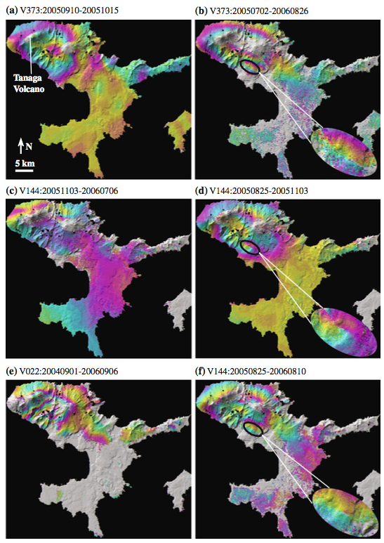 |
Selected deformation interferograms of Tanaga Island for the following time periods: a September 10, 2005?October 15, 2005 (Envisat track 373), b July 2, 2005?August 26, 2006 (Envisat track 373), c November 3, 2005?July 6, 2006 (Envisat track 144), d August 25, 2005? November 3, 2005 (Envisat track 144), e September 1, 2004? September 6, 2006 (Envisat track 022), and f August 25, 2005? August 10, 2006 (Envisat track 144). All but (c) span the October?November 2005 earthquake swarm, which escalated during October 1?7 and declined to near background level by late November. Deformation fringes are absent in (c), which spans an 8-month period following the peak of the swarm. Black ellipses in (b) (d), and (f) outline an area of anomalous fringes that might correspond to a landslide-like signal noted on seismic records for October 17, 2005. A full cycle of colors (i.e., one interferometric fringe) represents 2.83 cm of surface displacement along the satellite- to-ground LOS From: Lu and Dzurisin 2014. |
||
Reference List: Lu and Dzurisin 2014.
Full References:
Lu Z, Dzurisin D, 2014. InSAR imaging of Aleutian volcanoes: monitoring a volcanic arc from space. Springer-Verlag Berlin Heidelberg. https://doi.org/10.1007/978-3-642-00348-6
There is no Emissions History data available for Tanaga.
 Takawangha volcano (left), seen here from the E, has an ice-filled caldera on northern Tanaga Island. Numerous small cones are located within the caldera, as well as on the rim and flanks. Tanaga volcano is to the right.
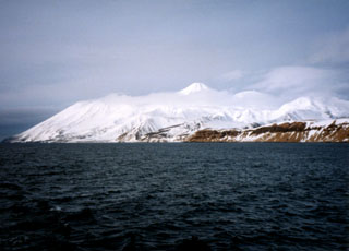 Tanaga is seen here from the SW with Cape Sajaka to the far left. The peak above the clouds is Tanaga, and Sajaka is to the left. Most Holocene eruptions originated from the central peak, which consists of two large cones constructed within a caldera with the 400-m-high rim to the SE.
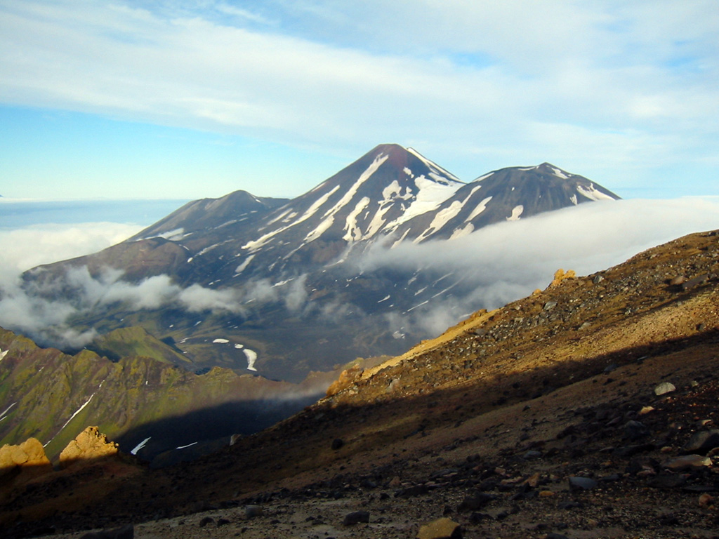
 The three E-W-trending summit cones of the Tanaga volcanic complex, Sajaka, Tanaga, and East Tanaga (from left to right) are seen from the summit of Takawangha volcano. Tanaga is the central and highest of three at the NW tip of Tanaga Island. The ridge to the lower left is part of a caldera rim that formed by the collapse of an ancestral Tanaga edifice during the Pleistocene.
The maps shown below have been scanned from the GVP map archives and include the volcano on this page. Clicking on the small images will load the full 300 dpi map. Very small-scale maps (such as world maps) are not included. The maps database originated over 30 years ago, but was only recently updated and connected to our main database. We welcome users to tell us if they see incorrect information or other problems with the maps; please use the Contact GVP link at the bottom of the page to send us email.
The following 54 samples associated with this volcano can be found in the Smithsonian's NMNH Department of Mineral Sciences collections, and may be availble for research (contact the Rock and Ore Collections Manager). Catalog number links will open a window with more information.
| Catalog Number | Sample Description | Lava Source | Collection Date |
|---|---|---|---|
| NMNH 118211-1 | Basalt | -- | 15 Sep 2015 |
| NMNH 118211-10 | Basaltic andesite scoria | -- | 15 Sep 2015 |
| NMNH 118211-11 | Basaltic andesite lapilli tephra | -- | 15 Sep 2015 |
| NMNH 118211-12 | Basaltic andesite scoria | -- | 15 Sep 2015 |
| NMNH 118211-13 | Volcanic Ash | -- | 16 Sep 2015 |
| NMNH 118211-14 | Fine ash | -- | 16 Sep 2015 |
| NMNH 118211-15 | Lapilli tephra | -- | 16 Sep 2015 |
| NMNH 118211-16 | Basaltic andesite lapilli tephra | -- | 16 Sep 2015 |
| NMNH 118211-17 | Basalt Scoria | -- | 16 Sep 2015 |
| NMNH 118211-18 | Scoria | -- | 16 Sep 2015 |
| NMNH 118211-19 | Volcanic Ash | -- | 16 Sep 2015 |
| NMNH 118211-2 | Scoriaceous tephra | -- | 15 Sep 2015 |
| NMNH 118211-20 | Lapilli tephra | -- | 16 Sep 2015 |
| NMNH 118211-21 | Basalt lapilli tephra | -- | 16 Sep 2015 |
| NMNH 118211-22 | Tephra | -- | 16 Sep 2015 |
| NMNH 118211-23 | Basalt lapilli tephra | -- | 18 Sep 2015 |
| NMNH 118211-24 | Lapilli tephra | -- | 18 Sep 2015 |
| NMNH 118211-25 | Lapilli tephra | -- | 18 Sep 2015 |
| NMNH 118211-26 | Lapilli tephra | -- | 18 Sep 2015 |
| NMNH 118211-27 | Lapilli tephra | -- | 18 Sep 2015 |
| NMNH 118211-28 | Coarse ash | -- | 18 Sep 2015 |
| NMNH 118211-29 | Basaltic andesite lapilli tephra | -- | 18 Sep 2015 |
| NMNH 118211-3 | Lapilli tephra | -- | 15 Sep 2015 |
| NMNH 118211-30 | Scoriaceous tephra | -- | 18 Sep 2015 |
| NMNH 118211-31 | Basalt scoriaceous tephra | -- | 16 Sep 2015 |
| NMNH 118211-32 | Basaltic andesite pumiceous tephra | -- | 16 Sep 2015 |
| NMNH 118211-33 | Pumiceous tephra | -- | 16 Sep 2015 |
| NMNH 118211-34 | Basalt scoriaceous tephra | -- | 16 Sep 2015 |
| NMNH 118211-35 | Pumiceous tephra | -- | 16 Sep 2015 |
| NMNH 118211-36 | Scoriaceous tephra | -- | 17 Sep 2015 |
| NMNH 118211-37 | Scoriaceous tephra | -- | 17 Sep 2015 |
| NMNH 118211-38 | Pumiceous lapilli tephra | -- | 17 Sep 2015 |
| NMNH 118211-39 | Basaltic andesite pumiceous tephra | -- | 17 Sep 2015 |
| NMNH 118211-4 | Basalt scoriaceous tephra | -- | 15 Sep 2015 |
| NMNH 118211-40 | Basaltic andesite pumiceous tephra | -- | 17 Sep 2015 |
| NMNH 118211-41 | Basaltic andesite pumiceous tephra | -- | 17 Sep 2015 |
| NMNH 118211-42 | Basalt scoriaceous tephra | -- | 17 Sep 2015 |
| NMNH 118211-43 | Lapilli tephra | -- | 17 Sep 2015 |
| NMNH 118211-44 | Lapilli tephra | -- | 17 Sep 2015 |
| NMNH 118211-45 | Lapilli tephra | -- | 17 Sep 2015 |
| NMNH 118211-46 | Scoriaceous tephra | -- | 18 Sep 2015 |
| NMNH 118211-47 | Basalt scoriaceous tephra | -- | 18 Sep 2015 |
| NMNH 118211-48 | Lapilli tephra | -- | 18 Sep 2015 |
| NMNH 118211-49 | Lapilli tephra | -- | 18 Sep 2015 |
| NMNH 118211-5 | Basalt lapilli tephra | -- | 15 Sep 2015 |
| NMNH 118211-50 | Coarse ash | -- | 18 Sep 2015 |
| NMNH 118211-51 | Scoriaceous tephra | -- | 19 Sep 2015 |
| NMNH 118211-52 | Lapilli tephra | -- | 19 Sep 2015 |
| NMNH 118211-53 | Coarse ash | -- | 19 Sep 2015 |
| NMNH 118211-54 | Scoriaceous tephra | -- | 19 Sep 2015 |
| NMNH 118211-6 | Scoria | -- | 15 Sep 2015 |
| NMNH 118211-7 | Basaltic andesite pumiceous tephra | -- | 15 Sep 2015 |
| NMNH 118211-8 | Basaltic Andesite | -- | 15 Sep 2015 |
| NMNH 118211-9 | Basalt Scoria | -- | 15 Sep 2015 |
| Alaska Volcano Observatory (Link to Tanaga) | The Alaska Volcano Observatory (AVO) is a joint program of the U.S. Geological Survey (USGS), the Geophysical Institute of the University of Alaska Fairbanks (UAFGI), and the State of Alaska Division of Geological and Geophysical Surveys (ADGGS). AVO was formed in 1988, and uses federal, state, and university resources to monitor and study Alaska's hazardous volcanoes, to predict and record eruptive activity, and to mitigate volcanic hazards to life and property. |
| Copernicus Browser | The Copernicus Browser replaced the Sentinel Hub Playground browser in 2023, to provide access to Earth observation archives from the Copernicus Data Space Ecosystem, the main distribution platform for data from the EU Copernicus missions. |
| MIROVA | Middle InfraRed Observation of Volcanic Activity (MIROVA) is a near real time volcanic hot-spot detection system based on the analysis of MODIS (Moderate Resolution Imaging Spectroradiometer) data. In particular, MIROVA uses the Middle InfraRed Radiation (MIR), measured over target volcanoes, in order to detect, locate and measure the heat radiation sourced from volcanic activity. |
| MODVOLC Thermal Alerts | Using infrared satellite Moderate Resolution Imaging Spectroradiometer (MODIS) data, scientists at the Hawai'i Institute of Geophysics and Planetology, University of Hawai'i, developed an automated system called MODVOLC to map thermal hot-spots in near real time. For each MODIS image, the algorithm automatically scans each 1 km pixel within it to check for high-temperature hot-spots. When one is found the date, time, location, and intensity are recorded. MODIS looks at every square km of the Earth every 48 hours, once during the day and once during the night, and the presence of two MODIS sensors in space allows at least four hot-spot observations every two days. Each day updated global maps are compiled to display the locations of all hot spots detected in the previous 24 hours. There is a drop-down list with volcano names which allow users to 'zoom-in' and examine the distribution of hot-spots at a variety of spatial scales. |
|
WOVOdat
Single Volcano View Temporal Evolution of Unrest Side by Side Volcanoes |
WOVOdat is a database of volcanic unrest; instrumentally and visually recorded changes in seismicity, ground deformation, gas emission, and other parameters from their normal baselines. It is sponsored by the World Organization of Volcano Observatories (WOVO) and presently hosted at the Earth Observatory of Singapore.
GVMID Data on Volcano Monitoring Infrastructure The Global Volcano Monitoring Infrastructure Database GVMID, is aimed at documenting and improving capabilities of volcano monitoring from the ground and space. GVMID should provide a snapshot and baseline view of the techniques and instrumentation that are in place at various volcanoes, which can be use by volcano observatories as reference to setup new monitoring system or improving networks at a specific volcano. These data will allow identification of what monitoring gaps exist, which can be then targeted by remote sensing infrastructure and future instrument deployments. |
| Volcanic Hazard Maps | The IAVCEI Commission on Volcanic Hazards and Risk has a Volcanic Hazard Maps database designed to serve as a resource for hazard mappers (or other interested parties) to explore how common issues in hazard map development have been addressed at different volcanoes, in different countries, for different hazards, and for different intended audiences. In addition to the comprehensive, searchable Volcanic Hazard Maps Database, this website contains information about diversity of volcanic hazard maps, illustrated using examples from the database. This site is for educational purposes related to volcanic hazard maps. Hazard maps found on this website should not be used for emergency purposes. For the most recent, official hazard map for a particular volcano, please seek out the proper institutional authorities on the matter. |
| IRIS seismic stations/networks | Incorporated Research Institutions for Seismology (IRIS) Data Services map showing the location of seismic stations from all available networks (permanent or temporary) within a radius of 0.18° (about 20 km at mid-latitudes) from the given location of Tanaga. Users can customize a variety of filters and options in the left panel. Note that if there are no stations are known the map will default to show the entire world with a "No data matched request" error notice. |
| UNAVCO GPS/GNSS stations | Geodetic Data Services map from UNAVCO showing the location of GPS/GNSS stations from all available networks (permanent or temporary) within a radius of 20 km from the given location of Tanaga. Users can customize the data search based on station or network names, location, and time window. Requires Adobe Flash Player. |
| DECADE Data | The DECADE portal, still in the developmental stage, serves as an example of the proposed interoperability between The Smithsonian Institution's Global Volcanism Program, the Mapping Gas Emissions (MaGa) Database, and the EarthChem Geochemical Portal. The Deep Earth Carbon Degassing (DECADE) initiative seeks to use new and established technologies to determine accurate global fluxes of volcanic CO2 to the atmosphere, but installing CO2 monitoring networks on 20 of the world's 150 most actively degassing volcanoes. The group uses related laboratory-based studies (direct gas sampling and analysis, melt inclusions) to provide new data for direct degassing of deep earth carbon to the atmosphere. |
| Large Eruptions of Tanaga | Information about large Quaternary eruptions (VEI >= 4) is cataloged in the Large Magnitude Explosive Volcanic Eruptions (LaMEVE) database of the Volcano Global Risk Identification and Analysis Project (VOGRIPA). |
| EarthChem | EarthChem develops and maintains databases, software, and services that support the preservation, discovery, access and analysis of geochemical data, and facilitate their integration with the broad array of other available earth science parameters. EarthChem is operated by a joint team of disciplinary scientists, data scientists, data managers and information technology developers who are part of the NSF-funded data facility Integrated Earth Data Applications (IEDA). IEDA is a collaborative effort of EarthChem and the Marine Geoscience Data System (MGDS). |