HVO reported that Kamaehuakanaloa volcano (formerly Loihi Seamount), located offshore SE of the Island of Hawaii, began a period of heightened seismic unrest at around 1800 on 1 November. A swarm of more than 70 earthquakes occurred, with 32 events being greater than M 2.0 and two events greater than M 4.0. The largest earthquake, a M 4.3 event, occurred at 1205 on 2 November at a depth of 5.8 km (3.6 miles) below sea level and 4.8 km (3.0 miles) below the summit. There was only one report of someone feeling the earthquake. Seismic activity slightly declined later that day around midnight, though it remains above background levels as of 2 November. The Alert Level remained at Unassigned and the Aviation Color Code remained Unassigned as well.
Source: US Geological Survey Hawaiian Volcano Observatory (HVO)
Seismic swarms during 2001-2006
K. H. Rubin of the University of Hawaii provided some of the following information concerning Lōʻihi volcano, noting that there hasn't been much activity reported over the last 10 years. The ocean bottom seismometer (OBS) died several months after installation in mid-1996 because the cable connecting it to land was not armored and thus failed early after deployment. However, using available seismic data from the OBS and the Hawaiian Volcano Observatory (HVO) land network, Caplan-Auerbach and others (2001), were able to develop a more precise crustal velocity model so that seismic events at Lōʻihi recorded by the land stations at Kīlauea can now be precisely located. Unfortunately, only large events (probably >M 3 or M 4) are detected.
Several papers were published on Lōʻihi by Schipper and others (2010, 2011) looking at a reworked pyroclastic section of unknown age on the summit platform and making inferences on eruptive conditions (especially on the conditions of vesiculation and fragmentation). The samples for their studies were collected during the last known geological dives to the summit by Hawaii Undersea Research Laboratory (HURL) and NOAA in 2007.
Seismic swarms during 2001-2006. The Lōʻihi website reported that a seismic swarm was detected at Lōʻihi's summit with earthquakes up to M 5.2 on 13 September 2001. Activity continued for a couple of weeks, with 4 events >M 4 at depths of 12-13 km. No >M 4 earthquakes were detected at Lōʻihi during 2002-2004. An M 4.3 earthquake occurred on 23 April 2005 at ~33 km depth beneath Lōʻihi, and earthquakes of M 5.1 and 5.4 occurred on 13 May and 17 July 2005, respectively, both at a depth of 44 km. The U.S. Geological Survey Advanced National Seismic System measured a small swarm of about 100 earthquakes (the largest 3 events were ~M 4, and between 12 and 28 km deep) that occurred beneath Lōʻihi on 7 December 2005. A more recent earthquake (estimated M 4.7) occurred on 18 January 2006, roughly midway between Lōʻihi and Pahala (on the S coast of the island of Hawaii).
References. Caplan-Auerbach, J., and Duennebier, F.K., 2001, Seismicity and Velocity Structure of Lōʻihi Seamount from the 1996 Earthquake Swarm, Bulletin of the Seismological Society of America, v. 91, no. 2, p. 178-190.
Rubin, K.H., Soule, S.A., Chadwick Jr., W.W., Fornari, D.J., Clague, D.A., Embley, R.W., Baker, E.T., Perfit, M.R., Caress, D.W., and Dziak, R.P., 2012, Volcanic eruptions in the deep sea, Oceanography, v. 25, no. 1, p. 142-157.
Schipper, C.I., White, J.D.L., and Houghton, B.F., 2010, Syn- and post-fragmentation textures in submarine pyroclasts from Lo`ihi Seamount, Hawai`i, Journal of Volcanology and Geothermal Research, v. 191, issues 3-4, p. 93-106.
Schipper, C.I., White, J.D.L., and Houghton, B.F., 2011, Textural, geochemical, and volatile evidence for a Strombolian-like eruption sequence at Lo`ihi Seamount, Hawai`i, Journal of Volcanology and Geothermal Research, v. 207, issues 1-2, p. 16-32.
Information Contacts: Lo`ihi Volcano website (URL: http://www.soest.hawaii.edu/GG/HCV/loihi.html); K. H. Rubin, Department of Geology and Geophysics, School of Ocean and Earth Science and Technology (SOEST), University of Hawaii at Manoa, Honolulu, HI (URL: http://www/soest.hawaii.edu/GG); U.S. Geological Survey Earthquake Information Center (NEIC) (URL: https://earthquake.usgs.gov/neis); Hawaiian Volcano Observatory (HVO), U.S. Geological Survey, PO Box 51, Hawaii National Park, HI 96718, USA (URL: https://volcanoes.usgs.gov/observatories/hvo/).
2024: October
2022: July
2001: September
HVO reported that Kamaehuakanaloa volcano (formerly Loihi Seamount), located offshore SE of the Island of Hawaii, began a period of heightened seismic unrest at around 1800 on 1 November. A swarm of more than 70 earthquakes occurred, with 32 events being greater than M 2.0 and two events greater than M 4.0. The largest earthquake, a M 4.3 event, occurred at 1205 on 2 November at a depth of 5.8 km (3.6 miles) below sea level and 4.8 km (3.0 miles) below the summit. There was only one report of someone feeling the earthquake. Seismic activity slightly declined later that day around midnight, though it remains above background levels as of 2 November. The Alert Level remained at Unassigned and the Aviation Color Code remained Unassigned as well.
Source: US Geological Survey Hawaiian Volcano Observatory (HVO)
An earthquake swarm began at Kama'ehuakanaloa at about 0200 on 16 July and was characterized by seismic tremor accompanied by pulses of seismic energy every 15-20 seconds. The pattern of elevated seismicity continued through at least 1453 on 17 July, the posting time of the HVO’s information statement. The report also noted that around 24 earthquakes in the M 1.8-3 range were recorded during 0130-0600 on 17 July. The Scientist-in-Charge stated that the seismicity was likely the result of magma movement beneath the seamount, but there were no show signs of an imminent eruption. The most recent swarm was recorded on 11 May 2020 and consisted of 18 events in the M 3-3.9 range. The Volcano Alert Level and the Aviation Color Code both remained at Unassigned; there are no working monitoring instruments on the volcano so information is based on and-based seismometers.
Source: US Geological Survey Hawaiian Volcano Observatory (HVO)
An earthquake swarm occurred at Loihi during 10-11 September and two 13 September earthquakes may have also been part of the swarm. The two later earthquakes occurred at 0311 and 0839 and had magnitudes of 4.9 and 4.4, respectively. Most of the earthquakes from 10-13 September were ~12 km deep and located slightly S of the summit of the volcano.
Source: US Geological Survey Hawaiian Volcano Observatory (HVO)
On 10 September an earthquake swarm began at Loihi. The swarm began with a M 5 earthquake and was followed by M 3.5-4.5 earthquakes until at least 11 September. This was the most severe swarm at Loihi since July 1996, when the summit collapsed.
Source: US Geological Survey Hawaiian Volcano Observatory (HVO)
Reports are organized chronologically and indexed below by Month/Year (Publication Volume:Number), and include a one-line summary. Click on the index link or scroll down to read the reports.
Increased seismicity; nine events of magnitude 3 or greater
"Since November 1984, a renewed increase in earthquakes in the Lōʻihi region has been recorded on the HVO seismic network. The recent activity occurred episodically in three minor bursts on 11 November and 10 and 21 January. From November 1984 to January 1985, 19 earthquakes of magnitude 2.0 or greater occurred in the Lōʻihi region (figure 1). Nine of the larger events ranged in magnitude from 3.0 to 4.2.
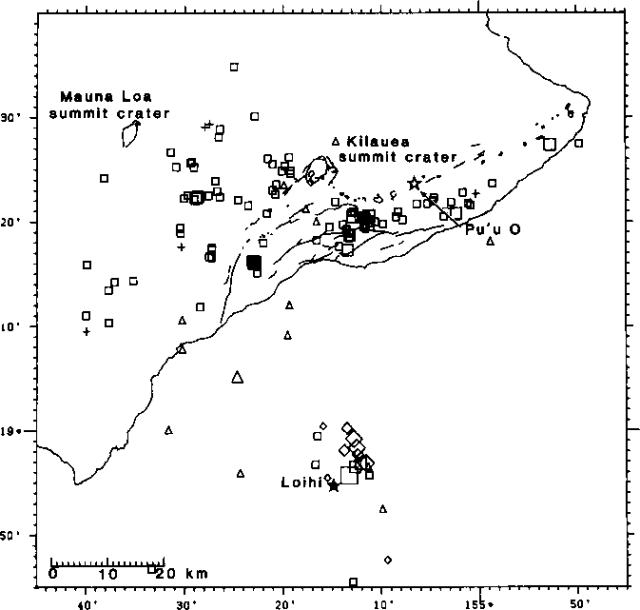 |
Figure 1. Plot of earthquakes of M >= 2 in the Hawaii region, November 1984-January 1985. Squares indicate events with depths of 5-13 km, diamonds 13-20 km, and triangles > 20 km. Symbols of different sizes show the relative magnitudes of events; the largest event near Lōʻihi was M 4.2. |
"Although the current activity is relatively minor, swarm earthquakes characteristically associated with magmatic movement and volcanism in Hawaii have been known to gradually develop from such episodic increases. Significant earthquake swarms inferring magmatic activity at Lōʻihi were detected in 1971-72 and 1975. The recurring episodes of earthquake swarms suggesting development of volcanism S of Hawaii are consistent with the pattern of progressive southeastward growth of the Hawaiian Islands in the context of plate tectonics and volcanism in the mid-Pacific region."
The nearest seismic station is about 30 km from Lōʻihi on the S coast of the island of Hawaii. Seismic events at Lōʻihi smaller than magnitude 2 may be recorded by stations on Hawaii, but their locations cannot be determined as precisely as for larger events.
Information Contacts: R. Koyanagi and W. Tanigawa, USGS Hawaiian Volcano Observatory.
Earthquake swarm
On 20 September, an earthquake swarm occurred in the vicinity of Lōʻihi. Seven events of M 2.8-3.9 were recorded between 1900 and 2300 before seismicity declined (figure 2).
 |
Figure 2. Hypocenters of earthquakes in the vicinity of Hawaii and Lōʻihi seamount, September 1986. Courtesy of USGS. |
Information Contacts: C. Heliker, USGS Hawaiian Volcano Observatory.
Earthquake swarm may document magma intrusion
An earthquake swarm, detected 24 January 1989 from 0736 to 1009, included 12 relatively large events (M 2.5-3.6) and 15 smaller events (M 1.3-2.5) superimposed on continuous background tremor (figure 3). Ten events (M 1.5-2.3) of relatively high frequencies followed during the remainder of the day, then declined. After four events [of M 1.3-2.5] on the 25th, only sporadic seismicity [consisting of four more events during 26-31 January of M 1.2-2.9] was recorded. Frequencies were characteristic of tectonic-type events, suggesting to USGS geophysicists that they may have marked an intrusive episode, but probably not an eruption. Depth control was limited, since the nearest seismic station is on the S coast of Hawaii, >30 km away.
 |
Figure 3. Preliminary locations of January 1989 earthquakes (M > 2.0) at Lōʻihi and on the island of Hawaii. Courtesy of Robert Koyanagi, USGS Hawaiian Volcano Observatory. |
Information Contacts: R. Koyanagi, USGS Hawaiian Volcano Observatory.
Strong earthquake swarm, suggesting magma movement
A vigorous earthquake swarm occurred off the S flank of Hawaii 11-19 March 1990 (figure 4). More than 300 events were registered, about 15 of M 3-4, and some of M >4. Seismologists associated many of the events, including the larger ones, with processes at Lōʻihi Seamount. No acoustic signals (T-waves) were reported.
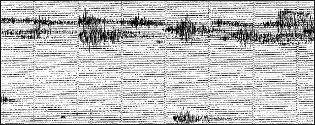 |
Figure 4. Portion of a seismogram recorded during Lōʻihi's 11 March 1990 earthquake swarm, by a station (AHU) 45 km from the epicentral area. Courtesy of R. Koyanagi. |
Further Reference. Malahoff, A., 1987, Geology of the summit of Lōʻihi submarine volcano, in Decker, R.W., Wright, T.L., and Stauffer, P.H., eds., Volcanism in Hawaii: USGS Professional Paper 1350, p. 133-144.
Information Contacts: P. Okubo and R. Koyanagi, USGS Hawaiian Volcano Observatory.
Earthquake swarm
An earthquake swarm centered near Lōʻihi Seamount began with a sudden burst of events between 0200 and 0300 on 19 December 1991, with the most vigorous activity continuing through 1900 the next day. By late afternoon on 23 Dec, seismic stations on Hawaii were no longer detecting any activity in the Lōʻihi area. Of the more than 400 recorded events, 16 exceeded M 3.0. Hypocenters were recomputed with the HYPOINVERSE program (figure 5). The swarm events were located beneath the steep E flank and appeared to be concentrated at 10-20 km depth, although recording geometry does not allow tight constraint of focal depths. Work is continuing to re-evaluate the velocity model and hypocentral estimates. No seismic instruments or hydrophones were functioning on or near the Lōʻihi edifice during the swarm.
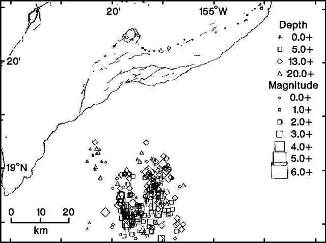 |
Figure 5. Hypocenters of swarm events near Lōʻihi Seamount, 19-23 December 1991. Locations are from the HYPOINVERSE program. Courtesy of HVO. |
A plot of 1986-90 events (figure 6) outlines Lōʻihi's summit. The summit region was surveyed in 1986; an August/September 1991 SeaBeam resurvey from the NOAA ship Discoverer revealed no significant morphologic changes exceeding the 5-15 m resolution of the comparison technique.
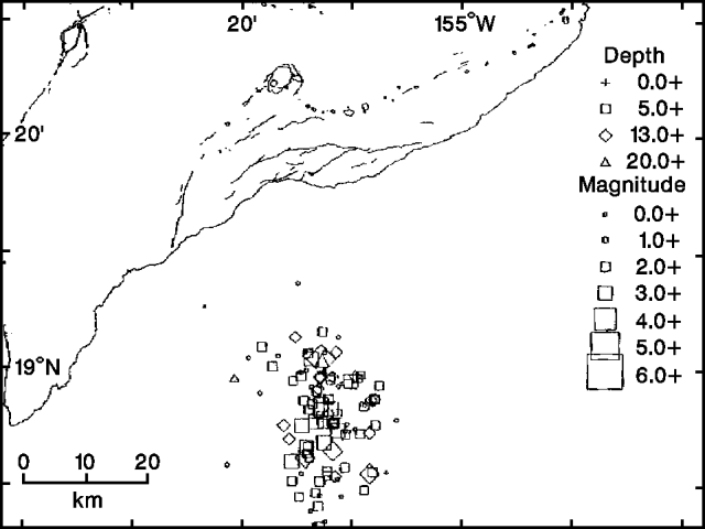 |
Figure 6. Hypocenters of swarm events near Lōʻihi Seamount, 1986-90, located using the HYPOINVERSE program. Courtesy of HVO. |
Information Contacts: P. Okubo, USGS Hawaiian Volcano Observatory; W. Chadwick, Oregon State University; C. Fox, NOAA.
Five hours of seismicity on 11 July
A flurry of seismicity occurred from Lōʻihi for ~5 hours on the evening of 11 July 1993; only of few events were locatable, the largest was M 2.9. [Originally in Kīlauea report.]
Information Contacts: P. Okubo, HVO.
Seismic swarm on S flank
A microearthquake swarm occurred on the morning of 12 October 1993 with >140 events counted in two days. The peak of this activity occurred in the first 4 hours with 90 events counted from 1000-1400 on 12 October. Eight of these events had M >3. Hypocentral determinations indicated that the S flank of the seamount was active at that time.
Information Contacts: T. Mattox and P. Okubo, USGS Hawaiian Volcano Observatory.
Earthquake swarm
An earthquake swarm late on 27 April consisted of 75 events. Only 42 of these were large enough to process for locations. Seismic events from Lōʻihi continued through the end of April, with the largest a M 2.9. Seismic swarms are fairly common at Lōʻihi, and were last reported on 11 July and 12 October 1993 (BGVN 18:07 and 18:10), and 19 December 1991 (BGVN 16:12). This youngest volcano of the Hawaiian chain lies ~35 km SE of Hawaii. The summit region is dotted with numerous lava cones, and the abundant fresh, sediment-free lavas attest to its youthful age. Seismicity indicates that the plumbing system is distinct from that of Kīlauea, 55 km N.
Information Contacts: Paul Okubo, USGS Hawaiian Volcano Observatory (HVO), Hawaii Volcanoes National Park, HI 96718, USA.
Earthquake swarm and a new submarine pit crater
The largest swarm of earthquakes ever recorded on the Hawaiian volcanoes occurred below Lōʻihi seamount in July-August (figures 7 and 8). The seismic network maintained by the Hawaiian Volcano Observatory (HVO) began detecting events from this swarm at 2154 on 16 July; events continued at low rates until 20 July, when counts rapidly increased. More than 4,000 earthquakes were recorded through 29 July. Several hundred of M >= 3.0 were detected, and more than 80 were M >= 4. The largest event, M 5.0, occurred at 2330 on 27 July. The number of events decreased in early August.
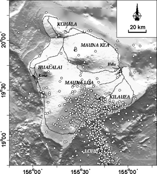 |
Figure 7. Distribution of Hawaiian earthquakes during 12- 25 July. Courtesy of HVO. |
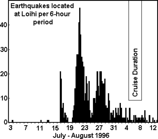 |
Figure 8. Histogram of the Lōʻihi earthquakes, 3 July-13 August 1996. Each vertical bar represents a 6-hour time period. Courtesy of the Hawaii Center for Volcanology. |
In an effort sponsored by the U.S. National Science Foundation, an interdisciplinary team of researchers from the University of Hawaii, in collaboration with scientists from the U.S. Geological Survey, the Bishop Museum, and the University of Washington, investigated this unique event. The team left Honolulu at 0700 on 5 August and returned on the evening of 10 August after a six-day observation by the research ship and manned submersible. The following summary is from the daily reports of the Hawaii Center for Volcanology.
6 August. Amidst ongoing intense seismic and inferred volcanic activity, scientists were rocked by several earthquakes felt through the hull of the research vessel Kaimikai O Kanaloa (RV KOK) as they steamed over Lōʻihi. On their first pass over the volcano, they noted that Pele's Vents, an area 980 m below the surface where active hydrothermal venting had been recorded by previous cruises, was no longer there. The area was now the site of a pit crater 260 m in diameter and 300 m deep (named "Pele's Puka"), roughly the same size as similar craters at Kīlauea. Water samples recovered from the area near Pele's Puka were 2.5°C warmer than the surrounding water and highly acidic, indicating that they were nearly saturated in carbon dioxide. The water samples were milky brown in color because of suspended fine particles of what is probably volcanic glass. These characteristics, along with other chemical indicators, imply that the samples were taken very close to an underwater volcanic eruption.
7 August. Scientists raised and lowered instruments in the water, mainly looking for anomalies in water temperature and chemistry and also listening for sounds that might indicate an eruption. Except for the area around the peak of Lōʻihi, the sounds and water appeared normal, but toward the S end of the summit region the water was considerably warmer than usual, charged with carbon dioxide, and loaded with suspended particles. This "plume" of warm water was among the most intense ever recorded in the ocean. Sonobuoys, which broadcast sounds back to the ship by radio from underwater microphones, picked up crackling and grinding noises in the summit area, which could have been sounds of an eruption in progress.
8 August. Scientists in the PISCES V manned submersible landed near the highest point of the seamount (PISCES Peak) and worked their way slowly toward the new pit crater through murky waters, with visibility
Information Contacts: Hawaii Center for Volcanology, Department of Geology & Geophysics, University of Hawaii at Manoa, 2525 Correa Road, Honolulu, HI 96822 USA (URL: http://www.soest.hawaii.edu/GG/hcv.html); Hawaiian Volcano Observatory (HVO), U.S. Geological Survey, PO Box 51, Hawaii National Park, HI 96718, USA (URL: http://www.soest.hawaii.edu/hvo/).
Active hydrothermal venting, turbid water, and debris slides
The onset of an intense earthquake swarm, which began in mid-July, prompted a rapid-response cruise and submersible dives during early August (BGVN 21:07). Scientists from the University of Hawaii once again used the research vessel Ka'imikai O Kanaloa (R/V KOK) and PISCES V manned submersible to carry out two follow-up research cruises over Lōʻihi during 26-28 September and 2-10 October, respectively. The following summarized observations are from reports of the Hawaii Center for Volcanology.
Observations on 26-28 September. During 26 September the divers found hydrothermal venting on the bottom of the newly formed Pele's Pit (figure 9). In the summit area N of East Pit, no volcanic activity was observed, but a number of broken-up pillows were discovered. There was no activity at West Pit, however, the divers saw columnar basalt that appeared to be teetering due to collisions from debris slides. Some noise was heard with sonobuoys the next day. In East Pit on 27 September, divers saw a mudslide but no venting. Visibility was poor due to particles coming from Pele's Pit via a channel between the two pits. In Pele's Pit, active venting was observed on the upper W wall below Pele's Lookout. The divers encountered vents early during the dive on 28 September. The dive was aborted after the submersible brushed an unseen wall and damaged a thruster.
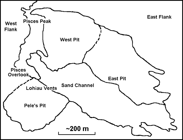 |
Figure 9. Sketch map of the Lōʻihi Seamount. View is from the SSE. After Carlowicz (1996); original image by J.R. Smith, Jr., University of Hawaii. |
Observations on 2-3 October. The dive on 2 October began in the "sand channel" between the pre-existing East Pit and the new Pele's Pit. The bottom of the channel was covered with a thick layer of fine-grained sediments. A miniature temperature recorder (MTR) was deployed, and a maximum vent-fluid temperature of >18°C was measured. At the W end of the vent field at Pele's Pit (1,175-m depth), numerous vents were seen; most were covered with white, streaming mats. This area, dubbed the rubble zone, extended perhaps 50-60 m in diameter, and was marked with several locations of recent slides and a few relatively stable benches. At night a tow-yo survey of nearly 18-km length was run up the W side of the main N-S axis of the seamount. A nephelometer detected a large number of plumes over the N half of the survey concentrated at ~1,350 and 1,050 m depth beside a large summit plume at a depth of ~1,150 m.
Vents were found the next day with a maximum vent-fluid temperature of 77°C, a much higher temperature than any previously measured at Lōʻihi. A hydrocast into Pele's Pit showed that water-temperature anomalies had greatly decreased after the rapid-response cruise in August (a few tenths of a degree vs. three degrees). However, a distinct turbidity maximum remained in the bottom waters.
Observations on 4-6 October. A submersible dive up the S rift was conducted to investigate the origin of a hydrothermal plume at 1,350-m depth detected on 2 October. A new hydrothermal vent field was found on the rift axis at 1,325-m depth, and was named "Naha Vents". This extensive vent field contained many fresh fractures, including a fissure (1-3 m wide) that vented large volumes of water. A smaller vent had a measured temperature of 11.2°C. The dive concluded farther up the rift at the site of the previously active Kapo's Vents (1,250-m depth); no hydrothermal activity was observed there. At night a ship-based water sampling program included a ~13 km long SW-NE tow-yo survey across the summit (the tow was run parallel to the predominantly NE current). A hydrothermal plume was first detected 6.5 km downcurrent from the summit.
Observations on 5 October showed that the Naha vent field was ~20 x 30 m, and was heavily covered with nontronite deposits and tan bacterial mats. The field contained many small vents, as well as diffuse flows through fractured pillows and large fissures. The highest vent-fluid temperature was 22.7°C. Night water sampling (vertical hydrocast) 1.4 km downcurrent (NE) from the summit revealed six major turbidity maxima at depths of 1,050-1,330 m. The strongest signal, at 1,080 m, was associated with a significant temperature anomaly. This suggested that there might be an undiscovered major source of venting at the summit (all of the vents discovered thus far are below 1,180 m).
Water sampling the night of 6 October better located the sources of the large shallow (1,000-1,105 m depth) turbidity and temperature-anomaly maxima observed on 5 October. Hydrocasts and tow-yos across the seamount suggested that a major venting site should be just S of Pele's Pit near the top of the S rift.
Observations on 7-10 October. An MTR showed a slow increase in temperature from 48 to 53°C over its deployment during 4-7 October, with some daily variations. The dive on 7 October explored a site covered with nontronite-coated gravels where diffuse venting was observed at a depth of 1,099 m. This field was likely an early stage of the "finger vent"-type hydrothermal fields seen previously on Lōʻihi, and was named "Ula Vents". The dive concluded on the steep W flank of the summit at a site of previously observed intermittent venting (Maximilian Vents) at 1,249-m depth. A night water sampling program ran two perpendicular 5-km-long tow-yo sections near the summit. In the both runs, plume maxima were in the vicinity of Kapo's Vents. A hydrocast at West Pit indicated a substantial particle plume above the pit with no associated temperature anomaly.
The 8 October dive began just W of the site of Kapo's Vents, a small field that was active in the late 1980s. As on the section of the S rift already explored, large volumes of clay- to gravel-sized sediments covered much of the area. Pele's hair and flat sheets of glass that formed as walls of large lava bubbles were common. One interesting feature was ~5-cm-diameter holes at several sites in the sand layer that appeared to be locations of recently terminated venting. An area of modest venting through a mound of small nontronite-covered boulders was found at a depth of 1,196 m. A maximum vent-fluid temperature of 17.2°C was measured. At night a S-to-N tow 3 km W of the seamount axis showed that the bulk of the hydrothermal plume above Lōʻihi had shifted from the WSW to the NE over the previous few days.
Dive operations the next day focused on completing work at Lohiau Vents. The dive finished at the E end of the vent field and collected rocks bearing several high-temperature sulfide minerals; these suggested that vent-fluid temperatures during the July-August seismic event might have been much higher. The hydrothermal site sampled on 8 October at a depth of 1,196 m on the S rift was confirmed to be a new field. It was named "Pohaku Vents".
On 10 October, a repeat of the tow-yo section made on 8 October revealed that the plume had shifted to nearly due N. This shift during only a few days indicated the speed at which the ocean currents carrying the Lōʻihi plumes could change their orientation. During the whole cruise, 71 km of tow-yos were conducted, making Lōʻihi one of the most intensively studied submarine hydrothermal systems.
Reference. Carlowicz, M., 1996, Earthquake swarm heats up Lōʻihi: EOS, v. 77, no. 42, p. 405-406.
Information Contacts: Hawaii Center for Volcanology, Department of Geology & Geophysics, University of Hawaii at Manoa, 2525 Correa Road, Honolulu, HI 96822 USA (URL: http://www.soest.hawaii.edu/GG/hcv.html); Hawaiian Volcano Observatory (HVO), U.S. Geological Survey, PO Box 51, Hawaii National Park, HI 96718, USA (URL: http://www.soest.hawaii.edu/hvo/).
200°C fluids; radiometric ages for lavas erupted just prior to the 1996 seismic swarm
The following report summarizes a series of Lōʻihi updates provided by the Hawaii Center for Volcanology. The largest swarm of earthquakes ever recorded at the Hawaiian volcanoes occurred below Lōʻihi Seamount during July-August 1996. Pele's Pit, a new pit crater, was detected during scientific dives after the seismic events. Pele's Pit formed at the site of Pele's Vents, a preexisting hydrothermal vent field. The events of July-August 1996 are detailed in BGVN 21:07 and 21:09.
Report of 1-30 November 1996. Radiometric dating was undertaken using the 210Po-210Pb technique, a process with a 138.4-day half-life, on two fresh lavas collected after the August 1996 seismic event; early results showed that the lavas were of different ages, but both predate the swarm event by 1-10 weeks. A later report of final results indicated that the lavas were erupted in February-March and May-June 1996. A separate set of geochemical analyses were conducted on rocks and sediments from a young breccia deposit on the W flank of Lōʻihi's summit; preliminary geochemical and petrological analysis suggests that magma was stored at a depth of ~10 km before being mixed with a more mafic magma. This mixing of two magmas may have triggered the eruption.
Observations of the seamount included a thin coating of hydrothermal sulfides detected at vent site 5 in Pele's Pit and abundant sedimentary deposits of black sand in the summit region and along some sections of Lōʻihi's S rift. The presence of bubble glass fragments indicated that some past eruptions were more violent than previously thought. Formation of ground cracks and fissures on the S rift at 1,300-1,400 m depth occurred at the time of the collapse of the summit pit. The fissures crosscut a previously unknown low-temperature hydrothermal vent field. The lack of temperature anomalies deeper than the new vent field and the small volume of the pit (~0.05-0.15 km3) suggest that the summit collapse was caused by magma intrusion into the upper part of the S rift, but that no eruption ensued.
Reports of early-mid and August-October 1997. The seamount was relatively quiet from late 1996 through mid-1997. No new major seismic activity occurred since August 1996.
During August and September 1997, manned submersible exploration revealed high-temperature hydrothermal fluids issuing from vents in Pele's Pit and water temperatures up to 200°C. High-temperature hydrothermal mineral deposits similar to those documented on mid-ocean ridge volcanoes were also observed; these did not resemble lower temperature materials previously found at Lōʻihi. Widespread deposits of young-looking volcanic sand were reported on the summit.
During the initial deployment of the Hawaii Undersea Geo Observatory (HUGO) in the second week of October, noises that could be interpreted as eruption-related were recorded by a hydrophone. The noises were intense and thunder-like but were not accompanied by elevated seismic activity.
Information Contacts: K. H. Rubin; Lester Sacks, Khal Spencer, Kevin Johnson, Mike Garcia, Marc Norman, and J.M. Rhodes, Hawaii Center for Volcanology, Department of Geology & Geophysics, University of Hawaii at Manoa, 2525 Correa Road, Honolulu, HI 96822 USA (URL: http://www.soest.hawaii.edu/GG/hcv.html); David Clague, Monterey Bay Aquarium Research Institute, P.O. Box 628, Moss Landing, CA 95039 USA.
Repaired observatory reveals February eruption
The Hawaii Undersea Geo-Observatory (HUGO) was visited on 19 January by the Pisces V submersible for the first time since its installation in mid-October 1997 (BGVN 22:09). The observatory, which consists of a hydrophone, and temperature and pressure sensors at a depth of 1.2 km, ceased operating in late October due to electrical problems; it was repaired and immediately began recording. At this time, whale sounds, but no volcanic activity, were heard at the seamount.
In early February, HUGO monitors indicated an eruption was underway. Transient acoustic signals with varying frequencies from several hertz to several kilohertz were recorded on the hydrophone. The signals varied in duration from seconds to minutes. A signal consisting of a low frequency "roar" followed by a high frequency "hiss" that lasted for several minutes occurred several times per day. The exact location of the eruption has not been determined; based on signal arrival times at the HUGO instruments and at the ocean surface, the eruption was estimated to be occurring within 2 km of the HUGO array at Lōʻihi.
[Later sonobuoy data showed that the eruption signals recorded by HUGO were caused by explosive activity at Kīlauea lava-flow ocean entries; there was no eruptive activity at Lōʻihi during the 27 January-26 April 1998 time period (Caplan-Auerbach and Duennebier, 2001).]
An article by The 1996 Lōʻihi Science Team (1997) discusses mid-1996 observations and includes a contoured bathymetric map of the summit area.
Reference. The 1996 Lōʻihi Science Team, 1997, Researchers rapidly respond to submarine activity at Lōʻihi volcano: Hawaii, Eos, Transactions, American Geophysical Union, v. 78, no. 22 (3 June 1997), p. 229.
Caplan-Auerbach, J., and Duennebier, F., 2001, Seismic and acoustic signals detected at Lōʻihi seamount by the Hawaii Undersea Geo-Observatory: Geochem. Geophys. Geosyst., 2, paper 2000GC000113, May 25 2001.
Information Contacts: K. H. Rubin and Mike Garcia, Hawaii Center for Volcanology, Department of Geology & Geophysics, University of Hawaii at Manoa, 2525 Correa Road, Honolulu, HI 96822 USA (URL: http://www.soest.hawaii.edu/GG/hcv.html).
Earthquake swarm during 10-13 September 2001
On the afternoon of 10 September 2001 an earthquake swarm began at Lōʻihi. The swarm began with a M 5 earthquake and was followed by M 3.5-4.9 earthquakes until the morning of 11 September. This was the most severe swarm at Lōʻihi since July 1996, when the summit collapsed. Two earthquakes that occurred on 13 September may have also been part of the swarm. The two later earthquakes occurred at 0311 and 0839 and had magnitudes of 4.9 and 4.4, respectively. Most of the earthquakes from 10-13 September were ~12 km deep and located slightly S of Lōʻihi's summit.
Background. Lōʻihi seamount, the youngest volcano of the Hawaiian chain, lies about 35 km off the SE coast of the island of Hawaii. Lōʻihi (which is the Hawaiian word for "long") has an elongated morphology dominated by two curving rift zones extending north and south of the summit. The summit region contains a caldera about 3 x 4 km wide and is dotted with numerous lava cones, the highest of which is about 975 m below the sea surface. Deep and shallow seismicity indicate a magmatic plumbing system distinct from that of Kīlauea volcano. Abundant fresh, sediment-free lavas attest to the youthful age of the volcano. During 1996, a new pit crater was formed at the summit of the volcano and lava flows were erupted.
The summit platform includes two well-defined pit craters, sediment-free glassy lava, and low-temperature hydrothermal venting. An arcuate chain of small cones on the W edge of the summit extends N and S of the pit craters and merges into the crests of Lōʻihi's prominent N and S rift zones (Fornari and others, 1988). Continued volcanism is expected to eventually build a new island at Lōʻihi; time estimates for the summit to reach the surface range from roughly 10,000 to 100,000 years.
Information Contacts: Hawaiian Volcano Observatory (HVO), U.S. Geological Survey, PO Box 51, Hawaii National Park, HI 96718, USA (URL: https://volcanoes.usgs.gov/observatories/hvo/).
Overview of ~8 years' seismicity; bathymetric images and submarine volcanology
Our previous report (BGVN 26:09) discussed an earthquake swarm in September 2001; this report lists larger earthquakes near Lōʻihi during 1998-2006. In addition, it presents graphics depicting Lōʻihi morphology and makes reference to some recent research there.
An M 4.7 earthquake occurred with epicenter 24 km NW of Lōʻihi seamount at a focal depth of 40 km at about 1600 hours on 18 January 2006 (according to the U.S. Geological Survey (USGS) Earthquake Information Center (NEIC)). Such a depth would rule out the signal representing an eruption of the volcano. No damage occurred on land. Head scientist Jim Kauahikaua at the Hawaii Volcano Observatory (HVO) said the earthquake was felt as far as Pepeekeo, 16 km N of Hilo.
Table 1 gives a summary of earthquakes of M 4 or greater reported near Lōʻihi since 1998.
Table 1. Summary of earthquakes of M 4 or greater reported near Lōʻihi (within a radius of 25 km from the summit) during 1998 to September 2006. Magnitudes: mb = body wave, MD = duration (coda-length) magnitude, ML = local magnitude. Distance is from the center point of Lōʻihi (18.92°N, 155.27°W) to the epicenter. See BGVN 26:09 for additional details about the 11-13 September 2001 events. The events on 7 December 2005 are the three largest from a swarm of ~100 earthquakes. There were no earthquakes larger than M 4 during 1999-2000 or 2002-2004. Courtesy of USGS-NEIC.
| Date (UTC) | Origin time (UTC) | Latitude | Longitude | Depth (km) | Magnitude | Distance (km) |
| 27 Dec 1998 | 2140 | 18.79°N | 155.23°W | 10 | 4.70 MD | 14 |
| 21 Jul 2001 | 1801 | 18.91°N | 155.25°W | 13 | 4.10 MD | 2 |
| 11 Sep 2001 | 0009 | 18.85°N | 155.24°W | 12 | 4.90 mb | 7 |
| 13 Sep 2001 | 1311 | 18.86°N | 155.24°W | 12 | 5.20 mb | 7 |
| 13 Sep 2001 | 1839 | 18.87°N | 155.18°W | 12 | 4.40 mb | 10 |
| 08 Mar 2005 | 1726 | 19.01°N | 155.36°W | 18 | 4.20 mb | 13 |
| 23 Apr 2005 | 1301 | 18.80°N | 155.19°W | 44 | 4.30 ML | 15 |
| 13 May 2005 | 1006 | 18.87°N | 155.20°W | 44 | 5.10 MD | 9 |
| 17 Jul 2005 | 1915 | 18.78°N | 155.45°W | 32 | 5.4 MD | 24 |
| 07 Dec 2005 | 0902 | 18.92°N | 155.26°W | 13 | 4.00 mb | 0 |
| 07 Dec 2005 | 1142 | 18.92°N | 155.18°W | 28 | 4.70 MD | 9 |
| 07 Dec 2005 | 1158 | 18.87°N | 155.18°W | 12 | 4.00 MD | 10 |
| 19 Jan 2006 | 0204 | 19.05°N | 155.43°W | 40 | 4.70 MD | 22 |
From mid-July through August 1996, instruments had recorded a swarm of thousands of earthquakes (BGVN 21:07 and 21:09). For this period, 84 earthquakes of M 4 or greater were recorded; the largest event, M 4.9 MD, occurred at 0930 UTC on 28 July (2330 local time on 27 July). Observers in a submersible during a cruise from 6-10 August 1996 determined that the swarm was associated with the collapse of Lōʻihi's summit and an eruption (figure 10 and 11).
 |
Figure 10. Bathymetry of Lōʻihi seamount indicating the locations of Pele's Pit (the pit crater formed during the 1996 earthquake swarm) and Pisces Peak. To the N and NE of Pele's Pit are two older pit craters, West Pit and East Pit. Contour interval is 100 m; illumination is from the NE. From Caplan-Auerbach and Duennebier (2001). |
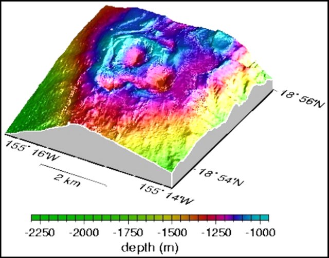 |
Figure 11. Three-dimensional bathymetric map of the southernmost two-thirds of the Lōʻihi summit platform. Courtesy of HVO web site. |
Investigators at the Monterey Bay Aquarium Research Institute (MBARI) have been studying Lōʻihi. When lava comes in contact with seawater, it cools so rapidly that it shatters into glass sand and rubble. When lava enters the sea under confined mixing conditions such as those within a lava tube, rapid expansion of seawater to steam in the tube can produce large basalt glass bubbles that shatter into curved, paper-thin, bubble-wall fragments known as "limu o Pele" (Pele's seaweed, figure 12). Such bubble-wall fragments and thin strands of volcanic glass, known as Pele's hair, have been recovered from Lōʻihi seamount and other deep-sea locations around Hawaii. Layered volcaniclastic deposits up to 11 m thick crop out along faults at the caldera's edge on Lōʻihi's summit. The layers include unconsolidated volcanic gravel, sand, silt, and mud. Fragments in volcaniclastic units include fluidal clasts, limu o Pele, highly vesicular to scoriaceous fragments, and Pele's hair (Clague and others, 2003; Clague and others, 2000).
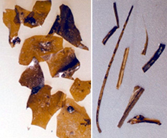 |
Figure 12. Fragments of limu o Pele (upper photo, largest diameters ~ 0.5 mm) and Pele's hair (lower photo, longest specimen is slightly over 1 cm), formed from lava bubbles during eruption (Clague, Davis, Bischoff, Dixon, and Geyer, 2000). Courtesy of MBARI, 2001. |
The high sulfur and carbon-dioxide contents of these basaltic glass shards suggest that they were erupted at great depth. These fragments indicate that submarine eruptions can be more violent than previously thought, and can produce features to depths of at least 4 km similar to those observed in shallow-water environments.
A December 2000 NOAA Research article (Malahoff, 2000) noted that "Three pit craters occupy the summit of Lōʻihi. The southernmost crater, Pele's Pit, formed during a two-week seismic swarm in 1996 that collapsed the hydrothermally active cone Pele's Vents. The new pit has steep walls with the floor located 200 meters below the rim of the crater. The crater floor and north slope are sites of spectacular and extensive hydrothermal venting with water temperatures ranging from 30°C to nearly 200°C. Diverse microbial mats surround the vents and cover the near vertical slopes of Pele's Pit."
New organisms identified at Lōʻihi include the bacteria, L2TR and Idiomarina loihiensis (a halophilic g-Proteobacterium (Donachie and others, 2003) and a shrimp, Opaepele loihi (Williams and Dobbs, 1995).
Embodying both the topic of limu o Pele and marine organisms, David Clague and colleagues at MBARI have identified foraminifera that incorporated volcanic bubble walls in their tests (figure 13). These were discussed on the MBARI website. "Benthic foraminifera often glue particles to their tests, perhaps for protection from predators. These particles may be sponge spicules, sand grains, or other detritus, depending on the materials available and the 'specialty' of the foram. In sediment cores from the Gorda Ridge, we found forams that 'specialized' in volcanic glass grains and others that 'specialized' in limu o Pele. They effectively concentrated the glass samples for us!"
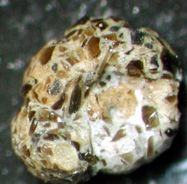 |
Figure 13. Benthic foraminifera with agglutinated limu o Pele (foram ~ 2 mm across). Image © MBARI 2003. |
References. Caplan-Auerbach, J., and Duennebier, F., 2001, Seismicity and velocity structure of Lōʻihi seamount from the 1996 earthquake swarm: Bulletin of the Seismological Society of America, v. 91, no. 2, p. 178-190.
Clague, D.A., Baiza, R., Head, J.W., III, and Davis, A.S., 2003, Pyroclastic and hydroclastic deposits on Lōʻihi Seamount, Hawaii, in Explosive Subaqueous Volcanism, White, J.D.L., Smellie, J.L., and Clague, D.A. (eds.): Geophysical Monograph 140, American Geophysical Union, p. 73-95.
Clague, D.A., Davis, A.S., Bischoff, J.L., Dixon, J.E., and Geyer, R., 2000, Lava bubble-wall fragments formed by submarine hydrovolcanic explosions on Lo'ihi Seamount and Kīlauea Volcano: Bulletin of Volcanology, v. 61, no. 7. p. 437-449.
Davis, A.S., Clague, D.A., Zierenberg, R.A., Wheat, C.G., and Cousens, B.L., 2003, Sulfide formation related to changes in the hydrothermal system on Lōʻihi Seamount, Hawai'i, following the seismic event in 1996: The Canadian Mineralogist, v. 41, p. 457-472.
Donachie, S.P., Shaobin, H., Todd, S.G., Malahoff, A., and Alam, M., 2003, Idiomarina loihiensis sp. nov., a halophilic ?-Proteobacterium from the Lo'ihi submarine volcano, Hawai'i: Int J Syst Evol Microbiol, v. 53, p. 1873-1879, DOI 10.1099/ijs.0.02701-0 (International Union of Microbiological Societies).
Malahoff, A., 2000, Lōʻihi submarine volcano: a natural extremeophile laboratory: U.S. Dept of Commerce, National Oceanic and Atmospheric Administration, Office of Oceanic and Atmospheric Research (http://www.oar.noaa.gov/spotlite/archive/spot_loihi.html), 12 October 2006.
Williams, A.B, and Dobbs, F.C, 1995, A new genus and species of caridean shrimp (Crustacea: Decapoda: Bresiliidae) from hydrothermal vents on Lōʻihi Seamount, Hawaii: Proceedings of the Biological Society of Washington, v. 108, p. 228-237.
Information Contacts: Hawaii Center for Volcanology, University of Hawaii at Manoa, Honolulu, HI (URL: http://www/soest.hawaii.edu/GG/HCV/loihi.html); U.S. Geological Survey Earthquake Information Center (NEIC) (URL: https://earthquake.usgs.gov/neis); Scripps Institution of Oceanography, Marine EM Laboratory (URL: http://marineemlab.ucsd.edu); Monterey Bay Aquarium Research Institute (MBARI), 7700 Sandholdt Road, Moss Landing, CA 95039-9664, USA (URL: http://www.mbari.org/); Hawaiian Volcano Observatory (HVO), U.S. Geological Survey, PO Box 51, Hawaii National Park, HI 96718, USA (URL: https://volcanoes.usgs.gov/observatories/hvo/); Alexander Malahoff, Institute of Geological and Nuclear Sciences Ltd. (GNS), Avalon, Lower Hutt, P.O. Box 30 368, New Zealand.
Seismic swarms during 2001-2006
K. H. Rubin of the University of Hawaii provided some of the following information concerning Lōʻihi volcano, noting that there hasn't been much activity reported over the last 10 years. The ocean bottom seismometer (OBS) died several months after installation in mid-1996 because the cable connecting it to land was not armored and thus failed early after deployment. However, using available seismic data from the OBS and the Hawaiian Volcano Observatory (HVO) land network, Caplan-Auerbach and others (2001), were able to develop a more precise crustal velocity model so that seismic events at Lōʻihi recorded by the land stations at Kīlauea can now be precisely located. Unfortunately, only large events (probably >M 3 or M 4) are detected.
Several papers were published on Lōʻihi by Schipper and others (2010, 2011) looking at a reworked pyroclastic section of unknown age on the summit platform and making inferences on eruptive conditions (especially on the conditions of vesiculation and fragmentation). The samples for their studies were collected during the last known geological dives to the summit by Hawaii Undersea Research Laboratory (HURL) and NOAA in 2007.
Seismic swarms during 2001-2006. The Lōʻihi website reported that a seismic swarm was detected at Lōʻihi's summit with earthquakes up to M 5.2 on 13 September 2001. Activity continued for a couple of weeks, with 4 events >M 4 at depths of 12-13 km. No >M 4 earthquakes were detected at Lōʻihi during 2002-2004. An M 4.3 earthquake occurred on 23 April 2005 at ~33 km depth beneath Lōʻihi, and earthquakes of M 5.1 and 5.4 occurred on 13 May and 17 July 2005, respectively, both at a depth of 44 km. The U.S. Geological Survey Advanced National Seismic System measured a small swarm of about 100 earthquakes (the largest 3 events were ~M 4, and between 12 and 28 km deep) that occurred beneath Lōʻihi on 7 December 2005. A more recent earthquake (estimated M 4.7) occurred on 18 January 2006, roughly midway between Lōʻihi and Pahala (on the S coast of the island of Hawaii).
References. Caplan-Auerbach, J., and Duennebier, F.K., 2001, Seismicity and Velocity Structure of Lōʻihi Seamount from the 1996 Earthquake Swarm, Bulletin of the Seismological Society of America, v. 91, no. 2, p. 178-190.
Rubin, K.H., Soule, S.A., Chadwick Jr., W.W., Fornari, D.J., Clague, D.A., Embley, R.W., Baker, E.T., Perfit, M.R., Caress, D.W., and Dziak, R.P., 2012, Volcanic eruptions in the deep sea, Oceanography, v. 25, no. 1, p. 142-157.
Schipper, C.I., White, J.D.L., and Houghton, B.F., 2010, Syn- and post-fragmentation textures in submarine pyroclasts from Lo`ihi Seamount, Hawai`i, Journal of Volcanology and Geothermal Research, v. 191, issues 3-4, p. 93-106.
Schipper, C.I., White, J.D.L., and Houghton, B.F., 2011, Textural, geochemical, and volatile evidence for a Strombolian-like eruption sequence at Lo`ihi Seamount, Hawai`i, Journal of Volcanology and Geothermal Research, v. 207, issues 1-2, p. 16-32.
Information Contacts: Lo`ihi Volcano website (URL: http://www.soest.hawaii.edu/GG/HCV/loihi.html); K. H. Rubin, Department of Geology and Geophysics, School of Ocean and Earth Science and Technology (SOEST), University of Hawaii at Manoa, Honolulu, HI (URL: http://www/soest.hawaii.edu/GG); U.S. Geological Survey Earthquake Information Center (NEIC) (URL: https://earthquake.usgs.gov/neis); Hawaiian Volcano Observatory (HVO), U.S. Geological Survey, PO Box 51, Hawaii National Park, HI 96718, USA (URL: https://volcanoes.usgs.gov/observatories/hvo/).
|
|
||||||||||||||||||||||||||||
There is data available for 4 confirmed eruptive periods.
1996 Feb 25 ± 30 days - 1996 Aug 9 (?) Confirmed Eruption (Explosive / Effusive) VEI: 0
| Episode 1 | Eruption (Explosive / Effusive) | ||||||||||||||||||||||||
|---|---|---|---|---|---|---|---|---|---|---|---|---|---|---|---|---|---|---|---|---|---|---|---|---|
| 1996 Feb 25 ± 30 days - 1996 Aug 9 (?) | Evidence from Observations: Reported | |||||||||||||||||||||||
|
List of 3 Events for Episode 1
|
||||||||||||||||||||||||
[ 1986 Sep 20 - 1986 Sep 20 ] Uncertain Eruption
| Episode 1 | Eruption (Explosive / Effusive) | |||||||||||||||||||
|---|---|---|---|---|---|---|---|---|---|---|---|---|---|---|---|---|---|---|---|
| 1986 Sep 20 - 1986 Sep 20 | Evidence from Unknown | ||||||||||||||||||
|
List of 2 Events for Episode 1
|
|||||||||||||||||||
[ 1984 Nov 11 - 1985 Jan 21 ] Uncertain Eruption
| Episode 1 | Eruption (Explosive / Effusive) | |||||||||||||||||||
|---|---|---|---|---|---|---|---|---|---|---|---|---|---|---|---|---|---|---|---|
| 1984 Nov 11 - 1985 Jan 21 | Evidence from Unknown | ||||||||||||||||||
|
List of 2 Events for Episode 1
|
|||||||||||||||||||
[ 1975 Aug 24 (?) - 1975 Nov 16 ± 15 days ] Uncertain Eruption
| Episode 1 | Eruption (Explosive / Effusive) | |||||||||||||||||||||||||||||
|---|---|---|---|---|---|---|---|---|---|---|---|---|---|---|---|---|---|---|---|---|---|---|---|---|---|---|---|---|---|
| 1975 Aug 24 (?) - 1975 Nov 16 ± 15 days | Evidence from Unknown | ||||||||||||||||||||||||||||
|
List of 4 Events for Episode 1
|
|||||||||||||||||||||||||||||
[ 1971 Sep 17 - 1972 Sep 16 ± 15 days ] Uncertain Eruption
| Episode 1 | Eruption (Explosive / Effusive) | |||||||||||||||||||||||||||||
|---|---|---|---|---|---|---|---|---|---|---|---|---|---|---|---|---|---|---|---|---|---|---|---|---|---|---|---|---|---|
| 1971 Sep 17 - 1972 Sep 16 ± 15 days | Evidence from Unknown | ||||||||||||||||||||||||||||
|
List of 4 Events for Episode 1
|
|||||||||||||||||||||||||||||
0050 BCE ± 3000 years Confirmed Eruption (Explosive / Effusive) VEI: 0
| Episode 1 | Eruption (Explosive / Effusive) | |||||||||||||||||||
|---|---|---|---|---|---|---|---|---|---|---|---|---|---|---|---|---|---|---|---|
| 0050 BCE ± 3000 years - Unknown | Evidence from Isotopic: K/Ar | ||||||||||||||||||
|
List of 2 Events for Episode 1
|
|||||||||||||||||||
5050 BCE ± 5000 years Confirmed Eruption (Explosive / Effusive) VEI: 0
| Episode 1 | Eruption (Explosive / Effusive) | |||||||||||||||||||
|---|---|---|---|---|---|---|---|---|---|---|---|---|---|---|---|---|---|---|---|
| 5050 BCE ± 5000 years - Unknown | Evidence from Isotopic: K/Ar | ||||||||||||||||||
|
List of 2 Events for Episode 1
|
|||||||||||||||||||
7050 BCE ± 7000 years Confirmed Eruption (Explosive / Effusive) VEI: 0
| Episode 1 | Eruption (Explosive / Effusive) | East flank? | ||||||||||||||||||
|---|---|---|---|---|---|---|---|---|---|---|---|---|---|---|---|---|---|---|---|
| 7050 BCE ± 7000 years - Unknown | Evidence from Isotopic: K/Ar | ||||||||||||||||||
|
List of 2 Events for Episode 1 at East flank?
|
|||||||||||||||||||
This compilation of synonyms and subsidiary features may not be comprehensive. Features are organized into four major categories: Cones, Craters, Domes, and Thermal Features. Synonyms of features appear indented below the primary name. In some cases additional feature type, elevation, or location details are provided.
Synonyms |
| Lōʻihi |
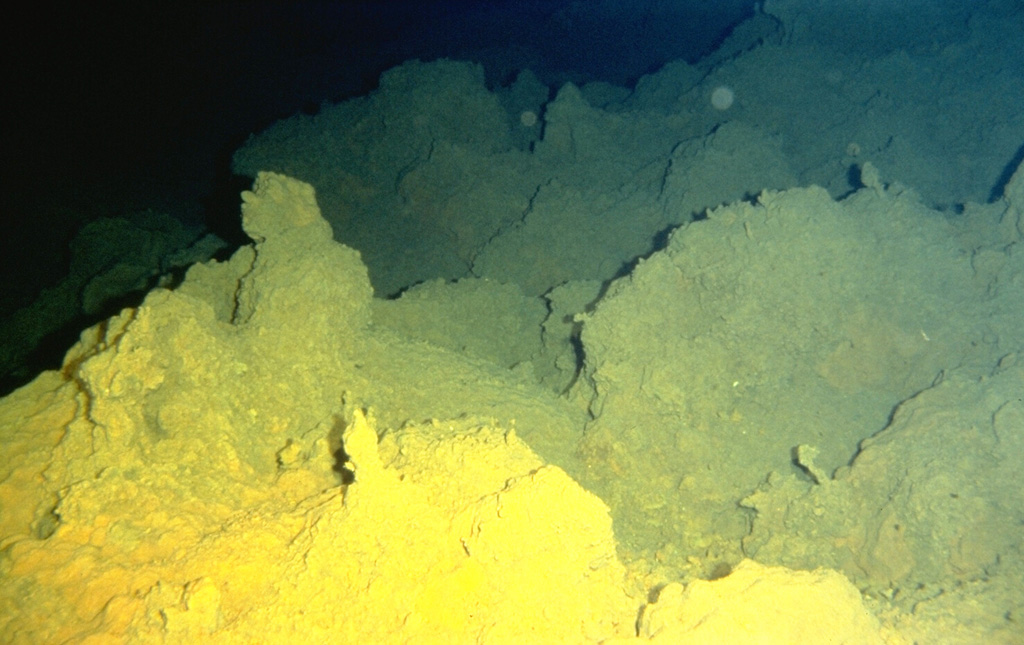
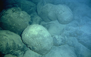 Submarine extrusion of lava produces a characteristic "pillow lava" morphology, as seen here on Lōʻihi seamount SE of the island of Hawaii. Thin streams of molten lava are extruded in a form that resembles toothpaste squeezed out of a tube. The outer surface of the lava is quickly chilled by the water and solidifies, while the interior remains molten and continues to flow, lengthening the tubes.
  Sulfur deposited from fumarolic vents coats lava flows on Lōʻihi seamount. Lōʻihi, the youngest Hawaiian volcano, rises to within 975 m of the sea surface 35 km off the SE coast of the island of Hawaii. Two rift zones, oriented N-S, give the volcano an elongated form, and prompted its name, which is the Hawaiian word for "long." Fresh, sediment-free lava flows indicate the young age of the submarine volcano, and seismic swarms related to intrusive or eruptive activity have been recorded frequently.
The following 2 samples associated with this volcano can be found in the Smithsonian's NMNH Department of Mineral Sciences collections, and may be availble for research (contact the Rock and Ore Collections Manager). Catalog number links will open a window with more information.
| Catalog Number | Sample Description | Lava Source | Collection Date |
|---|---|---|---|
| NMNH 116076 | Basalt | -- | -- |
| NMNH 116077 | Basalt | -- | -- |
| Copernicus Browser | The Copernicus Browser replaced the Sentinel Hub Playground browser in 2023, to provide access to Earth observation archives from the Copernicus Data Space Ecosystem, the main distribution platform for data from the EU Copernicus missions. |
| MIROVA | Middle InfraRed Observation of Volcanic Activity (MIROVA) is a near real time volcanic hot-spot detection system based on the analysis of MODIS (Moderate Resolution Imaging Spectroradiometer) data. In particular, MIROVA uses the Middle InfraRed Radiation (MIR), measured over target volcanoes, in order to detect, locate and measure the heat radiation sourced from volcanic activity. |
| MODVOLC Thermal Alerts | Using infrared satellite Moderate Resolution Imaging Spectroradiometer (MODIS) data, scientists at the Hawai'i Institute of Geophysics and Planetology, University of Hawai'i, developed an automated system called MODVOLC to map thermal hot-spots in near real time. For each MODIS image, the algorithm automatically scans each 1 km pixel within it to check for high-temperature hot-spots. When one is found the date, time, location, and intensity are recorded. MODIS looks at every square km of the Earth every 48 hours, once during the day and once during the night, and the presence of two MODIS sensors in space allows at least four hot-spot observations every two days. Each day updated global maps are compiled to display the locations of all hot spots detected in the previous 24 hours. There is a drop-down list with volcano names which allow users to 'zoom-in' and examine the distribution of hot-spots at a variety of spatial scales. |
|
WOVOdat
Single Volcano View Temporal Evolution of Unrest Side by Side Volcanoes |
WOVOdat is a database of volcanic unrest; instrumentally and visually recorded changes in seismicity, ground deformation, gas emission, and other parameters from their normal baselines. It is sponsored by the World Organization of Volcano Observatories (WOVO) and presently hosted at the Earth Observatory of Singapore.
GVMID Data on Volcano Monitoring Infrastructure The Global Volcano Monitoring Infrastructure Database GVMID, is aimed at documenting and improving capabilities of volcano monitoring from the ground and space. GVMID should provide a snapshot and baseline view of the techniques and instrumentation that are in place at various volcanoes, which can be use by volcano observatories as reference to setup new monitoring system or improving networks at a specific volcano. These data will allow identification of what monitoring gaps exist, which can be then targeted by remote sensing infrastructure and future instrument deployments. |
| Volcanic Hazard Maps | The IAVCEI Commission on Volcanic Hazards and Risk has a Volcanic Hazard Maps database designed to serve as a resource for hazard mappers (or other interested parties) to explore how common issues in hazard map development have been addressed at different volcanoes, in different countries, for different hazards, and for different intended audiences. In addition to the comprehensive, searchable Volcanic Hazard Maps Database, this website contains information about diversity of volcanic hazard maps, illustrated using examples from the database. This site is for educational purposes related to volcanic hazard maps. Hazard maps found on this website should not be used for emergency purposes. For the most recent, official hazard map for a particular volcano, please seek out the proper institutional authorities on the matter. |
| IRIS seismic stations/networks | Incorporated Research Institutions for Seismology (IRIS) Data Services map showing the location of seismic stations from all available networks (permanent or temporary) within a radius of 0.18° (about 20 km at mid-latitudes) from the given location of Kama'ehuakanaloa. Users can customize a variety of filters and options in the left panel. Note that if there are no stations are known the map will default to show the entire world with a "No data matched request" error notice. |
| UNAVCO GPS/GNSS stations | Geodetic Data Services map from UNAVCO showing the location of GPS/GNSS stations from all available networks (permanent or temporary) within a radius of 20 km from the given location of Kama'ehuakanaloa. Users can customize the data search based on station or network names, location, and time window. Requires Adobe Flash Player. |
| DECADE Data | The DECADE portal, still in the developmental stage, serves as an example of the proposed interoperability between The Smithsonian Institution's Global Volcanism Program, the Mapping Gas Emissions (MaGa) Database, and the EarthChem Geochemical Portal. The Deep Earth Carbon Degassing (DECADE) initiative seeks to use new and established technologies to determine accurate global fluxes of volcanic CO2 to the atmosphere, but installing CO2 monitoring networks on 20 of the world's 150 most actively degassing volcanoes. The group uses related laboratory-based studies (direct gas sampling and analysis, melt inclusions) to provide new data for direct degassing of deep earth carbon to the atmosphere. |
| Large Eruptions of Kama'ehuakanaloa | Information about large Quaternary eruptions (VEI >= 4) is cataloged in the Large Magnitude Explosive Volcanic Eruptions (LaMEVE) database of the Volcano Global Risk Identification and Analysis Project (VOGRIPA). |
| EarthChem | EarthChem develops and maintains databases, software, and services that support the preservation, discovery, access and analysis of geochemical data, and facilitate their integration with the broad array of other available earth science parameters. EarthChem is operated by a joint team of disciplinary scientists, data scientists, data managers and information technology developers who are part of the NSF-funded data facility Integrated Earth Data Applications (IEDA). IEDA is a collaborative effort of EarthChem and the Marine Geoscience Data System (MGDS). |

