Low seismicity, no fumarolic activity, and no crater changes
Seismic activity was monitored on 22-24 April using one station located at 4,480 m elevation on the S flank. The station consisted of a 1-Hz vertical component seismometer, operating at 78 dB amplification with a band-pass filter between 0.3 and 30.0 Hz. The station registered five B-type events within a 5.5 hour time period on 23 April, and three events within 15 minutes of each other on 24 April. Coda duration was 10-18 seconds long; frequencies were in the 3-6 Hz range. Maximum peak-to-peak amplitudes measured 1-3 mm.
Observers who ascended to the summit found no fumarolic activity. Crater morphology was unchanged since visits in October 1992 and 1989. Water discharge from the "La virgen" spring at 4,400 m elevation had decreased to 0.5 liters/hour from 10 liters/hour in 1992.
Information Contacts: Guillermo González-Pomposo1 and Carlos Valdés-González, Departamento de Sismología y Volcanología, Instituto de Geofísica, UNAM, Cd. Universitaría, 04510 D.F., México; 1 Also at Benemérita Univ Autótonoma de Puebla, México.
The Global Volcanism Program has no Weekly Reports available for Pico de Orizaba.
Reports are organized chronologically and indexed below by Month/Year (Publication Volume:Number), and include a one-line summary. Click on the index link or scroll down to read the reports.
Seismic monitoring finds little activity
During four days of seismic monitoring at Pico de Orizaba (10-13 October), only a single A-type event was recorded by an analog seismic station at 4,680 m above sea level on the S flank. The M 2.7 shock, on 12 October at 0124, had an S-P of 1.5 seconds, consistent with a depth of 8 km. The station, a 1-component (Z) 1-second seismometer, was operated at 72 dB amplification at 0.3-30 Hz. No fumarolic activity was observed and crater morphology has remained unchanged since the team's initial observation in 1989. Geologists plan a continued monitoring program.
Information Contacts: G. Pomposo, Benemérita University, Puebla; A. Martín del Pozzo, UNAM, México D.F.
Low seismicity, no fumarolic activity, and no crater changes
Seismic activity was monitored on 22-24 April using one station located at 4,480 m elevation on the S flank. The station consisted of a 1-Hz vertical component seismometer, operating at 78 dB amplification with a band-pass filter between 0.3 and 30.0 Hz. The station registered five B-type events within a 5.5 hour time period on 23 April, and three events within 15 minutes of each other on 24 April. Coda duration was 10-18 seconds long; frequencies were in the 3-6 Hz range. Maximum peak-to-peak amplitudes measured 1-3 mm.
Observers who ascended to the summit found no fumarolic activity. Crater morphology was unchanged since visits in October 1992 and 1989. Water discharge from the "La virgen" spring at 4,400 m elevation had decreased to 0.5 liters/hour from 10 liters/hour in 1992.
Information Contacts: Guillermo González-Pomposo1 and Carlos Valdés-González, Departamento de Sismología y Volcanología, Instituto de Geofísica, UNAM, Cd. Universitaría, 04510 D.F., México; 1 Also at Benemérita Univ Autótonoma de Puebla, México.
This compilation of synonyms and subsidiary features may not be comprehensive. Features are organized into four major categories: Cones, Craters, Domes, and Thermal Features. Synonyms of features appear indented below the primary name. In some cases additional feature type, elevation, or location details are provided.
Synonyms |
||||
| Citlaltépetl | Citlaltepec | Poyauhtécatl | Poiauhtécatl | Zeuctépetl | Teuctépetl | Pojautécatl | ||||
Cones |
||||
| Feature Name | Feature Type | Elevation | Latitude | Longitude |
| Espolón de Oro | Stratovolcano | |||
| Negra, Sierra | Stratovolcano | 4580 m | ||
| Pico | Stratovolcano | 4850 m | ||
| Torrecillas | Stratovolcano | |||
Craters |
||||
| Feature Name | Feature Type | Elevation | Latitude | Longitude |
| Teteltzingo | Crater | |||
Domes |
||||
| Feature Name | Feature Type | Elevation | Latitude | Longitude |
| Chichihuale, Cerro | Dome | |||
| Chichimeco | Dome | 4160 m | 19° 4' 0" N | 97° 14' 0" W |
| Colorado, Cerro | Dome | |||
|
|
||||||||||||||||||||||||||
There is data available for 23 confirmed Holocene eruptive periods.
1846 Confirmed Eruption Max VEI: 2
| Episode 1 | Eruption Episode | |||||||||||||||||||||||||
|---|---|---|---|---|---|---|---|---|---|---|---|---|---|---|---|---|---|---|---|---|---|---|---|---|---|
| 1846 - Unknown | Evidence from Observations: Reported | ||||||||||||||||||||||||
|
List of 3 Events for Episode 1
| |||||||||||||||||||||||||
1687 Confirmed Eruption Max VEI: 2
| Episode 1 | Eruption Episode | ||||||||||||||||||||
|---|---|---|---|---|---|---|---|---|---|---|---|---|---|---|---|---|---|---|---|---|
| 1687 - Unknown | Evidence from Observations: Reported | |||||||||||||||||||
|
List of 2 Events for Episode 1
| ||||||||||||||||||||
1613 Confirmed Eruption Max VEI: 0
| Episode 1 | Eruption Episode | ||||||||||||||||||||
|---|---|---|---|---|---|---|---|---|---|---|---|---|---|---|---|---|---|---|---|---|
| 1613 - Unknown | Evidence from Observations: Reported | |||||||||||||||||||
|
List of 2 Events for Episode 1
| ||||||||||||||||||||
1569 - 1589 Confirmed Eruption Max VEI: 2
| Episode 1 | Eruption Episode | ||||||||||||||||||||
|---|---|---|---|---|---|---|---|---|---|---|---|---|---|---|---|---|---|---|---|---|
| 1569 - 1589 | Evidence from Observations: Reported | |||||||||||||||||||
|
List of 2 Events for Episode 1
| ||||||||||||||||||||
1566 Confirmed Eruption Max VEI: 2
| Episode 1 | Eruption Episode | |||||||||||||||||||||||||
|---|---|---|---|---|---|---|---|---|---|---|---|---|---|---|---|---|---|---|---|---|---|---|---|---|---|
| 1566 - Unknown | Evidence from Observations: Reported | ||||||||||||||||||||||||
|
List of 3 Events for Episode 1
| |||||||||||||||||||||||||
1545 - 1555 (?) ± 10 years Confirmed Eruption Max VEI: 2
| Episode 1 | Eruption Episode | ||||||||||||||||||||||||||||||
|---|---|---|---|---|---|---|---|---|---|---|---|---|---|---|---|---|---|---|---|---|---|---|---|---|---|---|---|---|---|---|
| 1545 - 1555 (?) ± 10 years | Evidence from Observations: Reported | |||||||||||||||||||||||||||||
|
List of 4 Events for Episode 1
| ||||||||||||||||||||||||||||||
[ 1533 - 1539 ] Uncertain Eruption
| Episode 1 | Eruption Episode | |||||||||||||||||||||||||
|---|---|---|---|---|---|---|---|---|---|---|---|---|---|---|---|---|---|---|---|---|---|---|---|---|---|
| 1533 - 1539 | Evidence from Unknown | ||||||||||||||||||||||||
|
List of 3 Events for Episode 1
| |||||||||||||||||||||||||
[ 1351 ] Uncertain Eruption
| Episode 1 | Eruption Episode | ||||||||||||||||||||
|---|---|---|---|---|---|---|---|---|---|---|---|---|---|---|---|---|---|---|---|---|
| 1351 - Unknown | Evidence from Unknown | |||||||||||||||||||
|
List of 2 Events for Episode 1
| ||||||||||||||||||||
1260 ± 50 years Confirmed Eruption Max VEI: 3
| Episode 1 | Eruption Episode | |||||||||||||||||||||||||
|---|---|---|---|---|---|---|---|---|---|---|---|---|---|---|---|---|---|---|---|---|---|---|---|---|---|
| 1260 ± 50 years - Unknown | Evidence from Isotopic: 14C (uncalibrated) | ||||||||||||||||||||||||
|
List of 3 Events for Episode 1
| |||||||||||||||||||||||||
[ 1187 ] Uncertain Eruption
| Episode 1 | Eruption Episode | ||||||||||||||||||||
|---|---|---|---|---|---|---|---|---|---|---|---|---|---|---|---|---|---|---|---|---|
| 1187 - Unknown | Evidence from Unknown | |||||||||||||||||||
|
List of 2 Events for Episode 1
| ||||||||||||||||||||
1175 Confirmed Eruption Max VEI: 3 (?)
| Episode 1 | Eruption Episode | |||||||||||||||||||||||||
|---|---|---|---|---|---|---|---|---|---|---|---|---|---|---|---|---|---|---|---|---|---|---|---|---|---|
| 1175 - Unknown | Evidence from Correlation: Anthropology | ||||||||||||||||||||||||
|
List of 3 Events for Episode 1
| |||||||||||||||||||||||||
[ 1157 ] Uncertain Eruption
| Episode 1 | Eruption Episode | ||||||||||||||||||||
|---|---|---|---|---|---|---|---|---|---|---|---|---|---|---|---|---|---|---|---|---|
| 1157 - Unknown | Evidence from Unknown | |||||||||||||||||||
|
List of 2 Events for Episode 1
| ||||||||||||||||||||
0220 ± 75 years Confirmed Eruption Max VEI: 3
| Episode 1 | Eruption Episode | |||||||||||||||||||||||||
|---|---|---|---|---|---|---|---|---|---|---|---|---|---|---|---|---|---|---|---|---|---|---|---|---|---|
| 0220 ± 75 years - Unknown | Evidence from Isotopic: 14C (uncalibrated) | ||||||||||||||||||||||||
|
List of 3 Events for Episode 1
| |||||||||||||||||||||||||
0140 ± 50 years Confirmed Eruption Max VEI: 3
| Episode 1 | Eruption Episode | ||||||||||||||||||||
|---|---|---|---|---|---|---|---|---|---|---|---|---|---|---|---|---|---|---|---|---|
| 0140 ± 50 years - Unknown | Evidence from Isotopic: 14C (uncalibrated) | |||||||||||||||||||
|
List of 2 Events for Episode 1
| ||||||||||||||||||||
0090 ± 40 years Confirmed Eruption Max VEI: 3
| Episode 1 | Eruption Episode | |||||||||||||||||||||||||||||||||||||||||||||
|---|---|---|---|---|---|---|---|---|---|---|---|---|---|---|---|---|---|---|---|---|---|---|---|---|---|---|---|---|---|---|---|---|---|---|---|---|---|---|---|---|---|---|---|---|---|
| 0090 ± 40 years - Unknown | Evidence from Isotopic: 14C (uncalibrated) | ||||||||||||||||||||||||||||||||||||||||||||
|
List of 7 Events for Episode 1
| |||||||||||||||||||||||||||||||||||||||||||||
0040 ± 40 years Confirmed Eruption Max VEI: 3
| Episode 1 | Eruption Episode | |||||||||||||||||||||||||
|---|---|---|---|---|---|---|---|---|---|---|---|---|---|---|---|---|---|---|---|---|---|---|---|---|---|
| 0040 ± 40 years - Unknown | Evidence from Isotopic: 14C (uncalibrated) | ||||||||||||||||||||||||
|
List of 3 Events for Episode 1
| |||||||||||||||||||||||||
0780 BCE ± 50 years Confirmed Eruption Max VEI: 3
| Episode 1 | Eruption Episode | |||||||||||||||||||||||||
|---|---|---|---|---|---|---|---|---|---|---|---|---|---|---|---|---|---|---|---|---|---|---|---|---|---|
| 0780 BCE ± 50 years - Unknown | Evidence from Isotopic: 14C (uncalibrated) | ||||||||||||||||||||||||
|
List of 3 Events for Episode 1
| |||||||||||||||||||||||||
1500 BCE ± 75 years Confirmed Eruption Max VEI: 3
| Episode 1 | Eruption Episode | ||||||||||||||||||||
|---|---|---|---|---|---|---|---|---|---|---|---|---|---|---|---|---|---|---|---|---|
| 1500 BCE ± 75 years - Unknown | Evidence from Isotopic: 14C (uncalibrated) | |||||||||||||||||||
|
List of 2 Events for Episode 1
| ||||||||||||||||||||
2110 BCE ± 100 years Confirmed Eruption Max VEI: 3
| Episode 1 | Eruption Episode | ||||||||||||||||||||
|---|---|---|---|---|---|---|---|---|---|---|---|---|---|---|---|---|---|---|---|---|
| 2110 BCE ± 100 years - Unknown | Evidence from Isotopic: 14C (uncalibrated) | |||||||||||||||||||
|
List of 2 Events for Episode 1
| ||||||||||||||||||||
2300 BCE ± 75 years Confirmed Eruption Max VEI: 4
| Episode 1 | Eruption Episode | La Perla unit | ||||||||||||||||||||||||||||||||||||||||||||
|---|---|---|---|---|---|---|---|---|---|---|---|---|---|---|---|---|---|---|---|---|---|---|---|---|---|---|---|---|---|---|---|---|---|---|---|---|---|---|---|---|---|---|---|---|---|
| 2300 BCE ± 75 years - Unknown | Evidence from Isotopic: 14C (uncalibrated) | ||||||||||||||||||||||||||||||||||||||||||||
|
List of 7 Events for Episode 1 at La Perla unit
| |||||||||||||||||||||||||||||||||||||||||||||
2500 BCE ± 75 years Confirmed Eruption Max VEI: 3
| Episode 1 | Eruption Episode | |||||||||||||||||||||||||
|---|---|---|---|---|---|---|---|---|---|---|---|---|---|---|---|---|---|---|---|---|---|---|---|---|---|
| 2500 BCE ± 75 years - Unknown | Evidence from Isotopic: 14C (uncalibrated) | ||||||||||||||||||||||||
|
List of 3 Events for Episode 1
| |||||||||||||||||||||||||
2780 BCE ± 75 years Confirmed Eruption Max VEI: 3
| Episode 1 | Eruption Episode | |||||||||||||||||||||||||
|---|---|---|---|---|---|---|---|---|---|---|---|---|---|---|---|---|---|---|---|---|---|---|---|---|---|
| 2780 BCE ± 75 years - Unknown | Evidence from Isotopic: 14C (uncalibrated) | ||||||||||||||||||||||||
|
List of 3 Events for Episode 1
| |||||||||||||||||||||||||
4690 BCE ± 300 years Confirmed Eruption Max VEI: 3
| Episode 1 | Eruption Episode | |||||||||||||||||||||||||||||||||||||||||||||
|---|---|---|---|---|---|---|---|---|---|---|---|---|---|---|---|---|---|---|---|---|---|---|---|---|---|---|---|---|---|---|---|---|---|---|---|---|---|---|---|---|---|---|---|---|---|
| 4690 BCE ± 300 years - Unknown | Evidence from Isotopic: 14C (uncalibrated) | ||||||||||||||||||||||||||||||||||||||||||||
|
List of 7 Events for Episode 1
| |||||||||||||||||||||||||||||||||||||||||||||
6220 BCE ± 75 years Confirmed Eruption Max VEI: 3
| Episode 1 | Eruption Episode | ||||||||||||||||||||||||||||||||||||||||
|---|---|---|---|---|---|---|---|---|---|---|---|---|---|---|---|---|---|---|---|---|---|---|---|---|---|---|---|---|---|---|---|---|---|---|---|---|---|---|---|---|
| 6220 BCE ± 75 years - Unknown | Evidence from Isotopic: 14C (uncalibrated) | |||||||||||||||||||||||||||||||||||||||
|
List of 6 Events for Episode 1
| ||||||||||||||||||||||||||||||||||||||||
6710 BCE ± 150 years Confirmed Eruption Max VEI: 5 (?)
| Episode 1 | Eruption Episode | Upper Citlaltépetl ignimbrite | ||||||||||||||||||||||||||||||||||||||||||||
|---|---|---|---|---|---|---|---|---|---|---|---|---|---|---|---|---|---|---|---|---|---|---|---|---|---|---|---|---|---|---|---|---|---|---|---|---|---|---|---|---|---|---|---|---|---|
| 6710 BCE ± 150 years - Unknown | Evidence from Isotopic: 14C (uncalibrated) | ||||||||||||||||||||||||||||||||||||||||||||
|
List of 7 Events for Episode 1 at Upper Citlaltépetl ignimbrite
| |||||||||||||||||||||||||||||||||||||||||||||
7030 BCE ± 50 years Confirmed Eruption Max VEI: 4
| Episode 1 | Eruption Episode | Lower Citlaltépetl ignimbrite | |||||||||||||||||||||||||||||||||||||||||||||||||
|---|---|---|---|---|---|---|---|---|---|---|---|---|---|---|---|---|---|---|---|---|---|---|---|---|---|---|---|---|---|---|---|---|---|---|---|---|---|---|---|---|---|---|---|---|---|---|---|---|---|---|
| 7030 BCE ± 50 years - Unknown | Evidence from Isotopic: 14C (uncalibrated) | |||||||||||||||||||||||||||||||||||||||||||||||||
|
List of 8 Events for Episode 1 at Lower Citlaltépetl ignimbrite
| ||||||||||||||||||||||||||||||||||||||||||||||||||
7530 BCE ± 40 years Confirmed Eruption
| Episode 1 | Eruption Episode | ||||||||||||||||||||
|---|---|---|---|---|---|---|---|---|---|---|---|---|---|---|---|---|---|---|---|---|
| 7530 BCE ± 40 years - Unknown | Evidence from Isotopic: 14C (uncalibrated) | |||||||||||||||||||
|
List of 2 Events for Episode 1
| ||||||||||||||||||||
There is no Deformation History data available for Pico de Orizaba.
There is no Emissions History data available for Pico de Orizaba.
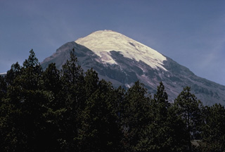 Pico de Orizaba (Volcán Citlaltépetl) rises to 5675 m at the southern end of volcanic chain the extends north to Cofre de Perote volcano. Orizaba is seen here from its NW flank with the snow-free peak of Sarcofago halfway down the left skyline. Periodic major explosions during the Holocene from North America's highest volcano were separated by long quiescent periods. Eruptions during the past 5000 years have primarily produced dacitic lava flows. Historical activity has consisted of minor ash eruptions and the extrusion of viscous lava flows.
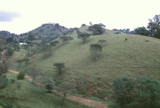 These large hills on the outskirts of the city of Huatusco, 35 km from Orizaba, are hummocks of the Jamapa debris avalanche and debris flow deposit, which covers 350 km2. The avalanche occurred during the late Pleistocene by collapse of the northern side of Torrecillas volcano, a predecessor to Orizaba, and created a 3.5-km-wide horseshoe-shaped scarp. The rapidly moving avalanche was able to ride up and over a ridge into drainages that do not originate from Orizaba.
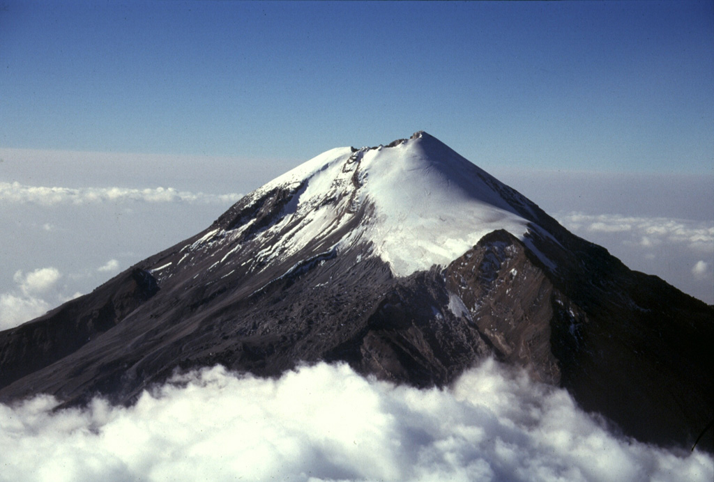
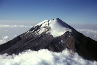 Pico de Orizaba (Volcán Citlaltépetl) rises 4,500 m above the Gulf of Mexico coastal plain. Its summit contained a 500-m-wide crater that was 300 m deep at the time of this 1997 photo. It is seen here from the NNE with the Jamapa glacier to the right above the NW-flank peak of Sarcofago (right center). The present summit cone was constructed during the Holocene, overtopping previously collapsed edifices.
 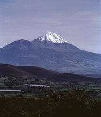 Pico de Orizaba, also known as Citlaltépetl ("Mountain of the Star") is seen here from the south. The snow-free peak to the left is Sierra Negra, a Pleistocene volcano that was active simultaneously with Orizaba. These volcanoes mark the southernmost extent of the Cofre de Perote-Pico de Orizaba volcanic chain.
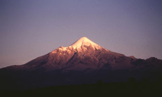 The evening sun illuminates the Pico de Orizaba western flank. The smaller peak to the left is the NW-flank peak of Sarcofago. The NW-dipping lavas of Sarcofago, which is part of the Espolón de Oro edifice, were exposed by edifice collapse. The collapse event forming a horseshoe-shaped crater, inside which the modern cone was constructed.
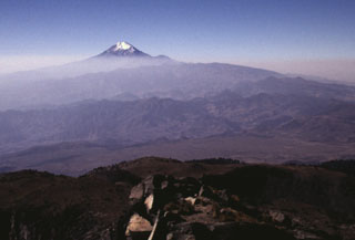 The N-S-trending Cofre de Perote-Pico de Orizaba volcanic chain is perpendicular to the trend of the Mexican Volcanic Belt. This view looking southward from the Cofre de Perote summit towards glacier-capped Pico de Orizaba in the background shows two lesser known volcanic complexes in between. The La Gloria volcanic field, also known as the Desconocido-Tecomales volcanic field, forms the eroded area in the center of the photo, and Las Cumbres volcano is the broad range that extends from in front of Orizaba to the right-center horizon.
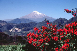 Pico de Orizaba volcano towers above ridges of Cretaceous limestone on its ENE flank. The glaciated volcano was constructed during three stages and has undergone edifice collapse on several occasions. Collapse of the initial Torrecillas edifice during the Pleistocene produced the massive Jamapa debris avalanche. It traveled down the Jamapa river and overtopped gaps in limestone foothills to reach the current area of the city of Huatusco, beyond where this photo was taken.
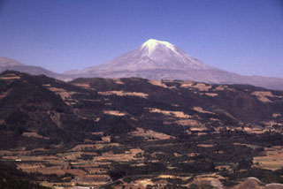 Pico de Orizaba volcano rises above the escarpment at the eastern margin of the Mexican Altiplano. It is seen here from the SE, along the road between Puebla and Orizaba. Like other volcanoes of the Pico de Orizaba-Cofre de Perote chain, deposits of Orizaba are asymmetrically distributed around the summit vent, and extend farther to the east towards the coastal plain.
 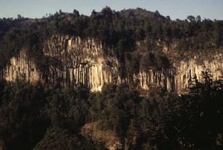 A massive columnar jointed lava flow is exposed in a valley NE of Orizaba volcano. The roughly 530,000-year-old Calcahualco lava flow was erupted during the Torrecillas stage, from the first of three major volcanic edifices forming the volcano. The source vent of this flow is now buried.
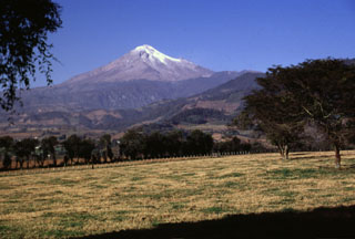 Like other volcanoes in the Cofre de Perote-Pico de Orizaba chain, Orizaba was constructed on the edge of the Altiplano and consequently has higher relief on the eastern side facing the Atlantic coastal plain. Glaciated Orizaba towers 4,200 m above fields near the town of Coscomatepec on its eastern flank. The valley to the left was impacted by the voluminous clay-rich Tetelzingo debris avalanche and lahar during the late Pleistocene.
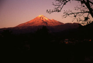 Pico de Orizaba volcano is seen here at sunrise above the town of Calcahualco. The volcano is named for the city of Orizaba below its SE flank, but is also known by the Aztec name of Citlaltépetl (Star Mountain). The volcano has a rich cultural history. Its lower slopes host Aztec villages, pyramids, and temples, and it is depicted in Aztec hieroglyphics.
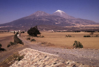 Pico de Orizaba volcano is seen here from the south, with snow-free Sierra Negra volcano to its left. Sierra Negra is the southernmost major vent of the roughly NNE-SSW-trending Pico de Orizaba-Cofre de Perote volcanic chain. The construction of Sierra Negra was contemporaneous with the mid-Pleistocene early stages in the formation of Orizaba volcano. Sierra Negra is composed largely of lava flows and produced numerous pyroclastic flows mainly to the SW and W.
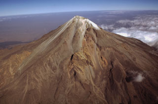 México's highest volcano, Pico de Orizaba, is seen here in an aerial view from the SE. The modern Citlaltépetl cone, marking the upper part of the volcano, was constructed within horseshoe-shaped scarps formed by previous edifice collapse events. The orange-brown ridges at the middle left and center are remnants of the oldest edifice, Torrecillas. The lighter-colored area between these two ridges is a thick, historical, lava flow that was erupted from the modern cone.
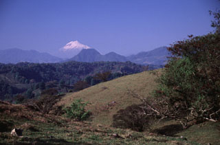 Glaciated Pico de Orizaba (Citlaltépetl) rises 50 km to the SW above rolling terrain south of the town of Xico, on the lower flanks of Cofre de Perote.
 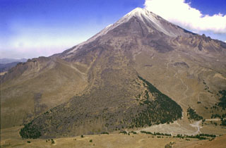 The lava flow descended the SW flank of Pico de Orizaba is about 110 m thick and up to 1.3 km wide at its terminus 5.5 km from the summit, and. has at least eight individual flow lobes. A portion of the flow that was diverted by topography to the west can be seen half-way up the flank. The smaller peak on the lower SW flank to the left of the lava flow is Cerro Colorado, a less than 90,000-year-old lava dome.
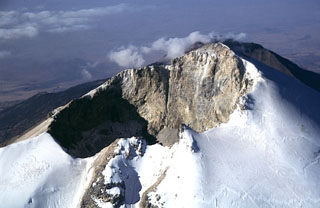 The Pico de Orizaba summit crater is 400 x 500 m with a crater floor 300 m below the summit on the NW side of the rim. Climbers' tracks can be seen on the Jamapa Glacier to the lower right.
  Pico de Orizaba (Volcán Citlaltépetl) formed on the margin of the Altiplano and has substantially higher relief on its eastern (right) side. Debris avalanches and lahars produced by edifice collapse have swept down the eastern flanks onto the coastal plain. A lava flow with lateral levees is visible on the lower SW flank below the summit. The eroded peak to the lower left beyond the lava flow terminus is Sierra Negra, the southernmost peak of the Cofre de Perote-Orizaba volcanic chain.
The maps shown below have been scanned from the GVP map archives and include the volcano on this page. Clicking on the small images will load the full 300 dpi map. Very small-scale maps (such as world maps) are not included. The maps database originated over 30 years ago, but was only recently updated and connected to our main database. We welcome users to tell us if they see incorrect information or other problems with the maps; please use the Contact GVP link at the bottom of the page to send us email.
The following 1 samples associated with this volcano can be found in the Smithsonian's NMNH Department of Mineral Sciences collections, and may be availble for research (contact the Rock and Ore Collections Manager). Catalog number links will open a window with more information.
| Catalog Number | Sample Description | Lava Source | Collection Date |
|---|---|---|---|
| NMNH 61330 | Hornblende Andesite | -- | -- |
| Copernicus Browser | The Copernicus Browser replaced the Sentinel Hub Playground browser in 2023, to provide access to Earth observation archives from the Copernicus Data Space Ecosystem, the main distribution platform for data from the EU Copernicus missions. |
| MIROVA | Middle InfraRed Observation of Volcanic Activity (MIROVA) is a near real time volcanic hot-spot detection system based on the analysis of MODIS (Moderate Resolution Imaging Spectroradiometer) data. In particular, MIROVA uses the Middle InfraRed Radiation (MIR), measured over target volcanoes, in order to detect, locate and measure the heat radiation sourced from volcanic activity. |
| MODVOLC Thermal Alerts | Using infrared satellite Moderate Resolution Imaging Spectroradiometer (MODIS) data, scientists at the Hawai'i Institute of Geophysics and Planetology, University of Hawai'i, developed an automated system called MODVOLC to map thermal hot-spots in near real time. For each MODIS image, the algorithm automatically scans each 1 km pixel within it to check for high-temperature hot-spots. When one is found the date, time, location, and intensity are recorded. MODIS looks at every square km of the Earth every 48 hours, once during the day and once during the night, and the presence of two MODIS sensors in space allows at least four hot-spot observations every two days. Each day updated global maps are compiled to display the locations of all hot spots detected in the previous 24 hours. There is a drop-down list with volcano names which allow users to 'zoom-in' and examine the distribution of hot-spots at a variety of spatial scales. |
|
WOVOdat
Single Volcano View Temporal Evolution of Unrest Side by Side Volcanoes |
WOVOdat is a database of volcanic unrest; instrumentally and visually recorded changes in seismicity, ground deformation, gas emission, and other parameters from their normal baselines. It is sponsored by the World Organization of Volcano Observatories (WOVO) and presently hosted at the Earth Observatory of Singapore.
GVMID Data on Volcano Monitoring Infrastructure The Global Volcano Monitoring Infrastructure Database GVMID, is aimed at documenting and improving capabilities of volcano monitoring from the ground and space. GVMID should provide a snapshot and baseline view of the techniques and instrumentation that are in place at various volcanoes, which can be use by volcano observatories as reference to setup new monitoring system or improving networks at a specific volcano. These data will allow identification of what monitoring gaps exist, which can be then targeted by remote sensing infrastructure and future instrument deployments. |
| Volcanic Hazard Maps | The IAVCEI Commission on Volcanic Hazards and Risk has a Volcanic Hazard Maps database designed to serve as a resource for hazard mappers (or other interested parties) to explore how common issues in hazard map development have been addressed at different volcanoes, in different countries, for different hazards, and for different intended audiences. In addition to the comprehensive, searchable Volcanic Hazard Maps Database, this website contains information about diversity of volcanic hazard maps, illustrated using examples from the database. This site is for educational purposes related to volcanic hazard maps. Hazard maps found on this website should not be used for emergency purposes. For the most recent, official hazard map for a particular volcano, please seek out the proper institutional authorities on the matter. |
| IRIS seismic stations/networks | Incorporated Research Institutions for Seismology (IRIS) Data Services map showing the location of seismic stations from all available networks (permanent or temporary) within a radius of 0.18° (about 20 km at mid-latitudes) from the given location of Pico de Orizaba. Users can customize a variety of filters and options in the left panel. Note that if there are no stations are known the map will default to show the entire world with a "No data matched request" error notice. |
| UNAVCO GPS/GNSS stations | Geodetic Data Services map from UNAVCO showing the location of GPS/GNSS stations from all available networks (permanent or temporary) within a radius of 20 km from the given location of Pico de Orizaba. Users can customize the data search based on station or network names, location, and time window. Requires Adobe Flash Player. |
| DECADE Data | The DECADE portal, still in the developmental stage, serves as an example of the proposed interoperability between The Smithsonian Institution's Global Volcanism Program, the Mapping Gas Emissions (MaGa) Database, and the EarthChem Geochemical Portal. The Deep Earth Carbon Degassing (DECADE) initiative seeks to use new and established technologies to determine accurate global fluxes of volcanic CO2 to the atmosphere, but installing CO2 monitoring networks on 20 of the world's 150 most actively degassing volcanoes. The group uses related laboratory-based studies (direct gas sampling and analysis, melt inclusions) to provide new data for direct degassing of deep earth carbon to the atmosphere. |
| Large Eruptions of Pico de Orizaba | Information about large Quaternary eruptions (VEI >= 4) is cataloged in the Large Magnitude Explosive Volcanic Eruptions (LaMEVE) database of the Volcano Global Risk Identification and Analysis Project (VOGRIPA). |
| EarthChem | EarthChem develops and maintains databases, software, and services that support the preservation, discovery, access and analysis of geochemical data, and facilitate their integration with the broad array of other available earth science parameters. EarthChem is operated by a joint team of disciplinary scientists, data scientists, data managers and information technology developers who are part of the NSF-funded data facility Integrated Earth Data Applications (IEDA). IEDA is a collaborative effort of EarthChem and the Marine Geoscience Data System (MGDS). |

