According to news articles, heavy rains caused landslides and flooding in the town of Verapaz, about 6 km NW of the summit of San Vicente, during 7-8 November. Mud and boulders swept down the flanks San Vicente, and in conjunction with flooded rivers, buried homes and cars; at least 144 people were killed and about 60 were missing.
Sources: Associated Press, Associated Press
Landslide in November 2009 after heavy rains
During 7-8 November 2009, heavy rains caused landslides and flooding in areas NE to NW of San Vicente in central El Salvador (figure 12), resulting in flooded rivers, buried homes and car, and casualties. The most recent volcanic activity consisted of lava flows that were covered by an eruption of neighboring Ilopango volcano in 260 AD. According to the USGS, previous earthquake-and rainfall-triggered landslides and lahars occurred in 1774, 1934, 1996, and 2001. In 1774, a lahar on the NE flank affected the town of San Vicente. The 1934 lahar on the N flank destroyed the town of Tepetitan, more than 6 km from the summit. In 1996, landslides and lahars on the S flank damaged the major roadway between Tecoluca (17 km NW) and Zacatecoluca (6 km SSW). On 13 February 2001, a M 6.6 earthquake caused more than 25 landslides on the N and NW flanks of the volcano that reportedly killed 39 people. However, no subsequent volcanic activity occurred from San Vicente, San Miguel, San Salvador, or Santa Ana volcanoes.
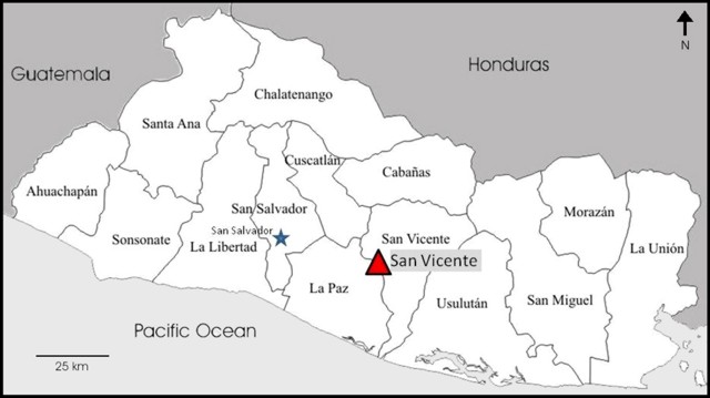 |
Figure 12. Location map of San Vicente volcano in the Departamento of San Vicente, in El Salvador. The country is divided into 14 Departamentos; five of these were affected by the 7-8 November events. The capital is San Salvador, 40 km WNW of San Vicente. |
Frequent and heavy rains on 7 November 2009 and into the next morning caused landslides, lahars, and flooding in the major drainages around the northern flanks of San Vicente. Servicio Nacional de Estudios Territoriales (SNET) reported that debris flows traveled up to 7 km away, severely affecting roads and towns. Loss of life and property were particularly severe in Verapaz, population ~ 3,000, (about 6 km NW of the summit) and Guadalupe (5 km NW from the summit, on the flanks), although damage was reported in several areas, including in the capital of San Salvador, 40 km WNW. According to the Pan American Health Organization (PAHO), the rate of rainfall at San Vicente volcano was 81 mm/hour, for a total of 355 mm in a 24-hour period. Five of the 14 Departamentos were affected by events caused by the rainfall: San Vicente, La Paz, La Libertad, San Salvador, and Cuscatlán.
On 9 November an eyewitness living in Verapaz noted in media reports that, "It was about two in the morning when the rain started coming down harder, and the earth started shaking... The next thing I knew I was lying among parts of the walls of my house." Another resident stated, "I started to hear roaring noises and the ground began to shake. Then my windows broke and lots of mud came in..." According to news articles, about 300 houses were flooded when a river in the town overflowed. Extensive damage was done to roads (figure 13), water and power sevices, and croplands in Verapaz.
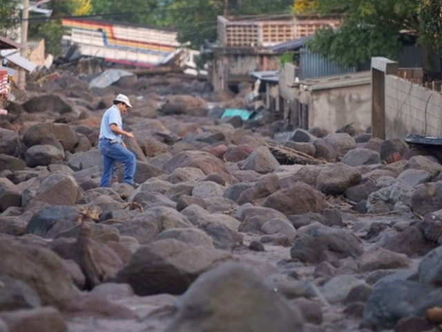 |
Figure 13. A resident walks through an area hit by a landslide after torrential rains in Verapaz, El Salvador, on 9 November 2009. Photo by Yuri Cortez, AFP/Getty Images. |
In the capital of San Salvador, eyewitnesses described an area of 8 km2 that had been covered by rocks, mud, and debris, and that many houses and hamlets had completely disappeared. At least six bridges were swept away and landslides blocked major and secondary roads, cutting communication and hindering clean-up efforts.
Based on information from PAHO, the number of people in shelters peaked on 16 November at 15,090. As of 22 November, 198 people had died, 77 were missing, and 5,759 remained in shelters. The estimated number of affected people was 75,000.
Information Contacts: Servicio Nacional de Estudios Territoriales (SNET), Km. 5 1/2 carretera a Santa Tecla y Calle las Mercedes, contiguo a Parque de Pelota, Edificio SNET, Apartado Postal 27, Centro de Gobierno, El Salvador 2283-2246 (URL: http://www.snet.gob.sv/); Pan American Health Organization (PAHO) - El Salvador, 73 Avenida Sur No. 135, Colonia Escalón, San Salvador, El Salvador (URL: http://devserver.paho.org/els/); Associated Press (URL: http://www.ap.org/); Los Angeles Times, 202 West 1st Street, Los Angeles, CA 90012, USA (URL: http://www.latimes.com/); BBC News (URL: http://news.bbc.co.uk/).
According to news articles, heavy rains caused landslides and flooding in the town of Verapaz, about 6 km NW of the summit of San Vicente, during 7-8 November. Mud and boulders swept down the flanks San Vicente, and in conjunction with flooded rivers, buried homes and cars; at least 144 people were killed and about 60 were missing.
Sources: Associated Press; Associated Press
There were reports of volcanic activity at San Vicente volcano after a M 6.6 earthquake occurred at 1422 on 13 February. The earthquake caused more than 25 landslides on the flanks of the volcano that reportedly killed 39 people. The Centro de Investigaciones Geotécnicas investigated the activity reports and determined that no volcanic activity had occurred. In addition, the government reported that there was no volcanic activity at San Miguel, San Salvador, or Santa Ana volcanoes.
Sources: Servicio Nacional de Estudios Territoriales (SNET); US Geological Survey Earthquake Hazards Program; Diario del Hoy (elsalvador.com); La Prensa Grafica; US Geological Survey Volcano Disaster Assistance Program (VDAP)
Reports are organized chronologically and indexed below by Month/Year (Publication Volume:Number), and include a one-line summary. Click on the index link or scroll down to read the reports.
Landslide in November 2009 after heavy rains
During 7-8 November 2009, heavy rains caused landslides and flooding in areas NE to NW of San Vicente in central El Salvador (figure 12), resulting in flooded rivers, buried homes and car, and casualties. The most recent volcanic activity consisted of lava flows that were covered by an eruption of neighboring Ilopango volcano in 260 AD. According to the USGS, previous earthquake-and rainfall-triggered landslides and lahars occurred in 1774, 1934, 1996, and 2001. In 1774, a lahar on the NE flank affected the town of San Vicente. The 1934 lahar on the N flank destroyed the town of Tepetitan, more than 6 km from the summit. In 1996, landslides and lahars on the S flank damaged the major roadway between Tecoluca (17 km NW) and Zacatecoluca (6 km SSW). On 13 February 2001, a M 6.6 earthquake caused more than 25 landslides on the N and NW flanks of the volcano that reportedly killed 39 people. However, no subsequent volcanic activity occurred from San Vicente, San Miguel, San Salvador, or Santa Ana volcanoes.
|
Figure 12. Location map of San Vicente volcano in the Departamento of San Vicente, in El Salvador. The country is divided into 14 Departamentos; five of these were affected by the 7-8 November events. The capital is San Salvador, 40 km WNW of San Vicente. |
Frequent and heavy rains on 7 November 2009 and into the next morning caused landslides, lahars, and flooding in the major drainages around the northern flanks of San Vicente. Servicio Nacional de Estudios Territoriales (SNET) reported that debris flows traveled up to 7 km away, severely affecting roads and towns. Loss of life and property were particularly severe in Verapaz, population ~ 3,000, (about 6 km NW of the summit) and Guadalupe (5 km NW from the summit, on the flanks), although damage was reported in several areas, including in the capital of San Salvador, 40 km WNW. According to the Pan American Health Organization (PAHO), the rate of rainfall at San Vicente volcano was 81 mm/hour, for a total of 355 mm in a 24-hour period. Five of the 14 Departamentos were affected by events caused by the rainfall: San Vicente, La Paz, La Libertad, San Salvador, and Cuscatlán.
On 9 November an eyewitness living in Verapaz noted in media reports that, "It was about two in the morning when the rain started coming down harder, and the earth started shaking... The next thing I knew I was lying among parts of the walls of my house." Another resident stated, "I started to hear roaring noises and the ground began to shake. Then my windows broke and lots of mud came in..." According to news articles, about 300 houses were flooded when a river in the town overflowed. Extensive damage was done to roads (figure 13), water and power sevices, and croplands in Verapaz.
|
Figure 13. A resident walks through an area hit by a landslide after torrential rains in Verapaz, El Salvador, on 9 November 2009. Photo by Yuri Cortez, AFP/Getty Images. |
In the capital of San Salvador, eyewitnesses described an area of 8 km2 that had been covered by rocks, mud, and debris, and that many houses and hamlets had completely disappeared. At least six bridges were swept away and landslides blocked major and secondary roads, cutting communication and hindering clean-up efforts.
Based on information from PAHO, the number of people in shelters peaked on 16 November at 15,090. As of 22 November, 198 people had died, 77 were missing, and 5,759 remained in shelters. The estimated number of affected people was 75,000.
Information Contacts: Servicio Nacional de Estudios Territoriales (SNET), Km. 5 1/2 carretera a Santa Tecla y Calle las Mercedes, contiguo a Parque de Pelota, Edificio SNET, Apartado Postal 27, Centro de Gobierno, El Salvador 2283-2246 (URL: http://www.snet.gob.sv/); Pan American Health Organization (PAHO) - El Salvador, 73 Avenida Sur No. 135, Colonia Escalón, San Salvador, El Salvador (URL: http://devserver.paho.org/els/); Associated Press (URL: http://www.ap.org/); Los Angeles Times, 202 West 1st Street, Los Angeles, CA 90012, USA (URL: http://www.latimes.com/); BBC News (URL: http://news.bbc.co.uk/).
This compilation of synonyms and subsidiary features may not be comprehensive. Features are organized into four major categories: Cones, Craters, Domes, and Thermal Features. Synonyms of features appear indented below the primary name. In some cases additional feature type, elevation, or location details are provided.
Synonyms |
||||
| Chichontepeque | Chichontepec | ||||
Cones |
||||
| Feature Name | Feature Type | Elevation | Latitude | Longitude |
| Guadalupe, Cerro de | Pyroclastic cone | 13° 37' 0" N | 88° 54' 0" W | |
| Ramírez, Cerro | Pyroclastic cone | 700 m | 13° 38' 0" N | 88° 48' 0" W |
Craters |
||||
| Feature Name | Feature Type | Elevation | Latitude | Longitude |
| Carbonera, La | Pleistocene caldera | 1300 m | 13° 38' 0" N | 88° 56' 0" W |
Domes |
||||
| Feature Name | Feature Type | Elevation | Latitude | Longitude |
| Nahuistepec | Dome | 613 m | 13° 30' 0" N | 88° 58' 0" W |
Thermal |
||||
| Feature Name | Feature Type | Elevation | Latitude | Longitude |
|
Agua Agria, Ausoles de
San Vicente, Ausoles de |
Thermal | |||
| Infiernillos Ciegos de Candelario San Vicente | Thermal | 840 m | 13° 37' 24" N | 88° 51' 6" W |
|
|
||||||||||||||||||||||||||
The Global Volcanism Program is not aware of any Holocene eruptions from San Vicente. If this volcano has had large eruptions (VEI >= 4) prior to 10,000 years ago, information might be found on the San Vicente page in the LaMEVE (Large Magnitude Explosive Volcanic Eruptions) database, a part of the Volcano Global Risk Identification and Analysis Project (VOGRIPA).
There is no Deformation History data available for San Vicente.
There is no Emissions History data available for San Vicente.
 San Vicente is seen here from the north along the Pan-American highway. Numerous hot springs and fumaroles are found on its flanks.
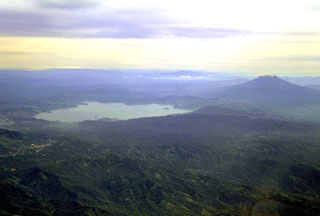 Ilopango caldera is seen in this aerial view from the SW with San Vicente stratovolcano to the right. The latest collapse of the 13 x 17 km caldera occurred after a powerful eruption during 536-550 CE that produced widespread pyroclastic flows and devastated early Mayan cities. The caldera now contains a lake with lava domes forming small islands near the shore and near its center.
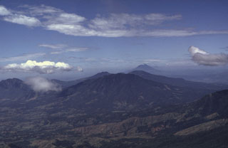 This view from the summit of San Miguel shows the E-W-trending volcanic chain between it and San Vicente volcano, the peak in the distance to the right. The flank of Chinameca in the foreground (right) and the broad El Tigre volcano is in the center. Behind El Tigre are the peaks of the Tecapa volcanic complex and to the far left is Usulután.
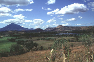 The Apastepeque volcanic field consists of a cluster of about two dozen lava domes, scoria cones, and craters NE of San Vicente volcano, the large edifice to the left. The Laguna de Apastepeque crater is to the right, below Cerro Las Delicias lava dome. Near the center of the horizon is Cerro Santa Rita lava dome.
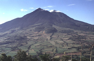 Lobate lava flows are seen on the northern flank of San Vicente. These and other flows of San Vicente were emplaced within 7 km of the summit and are overlain by pumice of the Tierra Blanca Joven (TBJ) formation, erupted from neighboring Ilopango caldera about 1,500 years ago.
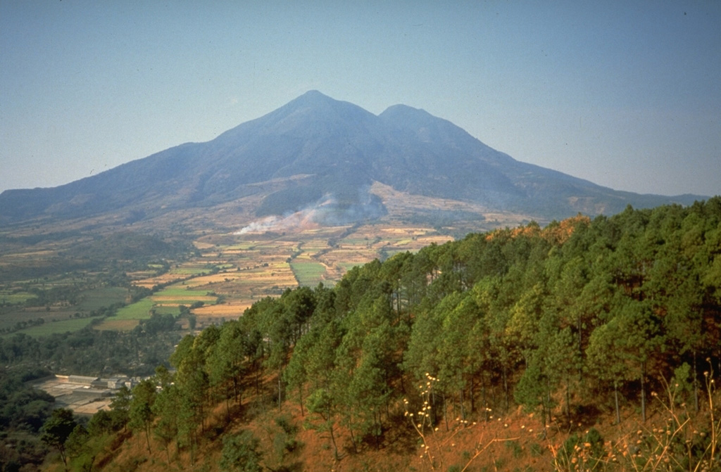
 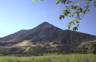 San Vicente is one of the largest volcanoes in El Salvador and is seen here from the east. The 130 km3 edifice was constructed within the Pleistocene La Carbonera caldera.
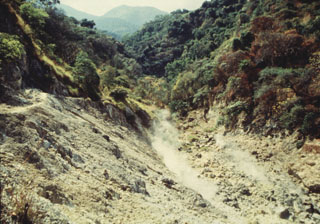 Fumaroles are seen here within Ausoles de Agua Agria, a large thermal area on the flank of San Vicente. Low-temperature fumaroles (less than 100°C) and hot springs are located along faults through the northern and western flanks.
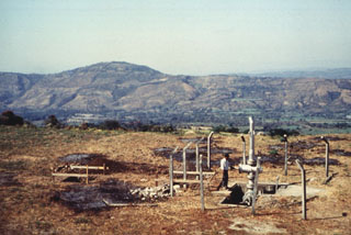 San Vicente is one of several volcanoes that have been the sites of geothermal exploration projects in El Salvador. The SV-1 well in the foreground is located on the northern flank. The low Cerro el Cerrón lava dome, part of the Apastepeque volcanic field, is to the NE on the left horizon.
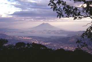 Lake Ilopango occupies the Ilopango caldera immediately east of the capital city of El Salvador, seen in the foreground. This view is from San Salvador volcano with San Vicente volcano in the background. The caldera formed during four major eruptions, the last of which was about 1,500 years ago. This eruption deposited ash and pumice over much of central and western El Salvador.
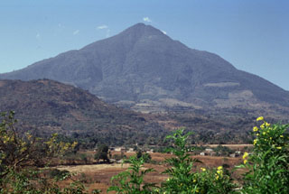 The easternmost peak of San Vicente is seen here from the NE along the road to the city of San Vicente. The hill in the foreground (left) is Cerro Ramírez, a flank cone that is one of the most recent features of the volcanic complex.
 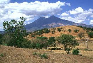 San Vicente is one of El Salvador's largest volcanoes. The hill in the foreground is a hummock of the Tecoluca debris avalanche deposit on the SE flank, with the main edifice in the background. The avalanche and associated lahars traveled about 25 km to the Río Lempa.
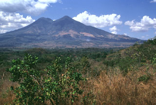 San Vicente is seen here from the SE. The modern edifice is largely constructed of thick lobate lava flows that originated primarily from summit vents and a vent on the eastern flank.
 San Vicente rises about 2 km above the Pacific coastal plain of El Salvador. The volcano has formed within the Pleistocene La Carbonera caldera and has buried the eastern caldera rim. The edifice and caldera are within the 20-30 km wide Central Graben within Tertiary volcanic basement rocks.
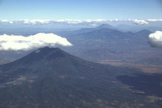 This view to the east across the main El Salvador volcanic front shows San Vicente volcano in the foreground and Tecapa, El Tigre, and Usulután volcanoes to the upper right. The small cone in the saddle between Usulután and El Tigre is Cerro Oromontique. Behind Tecapa and El Tigre is conical San Miguel, and to its right in the far distance is Conchagua volcano.
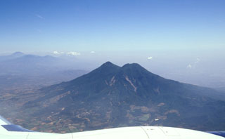 Flights from the international airport at San Salvador often pass close to San Vicente volcano, seen here from the south. The edifice is within the La Carbonera caldera, which formed during a major Plinian explosive eruption during the Pleistocene.
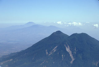 San Vicente is seen here in 2002 with landslide scarps that were produced during the January 2001 earthquake. The San Vicente area and towns at the base of the volcano were particularly affected by the tectonic earthquake and suffered extensive damage. The Tecapa volcanic complex and conical San Miguel volcano are in the distance.
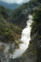 Fumaroles and sulfur deposits on the northern flank of San Vicente (or Chichontepeque) are shown in this 2011 photo. Two geothermal areas are on the N flank, located along two radial faults. These are the surface manifestations of a 12 km2 geothermal reservoir, producing thermal springs and fumaroles.
The maps shown below have been scanned from the GVP map archives and include the volcano on this page. Clicking on the small images will load the full 300 dpi map. Very small-scale maps (such as world maps) are not included. The maps database originated over 30 years ago, but was only recently updated and connected to our main database. We welcome users to tell us if they see incorrect information or other problems with the maps; please use the Contact GVP link at the bottom of the page to send us email.
There are no samples for San Vicente in the Smithsonian's NMNH Department of Mineral Sciences Rock and Ore collection.
| Copernicus Browser | The Copernicus Browser replaced the Sentinel Hub Playground browser in 2023, to provide access to Earth observation archives from the Copernicus Data Space Ecosystem, the main distribution platform for data from the EU Copernicus missions. |
| MIROVA | Middle InfraRed Observation of Volcanic Activity (MIROVA) is a near real time volcanic hot-spot detection system based on the analysis of MODIS (Moderate Resolution Imaging Spectroradiometer) data. In particular, MIROVA uses the Middle InfraRed Radiation (MIR), measured over target volcanoes, in order to detect, locate and measure the heat radiation sourced from volcanic activity. |
| MODVOLC Thermal Alerts | Using infrared satellite Moderate Resolution Imaging Spectroradiometer (MODIS) data, scientists at the Hawai'i Institute of Geophysics and Planetology, University of Hawai'i, developed an automated system called MODVOLC to map thermal hot-spots in near real time. For each MODIS image, the algorithm automatically scans each 1 km pixel within it to check for high-temperature hot-spots. When one is found the date, time, location, and intensity are recorded. MODIS looks at every square km of the Earth every 48 hours, once during the day and once during the night, and the presence of two MODIS sensors in space allows at least four hot-spot observations every two days. Each day updated global maps are compiled to display the locations of all hot spots detected in the previous 24 hours. There is a drop-down list with volcano names which allow users to 'zoom-in' and examine the distribution of hot-spots at a variety of spatial scales. |
|
WOVOdat
Single Volcano View Temporal Evolution of Unrest Side by Side Volcanoes |
WOVOdat is a database of volcanic unrest; instrumentally and visually recorded changes in seismicity, ground deformation, gas emission, and other parameters from their normal baselines. It is sponsored by the World Organization of Volcano Observatories (WOVO) and presently hosted at the Earth Observatory of Singapore.
GVMID Data on Volcano Monitoring Infrastructure The Global Volcano Monitoring Infrastructure Database GVMID, is aimed at documenting and improving capabilities of volcano monitoring from the ground and space. GVMID should provide a snapshot and baseline view of the techniques and instrumentation that are in place at various volcanoes, which can be use by volcano observatories as reference to setup new monitoring system or improving networks at a specific volcano. These data will allow identification of what monitoring gaps exist, which can be then targeted by remote sensing infrastructure and future instrument deployments. |
| Volcanic Hazard Maps | The IAVCEI Commission on Volcanic Hazards and Risk has a Volcanic Hazard Maps database designed to serve as a resource for hazard mappers (or other interested parties) to explore how common issues in hazard map development have been addressed at different volcanoes, in different countries, for different hazards, and for different intended audiences. In addition to the comprehensive, searchable Volcanic Hazard Maps Database, this website contains information about diversity of volcanic hazard maps, illustrated using examples from the database. This site is for educational purposes related to volcanic hazard maps. Hazard maps found on this website should not be used for emergency purposes. For the most recent, official hazard map for a particular volcano, please seek out the proper institutional authorities on the matter. |
| IRIS seismic stations/networks | Incorporated Research Institutions for Seismology (IRIS) Data Services map showing the location of seismic stations from all available networks (permanent or temporary) within a radius of 0.18° (about 20 km at mid-latitudes) from the given location of San Vicente. Users can customize a variety of filters and options in the left panel. Note that if there are no stations are known the map will default to show the entire world with a "No data matched request" error notice. |
| UNAVCO GPS/GNSS stations | Geodetic Data Services map from UNAVCO showing the location of GPS/GNSS stations from all available networks (permanent or temporary) within a radius of 20 km from the given location of San Vicente. Users can customize the data search based on station or network names, location, and time window. Requires Adobe Flash Player. |
| DECADE Data | The DECADE portal, still in the developmental stage, serves as an example of the proposed interoperability between The Smithsonian Institution's Global Volcanism Program, the Mapping Gas Emissions (MaGa) Database, and the EarthChem Geochemical Portal. The Deep Earth Carbon Degassing (DECADE) initiative seeks to use new and established technologies to determine accurate global fluxes of volcanic CO2 to the atmosphere, but installing CO2 monitoring networks on 20 of the world's 150 most actively degassing volcanoes. The group uses related laboratory-based studies (direct gas sampling and analysis, melt inclusions) to provide new data for direct degassing of deep earth carbon to the atmosphere. |
| Large Eruptions of San Vicente | Information about large Quaternary eruptions (VEI >= 4) is cataloged in the Large Magnitude Explosive Volcanic Eruptions (LaMEVE) database of the Volcano Global Risk Identification and Analysis Project (VOGRIPA). |
| EarthChem | EarthChem develops and maintains databases, software, and services that support the preservation, discovery, access and analysis of geochemical data, and facilitate their integration with the broad array of other available earth science parameters. EarthChem is operated by a joint team of disciplinary scientists, data scientists, data managers and information technology developers who are part of the NSF-funded data facility Integrated Earth Data Applications (IEDA). IEDA is a collaborative effort of EarthChem and the Marine Geoscience Data System (MGDS). |

