
PVMBG reported that during 1 January-18 March diffuse white plumes rose at most 200 m above Talang’s Gabuo, Utama, Selatan, and Kapundan Panjang craters. Seismicity was low, no deformation was detected, and water temperatures had not significantly changed. On 20 March the Alert Level was lowered to 1 (on a scale of 1-4). Visitors and tourists were warned to stay away from the craters.
Source: Pusat Vulkanologi dan Mitigasi Bencana Geologi (PVMBG, also known as CVGHM)
Episodes of elevated seismicity in August 2009 and February 2010
Seismicity at Talang had generally declined since February 2009. However on 16 August 2009 there was a M 6.9 earthquake centered W of Sumatra in the southern part of Siberut Island. That event caused tremors recorded at Talang. Increased seismicity through the next day led to CVGHM to raise the Alert Level for Talang from 2 to 3 (on a scale of 1-4). Monitoring was also stepped up, and an emergency response team was assigned to conduct an onsite evaluation. Foggy conditions prevented visual observations.
Between the August activity and February 2010, Talang was comparatively quiet; however in early February another episode of increased seismicity included harmonic tremor, shallow volcanic earthquakes, and deep volcanic earthquakes. By 17 February the elevated seismicity had subsided. MODVOLC satellite surveillance has shown no indications of any thermal activity.
Information Contacts: Center of Volcanology and Geological Hazard Mitigation (CVGHM), Jalan Diponegoro 57, Bandung 40122, Indonesia (URL: http://vsi.esdm.go.id/).
2015: March
2010: February
2009: August
2007: January
| March
| April
| June
| November
| December
2006: September
2005: April
| July
2001: September
| November
PVMBG reported that during 1 January-18 March diffuse white plumes rose at most 200 m above Talang’s Gabuo, Utama, Selatan, and Kapundan Panjang craters. Seismicity was low, no deformation was detected, and water temperatures had not significantly changed. On 20 March the Alert Level was lowered to 1 (on a scale of 1-4). Visitors and tourists were warned to stay away from the craters.
Source: Pusat Vulkanologi dan Mitigasi Bencana Geologi (PVMBG, also known as CVGHM)
On 17 February, CVGHM lowered the Alert Level for Talang from 3 to 2 (on a scale of 1-4) because seismicity had declined in general since February 2009. Visitors and tourists were advised not approach the crater.
Source: Pusat Vulkanologi dan Mitigasi Bencana Geologi (PVMBG, also known as CVGHM)
On 17 August, CVGHM raised the Alert Level for Talang from 2 to 3 (on a scale of 1-4) because of increased seismicity during the previous two days. Foggy conditions prevented visual observations. Visitors and tourists were advised not to go within a 3-km radius of the summit.
Source: Pusat Vulkanologi dan Mitigasi Bencana Geologi (PVMBG, also known as CVGHM)
CVGHM lowered the Alert Level at Talang to 2 (on a scale of 1-4) on 14 December based on visual observations and a decrease in the number of earthquakes. During 7-10 December, observations of the summit were limited by inclement weather. On 11 December, "smoke" rose to a maximum altitude of 3.3 km (10,800 ft) a.s.l. from the Main crater. Plumes were also observed from South crater and Gabuo Atas solfatara field. Visitors were advised not to go within a 2-km radius of the summit.
Source: Pusat Vulkanologi dan Mitigasi Bencana Geologi (PVMBG, also known as CVGHM)
CVGHM raised the Alert level for Talang from 2 to 3 (on a scale of 1-4) on 29 November based on visual observations and seismicity. Ash and steam plumes from multiple craters rose to altitudes of 3.1-4.1 km (10,200-13,500 ft) a.s.l. during 27-29 November. A strong smell of sulfur dioxide gas was also reported. Visitors and tourists were advised not to go within a 3-km radius of the summit.
Source: Pusat Vulkanologi dan Mitigasi Bencana Geologi (PVMBG, also known as CVGHM)
Based on visual observations, CVGHM reported that during 18-25 June thick brown ash plumes from Talang's Main Crater rose to an altitude of 3.1 km (10,200 ft) a.s.l. Diffuse white ash plumes rose to an altitude of about 3 km (10,000 ft) a.s.l. from the South Crater. The Alert Level remained at 2 (on a scale of 1-4).
Source: Pusat Vulkanologi dan Mitigasi Bencana Geologi (PVMBG, also known as CVGHM)
CVGHM lowered the Alert Level at Talang to 2 (on a scale of 1-4) on 27 April.
Source: Pusat Vulkanologi dan Mitigasi Bencana Geologi (PVMBG, also known as CVGHM)
Based on information from CVGHM, the Darwin VAAC reported that on 19 and 20 March ash plumes from Talang rose 3.4-3.9 km (11,000-12,800 ft) a.s.l. CVGHM raised the Alert Level to 3 (on a scale of 1-4).
Source: Darwin Volcanic Ash Advisory Centre (VAAC)
CVGHM lowered the Alert Level at Talang to 2 (on a scale of 1-4) on 27 January due to a reduction in seismic activity since 23 November 2006 to 24 January 2007. Gas plumes were present from the South Crater and the Main Crater.
Source: Pusat Vulkanologi dan Mitigasi Bencana Geologi (PVMBG, also known as CVGHM)
CVGHM raised the Alert Level at Talang to 3 (on a scale of 1-4) on 9 September due to an increase in tremor. On 10 September, a brownish plume rose 250 m above the summit (~10,000 ft a.s.l.).
Sources: Pusat Vulkanologi dan Mitigasi Bencana Geologi (PVMBG, also known as CVGHM); Washington Post
DVGHM increased the Alert Level at Talang from 2 to 3 on 18 July due to an increase in seismicity at the volcano. During 15-18 July, the seismic network recorded 93 deep volcanic earthquakes, one low-frequency tremor, and three "felt shocks" around the N slope of the crater. Minor phreatic activity occurred at the southern and northern slope craters, with ash plumes rising 0.5-1.5 km above the crater (11,100-14,400 ft a.s.l.).
Source: Pusat Vulkanologi dan Mitigasi Bencana Geologi (PVMBG, also known as CVGHM)
Small phreatic eruptions occurred at Talang on 2 and 3 July. The eruptions occurred at the main crater, and a crater on the volcano's S slope. Ash columns reached 300-500 m above the volcano (10,500-11,100 ft a.s.l.). Gabuo Atas, Gabuo Bawah, and Kapundan Panjang craters on the volcano's N slope emitted steam to low altitudes. Talang remained at Alert Level 2 (on a scale of 1-4). Visitors were not permitted to enter within a 1 km radius of the active craters.
Source: Pusat Vulkanologi dan Mitigasi Bencana Geologi (PVMBG, also known as CVGHM)
Due to a decrease in seismicity at Talang during 24-28 April, DVGHM reduced the Alert Level from 3 to 2 (on a scale of 1-4) on 28 April. Visitors were still not permitted to enter within a 1 km radius of the crater.
Source: Pusat Vulkanologi dan Mitigasi Bencana Geologi (PVMBG, also known as CVGHM)
According to DVGHM, the eruption that began at Talang on 12 April ended on 14 April. During 14-17 April, the intensity of the activity at the volcano decreased so DVGHM reduced the Alert Level from 4, the highest level, to 3. People were permitted to return their homes near the volcano, but no one could enter within 1 km of the summit.
Source: Pusat Vulkanologi dan Mitigasi Bencana Geologi (PVMBG, also known as CVGHM)
On 12 April during 0340-0600, an eruption at Talang produced an ash plume that rose to a height of ~1 km above the crater (~12,800 ft a.s.l.). About 4 mm of ash fell in the village of Bukit Sileh, NE of the volcano. The Alert Level was raised to 4, the highest level. News articles reported that thousands of residents near the volcano evacuated. Several days prior to the eruption, a "gray ash cloud" was visible rising to ~100 m above the volcano's summit (9,800 ft a.s.l.).
On 13 April volcanic and seismic activity decreased in comparison to the previous day. A "white-gray ash plume" rose 250 m (10,300 ft a.s.l.) above Kawah Mati crater, and gas was emitted from Gabuo Atas crater. There was a decrease in the number of deep volcanic, shallow volcanic, and explosion earthquakes. Talang remained at Alert Level 4.
Sources: Pusat Vulkanologi dan Mitigasi Bencana Geologi (PVMBG, also known as CVGHM); Agence France-Presse (AFP)
During 19 November- 2 December seismicity at Talang was dominated by small explosion earthquakes. In addition, there was an increase in deep volcanic earthquakes in comparison to the previous week. During 19-25 November an increase in tectonic earthquakes was recorded. Thin plumes rose ~50 m above Gabuo Atas and Kepundan Panjang fumarole fields. The volcano remained at Alert Level 2 (on a scale of 1-4).
Source: Pusat Vulkanologi dan Mitigasi Bencana Geologi (PVMBG, also known as CVGHM)
During 24-30 September volcanic activity increased at Talang volcano. Observers noted that on 25 September during 1722-1838 a thick white-brownish plume with high gas pressure rose 200-350 m above the volcano. Personnel at the observatory could smell sulfur during the evening. In comparison to measurements in 2000, temperatures increased in 2001 at Batu Bajanjang hot spring (from 40-60°C to 45-66°C), Gabuo Atas fumarole field (from 98-99°C to 111-114°C), and Gabuo Bawah fumarole field (from 96-99°C to 100-101°C). In addition, the water level at Batu Bajanjang hot spring decreased drastically. Talang was at Alert Level 2 (on a scale of 1-4).
Source: Pusat Vulkanologi dan Mitigasi Bencana Geologi (PVMBG, also known as CVGHM)
Reports are organized chronologically and indexed below by Month/Year (Publication Volume:Number), and include a one-line summary. Click on the index link or scroll down to read the reports.
Thermal field grows; steaming increases
Signs of enhanced activity at Gabuo Atas solfatara field were observed in May, when increased fuming was noted. The area of thermal activity has grown to cover ~10 hectares, but the temperatures of solfataras have remained in the normal range, between 92 and 97°C.
Information Contacts: L. Pardyanto, Olas, Kaswanda, A. Sudradjat, and T. Casadevall, VSI.
Dark fume accompanies increased thermal activity
Increased thermal activity in the Gabuo Atas solfatara field continued through July, when dark-colored fume was noted. The temperatures of the solfataras have remained in their normal range, 92-97°C.
Information Contacts: L. Pardyanto, Olas, Kaswanda, Suratman, A. Sudradjat, and T. Casadevall, VSI.
Minor steam explosions
[Minor steam explosions on 16 July and 13 October ejected a plume to 150 and 200 m above Pajang Crater.]
Information Contacts: W. Modjo and Tulus, VSI (as reported in BVE, no. 26, March 1989).
Increase in volcanic and seismic activity during 24-30 September 2001
The last reported activity at Talang occurred in October 1986 (minor steam explosions). Talang was relatively quiet after that, until September 2001, when the Volcanological Survey of Indonesia (VSI) reported an increase in activity. On 25 September 2001 the volcano ejected a "white thick-brownish" plume that rose 200-350 m. That evening, a sulfur smell was noticed at the post observatory. Temperatures at Batu Bajanjang hot spring and the fumarole fields at Gabuo Atas and Gabuo Bawah increased (table 1). The water level at Batu Bajanjang decreased drastically.
Table 1. Comparison of temperatures of various locations at Talang during 2000 and 2001. Courtesy of VSI.
| Location | 2000 Temperature | 2001 Temperature |
| Hot Spring | 40-60°C | 45-66°C |
| Gabuo Atas field | 98-99°C | 111-114°C |
| Gabuo Bawah field | 96-99°C | 100-101°C |
Because of a broken seismograph, seismicity at Talang could not be observed until 3 October. During 1-7 October, Talang was dominated by tectonic earthquakes. A thin-white plume reached 50-100 m above the summit. VSI reported four deep volcanic (A-type) events, two shallow volcanic (B-type) events, and 18 tectonic earthquakes. Talang volcano is at Alert Level 2 (on a scale of 1-4).
Information Contacts: Dali Ahmad, Volcanological Survey of Indonesia (VSI), Jalan Diponegoro No.57, Bandung 40122, Indonesia (URL: http://www.vsi.esdm.go.id/).
Small explosion earthquakes, plumes 400 m above summit during late 2001-early 2002
From late October 2001 through at least 10 March 2002 at Talang, seismicity was often dominated by small explosion earthquakes (table 2). Plumes reached up to 400 m above the summit, and the temperature at Batu Bajangjang hot spring, located ~5 km N of the summit, was reported at 43-71°C (table 3). The Alert Level remained at 2 through at least 10 March 2002.
Table 2. Earthquakes, tremor, and other seismic signals at Talang during 8 October 2001 through 10 March 2002. The seismograph was broken during 30 December through 20 January, so seismic information was not reported for that period. Courtesy VSI.
| Date | Deep volcanic (A-type) | Shallow volcanic (B-type) | Tectonic | Small explosion | Tremor |
| 08 Oct-14 Oct 2001 | 11 | -- | 17 | -- | -- |
| 15 Oct-21 Oct 2001 | 15 | 1 | 1 | -- | -- |
| 22 Oct-28 Oct 2001 | 18 | 4 | 35 | continuous | -- |
| 29 Oct-04 Nov 2001 | 14 | -- | 19 | continuous | -- |
| 05 Nov-11 Nov 2001 | 14 | 5 | 14 | 124 | 29 |
| 12 Nov-18 Nov 2001 | 8 | -- | 9 | continuous | 22 |
| 19 Nov-25 Nov 2001 | 10 | -- | 16 | 233 | 3 |
| 26 Nov-02 Dec 2001 | 14 | -- | 17 | 350 | 4 |
| 03 Dec-09 Dec 2001 | 11 | 1 | 31 | 455 | 2 |
| 17 Dec-30 Dec 2001 | 33 | 3 | 55 | -- | -- |
| 04 Feb-10 Feb 2002 | 9 | -- | 6 | 247 | 40 |
| 11 Feb-17 Feb 2002 | -- | -- | 2 | 265 | -- |
| 18 Feb-24 Feb 2002 | -- | -- | 1 | 154 | -- |
| 25 Feb-03 Mar 2002 | 3 | -- | 12 | 156 | -- |
| 03 Mar-10 Mar 2002 | 3 | 3 | 8 | 75 | -- |
Table 3. Plume details at Talang and reported temperatures at Batu Bajangjang hot spring during 8 October 2001 through 10 March 2002. Courtesy VSI.
| Date | Plume details (heights are above the summit) | Temperature at Batu Bajangjang hot spring |
| 08 Oct-14 Oct 2001 | White-thin, low-pressure plume to ~ 50-100 m. | 45-68°C |
| 15 Oct-28 Oct 2001 | White-thin, low pressure plume to ~ 50-100 m; on 15 Oct a white-brown high-pressure plume from Kepundan Panjang and Gabuo Atas solfatara/fumarole fields rose 150-200 m; on 22 October a white-thick brown plume rose 250 m from upper Kepundan Kabuo; on 24 October a brownish-gray, high-pressure plume reached 400 m. | -- |
| 29 Oct-04 Nov 2001 | White-gray thin plume from Gabuo Atas solfatara/fumarole field and from Kepundan Panjang rose 150 m. | 47-71°C |
| 05 Nov-11 Nov 2001 | White-thick plume from Gabuo Atas and Kepundan Panjang solfatara/fumarole field rose ~250-300 m and drifted S; at 2240 m elevation between Gabuo Atas and Sapan hot spring (NE of Kepundan Panjang) a whitish-brown thin medium-pressure plume rose ~200 m. | -- |
| 12 Nov-18 Nov 2001 | White-thick brownish plume from Gabuo Atas and Kepundan Panjang solfatara/fumarole fields reached 50 m and drifted S. | -- |
| 19 Nov-02 Dec 2001 | White-thin plume from Gabuo Atas and Kepundan Panjang solfatara/fumarole fields reached 50 m and drifted E. | -- |
| 03 Dec-09 Dec 2001 | White-thin plume from Gabuo Atas and Kepundan Panjang solfatara/fumarole fields rose ~50-150 m and drifted E. | 43°C |
| 17 Dec-30 Dec 2001 | White-thin, low-pressure plume rose ~50 m and drifted E. | -- |
| 30 Dec-20 Jan 2002 | White-thin plume rose 50-100 m. | 43-64°C |
| 04 Feb-10 Mar 2002 | White-thin plume rose 100-150 m. | -- |
Information Contacts: Dali Ahmad, Volcanological Survey of Indonesia (VSI), Jalan Diponegoro No. 57, Bandung 40122, Indonesia (URL: http://www.vsi.esdm.go.id/).
Small explosion earthquakes dominate through June 2002
During 11 March-16 June 2002 at Talang, seismicity was dominated by small explosion earthquakes (table 4). A thin white plume reached 50-100 m above the summit and sometimes drifted E. Hotspring temperatures were 42-64°C. As of 13 May, the Volcanological Survey of Indonesia (VSI) reported that no seismic data were available because of a broken seismograph. During April and early May seismicity had been decreasing. Talang remained at Alert Level 2 (on a scale of 1-4) throughout the report period.
Table 4. Earthquakes at Talang during 11 March-12 May 2002. The seismograph was broken as of 13 May, so no seismicity data was available through at least 16 June. Courtesy VSI.
| Date | Deep volcanic (A-type) | Shallow volcanic (B-type) | Small explosion | Tectonic |
| 11 Mar-17 Mar 2002 | 1 | 17 | 61 | 14 |
| 18 Mar-24 Mar 2002 | 2 | -- | 120 | 9 |
| 25 Mar-31 Mar 2002 | 2 | -- | 120 | 13 |
| 01 Apr-07 Apr 2002 | 2 | -- | 63 | 5 |
| 08 Apr-14 Apr 2002 | 1 | -- | 23 | 12 |
| 15 Apr-21 Apr 2002 | 3 | -- | -- | 6 |
| 22 Apr-28 Apr 2002 | 6 | -- | -- | 7 |
| 29 Apr-05 May 2002 | 4 | -- | -- | 14 |
| 06 May-12 May 2002 | 3 | -- | -- | 3 |
Information Contacts: Volcanological Survey of Indonesia (VSI), Jalan Diponegoro No. 57, Bandung 40122, Indonesia (URL: http://www.vsi.esdm.go.id/).
Plume reached up to 100 m above the crater during July 2002
During 17 June-28 July 2002 at Talang a generally white, thin plume rose 25-100 m above the crater and drifted E. [Throughout July the activity was described as a "white-thin ash plume."] Hot spring temperatures ranged from 43 to 64°C. No seismic data were available because of a broken seismograph. Talang remained at Alert Level 2.
Information Contacts: Volcanological Survey of Indonesia (VSI), Jalan Diponegoro No. 57, Bandung 40122, Indonesia (URL: http://www.vsi.esdm.go.id/).
Short eruptive episode in April 2005; elevated activity in late 2006
Indonesian volcanologists with the Center of Volcanology and Geological Hazard Mitigation (CVGHM) (previously known by other names, including the Volcanological Survey of Indonesia) maintain an observation post and seismic network at Talang. After intermittent activity during September 2001 (BGVN 26:10) until June 2002 (BGVN 27:06), there was no additional reported activity until 2005 and 2006.
Activity during April 2005. On 12 April 2005 an eruption at Talang during 0340-0600 produced an ash plume that rose to ~ 1 km above the crater. About 4 mm of ash fell in the village of Bukit Sileh, NE of the crater. On the afternoon of 10 April observers had noted a "grey ash cloud" rising ~ 100 m, followed the next day by a diffuse white cloud around the summit. Volcanologist Dalipa, who heads the Batu Bajanjang observation post, told The Jakarta Post that there had been five large eruptions and hundreds of small eruptions before 1200 on 12 April that caused ashfall as far as 10 km away. He added that between the evening of 12 April and 0600 the next morning there were only six small eruptions.
An infrared image (GOES-9) taken at 0425 on 12 April 2005, analyzed by the Darwin VAAC, showed the eruption plume. There was a weak ash signature in the small cloud for a couple of hours before it became difficult to track. Plume height was estimated to be 7.5 km because the upper part of the cloud went NW, and winds below that were more or less westerly. The height of the cloud would have been difficult to see from the ground during the peak activity before dawn.
Simon Carn reported that the Ozone Monitoring Instrument (OMI) on EOS/Aura detected an SO2 plume from Talang on 12 April at 1402, and possible much weaker emissions on 13 April. The plume on 12 April extended roughly ESE towards central Sumatra, so was presumably at a lower elevation than the upper part of the ash cloud imaged earlier by the Darwin VAAC. The preliminary estimated SO2 mass was around 1,000 metric tons. Weak emissions were reported several days prior to the 12 April event, but OMI data only showed SO2 emissions from nearby Kerinci volcano.
A local government official told news media on 14 April that 25,150 residents from five villages in Lembang Jaya and Gunung Talang districts, located within a 5-km radius from the danger zone, had been evacuated. Winds were reportedly carrying ash downslope along with volcanic gases.
On 13 April volcanic and seismic activity decreased in comparison to the previous day. A "white-gray ash plume" rose 250 m from three points inside Kawah Mati crater, and white gas was emitted from Gabuo Atas crater. There was a decrease in the number of deep volcanic, shallow volcanic, and explosion earthquakes. By 0600 on 14 April the only reported activity was a diffuse "white ash" plume rising 250-300 m above the crater. However, news media quoting a government geologist reported that Talang "sent out fresh clouds of dust and continued to rumble" on 15 April.
By 17 April, activity had decreased and volcanologists lowered the hazard status to 3 (on a scale of 1-4). People were permitted to return their homes near the volcano, but no one could enter within 1 km of the summit. Due to a continued decrease in seismicity during 24-28 April (less than 10 volcanic events per day), the Alert Level was dropped to 2 on 28 April. Due to the hazards of minor phreatic eruptions, unstable land, and toxic gases, the area within a 1-km radius of the crater remained closed.
Activity during July 2005. Small phreatic eruptions occurred on 2 and 3 July 2005. The eruptions occurred at the main crater and a crater on the S slope. Ash columns reached 300-500 m above the volcano and caused 0.5-1 mm of ashfall around Kampung Batu, 2 km S of the summit. On the N slope, the Gabuo Atas, Gabuo Bawah, and Kapundan Panjang craters emitted "white-brown steam" to low altitudes. The temperature of Batu Bajanjang hotspring, located below the summit, was 41.9-61.3°C. The hazard status remained unchanged at Alert level 2 (on a scale of 1-4).
Increased seismicity on 18 July prompted an change in the Alert Level to 3. During 15-18 July, the seismic network recorded 93 deep volcanic earthquakes, one low-frequency tremor, and three "felt shocks" around the N slope of the crater. Minor phreatic activity occurred at the S and N slope craters, with dark gray ash plumes rising 0.5-1.5 km above the crater on 18 July.
Activity during September 2006. Increasing seismicity and gas emissions led to the hazard status being raised to Alert Level 3 on 9 September 2006. The next day "brownish smoke" was being emitted to heights of 250 m. The daily number of volcanic earthquakes and tremor fluctuated over the next few months, reaching a high of 33 events on 23 November. After that date seismicity showed a decreasing trend through late January 2007. Weak gas emissions continued during this period from both South Crater and Main Crater. Due to the lowered levels of activity, the hazards status was once again dropped to Alert Level 2 on 27 January.
Information Contacts: Center of Volcanology and Geological Hazard Mitigation, Diponegoro 57, Bandung, Jawa Barat 40122, Indonesia (URL: http://vsi.esdm.go.id/); Andrew Tupper, Darwin Volcanic Ash Advisory Centre, Bureau of Meteorology, Australia (URL: http://www.bom.gov.au/info/vaac/); Simon Carn, Joint Center for Earth Systems Technology (JCET), University of Maryland Baltimore County (UMBC), 1000 Hilltop Circle, Baltimore, MD 21250, USA; Agence France-Presse (AFP) (URL: http://www.afp.com/english/home/); Indahnesia.com (URL: http://news.indahnesia.com/); The Jakarta Post, Indonesia (URL: http://www.thejakartapost.com/); Associated Press (URL: http://www.ap.org/).
Ash emissions in March, June, and November 2007
The Center of Volcanology and Geological Hazard Mitigation (CVGHM) lowered the Alert Level of Talang to 2 (on a scale of 1-4) on 27 January 2007 due to a reduced seismicity between 23 November 2006 and 24 January 2007, although gas plumes originated from South and Main craters. There had been eruptive episodes in April 2005 and elevated activity during late 2006 (BGVN 32:01).
On 17 March 2007, CVGHM raised the Alert Level based on increased "smoke" and tremors to 3 (on a scale of 1-4). The Darwin Volcanic Ash Advisory Centre (VAAC) reported that, based on information from CVGHM, ash plumes rose to altitudes of 3.4-3.9 km on 19-20 March. Local authorities and residents were advised to prepare for a possible evacuation. On 23 April 2007 the Alert Level was reduced to 2. During 18-25 June, thick brown ash plumes rose from Main crater to an altitude of 3.1 km. Diffuse "white ash" plumes rose from South crater to an altitude of 3 km.
On 29 November CVGHM raised the Alert Level to 3 (on a scale of 1-4) based on visual observations and seismicity. During 27-29 November, ash and steam plumes from multiple craters rose to altitudes of 3.1-4.1 km. A strong smell of sulfur dioxide gas was reported. Visitors were advised not to go within 3 km of the summit.
During 7-10 December, observations were limited by inclement weather. On 11 December, "smoke" rose from the Main crater to a maximum altitude of 3.3 km. Plumes were also observed from the South crater and Gabuo Atas solfatara field. On 14 December visual observations and a decrease in the number of earthquakes prompted a lowering of the Alert Level back to 2.
Information Contacts: Darwin Volcanic Ash Advisory Centre, Bureau of Meteorology, Commonwealth of Australia (URL: http://www.bom.gov.au/info/vaac); Center of Volcanology and Geological Hazard Mitigation (CVGHM), Jalan Diponegoro 57, Bandung 40122, Indonesia (URL: http://www.vsi.esdm.go.id/).
Sudden occurrence of over 900 earthquakes on 16-17 August 2009
Talang had an increase in seismicity during mid-2009. Minor tremor and emissions of ash and sulfur dioxide (SO2) occurred during 2007 (BGVN 33:02). The Alert Level was lowered to 2 (on a scale of 1-4) on 14 December 2007 based on visual observations and a decrease in earthquakes.
In their report of 17 August the Center of Volcanology and Geological Hazard Mitigation (CVGHM) reported seismic activity between 1430 on 16 August through 0600 on 17 August. On 15 August there were four deep volcanic events and one low-frequency earthquake. Over the next two days they recorded 917 deep volcanic and another 30 shallow volcanic earthquakes, along with continuous tremor. Because of the significant increase in seismic activity, CVGHM increased the Alert Level from 2 to 3. It also stepped up its monitoring and assigned an emergency response team to conduct an onsite evaluation. Foggy conditions prevented visual observations. Visitors and tourists were advised not to go within 3-km of the summit.
Information Contacts: Center of Volcanology and Geological Hazard Mitigation (CVGHM), Jalan Diponegoro 57, Bandung 40122, Indonesia (URL: http://vsi.esdm.go.id/).
Episodes of elevated seismicity in August 2009 and February 2010
Seismicity at Talang had generally declined since February 2009. However on 16 August 2009 there was a M 6.9 earthquake centered W of Sumatra in the southern part of Siberut Island. That event caused tremors recorded at Talang. Increased seismicity through the next day led to CVGHM to raise the Alert Level for Talang from 2 to 3 (on a scale of 1-4). Monitoring was also stepped up, and an emergency response team was assigned to conduct an onsite evaluation. Foggy conditions prevented visual observations.
Between the August activity and February 2010, Talang was comparatively quiet; however in early February another episode of increased seismicity included harmonic tremor, shallow volcanic earthquakes, and deep volcanic earthquakes. By 17 February the elevated seismicity had subsided. MODVOLC satellite surveillance has shown no indications of any thermal activity.
Information Contacts: Center of Volcanology and Geological Hazard Mitigation (CVGHM), Jalan Diponegoro 57, Bandung 40122, Indonesia (URL: http://vsi.esdm.go.id/).
This compilation of synonyms and subsidiary features may not be comprehensive. Features are organized into four major categories: Cones, Craters, Domes, and Thermal Features. Synonyms of features appear indented below the primary name. In some cases additional feature type, elevation, or location details are provided.
Synonyms |
||||
| Tallang | Salasi | Soelasih | ||||
Cones |
||||
| Feature Name | Feature Type | Elevation | Latitude | Longitude |
| Pasar Arbaa | Stratovolcano | 2472 m | 0° 58' 48" S | 100° 40' 1" E |
|
|
||||||||||||||||||||||||
There is data available for 13 confirmed Holocene eruptive periods.
2007 Nov 27 - 2007 Dec 16 (?) ± 15 days Confirmed Eruption Max VEI: 2
| Episode 1 | Eruption Episode | |||||||||||||||||||||||||
|---|---|---|---|---|---|---|---|---|---|---|---|---|---|---|---|---|---|---|---|---|---|---|---|---|---|
| 2007 Nov 27 - 2007 Dec 16 (?) ± 15 days | Evidence from Observations: Reported | ||||||||||||||||||||||||
|
List of 3 Events for Episode 1
| |||||||||||||||||||||||||
2007 Mar 19 - 2007 Jun 22 ± 3 days Confirmed Eruption Max VEI: 2
| Episode 1 | Eruption Episode | Main crater | ||||||||||||||||||||||||||||||||||
|---|---|---|---|---|---|---|---|---|---|---|---|---|---|---|---|---|---|---|---|---|---|---|---|---|---|---|---|---|---|---|---|---|---|---|---|
| 2007 Mar 19 - 2007 Jun 22 ± 3 days | Evidence from Observations: Reported | ||||||||||||||||||||||||||||||||||
|
List of 5 Events for Episode 1 at Main crater
| |||||||||||||||||||||||||||||||||||
2006 Sep 10 - 2006 Sep 10 Confirmed Eruption Max VEI: 1
| Episode 1 | Eruption Episode | ||||||||||||||||||||||||||||||
|---|---|---|---|---|---|---|---|---|---|---|---|---|---|---|---|---|---|---|---|---|---|---|---|---|---|---|---|---|---|---|
| 2006 Sep 10 - 2006 Sep 10 | Evidence from Observations: Reported | |||||||||||||||||||||||||||||
|
List of 4 Events for Episode 1
| ||||||||||||||||||||||||||||||
2005 Apr 12 (?) - 2005 Jul 18 (?) Confirmed Eruption Max VEI: 2
| Episode 1 | Eruption Episode | North & south flanks | |||||||||||||||||||||||||||||||||||||||
|---|---|---|---|---|---|---|---|---|---|---|---|---|---|---|---|---|---|---|---|---|---|---|---|---|---|---|---|---|---|---|---|---|---|---|---|---|---|---|---|---|
| 2005 Apr 12 (?) - 2005 Jul 18 (?) | Evidence from Observations: Reported | |||||||||||||||||||||||||||||||||||||||
|
List of 6 Events for Episode 1 at North & south flanks
| ||||||||||||||||||||||||||||||||||||||||
2001 Sep 25 - 2001 Nov 15 ± 3 days Confirmed Eruption Max VEI: 1
| Episode 1 | Eruption Episode | Kepundan Panjang & Kabuo, Gabuo Atas | ||||||||||||||||||||||||
|---|---|---|---|---|---|---|---|---|---|---|---|---|---|---|---|---|---|---|---|---|---|---|---|---|---|
| 2001 Sep 25 - 2001 Nov 15 ± 3 days | Evidence from Observations: Reported | ||||||||||||||||||||||||
|
List of 3 Events for Episode 1 at Kepundan Panjang & Kabuo, Gabuo Atas
| |||||||||||||||||||||||||
[ 1986 Jul 16 - 1986 Oct 13 ] Uncertain Eruption
| Episode 1 | Eruption Episode | NE flank (Panjang Crater) | |||||||||||||||||||
|---|---|---|---|---|---|---|---|---|---|---|---|---|---|---|---|---|---|---|---|---|
| 1986 Jul 16 - 1986 Oct 13 | Evidence from Unknown | |||||||||||||||||||
|
List of 2 Events for Episode 1 at NE flank (Panjang Crater)
| ||||||||||||||||||||
1968 Sep 16 ± 15 days - 1968 Oct 16 ± 15 days Confirmed Eruption Max VEI: 2
| Episode 1 | Eruption Episode | NE flank | ||||||||||||||||||||||||
|---|---|---|---|---|---|---|---|---|---|---|---|---|---|---|---|---|---|---|---|---|---|---|---|---|---|
| 1968 Sep 16 ± 15 days - 1968 Oct 16 ± 15 days | Evidence from Observations: Reported | ||||||||||||||||||||||||
|
List of 3 Events for Episode 1 at NE flank
| |||||||||||||||||||||||||
1968 Jan 14 - 1968 Jan 14 (?) Confirmed Eruption Max VEI: 1
| Episode 1 | Eruption Episode | NE flank | ||||||||||||||||||||||||
|---|---|---|---|---|---|---|---|---|---|---|---|---|---|---|---|---|---|---|---|---|---|---|---|---|---|
| 1968 Jan 14 - 1968 Jan 14 (?) | Evidence from Observations: Reported | ||||||||||||||||||||||||
|
List of 3 Events for Episode 1 at NE flank
| |||||||||||||||||||||||||
1967 Oct 10 - 1967 Oct 10 Confirmed Eruption Max VEI: 1
| Episode 1 | Eruption Episode | NE flank (200 m below summit) | ||||||||||||||||||||||||
|---|---|---|---|---|---|---|---|---|---|---|---|---|---|---|---|---|---|---|---|---|---|---|---|---|---|
| 1967 Oct 10 - 1967 Oct 10 | Evidence from Observations: Reported | ||||||||||||||||||||||||
|
List of 3 Events for Episode 1 at NE flank (200 m below summit)
| |||||||||||||||||||||||||
1963 Jul 2 ± 182 days Confirmed Eruption Max VEI: 2
| Episode 1 | Eruption Episode | |||||||||||||||
|---|---|---|---|---|---|---|---|---|---|---|---|---|---|---|---|
| 1963 Jul 2 ± 182 days - Unknown | Evidence from Observations: Reported | ||||||||||||||
|
List of 1 Events for Episode 1
| |||||||||||||||
1876 (?) Confirmed Eruption Max VEI: 2
| Episode 1 | Eruption Episode | NE flank | |||||||||||||||||||
|---|---|---|---|---|---|---|---|---|---|---|---|---|---|---|---|---|---|---|---|---|
| 1876 (?) - Unknown | Evidence from Observations: Reported | |||||||||||||||||||
|
List of 2 Events for Episode 1 at NE flank
| ||||||||||||||||||||
[ 1868 ± 3 years ] Uncertain Eruption
| Episode 1 | Eruption Episode | |||||||||||||||
|---|---|---|---|---|---|---|---|---|---|---|---|---|---|---|---|
| 1868 ± 3 years - Unknown | Evidence from Unknown | ||||||||||||||
|
List of 1 Events for Episode 1
| |||||||||||||||
1845 Apr 22 Confirmed Eruption Max VEI: 2
| Episode 1 | Eruption Episode | NE flank | |||||||||||||||||||
|---|---|---|---|---|---|---|---|---|---|---|---|---|---|---|---|---|---|---|---|---|
| 1845 Apr 22 - Unknown | Evidence from Observations: Reported | |||||||||||||||||||
|
List of 2 Events for Episode 1 at NE flank
| ||||||||||||||||||||
1843 Oct 21 Confirmed Eruption Max VEI: 2
| Episode 1 | Eruption Episode | NE flank (some reports list 1842 date) | |||||||||||||||||||
|---|---|---|---|---|---|---|---|---|---|---|---|---|---|---|---|---|---|---|---|---|
| 1843 Oct 21 - Unknown | Evidence from Observations: Reported | |||||||||||||||||||
|
List of 2 Events for Episode 1 at NE flank (some reports list 1842 date)
| ||||||||||||||||||||
1833 Oct Confirmed Eruption Max VEI: 2
| Episode 1 | Eruption Episode | NE flank | |||||||||||||||||||
|---|---|---|---|---|---|---|---|---|---|---|---|---|---|---|---|---|---|---|---|---|
| 1833 Oct - Unknown | Evidence from Observations: Reported | |||||||||||||||||||
|
List of 2 Events for Episode 1 at NE flank
| ||||||||||||||||||||
There is no Deformation History data available for Talang.
There is data available for 1 emission periods. Expand each entry for additional details.
| Start Date: 2005 Apr 12 | Stop Date: 2005 Apr 12 | Method: Satellite (Aura OMI) |
| SO2 Altitude Min: 8 km | SO2 Altitude Max: 8 km | Total SO2 Mass: 1 kt |
Data Details
| Date Start | Date End | Assumed SO2 Altitude | SO2 Algorithm | SO2 Mass |
| 20050412 | 8.0 | 1.000 |
 Talang volcano, seen here from the Volcanological Survey of Indonesia observation post at Batu Barjangan on the NNE side, is located next to the older Pasar Arbaa volcano. Historical eruptions have originated from a valley on the NE flank and have consisted of mild explosive activity.
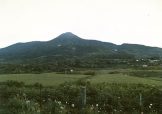
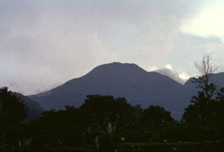 The summit of forested Gunung Talang volcano is seen here from the NW. Two crater lakes are on the flanks of the volcano and several flank eruptions took place during the 19th century.
The maps shown below have been scanned from the GVP map archives and include the volcano on this page. Clicking on the small images will load the full 300 dpi map. Very small-scale maps (such as world maps) are not included. The maps database originated over 30 years ago, but was only recently updated and connected to our main database. We welcome users to tell us if they see incorrect information or other problems with the maps; please use the Contact GVP link at the bottom of the page to send us email.
There are no samples for Talang in the Smithsonian's NMNH Department of Mineral Sciences Rock and Ore collection.
| Copernicus Browser | The Copernicus Browser replaced the Sentinel Hub Playground browser in 2023, to provide access to Earth observation archives from the Copernicus Data Space Ecosystem, the main distribution platform for data from the EU Copernicus missions. |
| MIROVA | Middle InfraRed Observation of Volcanic Activity (MIROVA) is a near real time volcanic hot-spot detection system based on the analysis of MODIS (Moderate Resolution Imaging Spectroradiometer) data. In particular, MIROVA uses the Middle InfraRed Radiation (MIR), measured over target volcanoes, in order to detect, locate and measure the heat radiation sourced from volcanic activity. |
| MODVOLC Thermal Alerts | Using infrared satellite Moderate Resolution Imaging Spectroradiometer (MODIS) data, scientists at the Hawai'i Institute of Geophysics and Planetology, University of Hawai'i, developed an automated system called MODVOLC to map thermal hot-spots in near real time. For each MODIS image, the algorithm automatically scans each 1 km pixel within it to check for high-temperature hot-spots. When one is found the date, time, location, and intensity are recorded. MODIS looks at every square km of the Earth every 48 hours, once during the day and once during the night, and the presence of two MODIS sensors in space allows at least four hot-spot observations every two days. Each day updated global maps are compiled to display the locations of all hot spots detected in the previous 24 hours. There is a drop-down list with volcano names which allow users to 'zoom-in' and examine the distribution of hot-spots at a variety of spatial scales. |
|
WOVOdat
Single Volcano View Temporal Evolution of Unrest Side by Side Volcanoes |
WOVOdat is a database of volcanic unrest; instrumentally and visually recorded changes in seismicity, ground deformation, gas emission, and other parameters from their normal baselines. It is sponsored by the World Organization of Volcano Observatories (WOVO) and presently hosted at the Earth Observatory of Singapore.
GVMID Data on Volcano Monitoring Infrastructure The Global Volcano Monitoring Infrastructure Database GVMID, is aimed at documenting and improving capabilities of volcano monitoring from the ground and space. GVMID should provide a snapshot and baseline view of the techniques and instrumentation that are in place at various volcanoes, which can be use by volcano observatories as reference to setup new monitoring system or improving networks at a specific volcano. These data will allow identification of what monitoring gaps exist, which can be then targeted by remote sensing infrastructure and future instrument deployments. |
| Volcanic Hazard Maps | The IAVCEI Commission on Volcanic Hazards and Risk has a Volcanic Hazard Maps database designed to serve as a resource for hazard mappers (or other interested parties) to explore how common issues in hazard map development have been addressed at different volcanoes, in different countries, for different hazards, and for different intended audiences. In addition to the comprehensive, searchable Volcanic Hazard Maps Database, this website contains information about diversity of volcanic hazard maps, illustrated using examples from the database. This site is for educational purposes related to volcanic hazard maps. Hazard maps found on this website should not be used for emergency purposes. For the most recent, official hazard map for a particular volcano, please seek out the proper institutional authorities on the matter. |
| IRIS seismic stations/networks | Incorporated Research Institutions for Seismology (IRIS) Data Services map showing the location of seismic stations from all available networks (permanent or temporary) within a radius of 0.18° (about 20 km at mid-latitudes) from the given location of Talang. Users can customize a variety of filters and options in the left panel. Note that if there are no stations are known the map will default to show the entire world with a "No data matched request" error notice. |
| UNAVCO GPS/GNSS stations | Geodetic Data Services map from UNAVCO showing the location of GPS/GNSS stations from all available networks (permanent or temporary) within a radius of 20 km from the given location of Talang. Users can customize the data search based on station or network names, location, and time window. Requires Adobe Flash Player. |
| DECADE Data | The DECADE portal, still in the developmental stage, serves as an example of the proposed interoperability between The Smithsonian Institution's Global Volcanism Program, the Mapping Gas Emissions (MaGa) Database, and the EarthChem Geochemical Portal. The Deep Earth Carbon Degassing (DECADE) initiative seeks to use new and established technologies to determine accurate global fluxes of volcanic CO2 to the atmosphere, but installing CO2 monitoring networks on 20 of the world's 150 most actively degassing volcanoes. The group uses related laboratory-based studies (direct gas sampling and analysis, melt inclusions) to provide new data for direct degassing of deep earth carbon to the atmosphere. |
| Large Eruptions of Talang | Information about large Quaternary eruptions (VEI >= 4) is cataloged in the Large Magnitude Explosive Volcanic Eruptions (LaMEVE) database of the Volcano Global Risk Identification and Analysis Project (VOGRIPA). |
| EarthChem | EarthChem develops and maintains databases, software, and services that support the preservation, discovery, access and analysis of geochemical data, and facilitate their integration with the broad array of other available earth science parameters. EarthChem is operated by a joint team of disciplinary scientists, data scientists, data managers and information technology developers who are part of the NSF-funded data facility Integrated Earth Data Applications (IEDA). IEDA is a collaborative effort of EarthChem and the Marine Geoscience Data System (MGDS). |

