
Although Alaid was not erupting, KVERT issued a Volcano Observatory Notice for Aviation (VONA) at 0307 on 16 August raising the Aviation Color Code to Orange (the second highest level on a four-color scale) to warn pilots of ash. Satellite images showed a plume of ash, that had been resuspend from the S flank, drifting 45 km SSE at altitudes of 2.5-3 km (8,200-10,000 ft) a.s.l. The Aviation Color Code was lowered back to Green at 0545 that same day. Dates are based on UTC times; specific events are in local time where noted.
Source: Kamchatkan Volcanic Eruption Response Team (KVERT)
Explosions, ash plumes, and lava effusion during September-November 2022
Alaid, the northernmost volcano in the Kuril Islands, has a 1.5-km-wide summit crater that is open to the S. Strong explosive eruptions have occurred from the summit crater beginning in the 18th century; explosive eruptions during 1790 and 1981 were among the largest reported in the Kuril Islands. The last eruption, during August 2018, was characterized by a small ash plume (BGVN 43:09). This report reviews a new eruption during 10 September through 26 November 2022 that consisted of Strombolian explosions, intermittent ash plumes, and lava effusion, based on weekly and daily reports from the Kamchatka Volcano Eruptions Response Team (KVERT), Tokyo VAAC (Volcanic Ash Advisory Center), and satellite data.
Strong thermal activity was detected at or near the summit during mid-September through late November 2022. According to the MODVOLC Thermal Alerts System, there were 91 hotspots detected during 1-10, 13-16, 22-23, and 25-26 October, and 25-27 November. These dates of stronger thermal anomalies were also detected in the MIROVA (Middle InfraRed Observation of Volcanic Activity) volcano hotspot detection system, which was due to the emergence of an active lava flow on the S flank (figure 10).
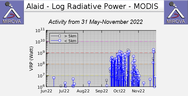 |
Figure 10. Strong thermal anomalies were detected at Alaid beginning in mid-September and continued through late November 2022, according to this MIROVA graph (Log Radiative Power). The peak of these anomalies coincides with the time during which an active lava flow was observed descending the S flank. After strong explosive activity during October, the temperature of the thermal activity gradually began to decrease in early November, though anomalies continued to be detected. The later spike in activity toward the end of November correlates with explosive activity that generated ash plumes. Courtesy of MIROVA. |
An ash plume detected in HIMAWARI-8 satellite imagery on 10 September rose to 3 km altitude (about 700 m above the summit at 2,285 m) and drifted SE, according to the Tokyo VAAC. KVERT reported that a strong thermal anomaly was detected over the volcano at 1139 on 15 September, which was considered the beginning of a Strombolian explosive eruption. A VONA (Volcano Observatory Notice for Aviation) issued on 18 September reported a gas-and-steam plume containing some ash that rose to 2.6 km altitude and drifted 32-50 km ESE, based on satellite images (figure 11). On 21 September ash plumes rose to 2.7 km altitude and drifted E and NE, based on a report from the Tokyo VAAC. During 26-27 September ash plumes rose to 3 km altitude and drifted 65-140 km ESE, NE, SE, and E. According to KVERT, a lava flow began to effuse on the S flank during 27-28 September; that flow remained active through at least 26 November, based on clear weather Sentinel-2 infrared images (figure 12).
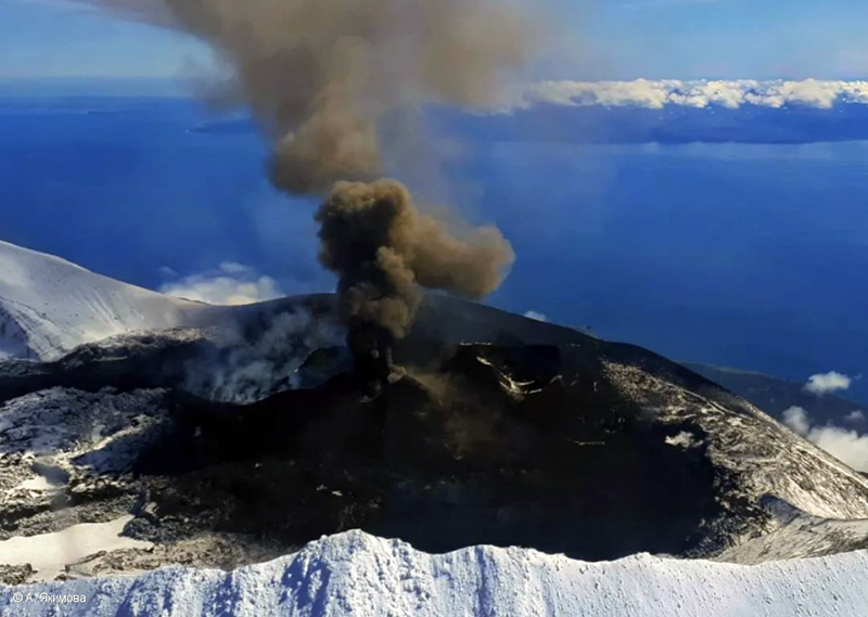 |
Figure 11. Photo of the explosive Strombolian eruption at Alaid on 18 September 2022 with a dark gray ash plume rising about 300 m above the summit and drifting E and NE. Courtesy of A. Yakimova, KVERT. |
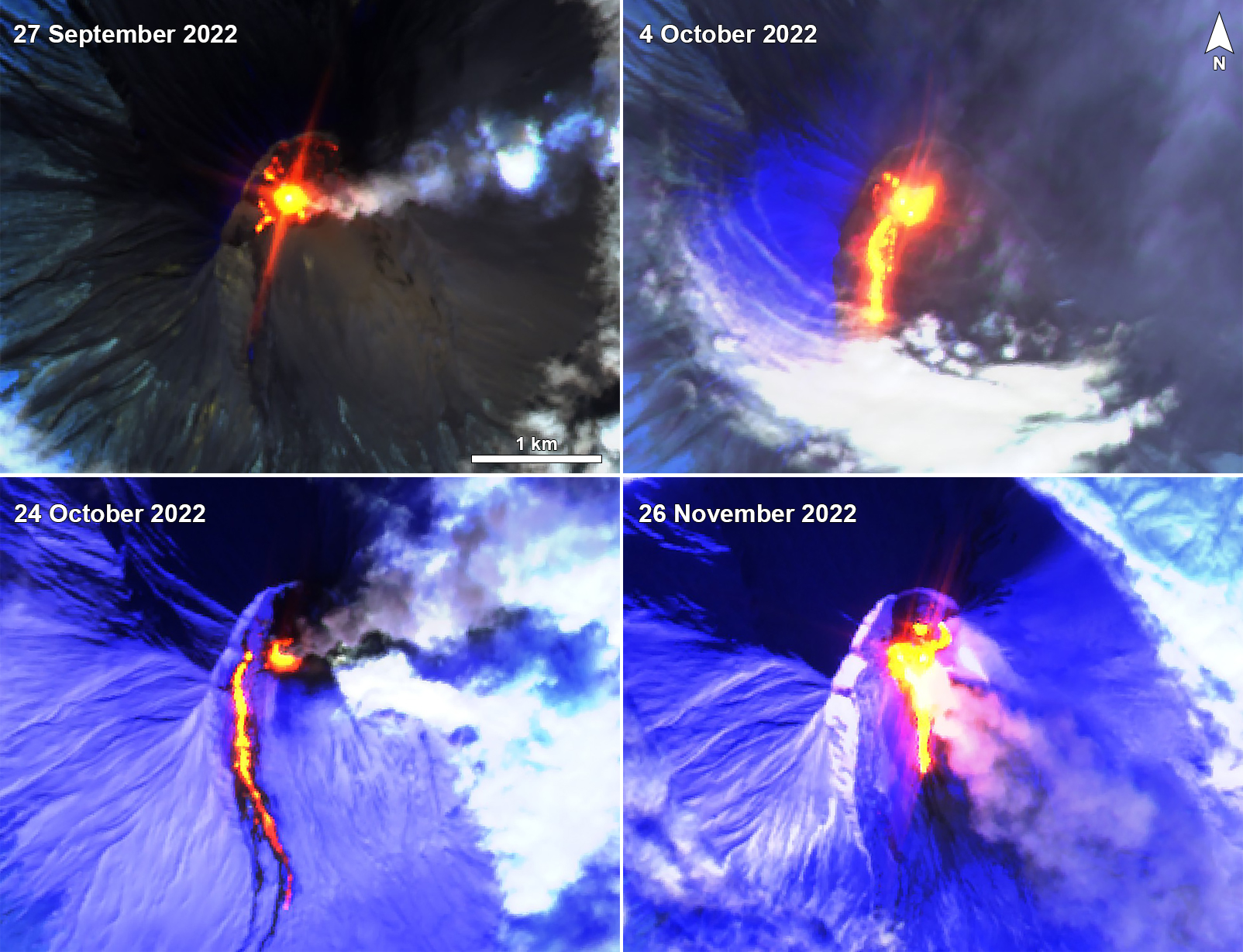 |
Figure 12. Sentinel-2 infrared satellite imagery showing a strong thermal anomaly at the summit crater of Alaid on 27 September (top left), 4 October (top right), 24 October (bottom left), and 26 November 2022 (bottom right). An active lava flow was also visible on the S flank during the latter three dates, accompanied by strong gas-and-ash plumes. Images with “Atmospheric penetration” (bands 12, 11, 8A) rendering. Courtesy of Sentinel Hub Playground. |
Strong thermal activity, intermittent explosions, and ash plumes were reported during October. An intense thermal anomaly was observed during 13-16 and 20 October when weather did not obscure the views. On 14 October ash plumes rose to 3.5 km altitude and drifted 32-343 km E and ESE. Explosive activity increased on 15 October, when ash plumes rose to 5-6.5 km altitude (4.3 km above the summit) and drifted 152-360 km E and ESE. On 16 October ash plumes rose to 3-3.7 km altitude and drifted 145-293 km ESE. Explosions on 24 October produced an ash plume that rose to 3.5 km altitude and extended 72-460 km ENE. On 26 October an ash plume rose to 3 km altitude and drifted 60-700 km E. Satellite data showed that the temperature of thermal activity began to decrease on 29 October.
During November, activity continued to gradually decrease, according to KVERT. Thermal anomalies continued to be detected occasionally throughout the month. Satellite images captured at 1025 on 26 November showed ash plumes from explosions rising to 4.5-4.7 km altitude and drifting 38 km SE. Explosions continued throughout the day; at 1521 ash plumes had risen to 3.5 km altitude and drifted as far as 220 km SE. Ground observations showed a small ash plume coming from the crater, ash deposits, and a plume rising from the S flank where the lava flow was likely contacting snow (figure 13). According to KVERT, no further ash emissions were detected after 26 November and the temperature of the thermal anomaly had decreased to background levels by 1 December.
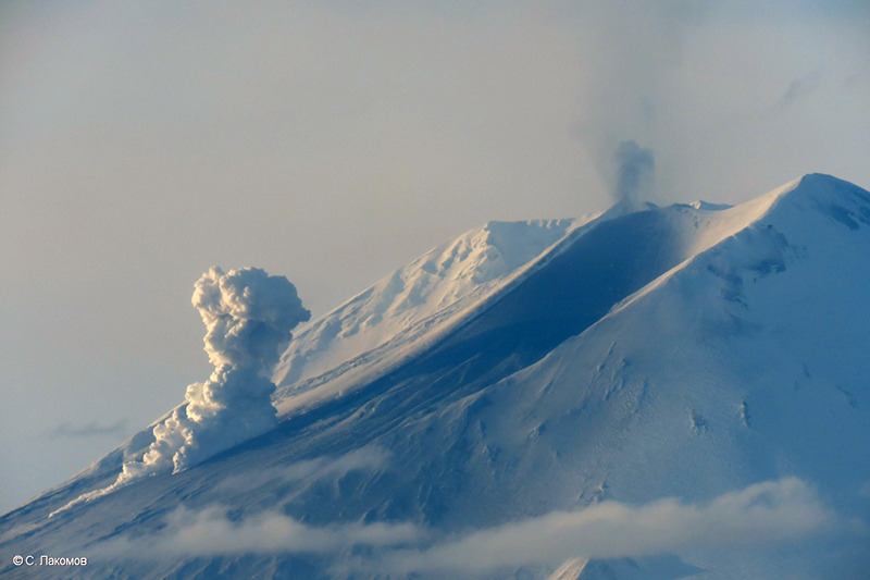 |
Figure 13. Photo of an eruption at Alaid with a small ash plume rising from the summit crater and a lava flow on the S flank on 26 November 2022. Ash deposits are visible on the snow and a larger plume from the end of the lava flow is likely due to interaction with snow. Photo has been color corrected. Courtesy of S. Lakomov, KVERT. |
Information Contacts: Kamchatka Volcanic Eruptions Response Team (KVERT), Far Eastern Branch, Russian Academy of Sciences, 9 Piip Blvd., Petropavlovsk-Kamchatsky, 683006, Russia (URL: http://www.kscnet.ru/ivs/kvert/); Tokyo Volcanic Ash Advisory Center (VAAC), 1-3-4 Otemachi, Chiyoda-ku, Tokyo 100-8122, Japan (URL: http://ds.data.jma.go.jp/svd/vaac/data/); MIROVA (Middle InfraRed Observation of Volcanic Activity), a collaborative project between the Universities of Turin and Florence (Italy) supported by the Centre for Volcanic Risk of the Italian Civil Protection Department (URL: http://www.mirovaweb.it/); Hawai'i Institute of Geophysics and Planetology (HIGP) - MODVOLC Thermal Alerts System, School of Ocean and Earth Science and Technology (SOEST), Univ. of Hawai'i, 2525 Correa Road, Honolulu, HI 96822, USA (URL: http://modis.higp.hawaii.edu/); Sentinel Hub Playground (URL: https://www.sentinel-hub.com/explore/sentinel-playground).
2024: August
2022: September
| October
| November
| December
2019: September
2018: August
2016: February
| March
| April
| May
| June
| July
| August
2015: September
| October
2013: January
2012: October
2010: May
2003: October
| November
| December
Although Alaid was not erupting, KVERT issued a Volcano Observatory Notice for Aviation (VONA) at 0307 on 16 August raising the Aviation Color Code to Orange (the second highest level on a four-color scale) to warn pilots of ash. Satellite images showed a plume of ash, that had been resuspend from the S flank, drifting 45 km SSE at altitudes of 2.5-3 km (8,200-10,000 ft) a.s.l. The Aviation Color Code was lowered back to Green at 0545 that same day. Dates are based on UTC times; specific events are in local time where noted.
Source: Kamchatkan Volcanic Eruption Response Team (KVERT)
KVERT lowered the Aviation Color Code for Alaid to Yellow (the second lowest level on a four-color scale) on 30 December and then to Green on 4 January. Ash plumes were last observed on 26 November and the temperature of the thermal anomaly was at background levels since 1 December.
Source: Kamchatkan Volcanic Eruption Response Team (KVERT)
KVERT reported that a thermal anomaly over Alaid was identified in satellite images on 17 and 22 December; weather clouds obscured observations on the other days during 16-21 December. The Aviation Color Code remained at Orange (the second highest level on a four-color scale). Dates are based on UTC times; specific events are in local time where noted.
Source: Kamchatkan Volcanic Eruption Response Team (KVERT)
KVERT reported that the eruption at Alaid was ongoing during 8-15 December. A thermal anomaly was identified in satellite images on 8, 12, and 14 December; weather clouds obscured observations on the other days. The Aviation Color Code remained at Orange (the second highest level on a four-color scale). Dates are based on UTC times; specific events are in local time where noted.
Source: Kamchatkan Volcanic Eruption Response Team (KVERT)
KVERT reported that the eruption at Alaid was ongoing during 1-8 December. A thermal anomaly was identified in satellite images on 2 and 8 December; weather clouds obscured observations on the other days. The Aviation Color Code remained at Orange (the second highest level on a four-color scale). Dates are based on UTC times; specific events are in local time where noted.
Source: Kamchatkan Volcanic Eruption Response Team (KVERT)
KVERT reported that the eruption at Alaid was ongoing during 25 November-1 December. A daily thermal anomaly was identified in satellite images. Ash plumes drifted 220 km SE during 25-26 November. The Aviation Color Code remained at Orange (the second highest level on a four-color scale). Dates are based on UTC times; specific events are in local time where noted.
Source: Kamchatkan Volcanic Eruption Response Team (KVERT)
KVERT lowered the Aviation Color Code for Alaid to Green (the lowest level on a four-color scale) on 24 November noting that activity had been gradually decreasing since the last ash plume was recorded on 26 October. The temperature of the thermal anomaly began decreasing on 29 October and reached background levels by 20 November. At 1025 on 26 November (local time) ash plumes from explosions were visible in satellite images drifting 38 km SE at altitudes of 4.5-4.7 km 14,800-15,400 ft) a.s.l. The Aviation Color Code was raised to Orange. Explosions continued through the day; by 1521 (local time) ash plumes were rising to 3.5 km (11,500 ft) a.s.l. and ash plumes had drifted as far as 220 km SE. Dates are based on UTC times; specific events are in local time where noted.
Source: Kamchatkan Volcanic Eruption Response Team (KVERT)
KVERT lowered the Aviation Color Code for Alaid to Yellow (the second lowest level on a four-color scale) on 17 November noting that activity had been gradually decreasing since the last ash plume was recorded on 26 October. A thermal anomaly continued to periodically be identified in satellite images when weather conditions permitted views, though the temperature of the thermal anomaly began decreasing on 29 October. Dates are based on UTC times; specific events are in local time where noted.
Source: Kamchatkan Volcanic Eruption Response Team (KVERT)
KVERT reported that the eruption at Alaid was ongoing during 3-10 November. A weak thermal anomaly was identified in satellite images on 3, 6, and 8-9 November; the volcano was obscured by clouds the other days of the week. On 10 November, KVERT reported that the eruptive activity was gradually decreasing. The Aviation Color Code remained at Orange (the second highest level on a four-color scale). Dates are based on UTC times; specific events are in local time where noted.
Source: Kamchatkan Volcanic Eruption Response Team (KVERT)
KVERT reported that the eruption at Alaid was ongoing during 27 October-3 November. A daily thermal anomaly was identified in satellite images. The Aviation Color Code remained at Orange (the second highest level on a four-color scale). Dates are based on UTC times; specific events are in local time where noted.
Source: Kamchatkan Volcanic Eruption Response Team (KVERT)
KVERT reported that the eruption at Alaid was ongoing during 20-27 October. An intense daily thermal anomaly was identified in satellite images. Ash plumes drifted more than 700 m NE and SE. The Aviation Color Code remained at Orange (the second highest level on a four-color scale). Dates are based on UTC times; specific events are in local time where noted.
Source: Kamchatkan Volcanic Eruption Response Team (KVERT)
KVERT reported that the eruption at Alaid was ongoing during 14-20 October. An intense thermal anomaly was identified in satellite images during 13-16 and 20 October; weather clouds obscured views on the other days. Explosive activity during 13-16 October generated ash plumes that rose as high as 6.5 km (21,300 ft) a.s.l. and drifted 360 km E and SE. The Aviation Color Code remained at Orange (the second highest level on a four-color scale). Dates are based on UTC times; specific events are in local time where noted.
Source: Kamchatkan Volcanic Eruption Response Team (KVERT)
KVERT reported that the eruption at Alaid was ongoing during 7-14 October and a daily thermal anomaly was identified in satellite images. Explosive activity on 16 October generated ash plumes that rose to 3.7 km (12,100 ft) a.s.l. and drifted 293 km ESE. The Aviation Color Code remained at Orange (the second highest level on a four-color scale). Dates are based on UTC times; specific events are in local time where noted.
Source: Kamchatkan Volcanic Eruption Response Team (KVERT)
KVERT reported that a new lava flow descended Alaid’s S flank during 27-28 September and continued to be active at least through 6 October; a thermal anomaly was identified in satellite images throughout that same period of time. The Aviation Color Code remained at Orange (the second highest level on a four-color scale). Dates are based on UTC times; specific events are in local time where noted.
Source: Kamchatkan Volcanic Eruption Response Team (KVERT)
KVERT reported that a thermal anomaly over Alaid was identified in satellite images during 22-30 September. Ash plumes were visible drifting 140 km NE and SE during 26-27 September. The Aviation Color Code remained at Orange (the second highest level on a four-color scale). Dates are based on UTC times; specific events are in local time where noted.
Source: Kamchatkan Volcanic Eruption Response Team (KVERT)
KVERT reported that a thermal anomaly over Alaid was identified in satellite images during 15-22 September. On 18 September an ash plume drifted 50 km E. The Aviation Color Code remained at Orange (the second highest level on a four-color scale). Dates are based on UTC times; specific events are in local time where noted.
Source: Kamchatkan Volcanic Eruption Response Team (KVERT)
KVERT reported that an intense thermal anomaly over Alaid identified in satellite images beginning at 1139 on 15 September (local time) likely indicated the onset of a Strombolian eruption. The Aviation Color Code was raised to Yellow (the second lowest level on a four-color scale) the next day. Satellite images acquired at 1108 on 18 September showed a gas-and-steam plume containing ash drifting ESE. Several photographs of the eruption were taken that same day. The Aviation Color Code was raised to Orange.
Sources: Kamchatkan Volcanic Eruption Response Team (KVERT); Institute of Volcanology and Seismology (IVS) of the Far Eastern Branch of the Russian Academy of Sciences (FEB RAS)
The Tokyo VAAC reported that on 10 September an ash plume from Alaid identified in satellite images rose to an altitude of 3 km (10,000 ft) a.s.l. and drifted SE.
Source: Tokyo Volcanic Ash Advisory Center (VAAC)
The Tokyo VAAC reported that on 11 September an ash plume from Alaid identified in satellite images rose to an altitude of 3 km (10,000 ft) a.s.l. and drifted SE.
Source: Tokyo Volcanic Ash Advisory Center (VAAC)
The Tokyo VAAC reported that on [21] August an ash plume from Alaid identified in satellite images rose to an altitude of 2.7 km (9,000 ft) a.s.l. and drifted SE.
Source: Tokyo Volcanic Ash Advisory Center (VAAC)
KVERT reported that moderate activity at Alaid’s summit crater was detected during 5-12 August. Satellite images showed a weak thermal anomaly at the volcano during 6-7 and 11 August. The Aviation Color Code was lowered to Yellow (the second lowest level on a four-color scale).
Source: Kamchatkan Volcanic Eruption Response Team (KVERT)
KVERT reported that moderate activity at Alaid’s summit crater was detected during 29 July-5 August. Satellite images showed a thermal anomaly at the volcano during 2-3 August. The Aviation Color Code remained at Orange (the second highest level on a four-color scale).
Source: Kamchatkan Volcanic Eruption Response Team (KVERT)
KVERT reported that Strombolian activity at a new cinder cone in Alaid’s summit crater was detected during 22-29 July, with lava flowing down the SW flank. On 26 July satellite images showed a thermal anomaly at the volcano, and a gas-and-steam plume that drifted 155 km NE. The Aviation Color Code remained at Orange (the second highest level on a four-color scale).
Source: Kamchatkan Volcanic Eruption Response Team (KVERT)
KVERT reported that Strombolian activity at a new cinder cone in Alaid's summit crater was detected during 15-22 July, with lava flowing down the SW flank. Satellite images showed a thermal anomaly at the volcano during 19-21 July. The Aviation Color Code remained at Orange (the second highest level on a four-color scale).
Source: Kamchatkan Volcanic Eruption Response Team (KVERT)
KVERT reported that Strombolian activity at a new cinder cone in Alaid's summit crater was detected during 8-15 July, with lava flowing down the SW flank. Satellite images showed a thermal anomaly at the volcano during 7 and 11-13 July. The Aviation Color Code remained at Orange (the second highest level on a four-color scale).
Source: Kamchatkan Volcanic Eruption Response Team (KVERT)
KVERT reported that Strombolian activity at a new cinder cone in Alaid's summit crater was detected during 1-8 July, and lava flowed down the SW flank. Satellite images showed a daily thermal anomaly at the volcano, and ash plumes drifting 150 km SW during 3-4 July. The Aviation Color Code remained at Orange (the second highest level on a four-color scale).
Source: Kamchatkan Volcanic Eruption Response Team (KVERT)
KVERT reported that moderate activity at Alaid continued during 24 June-1 July. Satellite images showed a thermal anomaly at the volcano during 28-30 June. The Aviation Color Code remained at Orange (the second highest level on a four-color scale).
Source: Kamchatkan Volcanic Eruption Response Team (KVERT)
KVERT reported that moderate activity at Alaid continued during 17-24 June. Satellite images showed a thermal anomaly over the volcano during 18, 20, and 22-23 June. The Aviation Color Code remained at Orange (the second highest level on a four-color scale).
Source: Kamchatkan Volcanic Eruption Response Team (KVERT)
KVERT reported that moderate activity at Alaid continued during 10-17 June. Satellite images showed a thermal anomaly over the volcano during 9, 11, and 13-14 June. The Aviation Color Code remained at Orange (the second highest level on a four-color scale).
Source: Kamchatkan Volcanic Eruption Response Team (KVERT)
KVERT reported that moderate activity at Alaid continued during 3-10 June. Satellite images showed a thermal anomaly over the volcano during 7-9 June. The Aviation Color Code remained at Orange (the second highest level on a four-color scale).
Source: Kamchatkan Volcanic Eruption Response Team (KVERT)
KVERT reported that moderate activity at Alaid continued during 27 May-3 June. Satellite images showed a thermal anomaly over the volcano on 29 May. The Aviation Color Code remained at Orange (the second highest level on a four-color scale).
Source: Kamchatkan Volcanic Eruption Response Team (KVERT)
KVERT reported that moderate activity at Alaid continued during 20-27 May. Satellite images showed a thermal anomaly over the volcano during 20-21 May. The Aviation Color Code remained at Orange (the second highest level on a four-color scale).
Source: Kamchatkan Volcanic Eruption Response Team (KVERT)
KVERT reported that moderate activity at Alaid continued during 13-20 May. Satellite images showed an intense thermal anomaly over the volcano during 13-16 May. The Aviation Color Code remained at Orange (the second highest level on a four-color scale).
Source: Kamchatkan Volcanic Eruption Response Team (KVERT)
KVERT reported that moderate activity at Alaid continued during 6-13 May. Satellite images showed an intense daily thermal anomaly over the volcano and a lava flow on the SW flank. The Aviation Color Code remained at Orange (the second highest level on a four-color scale).
Source: Kamchatkan Volcanic Eruption Response Team (KVERT)
KVERT reported that moderate activity at Alaid continued during 29 April-6 May. Satellite images showed an intense daily thermal anomaly over the volcano. The Aviation Color Code remained at Orange (the second highest level on a four-color scale).
Source: Kamchatkan Volcanic Eruption Response Team (KVERT)
KVERT reported that moderate activity at Alaid continued during 22-29 April. Satellite images showed an intense daily thermal anomaly over the volcano, and an ash plume that drifted 260 km SE on 21 and 23 April. The Aviation Color Code remained at Orange (the second highest level on a four-color scale).
Source: Kamchatkan Volcanic Eruption Response Team (KVERT)
KVERT reported that moderate activity at Alaid continued during 15-21 April. Satellite images showed an intense daily thermal anomaly over the volcano. The Aviation Color Code remained at Orange (the second highest level on a four-color scale).
Source: Kamchatkan Volcanic Eruption Response Team (KVERT)
KVERT reported that moderate activity at Alaid continued during 8-15 April. Satellite images showed an intense daily thermal anomaly over the volcano. An ash plume drifted about 60 km SE on 9 April, and a gas-and-steam plume drifted 65 km E on 11 April. The Aviation Color Code remained at Orange (the second highest level on a four-color scale).
Source: Kamchatkan Volcanic Eruption Response Team (KVERT)
KVERT reported that moderate activity at Alaid continued during 1-8 April. Satellite images showed an intense daily thermal anomaly over the volcano. A gas-and-steam plume containing minor amounts of ash drifted about 40 km SW on 1 April. The Aviation Color Code remained at Orange (the second highest level on a four-color scale).
Source: Kamchatkan Volcanic Eruption Response Team (KVERT)
KVERT reported that moderate activity at Alaid continued during 25 March-1 April. Satellite images showed an intense daily thermal anomaly over the volcano. A gas-and-steam plume continaing minor amounts of ash drifted about 60 km S and SW during 26 and 30-31 March. The Aviation Color Code remained at Orange (the second highest level on a four-color scale).
Source: Kamchatkan Volcanic Eruption Response Team (KVERT)
KVERT reported that moderate activity at Alaid continued during 18-25 March. Satellite images showed an intense thermal anomaly over the volcano during 18 and 21-25 March; cloud cover obscured views during 19-20 March. A gas-and-steam plume containing minor amounts of ash drifted about 90 km NW on 22 March. The Aviation Color Code remained at Orange (the second highest level on a four-color scale).
Source: Kamchatkan Volcanic Eruption Response Team (KVERT)
KVERT reported that during 11-15 and 18 March satellite images had detected an intense thermal anomaly over Alaid; cloud cover obscured views on the other days. Based on reports from observers on Paramushir Island, a gas-and-steam plume containing minor amounts of ash drifted 85 km E on 12 and 14 March. The Aviation Color Code was raised to Orange (the second highest level on a four-color scale).
Source: Kamchatkan Volcanic Eruption Response Team (KVERT)
KVERT reported that during 4-11 March satellite images had detected an intense thermal anomaly over Alaid. Based on satellite images and reports from observers on Paramushir Island, a gas-and-steam plume containing ash drifted 90 km SW on 6 March. The Aviation Color Code was raised to Orange (the second highest level on a four-color scale).
Source: Kamchatkan Volcanic Eruption Response Team (KVERT)
KVERT reported that a gas-and-steam plume containing ash drifted 52 km WSW of Alaid on 4 March. Satellite images had detected an intense thermal anomaly during the previous week. The Aviation Color Code was raised to Orange (the second highest level on a four-color scale).
Source: Kamchatkan Volcanic Eruption Response Team (KVERT)
KVERT reported that an intense thermal anomaly was detected in satellite images over Alaid during 0800-1256 on 21 February. Diffuse ash emissions drifted 50 km E. The Aviation Color Code was raised to Yellow (the second lowest level on a four-color scale).
Source: Kamchatkan Volcanic Eruption Response Team (KVERT)
KVERT reported that moderate activity at Alaid continued during 2-9 October. A thermal anomaly was detected daily over the volcano. The Aviation Color Code remained at Yellow.
Source: Kamchatkan Volcanic Eruption Response Team (KVERT)
KVERT reported that an intense thermal anomaly was detected in satellite images over Alaid starting at 0305 on 2 October, possibly due to the onset of Strombolian activity. The Aviation Color Code was raised to Yellow (the second lowest level on a four-color scale).
Source: Kamchatkan Volcanic Eruption Response Team (KVERT)
According to KVERT, observers on both Paramushir (SE) and Shumshu islands reported weak gas-and-steam plumes containing small amounts of ash from Alaid during 5, 11, 16-17, 23, and 27-28 October 2012. Photos taken on 27 October showed ash deposits on the cone and a small cinder cone growing in the crater. The cone was again covered by ash on 8 November. Seismicity increased on 16 November and remained elevated until 6 December, when it decreased until 10 December. Technical problems prevented seismic recordings after that. Satellite imagery showed a weak thermal anomaly on the volcano until 12 December. On 8 January 2013 the Aviation Color Code was lowered to Green.
Source: Kamchatkan Volcanic Eruption Response Team (KVERT)
According to KVERT, observers on Paramushir Island (SE) reported weak gas-and-steam activity from Alaid during 11 and 16-17 October. A thermal anomaly on the volcano was detected in satellite imagery during 12 and 14-17 October. Cloud cover prevented observations during 19-22 October. Observers on Shumshu Island (50 km E) reported that an ash plume rose 700 m above the crater on 23 October and a thermal anomaly was detected in satellite imagery. The Aviation Color Code remained at Yellow.
Source: Kamchatkan Volcanic Eruption Response Team (KVERT)
According to KVERT, observers on Paramushir Island reported that on 5 October a large gas-and-steam plume from Alaid rose 200 m above the crater. A thermal anomaly on the volcano was detected in satellite imagery for 7.5 hours the next day. The increased activity prompted KVERT to raise the Aviation Color Code to Yellow on 7 October. Satellite imagery detected a thermal anomaly on 15 October.
Source: Kamchatkan Volcanic Eruption Response Team (KVERT)
KVERT reported that on 23 May a gas-and-steam plume from Alaid was seen in satellite imagery drifting 11 km ESE. No other signs of possible increasing activity were seen in imagery or noted by observers on Paramushir Island during 21-28 May. KVERT lowered the Aviation Color Code to Green.
Source: Kamchatkan Volcanic Eruption Response Team (KVERT)
During 12-19 December, KVERT reduced the Concern Color Code at Alaid from Yellow to Green. Seismicity had been slightly above background levels since 31 October, but KVERT seismologists concluded that it was not related to volcanic activity.
Source: Kamchatkan Volcanic Eruption Response Team (KVERT)
During 7-14 November, seismicity was above background levels at Alaid. Spasmodic volcanic tremor occurred and a large number of weak local earthquakes were recorded. Clouds obscured satellite images of the volcano. Alaid remained at Concern Color Code Yellow.
Source: Kamchatkan Volcanic Eruption Response Team (KVERT)
KVERT raised the Concern Color Code at Alaid from Green to Yellow on 4 November.
Source: Kamchatkan Volcanic Eruption Response Team (KVERT)
Reports are organized chronologically and indexed below by Month/Year (Publication Volume:Number), and include a one-line summary. Click on the index link or scroll down to read the reports.
Long fissure eruption sends ash plume more than 8 km high
Card 1405 (22 June 1972) Powerful eruption sends plume to over 8 km altitude
The Insitute of Volcanology at Petropavlovsk-Kamchatskiy reports a powerful underwater eruption of the volcano Alaid, situated on the Kuril Island of that name. A report has come from southern Kamchatka on the fall of volcanic ash. Traces of the eruption were observed from an aircraft on snowcaps on Paramushir Island. Experts of the Volcanology Institute were unable to approach Alaid because of the black dust clouds. Flying from the southwest, the volcanologists witnessed the eruption of the volcano. According to the scientists' reports, a rain of volcanic particles fell on the coast and on the water, while the cloud reached an altitude of over 8 km and was 5-6 km wide.
Card 1406 (26 June 1972) Eruptive fissure extends into the sea
The following cable was received on 26 June. "June 19 submarine eruption volcano Alaid began. Fissure going into sea for some kilometers has formed at northwest foot volcano Alaid June 20. Eruptive cloud reached 8 km height, 5-6 km width black steam gaseous mixture had greatest thickness 2-4 km from island shoreline. Outbursts periodicity from shore funnels approximately 1.5 minute."
Information Contacts:
Card 1405 (22 June 1972) Y. M. Doubik, IV.
Card 1406 (26 June 1972) Dr. Khrenof, IV.
New vent on NW flank
Card 1410 (10 July 1972) New vent on NW flank
The following was received on 10 July. "July 3 new adventive cone on northwest flank reached height 120 m, width 350 m. Only steam emission from upper explosive crater. From lower crater every two seconds lava bombs outburst to height of 500 m. Flow is typical blocky basalt, thickness 15 m, average width 500 m, length 1.3 km; entered sea and formed peninsula 06 to 06 km."
Information Contacts: Y.M. Doubik, IV.
Explosive activity ceased on 15 August
Card 1518 (27 December 1972) Explosive activity ceased on 15 August
The following was received on 27 December. "Explosive activity ceased on 15 August. Lava effusion ceased on 11 September. Total tephra and lava volume reached 1 km3. New lateral craters display only fumarolic activity now."
Information Contacts: Y.M. Doubik, IV.
Strong explosive eruption; ashfalls to more than 1,000 km
Soviet volcanologists reported that an explosive summit eruption from Alaid, on uninhabited Atlasova Island, began after midday on 27 April and intensified the next day. Much of the information on the eruption from both U.S. and Soviet sources is from analysis of satellite imagery. Clouds prevented satellite observations until about 0715 on the 28th, when infrared imagery from the NOAA 6 polar orbiter revealed a distinct V-shaped eruption plume that extended a short distance NE from the volcano before disappearing in heavy weather clouds. An infrared image returned from the GMS at 1100 showed a similar pattern. Microbarographs at Kushiro Weather Observatory (about 1,250 km SW of Alaid) recorded three distinct pressure waves on 28 April: at 1143 (0.5 millibars), 1153 (0.2 millibars), and 1340 (0.8 millibars).
Vigorous feeding of this cloud could be seen on the satellite imagery for the next 2 days (figure 1). 29 April imagery indicated that the plume consisted of two primary layers, at about 9-11 km and 13.5-15 km altitude. The last clear-weather image, on 30 April at 1700, showed a plume at least 120 km wide and 1,900 km long. Eighteen hours later (1100 on 1 May, 4 days after the eruption began) partial clearing showed that feeding of the plume had apparently ended. Weather obscured the area on images from 30 April at 2300 to 1 May at 1100, when partial clearing showed that feeding of the plume had apparently ended.
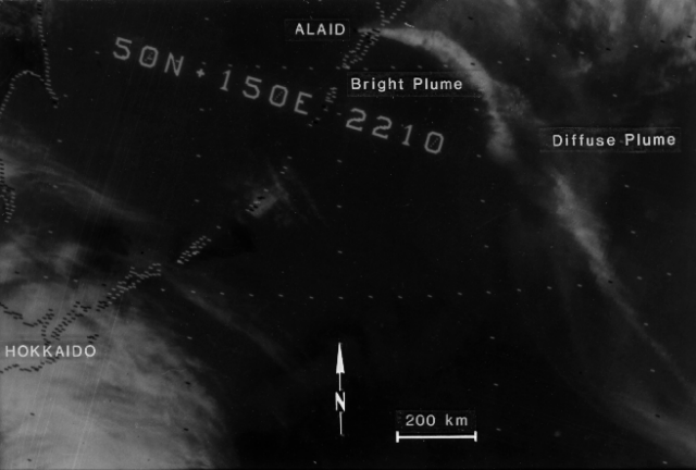 |
Figure 1. NOAA 6 satellite image, returned 30 April at 0910, showing eruption plumes from Alaid. The image was obtained using the 11 µm thermal infrared sensor. Image resolution is 4 km. Two plumes are evident, one bright and distinct. the other diffuse, but well-defined. The plumes are over 1,700 km in length, trailing off the right side of the image. Analysis of the imagery shows that the brighter plume has a temperature of about -55°C, and the diffuse plume an apparent temperature of -10°C. Comparison of the temperature of the colder (and therefore higher) of the two plumes with radiosonde temperature profiles collected from Petropavlovsk. Kamchatka (300 km NE of the volcano) and Podgornoye, Paramushir Island (50 km S of the volcano) yielded two possible altitudes for this plume; 9.8-10.4 km if it had not passed through the tropopause (at 11.6 km), or 13.7-14.3 km if the plume was stratospheric. The image and caption information were provided by Michael Matson. |
Significant ashfalls were reported over a wide area. Soviet volcanologists reported that the ash, a pyroxene olivine basalt, fell as much as 1,000 km from the volcano, over an area of 150,000 km2. They noted an accumulation of 30 cm of ash 7 km from Alaid, and Tass reported that 20-25 cm fell on the town of Severokurilsk (45 km ESE of the volcano), where residents heard roaring noises and saw a glow from the volcano during the night. Schools were closed in Severokurilsk and radio communication was disrupted. Ash mixed with wet snow fell on Petropavlovsk (300 km NE of the volcano) and other inhabited areas on the Kamchatka Peninsula. In the Aleutians, ashfall began 28 April on Shemya (about 1,200 km ENE of Alaid), and lasted all day 30 April and 1 May, when roughly 2 mm of ash were measured in very windy weather. Lt. Becker observed intermittent ashfalls and periods of acid rain between 2 and 5 May, always within 1.5 hours after low ocean tide. Ash collected at Shemya was sent to the NASA Ames Research Center. Daily precipitation sampling from Adak Island (650 km E of Shemya and 1900 km from Alaid) 1-7 May yielded only a trace of ash, on the 4th.
Tass reported that volcanologists overflew the volcano 29 April and observed an ash column that rose to about 10 km altitude from the summit crater. Soviet volcanologists later reported a maximum eruption cloud height during the activity of 12 km, based on overflights and analysis of satellite imagery.
Soviet volcanologists reported that activity declined 2-4 May. No additional activity was observed on satellite imagery until 8 May at 2300, when the GMS satellite recorded a new eruption column starting to emerge from Alaid. Careful examination of earlier imagery from other satellites indicates that the renewed activity may have started as early as 1930. By 9 May at 0300, a dense plume extended more than 120 km to the ESE. This plume remained shorter and much narrower than the late April clouds, reaching a maximum length of about 400 km ESE from the volcano. GMS imagery continued to show strong feeding of the cloud at 1100, but the eruption seemed to be weakening by 1400 and had apparently ended by the time of the next available image at 2000.
Attempts to observe and sample the ejecta farther downwind continue. During the night of 6-7 May, lidar operated by SRI International near San Francisco, California detected two distinct layers of material at 11.9 and 12.8 km altitude, just below the tropopause. However, it was not possible to confirm that this material was of volcanic origin.
A preliminary search for strong seismicity associated with the eruption yielded only a single shallow magnitude 6.0 event at 44.04°N, 149.93°E (860 km SSW of the volcano), on 1 May at 0142.
Information Contacts: S. Fedotov and B. Ivanov, IVP; F. Smigielski, S. Arnett, and M. Matson, NOAA/NESS; G. Telegadas, NOAA/ARL; D. Shimozuru, Univ. of Tokyo; R. Muñoz, NASA, Ames Research Center; M. McCormick, NASA, Langley Research Center; P. Russell, SRI International; Lt. Becker, USAF, Shemya AK; Tass; USGS/NEIS.
April-May eruption detailed
G.S. Steinberg provided the following additional information on the early stages of the eruption. Activity began 27 April with the emission of a small white plume. The magnitude of the explosions increased rapidly, soon building a black ash column more than 10 km high. Ashfall was intense at Severokurilsk (45 km ESE of the volcano), and by the end of 27 April as much as 20 cm had been deposited there. Schools and kindergartens were closed the next day and water collecting facilities were disrupted by the ash. The wind changed direction 29 April, blowing the eruption cloud NE. At Petropavlovsk, 300 km to the NE, an estimated 1.5 kg/m2 of ash had accumulated by the end of 29 April. The eruption reached its maximum intensity 30 April-1 May. Activity began to decrease 2 May, was limited to ejection of ash and larger tephra to less than 100 m height by 4-5 May, and stopped 7 May.
Michael Matson provided the following satellite data. Plumes of varying langths were intermittently present through late May on imagery (at about 0730 each day) from the NOAA 6 polar orbiting satellite. The minor activity reported by Steinberg after 2 May could not be seen on the images, but a small plume from Alaid appeared 7 May. On 8 May, a plume extended about 350 km from Alaid, but 24 hours later it was only about 60 km long. There was a plume on the 10 May imagery, but no activity was evident 11-14 May. A very small plume reappeared 15 May, had grown to 250 km long by the 17th, and persisted, at lengths that varied from 50 to nearly 600 km, through 27 May (weather clouds obscured the volcano 19 and 25 May). Alaid appeared to emit a plume no more than 25 km long on 1 June. No additional activity was evident on the satellite imagery through 9 June.
Further References. Fedotov, S.A., Ivanov, B.V., Avdeyko, G.P., Flerov, G, and others, 1981, The 1981 eruption of Alaid volcano: Volcanology and Seismology, 1981, no. 5, p. 82-87.
Sawada, Y., 1983, Analysis of eruption clouds by the 1981 eruptions of Alaid and Pagan volcanoes with GMS images: Papers in Meteorology and Geophysics, v. 34, p. 307-324.
Information Contacts: G. Steinberg, Sakhalin Complex Institute; M. Matson, NOAA/NESS.
Plume on satellite imagery
Imagery from the GMS satellite revealed a narrow, linear eruption plume emerging from Alaid at 1100 on 29 March. The plume extended roughly 100 km to the ESE and was estimated to be roughly 2 hours old. Images returned 3 hours earlier and later showed no evidence of activity.
Information Contacts: M. Matson, NOAA/NESS.
Collapse of the 1981 cone in the summit crater
Dvigalo and others (1988) report that the major 1981 eruption was not followed by observed changes in crater morphology until 1986. During aerial observations on 25 May 1986, voluminous gas clouds covered the entire crater area, and were occasionally gray from ash. Overflights on 31 May and 9 June revealed that the summit crater's 1981 cone (250 m high and 600 m across at its base) had been almost entirely destroyed. Its former site was occupied by two collapse craters, the larger of which was ~300 m across and 100 m deep. No additional changes were evident during 15 October observations.
Reference. Dvigalo, V.N., Andreev, V.I., Gavrilenko, G.M., Ovsyannikov, A.A., Razina, A.A., and Chirkov, A.M., 1988, Activity of southeast Kamchatka and north Kuriles volcanoes in 1985-1986: Volcanology and Seismology, no. 3, p. 13-20 (in Russian); v. 10, no. 3, p. 347-359 (English translation, 1990).
Information Contacts:
Fumarolic activity in crater
In November 1986, the main fumarolic activity was concentrated in one large vent in the crater. The vent's outer slopes were hot and snow-free while most of the crater area was covered in snow that had fallen September-October. No consistent snow patches had been seen in the crater during autumn 1982 overflights.
A scoria cone had formed within the summit crater during the large 1981 eruption (Fedotov and others, 1981, 1982). During aerial observations in September 1982, fumarolic activity was concentrated at three new vents at the site of this cone. Geologists believed that these vents formed during a brief eruption on 2 March 1982, detected by the GMS satellite. The changed vent distribution was thought to have been the result of an eruption between 1982 and 1986 that was not observed. The volcano is remote and its weather is often poor.
References. Fedotov, S.A., Ivanov, B.V., Avdeiko, G.P., Flerov, G.B., Andreyev, V.N., Dvigalo, V.N., Dubik, Y.M., Cherkov, A.M., 1981, 1981 eruption of the Alaid volcano: Volcanology and Seismology no. 5, p. 82-87.
Fedotov, S.A., Ivanov, B.V., Flerov, G.B., Avdeiko, G.P., Budnikov, V.A., Andreev, V.N., Gordeev, E.I., Dvigalo, V.N., Shirokov, V.A., 1982, Eruption of Alaid volcano (Kurile Islands) in 1981: Volcanology and Seismology, no. 6, p. 9-27.
Information Contacts: G. Steinberg and B. Piskunov, Yuzhno-Sakhalinsk.
Eruption sends a plume 5-6 km high on 3 December
On 3 December, satellite imagery indicated a plume rising to a height of 5-6 km from Alaid. The nearest seismic station, located in the town of Severo-Kurilsk (Paramushir Island), 25 km E of Alaid, recorded the beginning of local seismic activity at about the same time as the satellite report. A large snow storm obscured the volcano, and no visual reports of eruptive activity were received from the coast guard, ships, or aircraft in the area.
Information Contacts: Tom Miller, Alaska Volcano Observatory (AVO), a cooperative program of a) U.S. Geological Survey, 4200 University Drive, Anchorage, AK 99508-4667, USA (URL: http://www.avo.alaska.edu/), b) Geophysical Institute, University of Alaska, PO Box 757320, Fairbanks, AK 99775-7320, USA, and c) Alaska Division of Geological & Geophysical Surveys, 794 University Ave., Suite 200, Fairbanks, AK 99709, USA; Vladimir Kirianov, Kamchatka Volcanic Eruptions Response Team (KVERT), Institute of Volcanic Geology and Geochemistry, Piip Ave. 9, Petropavlovsk-Kamchatsky, 683006, Russia; NOAA/NESDIS Satellite Analysis Branch; Room 401, 5200 Auth Road, Camp Springs, MD 20746, USA.
Hot spot seen on satellite imagery; ashfall on Kamchatka
On 23 August a possible hot spot at Alaid was reported to be visible on U.S. satellite imagery. The Russian Coast Guard informed the Kamchatka Volcanic Eruptions Response Team (KVERT) that ash had fallen on the SW part of the Kamchatka Peninsula. No ashfalls or other signs of eruptive activity were reported at Severo-Kurilsk (Paramushir Island), 25 km E of the volcano, or from a fishing vessel 10 km from the volcano.
Information Contacts: Vladimir Kirianov, Kamchatka Volcanic Eruptions Response Team (KVERT), Institute of Volcanic Geology and Geochemistry, Piip Ave. 9, Petropavlovsk-Kamchatsky, 683006, Russia; Tom Miller, Alaska Volcano Observatory (AVO), a cooperative program of a) U.S. Geological Survey, 4200 University Drive, Anchorage, AK 99508-4667, USA (URL: http://www.avo.alaska.edu/), b) Geophysical Institute, University of Alaska, PO Box 757320, Fairbanks, AK 99775-7320, USA, and c) Alaska Division of Geological & Geophysical Surveys, 794 University Ave., Suite 200, Fairbanks, AK 99709, USA.
Volcanic tremor detected beginning on 31 October
On 4 November 2003 the Level of Concern Color Code was raised to Yellow due to volcanic tremor that began on 31 October. Weak seismicity continued through 7 November. Volcanic tremor during this time was 0.5-3.3 x 10⁻⁶ mps, and a large number of weak local events were registered. On satellite images the volcano was obscured by clouds all week.
The Kamchatkan Volcanic Eruption Response Team notes that Alaid is characterized by two types of eruptions: central crater eruptions and lateral eruptions. Central crater eruptions are stronger and more dangerous then the lateral ones. The strongest central crater eruptions of Alaid were in February 1793, June 1854, July 1860, 1894, and April 1981. The April 1981 eruption sent an ash plume to 8,000-9,000 m altitude that extended for more than 1,500 km (SEAN 06:04 and 06:05). Two eruptions in 1933-1934 and 1972 (CSLP Cards nos. 1405, 1406, 1410, and 1518) ejected ash columns 3 km high.
Satellite imagery indicated possible activity in March 1982 (SEAN 07:03 and 12:04), 3 December 1996 (BGVN 21:12), and 23 August 1997 (BGVN 22:09).
Information Contacts: Anastasia Tranbenkova, Kamchatka Volcanic Eruptions Response Team (KVERT), a cooperative program of the Institute of Volcanic Geology and Geochemistry, Far East Division, Russian Academy of Sciences, Piip Ave. 9, Petropavlovsk-Kamchatsky, 683006, Russia, the Kamchatka Experimental and Methodical Seismological Department (KEMSD), GS RAS (Russia), and the Alaska Volcano Observatory (USA); Alaska Volcano Observatory (AVO), a cooperative program of the U.S. Geological Survey, 4200 University Drive, Anchorage, AK 99508-4667, USA (URL: http://www.avo.alaska.edu/), the Geophysical Institute, University of Alaska, PO Box 757320, Fairbanks, AK 99775-7320, USA, and the Alaska Division of Geological and Geophysical Surveys, 794 University Ave., Suite 200, Fairbanks, AK 99709, USA.
Weak seismicity, but tremor determined to be wind-related
From 8 November through mid-December 2003 the hazard status of Alaid remained at Yellow. Weak seismic activity has remained slightly above background levels since 31 October. The volcano was also obscured by clouds during this period. Continuous spasmodic volcanic tremor was recorded (0.15-3.4 x 10⁻⁶ m/s), and a large number of weak local events were registered, during each week. The report for the week of 12-19 December indicated that seismologists have now decided that the tremor is probably not of volcanic origin, but has probably been a result of strong winds. The Level of Concern Color Code was lowered to Green on 19 December 2003.
Information Contacts: Olga Girina, Kamchatka Volcanic Eruptions Response Team (KVERT), a cooperative program of the Institute of Volcanic Geology and Geochemistry, Far East Division, Russian Academy of Sciences, Piip Ave. 9, Petropavlovsk-Kamchatsky, 683006, Russia, the Kamchatka Experimental and Methodical Seismological Department (KEMSD), GS RAS (Russia), and the Alaska Volcano Observatory (USA); Alaska Volcano Observatory (AVO), a cooperative program of the U.S. Geological Survey, 4200 University Drive, Anchorage, AK 99508-4667, USA (URL: http://www.avo.alaska.edu/), the Geophysical Institute, University of Alaska, PO Box 757320, Fairbanks, AK 99775-7320, USA, and the Alaska Division of Geological and Geophysical Surveys, 794 University Ave., Suite 200, Fairbanks, AK 99709, USA.
Minor ash plumes on 17 and 23 October and 8 November 2012
Our previous report noted weak seismicity from Alaid during November 2003, although seismologists determined it was not related to volcanic activity (BGVN 28:11). This report discusses activity from December 2003 to January 2014. Emissions were observed in May 2010 and October 2012, but ash was not detected in the plumes until 23 October 2012. The last thermal anomaly was detected in December 2012.
Alaid volcano is located on Atlasova island off the southern tip of Russia's Kamchatka peninsula and represents the northernmost Holocene volcano in the Kuril Islands (figures 2 and 3). Other names for the volcano and island include Araido, Atlasova, Oyakoba, and Uyakhuzhach (Ukviggen, 2013). Despite the islands small size, its summit (2,339 m elevation) is the highest in the Kuriles. The volcano also plays a large and colorful role in the region's folklore (Ukviggen, 2013; Svalova, 1999).
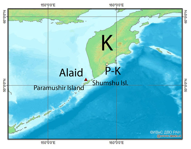 |
Figure 2. A regional map showing Alaid volcano, located S of the Kamchatka Peninsula (K), S of the city Petropavlovsk-Kamchatsky (P-K), and W of Paramushir and Shumshu Islands. Alaid (red triangle) is located at Atlasora Island. The original map was in Russian with authorship information at lower right. Courtesy of Kamchatka Volcanic Eruption Response Team (KVERT). |
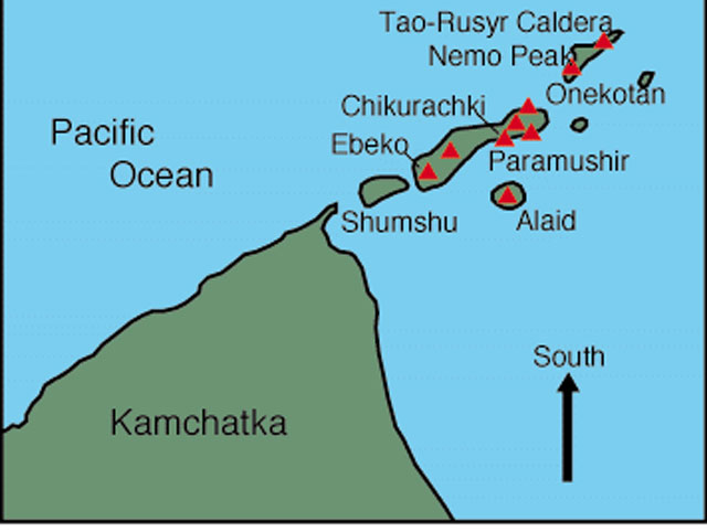 |
Figure 3. A simple map with S towards the top, illustrating Alaid on Atlasov island and some of the adjacent Holocene volcanoes in the Kuriles. Volcanoes on Kamchatka are omitted. Taken from Volcano World. |
On 5 October 2012, (KVERT) changed the Aviation Color Code from Green to Yellow due to "signs of elevated unrest above known background levels." A Volcano Observatory Notification to Aviation (VONA) noted that a possible explosive eruption could produce an ash column height of 10-15 km. Because Alaid is located near many flight routes, an eruption poses hazards to aviation (Girina and others, 2013).
On 23 May a gas-and-steam plume from Alaid was seen in satellite imagery drifting 11 km ESE. No other signs of possible increasing activity were seen in imagery or noted by observers on Paramushir Island during 21-28 May. During 2012, thermal anomalies were detected on 6, 12, 14-17, 19, 23, 27-28 and 30-31 October, 1, 4, 6-9, 12, 14, 20 and 24 November, and 4 and 12 December. At times, satellites could not detect thermal anomalies over Alaid volcano because of cloud cover, for example during the end of December 2012 and the beginning of January 2013. Visual observations from the adjacent Paramushir and Shumshu islands reported steam activity on 5, 11, 16, 17, 23, 26 and 27 October 2012; steam plumes rose 200 m on 5 October and 3 km on 23 October. (KVERT) and Institute of Volcanology and Seismology (IVS) FED RAS photographs showed fumarole activity on 6, 11, 12, 16, 25 and 27 October and 29 November 2012.
Several ash plumes erupting from Alaid volcano were reported in October and November 2012. (KVERT) and (IVS) FED RAS photographs from 17 and 23 October showed steam plumes containing ash rising 700 m. During this time, a small cinder cone grew in the larger summit crater. The volcano and its summit crater can be observed during an interval of inactivity on figure 4. Observers on 8 November 2012 noted that the volcanic cone was covered by ash.
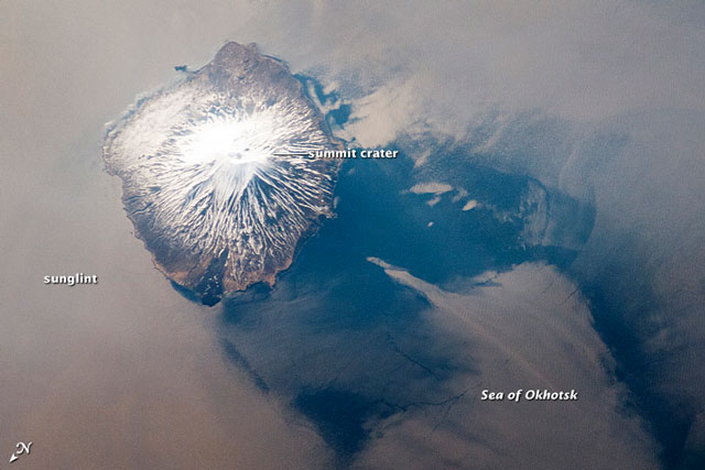 |
Figure 4. Photograph of Alaid during clear viewing conditions taken by the International Space Station's Expedition 31 crew on 18 May 2012. The silver-gray appearance on the sea surface surrounding much of the volcano results from strongly reflected sunlight bounced off the sea surface (sunglint). The image was provided by the ISS Crew Earth Observations experiment and Image Science & Analysis Laboratory, Johnson Space Center (Photo ID, ISS031-E-41959). Courtesy of the International Space Station, the Image Science & Analysis Laboratory at Johnson Space Center, and William L. Stefanov (Jacobs/ESCG at NASA-JSC). |
Because of mechanical problems, seismicity could not be monitored for the majority of the time Alaid was at Aviation Color Code Yellow; seismic data was unavailable from January 2009 until November 2012. The seismic station was repaired on 16 November 2012, and KVERT noted moderate seismic activity. During early December, the amplitude of volcanic tremor was in the range 12.1-18.7 μm/s. After 11 December 2012, technical reasons again prevented further seismic data acquisition.
On 8 January 2013 the Aviation Color Code was reduced to Green, meaning that "volcanic activity was considered to have ceased, and the volcano reverted to its normal, non-eruptive state" (KVERT).
References: Svalova, VB, 1999, Geothermal Legends through History in Russia and the Former USSR: A Bridge to the Past, Geothermal Resources Council Transactions, v. 22 p.235-239. PDF file. (URL: http://pubs.geothermal-library.org/lib/grc/1015911.pdf)
Ukviggen, 2013, Alaid: Part 1–the Banished Beauty, Volcano Cafe, 24 April 2013. Accessed online 13 January 2014. (URL: http://volcanocafe.wordpress.com/2013/04/24/alaid-part-1-the-banished-beauty/)
Girina,O., Manevich, A., Melnikov, D., Nuzhdaev,A., Demyanchuk, Y., and Petrova, E., 2013, Explosive Eruptions of Kamchatkan Volcanoes in 2012 and Danger to Aviation, EGU General Assembly, (abstract), 2013 meeting in Vienna, Austria. (URL: http://adsabs.harvard.edu/abs/2013EGUGA..15.6760G).
Information Contacts: Olga Girina, Kamchatka Volcanic Eruptions Response Team (KVERT), a cooperative program of the Institute of Volcanic Geology and Geochemistry, Far East Division, Russian Academy of Sciences, Piip Ave. 9, Petropavlovsk-Kamchatsky, 683006, Russia; Volcano World (URL: http://volcano.oregonstate.edu/alaid); and International Space Station, the Image Science & Analysis Laboratory at Nasa's Johnson Space Center, and William L. Stefanov (Jacobs Technology).
Moderate eruption that began on 2 October 2015 continued into early 2016
Alaid, a volcano off the southern tip of Russia's Kamchatka peninsula, erupted during October-December 2012, with several ash plumes, steam emissions, and frequent thermal anomalies (BGVN 38:10). A weak thermal anomaly was last detected in mid-December 2012. Eruptive activity resumed beginning in October 2015 and continued into early 2016. Alaid is monitored by the Kamchatka Volcanic Eruptions Response Team (KVERT).
KVERT noted that an intense thermal anomaly was identified in satellite data starting at 0305 on 2 October 2015, which was likely the onset of moderate Strombolian activity. Consequently, KVERT raised the Aviation Color Code to Yellow (the second lowest level on a four-color scale). The report also referred to a Tokyo VAAC notice from 29 September 2015, noting that KBGS RAS had detected increased seismicity at the volcano, though the VAAC notice only stated that a low-level "eruption" had been reported.
During 3 October-25 December 2015 often intense thermal anomalies were detected, though cloud cover often obscured views. Gas-and-steam emissions were first visible on 16 December. Observers on Paramushir Island (the nearest point on the island is 30 km SE of Alaid) indicated that emissions during 28-29 December 2015 contained a small amount of ash. The intensity of the thermal anomaly decreased considerably in January, and then continued to weaken in early February. Steam-and-gas emissions were reported weekly through 28 January 2016. KVERT lowered the Aviation Color Code to Green on 5 February.
Thermal anomalies, based on MODIS satellite instruments analyzed using the MODVOLC algorithm, were observed frequently (but not continuously) beginning on 5 October 2015 and continued through 4 January 2016. The MIROVA (Middle InfraRed Observation of Volcanic Activity) volcano hotspot detection system, also based on analysis of MODIS data, detected frequent hotspots from the beginning of October 2015 through the first week of January 2016, although one low-to-moderate energy hotspot was observed as late as 17 February 2016 about 4 km from the summit.
Information Contacts: Kamchatka Volcanic Eruptions Response Team (KVERT), Far East Division, Russian Academy of Sciences, 9 Piip Blvd., Petropavlovsk-Kamchatsky, 683006, Russia (URL: http://www.kscnet.ru/ivs/); Hawai'i Institute of Geophysics and Planetology (HIGP) MODVOLC Thermal Alerts System, School of Ocean and Earth Science and Technology (SOEST), Univ. of Hawai'i, 2525 Correa Road, Honolulu, HI 96822, USA (URL: 2/12/2016http://modis.higp.hawaii.edu/); MIROVA (Middle InfraRed Observation of Volcanic Activity), a collaborative project between the Universities of Turin and Florence (Italy) supported by the Centre for Volcanic Risk of the Italian Civil Protection Department (URL: http://www.mirovaweb.it/).
Ash plumes and lava flow, October 2015 to August 2016
Russia's Alaid volcano, located just off the southern tip of the Kamchatka Peninsula, is the northernmost of the chain of volcanoes that comprise the Kuril archipelago. A number of strong explosive eruptions have been recorded there in the last 200 years, including VEI 4 explosions in 1790 and 1981. The last eruption occurred between 5 October and 12 December 2012 when repeated thermal anomalies and ash plumes from the summit crater were observed. A new eruption was first reported on 29 September 2015 by the Tokyo Volcanic Ash Advisory Center (VAAC) (BGVN 41:06). Alaid is monitored by the Kamchatka Volcanic Eruptions Response Team (KVERT); valuable information about this remote site is also gathered from satellite thermal infrared data reported by both the University of Hawai'i's MODVOLC system and the Italian MIROVA system.
A new eruption at Alaid was reported on 29 September 2015. It was characterized by strong thermal anomalies and intermittent gas-and-ash plumes. The thermal anomalies were interpreted by KVERT as Strombolian eruptions and lava flows. The first episode of the eruption exhibited strong thermal anomalies with only two reports of ash, and lasted until 4 January 2016. The second episode began with the reappearance of a strong thermal anomaly and an ash plume on 20 February 2016. This was followed by a series of low-level ash plumes in March and April, and ongoing strong thermal anomalies through early May. The anomalies decreased during mid-May and June, but then a large spike of intense anomalies in the first week of July was accompanied by ash plumes and observations by KVERT of Strombolian eruptions at the summit crater and a lava flow down the SW flank. Thermal activity decreased substantially following this spike, and tapered off completely by the second week of August 2016.
The Tokyo VAAC reported an eruption at Alaid at 2120 UTC on 28 September (0720 on 29 September local time) 2015. They reported it as below 6.1 km altitude, and volcanic ash was not identifiable in satellite images. KVERT raised the Aviation Color Code from Green to Yellow early on 2 October 2015 (local time) based on an intense thermal anomaly observed during the night that they interpreted to be the beginning of a new Strombolian eruption. The first thermal anomalies identified by MIROVA (Middle InfraRed Observation of Volcanic Activity) also appear during the first two days of October (figure 5). MODVOLC thermal alerts first appeared on 5 October and were essentially continuous with no more than a few days break until 4 January 2016. The MIROVA signal remained steady until about the same date when it abruptly decreased. KVERT reported consistent and usually intense thermal anomalies, when the volcano was not obscured by clouds, until 4 January. They observed anomalies in satellite images with decreasing frequency and intensity during the rest of January and into early February.
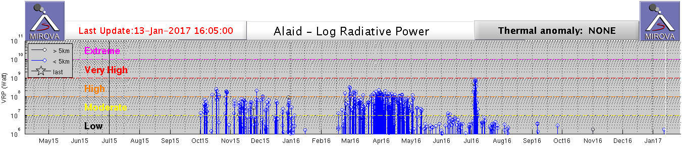 |
Figure 5. MIROVA thermal anomaly data for Alaid from 5 April 2015 through 13 January 2017. The first thermal anomaly is visible on 1 or 2 October 2015. The signal remained consistently in the Moderate to High range until the first week of January when it abruptly stopped. It reappeared during the third week of February and was consistently 'High' until mid-May when it decreased to 'Low' values. A sudden spike to near 'Very High' values during the first week of July corresponded with KVERT reports of Strombolian eruptions from the summit crater and a lava flow down the SW flank. Courtesy of MIROVA. |
The first report of observed gas-and-steam activity (after the Tokyo VAAC report on 29 September) was by KVERT on 16 December. Visual observations from nearby Paramushir Island (45 km SE) noted a small amount of ash in the steam-and-gas plumes on 28 and 29 December. The Tokyo VAAC also reported a plume of volcanic ash at 4.6 km altitude on 29 December drifting SW. On 5 February 2016 local time KVERT lowered the Aviation Color Code (ACC) to Green, noting decreased thermal activity and only moderate continuing fumarole activity during the previous weeks. A break in the thermal activity between early January and late February is also recorded in the MIROVA data (figure 5).
Another eruptive episode began with the appearance of a strong thermal anomaly and a weak ash emission sending a plume 50 km E on 20 February UTC, leading KVERT to raise the ACC back to Yellow. Renewed MIROVA thermal anomalies appeared on 16 or 17 February (figure 5). The first MODVOLC thermal alert was reported 23 February, and they were essentially continuous (except for probable cloudy days) until 5 May 2016. MIROVA thermal anomalies values remained consistently in the 'High' (VRP of 108-109 Watts) range until the second week of May when they dropped back to 'Low' (VRP of 106-107 Watts).
KVERT reported gas-and-steam plumes containing a small amount of ash on 20 and 24 February 2016. Minor ashfall (less than 1 mm) was reported on 24 February in Severo-Kurilsk, 45 km SE on Paramushir Island. The Tokyo VAAC also reported a possible eruption that day with a plume to 3 km altitude extending NE. An ash plume was reported by KVERT and the Tokyo VAAC on 3 March 2016 at 3 km altitude drifting 52 km WSW. This prompted KVERT to raise the ACC to Orange. Ash emissions continued for the next two days, rising to 3.4-3.9 km and drifting S and SW, according to the Tokyo VAAC. KVERT reported visual data from Paramushir Island confirming an ash plume extending SW on 6 March, and satellite data showing the plume 90 km SW that same day.
Possible eruptions were again reported on 11 and 12 March 2016 by the Tokyo VAAC under 3 km altitude, and on 12 and 14 March by KVERT as visual observations from Paramushir extending 85 km E. Weak ash emissions were reported several more times in March and April rising to between 3 and 4.3 km altitude and drifting in various directions (some as far as 90 km) on 22, 26, and 30-31 March, and 1, 9, 14, 18, 21, and 24 April. KVERT noted that on 21 and 23 April the ash plumes extended about 260 km SE. Moderate thermal anomalies were reported by KVERT from mid-May through the beginning of July, and MIROVA anomalies registered in the 'Low' range during this time. KVERT reported on 12 May that satellite data showed a lava flow on the SW flank. They noted continuing thermal anomalies over the volcano during clear weather throughout May and June, but no ash plumes were reported.
KVERT and the Tokyo VAAC once again noted ash plumes that drifted 150 km SW during 3-4 July. This is consistent with an Aura/OMI image of an SO2 plume drifting SW from Alaid on 4 July (figure 6). On 7 July, KVERT reported Strombolian activity from a new cinder cone in the summit crater and a lava flow effusing down the SW flank. A sudden spike in the MIROVA data with values rising to 109 W of Radiative Power during 3-7 July (figure 5) corroborates the KVERT observation of the lava flow; the MODVOLC data also shows a strong signal between 3 and 7 July, including several alert pixels on the SW flank of the volcano (figure 7).
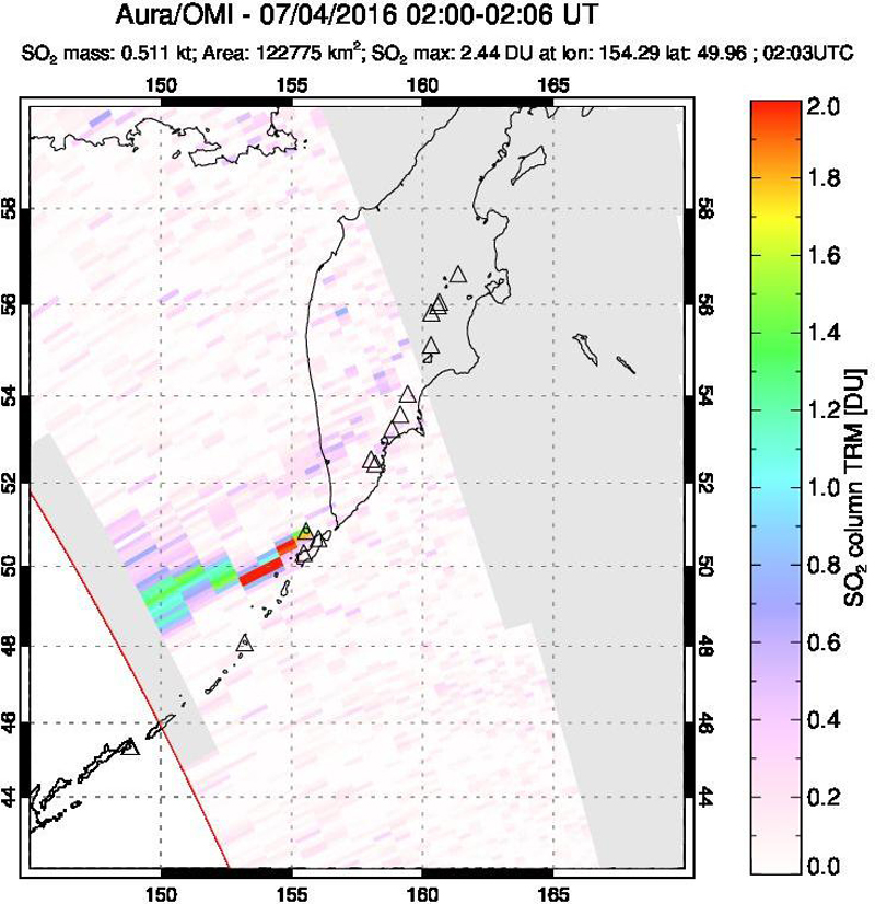 |
Figure 6. SO2 plume drifting SW from Alaid captured on 4 July 2016 by the Aura instrument on the OMI satellite. Courtesy NASA/GSFC. |
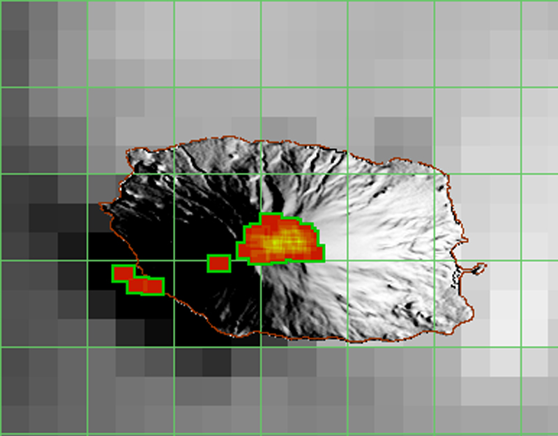 |
Figure 7. MODVOLC thermal alert pixel data for Alaid during 3-7 July 2016 showing a multi-pixel alert at the summit likely from Strombolian activity and alert pixels on the SW flank described by KVERT as a lava flow. Green grid lines represent 0.05 decimal degrees. Courtesy of MODVOLC. |
The last ash plume was observed by the Tokyo VAAC on 3 July 2016. The final thermal alert was recorded by MODVOLC on 7 July. MIROVA anomalies continued steadily, however, at low levels through the first week in August before ceasing. Two additional MIROVA anomalies appeared briefly in the first and last weeks of September. KVERT reported thermal anomalies continuing until early August. They also noted a gas-and-steam plume extending 155 km NE on 26 July. In their VONA (Volcano Observatory Notice for Aviation) issued on 11 August 2016 at 2305 UTC (1105 on 12 August KST), KVERT lowered the ACC to Yellow based on decreasing intensity of thermal anomalies, and no additional ash plumes since 4 July; they lowered it again to Green on 19 August (local time) citing no further evidence for volcanic activity since the last thermal anomaly on 11 August.
Information Contacts: Kamchatka Volcanic Eruptions Response Team (KVERT), Far East Division, Russian Academy of Sciences, 9 Piip Blvd., Petropavlovsk-Kamchatsky, 683006, Russia (URL: http://www.kscnet.ru/ivs/); Tokyo Volcanic Ash Advisory Center (VAAC), 1-3-4 Otemachi, Chiyoda-ku, Tokyo, Japan (URL: http://ds.data.jma.go.jp/svd/vaac/data/); MIROVA (Middle InfraRed Observation of Volcanic Activity), a collaborative project between the Universities of Turin and Florence (Italy) supported by the Centre for Volcanic Risk of the Italian Civil Protection Department (URL: http://www.mirovaweb.it/); Hawai'i Institute of Geophysics and Planetology (HIGP), MODVOLC Thermal Alerts System, School of Ocean and Earth Science and Technology (SOEST), Univ. of Hawai'i, 2525 Correa Road, Honolulu, HI 96822, USA (URL: http://modis.higp.hawaii.edu/, http://modis.higp.hawaii.edu/); NASA Goddard Space Flight Center (NASA/GSFC), Global Sulfur Dioxide Monitoring Page, Atmospheric Chemistry and Dynamics Laboratory, 8800 Greenbelt Road, Goddard, Maryland, USA (URL: https://so2.gsfc.nasa.gov/).
Small ash plume reported on 21 August 2018
Sporadic ash and gas-and-ash plumes and strong thermal anomalies were reported from Alaid, in Russia's Kurile Islands, between 29 September 2015 and 30 September 2016 (figure 8). The Kamchatka Volcanic Eruptions Response Team (KVERT), which monitors the volcano, interpreted the thermal anomalies as Strombolian activity and a lava flow (BGVN 42:04). The current report summarizes activity during October 2016 through August 2018.
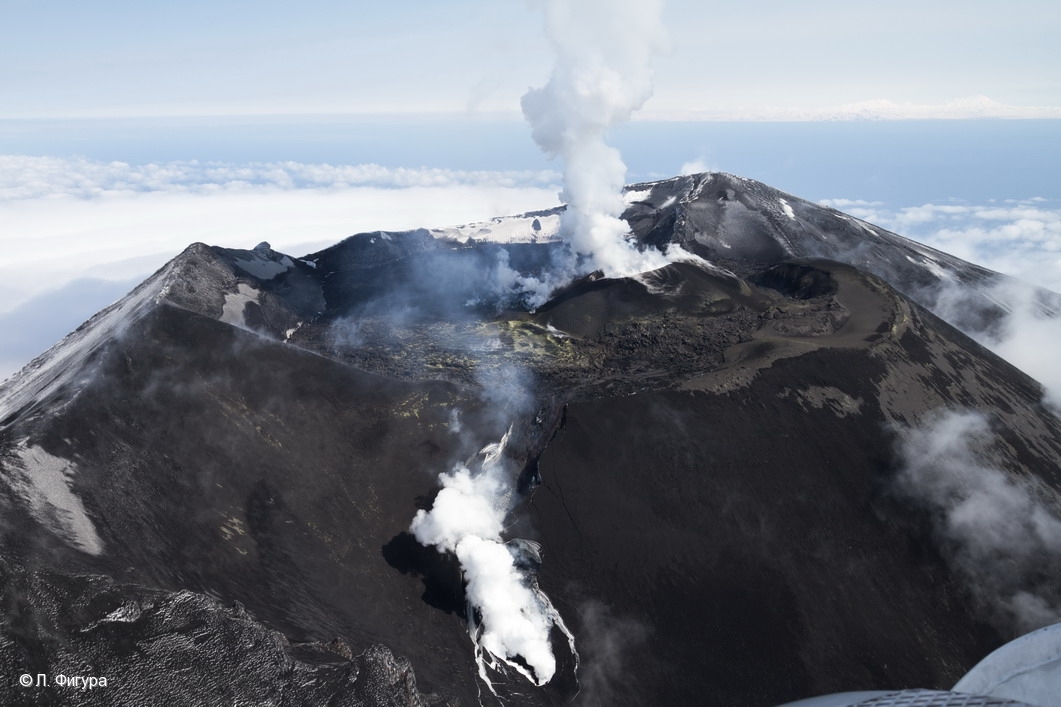 |
Figure 8. Aerial photo of the Alaid summit area on 28 April 2016, with fresh lava filling the crater, a cinder cone in the southern part of the crater, and a lava flow on the SW flank. Photo by L. Fugura; courtesy of IVS FEB RAS, KVERT. |
According to KVERT weekly reports, the Aviation Color Code for Alaid was Green (Volcano is in normal, non-eruptive state) throughout the reporting period. The only reported activity was from the Tokyo Volcanic Ash Advisory Center, which reported that on 21 August 2018, an ash plume identified in Himawari-8 satellite images rose to an altitude of 2.7 km (about 500 m above the summit) and drifted SE. The plume was clearly visible on imagery starting at 0830 Japan Standard Time (UTC + 9 hours), and remained noticeable for at least 4 hours. There were no other satellite or ground-based observations of this activity.
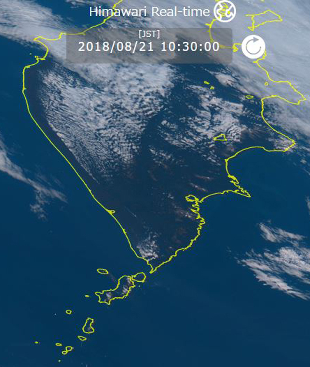 |
Figure 9. Himawari-8 satellite image from 21 August 2018 at 1030 JST (UTC + 9 hours) showing a small ash plume drifting SE from Alaid towards Paramushir Island. Alaid is the small island NW of the larger Paramushi Island and directly W of the southern tip of the Kamchatka Peninsula. Courtesy of Himawari-8 Real-time Web. |
Information Contacts: Tokyo Volcanic Ash Advisory Center (VAAC), 1-3-4 Otemachi, Chiyoda-ku, Tokyo, Japan (URL: http://ds.data.jma.go.jp/svd/vaac/data/); Kamchatka Volcanic Eruptions Response Team (KVERT), Far Eastern Branch, Russian Academy of Sciences, 9 Piip Blvd., Petropavlovsk-Kamchatsky, 683006, Russia (URL: http://www.kscnet.ru/ivs/kvert/); Institute of Volcanology and Seismology, Far Eastern Branch, Russian Academy of Sciences (IVS FEB RAS), 9 Piip Blvd., Petropavlovsk-Kamchatsky 683006, Russia (URL: http://www.kscnet.ru/ivs/eng/); Himawari-8 Real-time Web, developed by the NICT Science Cloud project in NICT (National Institute of Information and Communications Technology), Japan, in collaboration with JMA (Japan Meteorological Agency) and CEReS (Center of Environmental Remote Sensing, Chiba University) (URL: https://himawari8.nict.go.jp/).
Explosions, ash plumes, and lava effusion during September-November 2022
Alaid, the northernmost volcano in the Kuril Islands, has a 1.5-km-wide summit crater that is open to the S. Strong explosive eruptions have occurred from the summit crater beginning in the 18th century; explosive eruptions during 1790 and 1981 were among the largest reported in the Kuril Islands. The last eruption, during August 2018, was characterized by a small ash plume (BGVN 43:09). This report reviews a new eruption during 10 September through 26 November 2022 that consisted of Strombolian explosions, intermittent ash plumes, and lava effusion, based on weekly and daily reports from the Kamchatka Volcano Eruptions Response Team (KVERT), Tokyo VAAC (Volcanic Ash Advisory Center), and satellite data.
Strong thermal activity was detected at or near the summit during mid-September through late November 2022. According to the MODVOLC Thermal Alerts System, there were 91 hotspots detected during 1-10, 13-16, 22-23, and 25-26 October, and 25-27 November. These dates of stronger thermal anomalies were also detected in the MIROVA (Middle InfraRed Observation of Volcanic Activity) volcano hotspot detection system, which was due to the emergence of an active lava flow on the S flank (figure 10).
|
Figure 10. Strong thermal anomalies were detected at Alaid beginning in mid-September and continued through late November 2022, according to this MIROVA graph (Log Radiative Power). The peak of these anomalies coincides with the time during which an active lava flow was observed descending the S flank. After strong explosive activity during October, the temperature of the thermal activity gradually began to decrease in early November, though anomalies continued to be detected. The later spike in activity toward the end of November correlates with explosive activity that generated ash plumes. Courtesy of MIROVA. |
An ash plume detected in HIMAWARI-8 satellite imagery on 10 September rose to 3 km altitude (about 700 m above the summit at 2,285 m) and drifted SE, according to the Tokyo VAAC. KVERT reported that a strong thermal anomaly was detected over the volcano at 1139 on 15 September, which was considered the beginning of a Strombolian explosive eruption. A VONA (Volcano Observatory Notice for Aviation) issued on 18 September reported a gas-and-steam plume containing some ash that rose to 2.6 km altitude and drifted 32-50 km ESE, based on satellite images (figure 11). On 21 September ash plumes rose to 2.7 km altitude and drifted E and NE, based on a report from the Tokyo VAAC. During 26-27 September ash plumes rose to 3 km altitude and drifted 65-140 km ESE, NE, SE, and E. According to KVERT, a lava flow began to effuse on the S flank during 27-28 September; that flow remained active through at least 26 November, based on clear weather Sentinel-2 infrared images (figure 12).
|
Figure 11. Photo of the explosive Strombolian eruption at Alaid on 18 September 2022 with a dark gray ash plume rising about 300 m above the summit and drifting E and NE. Courtesy of A. Yakimova, KVERT. |
|
Figure 12. Sentinel-2 infrared satellite imagery showing a strong thermal anomaly at the summit crater of Alaid on 27 September (top left), 4 October (top right), 24 October (bottom left), and 26 November 2022 (bottom right). An active lava flow was also visible on the S flank during the latter three dates, accompanied by strong gas-and-ash plumes. Images with “Atmospheric penetration” (bands 12, 11, 8A) rendering. Courtesy of Sentinel Hub Playground. |
Strong thermal activity, intermittent explosions, and ash plumes were reported during October. An intense thermal anomaly was observed during 13-16 and 20 October when weather did not obscure the views. On 14 October ash plumes rose to 3.5 km altitude and drifted 32-343 km E and ESE. Explosive activity increased on 15 October, when ash plumes rose to 5-6.5 km altitude (4.3 km above the summit) and drifted 152-360 km E and ESE. On 16 October ash plumes rose to 3-3.7 km altitude and drifted 145-293 km ESE. Explosions on 24 October produced an ash plume that rose to 3.5 km altitude and extended 72-460 km ENE. On 26 October an ash plume rose to 3 km altitude and drifted 60-700 km E. Satellite data showed that the temperature of thermal activity began to decrease on 29 October.
During November, activity continued to gradually decrease, according to KVERT. Thermal anomalies continued to be detected occasionally throughout the month. Satellite images captured at 1025 on 26 November showed ash plumes from explosions rising to 4.5-4.7 km altitude and drifting 38 km SE. Explosions continued throughout the day; at 1521 ash plumes had risen to 3.5 km altitude and drifted as far as 220 km SE. Ground observations showed a small ash plume coming from the crater, ash deposits, and a plume rising from the S flank where the lava flow was likely contacting snow (figure 13). According to KVERT, no further ash emissions were detected after 26 November and the temperature of the thermal anomaly had decreased to background levels by 1 December.
|
Figure 13. Photo of an eruption at Alaid with a small ash plume rising from the summit crater and a lava flow on the S flank on 26 November 2022. Ash deposits are visible on the snow and a larger plume from the end of the lava flow is likely due to interaction with snow. Photo has been color corrected. Courtesy of S. Lakomov, KVERT. |
Information Contacts: Kamchatka Volcanic Eruptions Response Team (KVERT), Far Eastern Branch, Russian Academy of Sciences, 9 Piip Blvd., Petropavlovsk-Kamchatsky, 683006, Russia (URL: http://www.kscnet.ru/ivs/kvert/); Tokyo Volcanic Ash Advisory Center (VAAC), 1-3-4 Otemachi, Chiyoda-ku, Tokyo 100-8122, Japan (URL: http://ds.data.jma.go.jp/svd/vaac/data/); MIROVA (Middle InfraRed Observation of Volcanic Activity), a collaborative project between the Universities of Turin and Florence (Italy) supported by the Centre for Volcanic Risk of the Italian Civil Protection Department (URL: http://www.mirovaweb.it/); Hawai'i Institute of Geophysics and Planetology (HIGP) - MODVOLC Thermal Alerts System, School of Ocean and Earth Science and Technology (SOEST), Univ. of Hawai'i, 2525 Correa Road, Honolulu, HI 96822, USA (URL: http://modis.higp.hawaii.edu/); Sentinel Hub Playground (URL: https://www.sentinel-hub.com/explore/sentinel-playground).
|
|
||||||||||||||||||||||||||
There is data available for 15 confirmed eruptive periods.
2022 Sep 10 - 2022 Nov 26 Confirmed Eruption (Explosive / Effusive) VEI: 2
| Episode 1 | Eruption (Explosive / Effusive) | ||||||||||||||||||||||||
|---|---|---|---|---|---|---|---|---|---|---|---|---|---|---|---|---|---|---|---|---|---|---|---|---|
| 2022 Sep 10 - 2022 Nov 26 | Evidence from Observations: Reported | |||||||||||||||||||||||
|
List of 3 Events for Episode 1
|
||||||||||||||||||||||||
2018 Aug 21 - 2018 Aug 21 Confirmed Eruption (Explosive / Effusive) VEI: 1
| Episode 1 | Eruption (Explosive / Effusive) | Summit crater | ||||||||||||||||||
|---|---|---|---|---|---|---|---|---|---|---|---|---|---|---|---|---|---|---|---|
| 2018 Aug 21 - 2018 Aug 21 | Evidence from Observations: Satellite (visual) | ||||||||||||||||||
|
List of 2 Events for Episode 1 at Summit crater
|
|||||||||||||||||||
2015 Sep 29 - 2016 Aug 11 Confirmed Eruption (Explosive / Effusive) VEI: 2
| Episode 1 | Eruption (Explosive / Effusive) | Summit crater | |||||||||||||||||||||||||||||||||||||||||||||||||||||||||||||||||||||||||||||||||||||||||||||||||||||||
|---|---|---|---|---|---|---|---|---|---|---|---|---|---|---|---|---|---|---|---|---|---|---|---|---|---|---|---|---|---|---|---|---|---|---|---|---|---|---|---|---|---|---|---|---|---|---|---|---|---|---|---|---|---|---|---|---|---|---|---|---|---|---|---|---|---|---|---|---|---|---|---|---|---|---|---|---|---|---|---|---|---|---|---|---|---|---|---|---|---|---|---|---|---|---|---|---|---|---|---|---|---|---|---|---|
| 2015 Sep 29 - 2016 Jan 4 | Evidence from Observations: Reported | |||||||||||||||||||||||||||||||||||||||||||||||||||||||||||||||||||||||||||||||||||||||||||||||||||||||
|
List of 19 Events for Episode 1 at Summit crater
|
||||||||||||||||||||||||||||||||||||||||||||||||||||||||||||||||||||||||||||||||||||||||||||||||||||||||
| Episode 2 | Eruption (Explosive / Effusive) | Summit crater and SW flank | |||||||||||||||||||||||||||||||||||||||||||||||||||||||||||||||||||||||||||||||||||||||||||||||||||||||||||||||||||||||||||||||||||||||||||||||||||||||||||||||||||||||||||||||||||||||||||||||||||||||||||
|---|---|---|---|---|---|---|---|---|---|---|---|---|---|---|---|---|---|---|---|---|---|---|---|---|---|---|---|---|---|---|---|---|---|---|---|---|---|---|---|---|---|---|---|---|---|---|---|---|---|---|---|---|---|---|---|---|---|---|---|---|---|---|---|---|---|---|---|---|---|---|---|---|---|---|---|---|---|---|---|---|---|---|---|---|---|---|---|---|---|---|---|---|---|---|---|---|---|---|---|---|---|---|---|---|---|---|---|---|---|---|---|---|---|---|---|---|---|---|---|---|---|---|---|---|---|---|---|---|---|---|---|---|---|---|---|---|---|---|---|---|---|---|---|---|---|---|---|---|---|---|---|---|---|---|---|---|---|---|---|---|---|---|---|---|---|---|---|---|---|---|---|---|---|---|---|---|---|---|---|---|---|---|---|---|---|---|---|---|---|---|---|---|---|---|---|---|---|---|---|---|---|---|---|---|
| 2016 Feb 20 - 2016 Aug 11 | Evidence from Observations: Reported | |||||||||||||||||||||||||||||||||||||||||||||||||||||||||||||||||||||||||||||||||||||||||||||||||||||||||||||||||||||||||||||||||||||||||||||||||||||||||||||||||||||||||||||||||||||||||||||||||||||||||||
|
List of 39 Events for Episode 2 at Summit crater and SW flank
|
||||||||||||||||||||||||||||||||||||||||||||||||||||||||||||||||||||||||||||||||||||||||||||||||||||||||||||||||||||||||||||||||||||||||||||||||||||||||||||||||||||||||||||||||||||||||||||||||||||||||||||
2012 Oct 5 - 2012 Dec 12 Confirmed Eruption (Explosive / Effusive) VEI: 2
| Episode 1 | Eruption (Explosive / Effusive) | Summit crater | ||||||||||||||||||||||||||||||||||||||||||||||||||||||||||||||||||||||||||||||||||||||||||||||||||
|---|---|---|---|---|---|---|---|---|---|---|---|---|---|---|---|---|---|---|---|---|---|---|---|---|---|---|---|---|---|---|---|---|---|---|---|---|---|---|---|---|---|---|---|---|---|---|---|---|---|---|---|---|---|---|---|---|---|---|---|---|---|---|---|---|---|---|---|---|---|---|---|---|---|---|---|---|---|---|---|---|---|---|---|---|---|---|---|---|---|---|---|---|---|---|---|---|---|---|---|
| 2012 Oct 5 - 2012 Dec 12 | Evidence from Observations: Reported | ||||||||||||||||||||||||||||||||||||||||||||||||||||||||||||||||||||||||||||||||||||||||||||||||||
|
List of 18 Events for Episode 1 at Summit crater
|
|||||||||||||||||||||||||||||||||||||||||||||||||||||||||||||||||||||||||||||||||||||||||||||||||||
[ 1997 Aug 23 - 1997 Aug 23 ] Uncertain Eruption
| Episode 1 | Eruption (Explosive / Effusive) | ||||||||||||||
|---|---|---|---|---|---|---|---|---|---|---|---|---|---|---|
| 1997 Aug 23 - 1997 Aug 23 | Evidence from Unknown | |||||||||||||
|
List of 1 Events for Episode 1
|
||||||||||||||
1996 Dec 3 Confirmed Eruption (Explosive / Effusive) VEI: 2
| Episode 1 | Eruption (Explosive / Effusive) | |||||||||||||||||||||||||||||
|---|---|---|---|---|---|---|---|---|---|---|---|---|---|---|---|---|---|---|---|---|---|---|---|---|---|---|---|---|---|
| 1996 Dec 3 - Unknown | Evidence from Observations: Reported | ||||||||||||||||||||||||||||
|
List of 4 Events for Episode 1
|
|||||||||||||||||||||||||||||
1986 May 25 - 1986 May 28 ± 3 days Confirmed Eruption (Explosive / Effusive) VEI: 2 (?)
| Episode 1 | Eruption (Explosive / Effusive) | ||||||||||||||||||||||||||||||||||
|---|---|---|---|---|---|---|---|---|---|---|---|---|---|---|---|---|---|---|---|---|---|---|---|---|---|---|---|---|---|---|---|---|---|---|
| 1986 May 25 - 1986 May 28 ± 3 days | Evidence from Observations: Reported | |||||||||||||||||||||||||||||||||
|
List of 5 Events for Episode 1
|
||||||||||||||||||||||||||||||||||
1982 Mar 29 - 1982 Mar 29 Confirmed Eruption (Explosive / Effusive) VEI: 2
| Episode 1 | Eruption (Explosive / Effusive) | ||||||||||||||||||||||||
|---|---|---|---|---|---|---|---|---|---|---|---|---|---|---|---|---|---|---|---|---|---|---|---|---|
| 1982 Mar 29 - 1982 Mar 29 | Evidence from Observations: Reported | |||||||||||||||||||||||
|
List of 3 Events for Episode 1
|
||||||||||||||||||||||||
1981 Nov 25 Confirmed Eruption (Explosive / Effusive) VEI: 2
| Episode 1 | Eruption (Explosive / Effusive) | ||||||||||||||||||||||||
|---|---|---|---|---|---|---|---|---|---|---|---|---|---|---|---|---|---|---|---|---|---|---|---|---|
| 1981 Nov 25 - Unknown | Evidence from Observations: Reported | |||||||||||||||||||||||
|
List of 3 Events for Episode 1
|
||||||||||||||||||||||||
1981 Apr 27 - 1981 Jun 5 Confirmed Eruption (Explosive / Effusive) VEI: 4
| Episode 1 | Eruption (Explosive / Effusive) | ||||||||||||||||||||||||||||||||||||||||||||||||||||||||||||||||||||||||||
|---|---|---|---|---|---|---|---|---|---|---|---|---|---|---|---|---|---|---|---|---|---|---|---|---|---|---|---|---|---|---|---|---|---|---|---|---|---|---|---|---|---|---|---|---|---|---|---|---|---|---|---|---|---|---|---|---|---|---|---|---|---|---|---|---|---|---|---|---|---|---|---|---|---|---|
| 1981 Apr 27 - 1981 Jun 5 | Evidence from Observations: Reported | |||||||||||||||||||||||||||||||||||||||||||||||||||||||||||||||||||||||||
|
List of 13 Events for Episode 1
|
||||||||||||||||||||||||||||||||||||||||||||||||||||||||||||||||||||||||||
[ 1973 Jul 2 ± 182 days ] Uncertain Eruption
| Episode 1 | Eruption (Explosive / Effusive) | ||||||||||||||
|---|---|---|---|---|---|---|---|---|---|---|---|---|---|---|
| 1973 Jul 2 ± 182 days - Unknown | Evidence from Unknown | |||||||||||||
|
List of 1 Events for Episode 1
|
||||||||||||||
1972 Jun 18 - 1972 Sep 11 Confirmed Eruption (Explosive / Effusive) VEI: 3
| Episode 1 | Eruption (Explosive / Effusive) | NW foot | |||||||||||||||||||||||||||||||||||||||||||||||||||||||||||||||
|---|---|---|---|---|---|---|---|---|---|---|---|---|---|---|---|---|---|---|---|---|---|---|---|---|---|---|---|---|---|---|---|---|---|---|---|---|---|---|---|---|---|---|---|---|---|---|---|---|---|---|---|---|---|---|---|---|---|---|---|---|---|---|---|---|
| 1972 Jun 18 - 1972 Sep 11 | Evidence from Observations: Reported | |||||||||||||||||||||||||||||||||||||||||||||||||||||||||||||||
|
List of 11 Events for Episode 1 at NW foot
|
||||||||||||||||||||||||||||||||||||||||||||||||||||||||||||||||
1933 Nov 13 - 1934 Aug Confirmed Eruption (Explosive / Effusive) VEI: 2
| Episode 1 | Eruption (Explosive / Effusive) | East submarine flank (Taketomi) | ||||||||||||||||||||||||||||||||||||||||||||||||
|---|---|---|---|---|---|---|---|---|---|---|---|---|---|---|---|---|---|---|---|---|---|---|---|---|---|---|---|---|---|---|---|---|---|---|---|---|---|---|---|---|---|---|---|---|---|---|---|---|---|
| 1933 Nov 13 - 1934 Aug | Evidence from Observations: Reported | ||||||||||||||||||||||||||||||||||||||||||||||||
|
List of 8 Events for Episode 1 at East submarine flank (Taketomi)
|
|||||||||||||||||||||||||||||||||||||||||||||||||
1894 Confirmed Eruption (Explosive / Effusive) VEI: 2
| Episode 1 | Eruption (Explosive / Effusive) | |||||||||||||||||||
|---|---|---|---|---|---|---|---|---|---|---|---|---|---|---|---|---|---|---|---|
| 1894 - Unknown | Evidence from Observations: Reported | ||||||||||||||||||
|
List of 2 Events for Episode 1
|
|||||||||||||||||||
1860 Jul 7 - 1860 Jul 9 Confirmed Eruption (Explosive / Effusive) VEI: 3
| Episode 1 | Eruption (Explosive / Effusive) | ||||||||||||||||||||||||
|---|---|---|---|---|---|---|---|---|---|---|---|---|---|---|---|---|---|---|---|---|---|---|---|---|
| 1860 Jul 7 - 1860 Jul 9 | Evidence from Observations: Reported | |||||||||||||||||||||||
|
List of 3 Events for Episode 1
|
||||||||||||||||||||||||
1854 Jun 27 Confirmed Eruption (Explosive / Effusive) VEI: 3
| Episode 1 | Eruption (Explosive / Effusive) | |||||||||||||||||||
|---|---|---|---|---|---|---|---|---|---|---|---|---|---|---|---|---|---|---|---|
| 1854 Jun 27 - Unknown | Evidence from Observations: Reported | ||||||||||||||||||
|
List of 2 Events for Episode 1
|
|||||||||||||||||||
1790 - 1793 Confirmed Eruption (Explosive / Effusive) VEI: 4
| Episode 1 | Eruption (Explosive / Effusive) | |||||||||||||||||||||||||||||
|---|---|---|---|---|---|---|---|---|---|---|---|---|---|---|---|---|---|---|---|---|---|---|---|---|---|---|---|---|---|
| 1790 - 1793 | Evidence from Observations: Reported | ||||||||||||||||||||||||||||
| Beginning in 1790 "vapors" with ash started to be emitted at varying intervals, and in February 1793 it was in a state of violent eruption (Gorshkov, 1970). | |||||||||||||||||||||||||||||
|
List of 4 Events for Episode 1
|
|||||||||||||||||||||||||||||
This compilation of synonyms and subsidiary features may not be comprehensive. Features are organized into four major categories: Cones, Craters, Domes, and Thermal Features. Synonyms of features appear indented below the primary name. In some cases additional feature type, elevation, or location details are provided.
Synonyms |
||||
| Oiakoba | Uyakuzhach | Araito | Araito-Fuji | Chachanupuri | Oyakoba-yama | Oyakobatska | ||||
Cones |
||||
| Feature Name | Feature Type | Elevation | Latitude | Longitude |
| Osobaya Peak | Cone | 184 m | 50° 49' 30.00" N | 155° 38' 14.00" E |
| Parazit | Cone | 1023 m | ||
Craters |
||||
| Feature Name | Feature Type | Elevation | Latitude | Longitude |
| Taketomi | Crater | |||
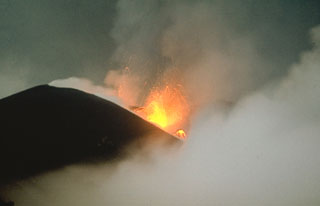 Strombolian eruptions occurred at vents along a 2-km-long fissure on the NW flank of Alaid in 1972. Explosive activity began on 18 June and was accompanied by lava extrusion beginning on the 21st. By 16 July lava flows dominated the activity, extending 1 km to the sea and forming a new peninsula. Explosive activity diminished prior to the end of the eruption on 11 September.
 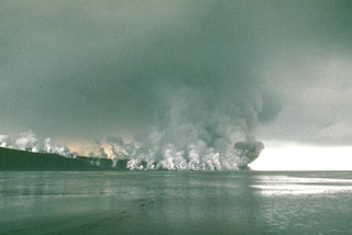 Gas-and-steam plumes rise above a lava flow advancing into the Sea of Okhotsk on the NW flank of Alaid in 1972. The flow erupted from NW-flank fissures and traveled 1 km and, creating a new 1 km2 peninsula. The eruption began with explosive activity from a 2-km-long fissure on 18 June 1972 and transitioned to lava flow extrusion beginning 21 June.
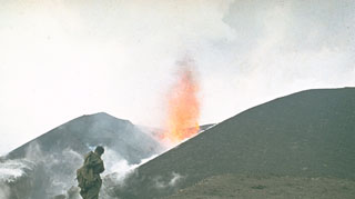 A volcanologist from the Institute of Volcanology in Petropavlovsk observes a lava fountain at an Alaid scoria cone in 1972. The eruption began on 18 June and lasted until 11 September. A chain of small cones formed on a 2-km-long fissure on the lower NW flank and lava flows reached the sea, forming a new peninsula.
 An ash plume rises above Alaid on 30 April 1981, at the peak of an eruption that began on 27 April (seen here from the N). The plume extended 2,000 km to the SE. The volcano has a 1.5-km-wide summit crater and numerous cones across the lower flanks. Explosive eruptions in 1790 and 1981 were among the largest in the Kuril Islands.
 The 1972 eruption of Alaid in the northern Kuril Islands, seen here in August, was characterized by both explosive and effusive activity. An ash plume towers above a small scoria cone that formed on a 2-km-long fissure on the NW flank, while white gas-and-steam plumes rise from the margins of this lava flow that traveled 1 km into the Sea of Okhotsk. The eruption began on 18 June and ended by 11 September.
The following 3 samples associated with this volcano can be found in the Smithsonian's NMNH Department of Mineral Sciences collections, and may be availble for research (contact the Rock and Ore Collections Manager). Catalog number links will open a window with more information.
| Catalog Number | Sample Description | Lava Source | Collection Date |
|---|---|---|---|
| NMNH 116543-10 | Basalt | -- | -- |
| NMNH 116543-9 | Basalt | -- | -- |
| NMNH 116556-85 | Basalt | -- | -- |
| Copernicus Browser | The Copernicus Browser replaced the Sentinel Hub Playground browser in 2023, to provide access to Earth observation archives from the Copernicus Data Space Ecosystem, the main distribution platform for data from the EU Copernicus missions. |
| MIROVA | Middle InfraRed Observation of Volcanic Activity (MIROVA) is a near real time volcanic hot-spot detection system based on the analysis of MODIS (Moderate Resolution Imaging Spectroradiometer) data. In particular, MIROVA uses the Middle InfraRed Radiation (MIR), measured over target volcanoes, in order to detect, locate and measure the heat radiation sourced from volcanic activity. |
| MODVOLC Thermal Alerts | Using infrared satellite Moderate Resolution Imaging Spectroradiometer (MODIS) data, scientists at the Hawai'i Institute of Geophysics and Planetology, University of Hawai'i, developed an automated system called MODVOLC to map thermal hot-spots in near real time. For each MODIS image, the algorithm automatically scans each 1 km pixel within it to check for high-temperature hot-spots. When one is found the date, time, location, and intensity are recorded. MODIS looks at every square km of the Earth every 48 hours, once during the day and once during the night, and the presence of two MODIS sensors in space allows at least four hot-spot observations every two days. Each day updated global maps are compiled to display the locations of all hot spots detected in the previous 24 hours. There is a drop-down list with volcano names which allow users to 'zoom-in' and examine the distribution of hot-spots at a variety of spatial scales. |
|
WOVOdat
Single Volcano View Temporal Evolution of Unrest Side by Side Volcanoes |
WOVOdat is a database of volcanic unrest; instrumentally and visually recorded changes in seismicity, ground deformation, gas emission, and other parameters from their normal baselines. It is sponsored by the World Organization of Volcano Observatories (WOVO) and presently hosted at the Earth Observatory of Singapore.
GVMID Data on Volcano Monitoring Infrastructure The Global Volcano Monitoring Infrastructure Database GVMID, is aimed at documenting and improving capabilities of volcano monitoring from the ground and space. GVMID should provide a snapshot and baseline view of the techniques and instrumentation that are in place at various volcanoes, which can be use by volcano observatories as reference to setup new monitoring system or improving networks at a specific volcano. These data will allow identification of what monitoring gaps exist, which can be then targeted by remote sensing infrastructure and future instrument deployments. |
| Volcanic Hazard Maps | The IAVCEI Commission on Volcanic Hazards and Risk has a Volcanic Hazard Maps database designed to serve as a resource for hazard mappers (or other interested parties) to explore how common issues in hazard map development have been addressed at different volcanoes, in different countries, for different hazards, and for different intended audiences. In addition to the comprehensive, searchable Volcanic Hazard Maps Database, this website contains information about diversity of volcanic hazard maps, illustrated using examples from the database. This site is for educational purposes related to volcanic hazard maps. Hazard maps found on this website should not be used for emergency purposes. For the most recent, official hazard map for a particular volcano, please seek out the proper institutional authorities on the matter. |
| IRIS seismic stations/networks | Incorporated Research Institutions for Seismology (IRIS) Data Services map showing the location of seismic stations from all available networks (permanent or temporary) within a radius of 0.18° (about 20 km at mid-latitudes) from the given location of Alaid. Users can customize a variety of filters and options in the left panel. Note that if there are no stations are known the map will default to show the entire world with a "No data matched request" error notice. |
| UNAVCO GPS/GNSS stations | Geodetic Data Services map from UNAVCO showing the location of GPS/GNSS stations from all available networks (permanent or temporary) within a radius of 20 km from the given location of Alaid. Users can customize the data search based on station or network names, location, and time window. Requires Adobe Flash Player. |
| DECADE Data | The DECADE portal, still in the developmental stage, serves as an example of the proposed interoperability between The Smithsonian Institution's Global Volcanism Program, the Mapping Gas Emissions (MaGa) Database, and the EarthChem Geochemical Portal. The Deep Earth Carbon Degassing (DECADE) initiative seeks to use new and established technologies to determine accurate global fluxes of volcanic CO2 to the atmosphere, but installing CO2 monitoring networks on 20 of the world's 150 most actively degassing volcanoes. The group uses related laboratory-based studies (direct gas sampling and analysis, melt inclusions) to provide new data for direct degassing of deep earth carbon to the atmosphere. |
| Large Eruptions of Alaid | Information about large Quaternary eruptions (VEI >= 4) is cataloged in the Large Magnitude Explosive Volcanic Eruptions (LaMEVE) database of the Volcano Global Risk Identification and Analysis Project (VOGRIPA). |
| EarthChem | EarthChem develops and maintains databases, software, and services that support the preservation, discovery, access and analysis of geochemical data, and facilitate their integration with the broad array of other available earth science parameters. EarthChem is operated by a joint team of disciplinary scientists, data scientists, data managers and information technology developers who are part of the NSF-funded data facility Integrated Earth Data Applications (IEDA). IEDA is a collaborative effort of EarthChem and the Marine Geoscience Data System (MGDS). |

