Fumarole temperatures decrease
Geologists visited Ahuan fumarole on 23 November. The fumarole temperature was 305°C, a decrease from 336°C measured in May 1988.
Information Contacts: Kurt Roggensack, Helen Mango, John Lucio, and Half Zantop, Dartmouth College.
The Global Volcanism Program has no Weekly Reports available for Michoacán-Guanajuato.
Reports are organized chronologically and indexed below by Month/Year (Publication Volume:Number), and include a one-line summary. Click on the index link or scroll down to read the reports.
Fumaroles emit acid gases
"Fumaroles at several localities were emitting small amounts of acid gases but there was no visible plume at the summit or elsewhere when visited 28 April-1 May. Temperatures were mostly less than 150°C but some were much hotter, over 400°C."
Information Contacts: R. Stoiber, L. Benton, C. Connor, D. Douglass, D. Shumway, and J. Swartz, Dartmouth College.
Fumarole temperatures increase
"Fumarolic activity persisted at Ahuan vent on the SW flank. When temperatures were measured at Ahuan vent on 29 November, the hottest fumarole was 473°C, 70° higher than in April 1983, when Dartmouth scientists last measured temperatures at Parícutin. Several fumaroles over an area of about 50 m2 were hotter than 300°C. No physical changes in the area were apparent since April 1983."
Information Contacts: C. Connor, B. Gemmell, and R. Stoiber, Dartmouth College.
Temperature of hottest fumarole declines; HCl-rich gases
When geologists visited Parícutin 26 November, fumaroles were emitting HCl-dominated gases. The temperature of Ahuan fumarole (on the SW flank) was 375°C, about 100° lower than in November 1985. Other fumaroles remained at about 100°C. No other changes were observed.
Information Contacts: R. Stoiber, C. Connor, and other geologists, Dartmouth College.
Fumarole temperatures decline
Geologists mapped fumaroles and measured temperatures on 8 and 16 May. As in previous years, fumaroles were hottest at Ahuan vent (figure 1) but had cooled to 336°C, from 473° in November 1985 and 375° in November 1986. The area seemed morphologically unchanged since April 1983. Fumaroles at Sapichu vent ranged from 186° to 275°C, an increase of as much as 120° since they were last measured in April 1983. Sulfur continued to be deposited around the Sapichu fumaroles. All other fumaroles at Parícutin had temperatures of
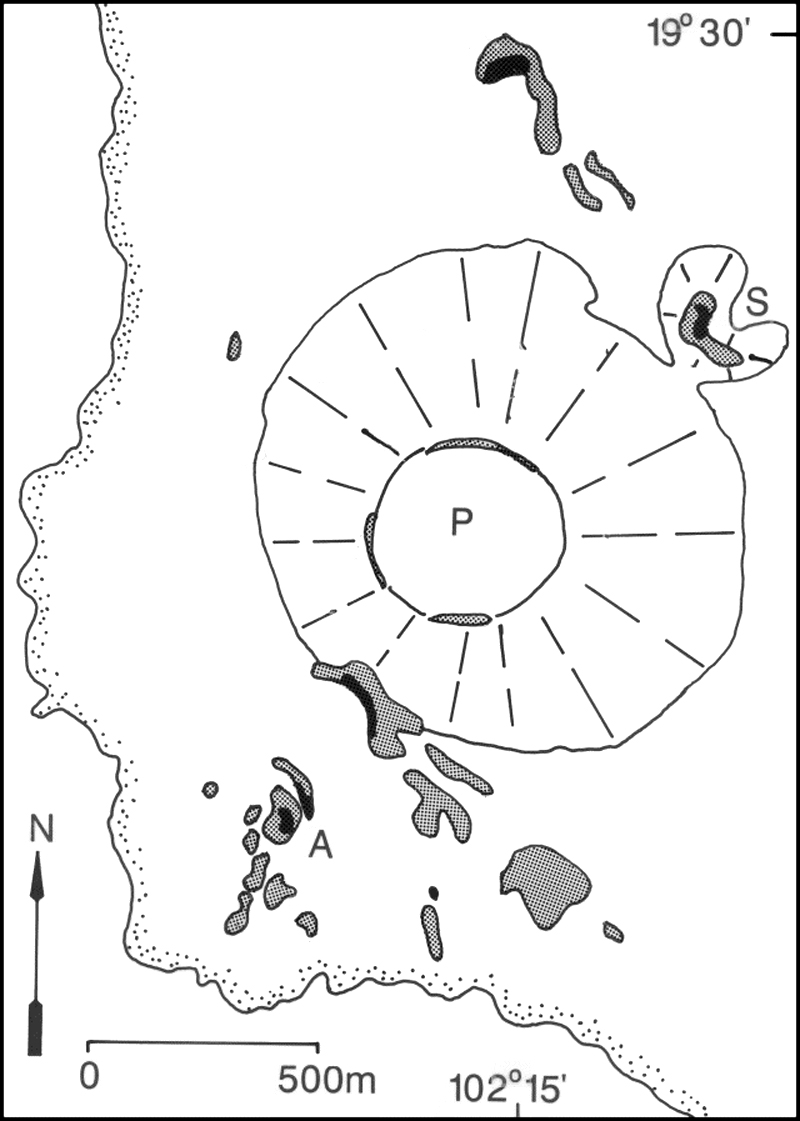 |
Figure 1. Distribution of fumaroles at Parícutin, May 1988. Fumaroles were found in the shaded areas (stipple pattern,100°C). Three vents are labeled: Ahuan (A), the main crater (P), and Sapichu (S). The W and SW margins of lava flows surrounding the cone are indicated by the stippled border. |
Information Contacts: C. Connor, James Diaz, and Jorge Corrales, FIU, Miami; Ana Lillian Martin-Del Pozzo, Instituto de Geofísica, UNAM, México.
Fumarole temperatures decrease
Geologists visited Ahuan fumarole on 23 November. The fumarole temperature was 305°C, a decrease from 336°C measured in May 1988.
Information Contacts: Kurt Roggensack, Helen Mango, John Lucio, and Half Zantop, Dartmouth College.
This compilation of synonyms and subsidiary features may not be comprehensive. Features are organized into four major categories: Cones, Craters, Domes, and Thermal Features. Synonyms of features appear indented below the primary name. In some cases additional feature type, elevation, or location details are provided.
Synonyms |
||||
| Malpais | Tarascan Volcanic Field | ||||
Cones |
||||
| Feature Name | Feature Type | Elevation | Latitude | Longitude |
| Aguila, Cerro la | Stratovolcano | |||
| Aire, Cerro del | Pyroclastic cone | 19° 31' 13" N | 102° 3' 52" W | |
| Alto, Cerro | Shield volcano | 19° 59' 18" N | 102° 30' 34" W | |
| Anillo, Cerro del | Pyroclastic cone | |||
| Arena, Cerro | Pyroclastic cone | 2640 m | 19° 46' 40" N | 101° 54' 31" W |
| Astillero, Cerro el | Pyroclastic cone | 2231 m | 19° 18' 34" N | 102° 22' 58" W |
| Batea, La | Cone | 1938 m | 20° 22' 27" N | 101° 13' 58" W |
| Blanco, Cerro | Shield volcano | 19° 13' 59" N | 102° 27' 53" W | |
| Borrego, Cerro el | Pyroclastic cone | 19° 28' 40" N | 101° 42' 11" W | |
| Brinco del Diablo, Cerro | Shield volcano | 19° 56' 21" N | 101° 43' 55" W | |
| Buenavista Tomatlan, Cerro | Shield volcano | 19° 9' 22" W | 102° 36' 31" W | |
| Cabras, Cerro las | Pyroclastic cone | 19° 49' 34" N | 101° 53' 38" W | |
| Camataran, Cerro | Shield volcano | 20° 10' 37" N | 101° 33' 30" W | |
| Capacuaro, Cerros de | Shield volcano | |||
| Capatacutiro, Cerro de | Pyroclastic cone | |||
| Capaxtiro, Cerro | Shield volcano | |||
| Caracol, Cerro el | Pyroclastic cone | |||
| Catacu, Cerro | Pyroclastic cone | |||
| Cheringerán, Cerro de | Pyroclastic cone | 2120 m | 19° 27' 0" N | 102° 5' 0" W |
| Chino, Cerro del | Pyroclastic cone | 2100 m | 19° 25' 0" N | 102° 6' 30" W |
| Cópitiro, Cerro de | Pyroclastic cone | 2180 m | 19° 29' 7" N | 102° 3' 3" W |
| Cuates, Cerros | Shield volcano | |||
| Cucundicata, Cerro | Pyroclastic cone | |||
| Culiacán, Cerro | Shield volcano | 20° 20' 16" N | 100° 58' 11" W | |
| Curitzerán, Cerro de | Pyroclastic cone | |||
| Cutzato, Cerro de | Pyroclastic cone | 19° 30' 0" N | 102° 11' 0" W | |
| Fresno, Cerro | Shield volcano | |||
| Gato, Cerro | Pyroclastic cone | |||
| Grande la Piedad, Cerro | Shield volcano | 20° 18' 10" N | 102° 7' 1" W | |
| Grande, Cerro | Shield volcano | 20° 24' 28" N | 100° 52' 44" W | |
| Grande, Cerro | Pyroclastic cone | |||
| Grande, Volcán | Stratovolcano | |||
| Hoyo el Huanillo | Pyroclastic cone | 19° 41' 2" N | 101° 59' 6" W | |
| Huanchángueran, Cerro de | Pyroclastic cone | |||
| Jabalí, Cerros del | Pyroclastic cone | 2240 m | 19° 26' 56" N | 102° 6' 40" W |
| Jicalán, Cerro de | Pyroclastic cone | 1840 m | 19° 23' 30" N | 102° 5' 0" W |
| Jorullo | Pyroclastic cone | 1330 m | 18° 58' 19" N | 101° 43' 5" W |
| Laguna, Cerro la | Pyroclastic cone | |||
| Larga, Loma | Pyroclastic cone | |||
| Lobos, Cerro los | Pyroclastic cone | |||
| Melon, Volcan el | Pyroclastic cone | 2647 m | 19° 40' 21" N | 101° 25' 56" W |
| Melón, Volcán el | Pyroclastic cone | |||
| Mesa de Huanárucua | Lava cone | |||
| Mesa de Zirimondiro | Lava cone | |||
|
Metate, Cerro el
Canacuaran |
Shield volcano | 2900 m | 19° 32' 19" N | 101° 59' 33" W |
| Mina, Volcán la | Pyroclastic cone | 19° 42' 47" N | 101° 26' 2" W | |
| Nuevo Juatita | Pyroclastic cone | 2675 m | 19° 29' 44" N | 102° 14' 53" W |
| Nureto, Cerro de | Pyroclastic cone | |||
| Pacaracua, Cerro | Shield volcano | |||
| Pajarito, Cerro | Pyroclastic cone | 3007 m | 19° 45' 7" N | 101° 52' 19" W |
| Paracho, Cerros de | Shield volcano | 19° 35' 21" N | 102° 2' 28" W | |
| Paricutin | Pyroclastic cone | 3170 m | 19° 29' 35" N | 102° 15' 4" W |
|
Pario, Cerro de
Alberca, Cerro de la |
Pyroclastic cone | 2920 m | 19° 28' 0" N | 102° 11' 0" W |
| Patamban, Cerro | Cone | 19° 44' 0" N | 102° 20' 0" W | |
| Pedregal, Cerro el | Pyroclastic cone | 2138 m | 19° 19' 8" N | 102° 21' 5" W |
| Pelón, Cerro | Pyroclastic cone | 19° 17' 53" N | 101° 54' 47" W | |
| Picacho, Cerro el | Shield volcano | |||
| Pilita, Cerro la | Pyroclastic cone | 1096 m | 18° 56' 51" N | 101° 43' 33" W |
| Prieto, Cerro | Shield volcano | |||
| Pueblito, Cerro el | Pyroclastic cone | 19° 49' 30" N | 101° 55' 23" W | |
| Pueblo Viejo, Cerro del | Pyroclastic cone | |||
| Puerto, Cerro del | Pyroclastic cone | 2120 m | 19° 28' 27" N | 102° 2' 6" W |
| Quinceo | Cone | 19° 44' 0" N | 101° 17' 0" W | |
| San Antonio, Cerro | Shield volcano | 19° 22' 32" N | 102° 40' 46" W | |
| San Joaquin Jaripeo | Shield volcano | 19° 51' 0" N | 100° 44' 50" W | |
| Sanambo, Cerro | Shield volcano | 19° 38' 58" N | 101° 26' 32" W | |
| Santa Teresa | Pyroclastic cone | 20° 29' 50" N | 100° 59' 53" W | |
| Santiago Volcanic Field, Valle de | Volcanic field | 20° 23' 0" N | 101° 14' 0" W | |
| Sapien, Cerro | Pyroclastic cone | 2120 m | 19° 27' 0" N | 102° 6' 0" W |
| Sicuín, Cerro de | Pyroclastic cone | |||
| Sosal, Cerro el | Pyroclastic cone | |||
| Surúndaro, Cerro de | Pyroclastic cone | |||
| Tancítaro, Volcán | Stratovolcano | 3842 m | 19° 25' 0" N | 102° 19' 0" W |
| Tarucun, Cerro | Pyroclastic cone | |||
| Taza, Cerro la | Pyroclastic cone | 2340 m | 19° 31' 34" N | 101° 43' 30" W |
| Tecolote, Cerro | Stratovolcano | 3354 m | 19° 46' 31" N | 101° 52' 35" W |
| Tinaja, Cerro la | Pyroclastic cone | |||
| Tule, Cerro el | Shield volcano | |||
| Tzintzungo, Cerro de | Pyroclastic cone | |||
| Yahuarato, Cerro | Shield volcano | 19° 36' 53" N | 101° 33' 6" W | |
| Zacapu, Volcanes de | Cone | 19° 48' 0" N | 101° 48' 0" W | |
| Zoyate, Cerro el | Pyroclastic cone | |||
Craters |
||||
| Feature Name | Feature Type | Elevation | Latitude | Longitude |
| Alberca, Hoya la | Maar | 1672 m | 20° 23' 21" N | 101° 12' 5" W |
| Alvarez | Maar | 2100 m | 20° 19' 30" N | 101° 12' 30" W |
| Blanca | Maar | 1819 m | 20° 22' 39" N | 101° 13' 4" W |
| Costo Maar | Maar | 1920 m | 19° 27' 0" N | 102° 4' 0" W |
| Cotji, Cerro (Costo Maar) | Maar | 1920 m | 19° 27' 0" N | 102° 4' 0" W |
| Culiacán | Maar | |||
|
Hoya de Cintora
Olla de Zintora |
Maar | 1703 m | 20° 21' 23" N | 101° 12' 49" W |
| Hoya Estrada | Maar | 1768 m | 20° 23' 17" N | 101° 13' 37" W |
| Olla de Flores | Maar | |||
| Rincón de Parangüeo | Maar | 2050 m | 20° 26' 0" N | 101° 15' 0" W |
| Rincón, El | Maar | |||
| San Gerónimo | Maar | |||
| San Nicolás | Maar | 1820 m | 20° 23' 17" N | 101° 15' 25" W |
| Santa Rosa | Maar | |||
| Solís | Maar | 1787 m | 20° 21' 59" N | 101° 13' 34" W |
Domes |
||||
| Feature Name | Feature Type | Elevation | Latitude | Longitude |
| Burro, Cerro el | Dome | 3280 m | 19° 26' 0" N | 101° 31' 0" W |
| Cantera, Cerro la | Dome | |||
| Guaco, Cerro el | Dome | 19° 20' 14" N | 102° 41' 56" W | |
| Lobos, Cerro los | Dome | |||
| Trompeta, Cerro el | Dome | 20° 12' 26" N | 102° 22' 19" W | |
Other |
||||
| Feature Name | Feature Type | Elevation | Latitude | Longitude |
| La Vibor | Lava Flows | 2556 m | 19° 47' 50" N | 101° 54' 33" W |
Thermal |
||||
| Feature Name | Feature Type | Elevation | Latitude | Longitude |
| Hacienda de Jarideo Group | Thermal | 19° 50' 0" N | 100° 38' 0" W | |
| Hacienda del Agua Fría Group | Thermal | 19° 50' 0" N | 100° 38' 0" W | |
| Ixtlán, Geysers de | Geyser | 20° 11' 0" N | 102° 23' 0" W | |
| Negritas, Las | Thermal | 20° 11' 0" N | 102° 23' 0" W | |
| San Andrés, Sierra de | Thermal | 19° 50' 0" N | 100° 38' 0" W | |
|
|
||||||||||||||||||||||||||
There is data available for 10 confirmed Holocene eruptive periods.
1943 Feb 20 - 1952 Feb 25 Confirmed Eruption Max VEI: 4
| Episode 1 | Eruption Episode | Parícutin | |||||||||||||||||||||||||||||||||||||||||||||||||||||||||||||||||||||||||||||||
|---|---|---|---|---|---|---|---|---|---|---|---|---|---|---|---|---|---|---|---|---|---|---|---|---|---|---|---|---|---|---|---|---|---|---|---|---|---|---|---|---|---|---|---|---|---|---|---|---|---|---|---|---|---|---|---|---|---|---|---|---|---|---|---|---|---|---|---|---|---|---|---|---|---|---|---|---|---|---|---|---|
| 1943 Feb 20 - 1952 Feb 25 | Evidence from Observations: Reported | |||||||||||||||||||||||||||||||||||||||||||||||||||||||||||||||||||||||||||||||
|
List of 14 Events for Episode 1 at Parícutin
| ||||||||||||||||||||||||||||||||||||||||||||||||||||||||||||||||||||||||||||||||
1759 Sep 29 - 1774 Confirmed Eruption Max VEI: 4
| Episode 1 | Eruption Episode | Jorullo | ||||||||||||||||||||||||||||||||||||||||||||||||||||||||||||||||
|---|---|---|---|---|---|---|---|---|---|---|---|---|---|---|---|---|---|---|---|---|---|---|---|---|---|---|---|---|---|---|---|---|---|---|---|---|---|---|---|---|---|---|---|---|---|---|---|---|---|---|---|---|---|---|---|---|---|---|---|---|---|---|---|---|---|
| 1759 Sep 29 - 1774 | Evidence from Observations: Reported | ||||||||||||||||||||||||||||||||||||||||||||||||||||||||||||||||
|
List of 11 Events for Episode 1 at Jorullo
| |||||||||||||||||||||||||||||||||||||||||||||||||||||||||||||||||
[ 1050 ± 50 years ] Uncertain Eruption
| Episode 1 | Eruption Episode | Valle de Santiago | |||||||||||||||||||
|---|---|---|---|---|---|---|---|---|---|---|---|---|---|---|---|---|---|---|---|---|
| 1050 ± 50 years - Unknown | Evidence from Unknown | |||||||||||||||||||
|
List of 2 Events for Episode 1 at Valle de Santiago
| ||||||||||||||||||||
1140 BCE ± 865 years Confirmed Eruption
| Episode 1 | Eruption Episode | Cerro el Zoyate | |||||||||||||||||||||||||||||
|---|---|---|---|---|---|---|---|---|---|---|---|---|---|---|---|---|---|---|---|---|---|---|---|---|---|---|---|---|---|---|
| 1140 BCE ± 865 years - Unknown | Evidence from Isotopic: 14C (calibrated) | |||||||||||||||||||||||||||||
|
List of 4 Events for Episode 1 at Cerro el Zoyate
| ||||||||||||||||||||||||||||||
1880 BCE ± 150 years Confirmed Eruption Max VEI: 3
| Episode 1 | Eruption Episode | Cerro el Jabalí | |||||||||||||||||||||||||||||||||||||||
|---|---|---|---|---|---|---|---|---|---|---|---|---|---|---|---|---|---|---|---|---|---|---|---|---|---|---|---|---|---|---|---|---|---|---|---|---|---|---|---|---|
| 1880 BCE ± 150 years - Unknown | Evidence from Isotopic: 14C (uncalibrated) | |||||||||||||||||||||||||||||||||||||||
|
List of 6 Events for Episode 1 at Cerro el Jabalí
| ||||||||||||||||||||||||||||||||||||||||
2050 BCE (?) Confirmed Eruption
| Episode 1 | Eruption Episode | Valle de Santiago (La Alberca) | |||||||||||||||||||||||||||||||||||||||
|---|---|---|---|---|---|---|---|---|---|---|---|---|---|---|---|---|---|---|---|---|---|---|---|---|---|---|---|---|---|---|---|---|---|---|---|---|---|---|---|---|
| 2050 BCE (?) - Unknown | Evidence from Correlation: Anthropology | |||||||||||||||||||||||||||||||||||||||
|
List of 6 Events for Episode 1 at Valle de Santiago (La Alberca)
| ||||||||||||||||||||||||||||||||||||||||
2750 BCE ± 200 years Confirmed Eruption Max VEI: 3
| Episode 1 | Eruption Episode | Cerro el Metate | |||||||||||||||||||||||||||||||||||||||
|---|---|---|---|---|---|---|---|---|---|---|---|---|---|---|---|---|---|---|---|---|---|---|---|---|---|---|---|---|---|---|---|---|---|---|---|---|---|---|---|---|
| 2750 BCE ± 200 years - Unknown | Evidence from Isotopic: 14C (uncalibrated) | |||||||||||||||||||||||||||||||||||||||
|
List of 6 Events for Episode 1 at Cerro el Metate
| ||||||||||||||||||||||||||||||||||||||||
4140 BCE ± 300 years Confirmed Eruption
| Episode 1 | Eruption Episode | Cerro la Tinaja | |||||||||||||||||||||||||||||
|---|---|---|---|---|---|---|---|---|---|---|---|---|---|---|---|---|---|---|---|---|---|---|---|---|---|---|---|---|---|---|
| 4140 BCE ± 300 years - Unknown | Evidence from Isotopic: 14C (calibrated) | |||||||||||||||||||||||||||||
|
List of 4 Events for Episode 1 at Cerro la Tinaja
| ||||||||||||||||||||||||||||||
5940 BCE ± 335 years Confirmed Eruption
| Episode 1 | Eruption Episode | Cerro Grande? | |||||||||||||||||||||||||||||
|---|---|---|---|---|---|---|---|---|---|---|---|---|---|---|---|---|---|---|---|---|---|---|---|---|---|---|---|---|---|---|
| 5940 BCE ± 335 years - Unknown | Evidence from Isotopic: 14C (calibrated) | |||||||||||||||||||||||||||||
|
List of 4 Events for Episode 1 at Cerro Grande?
| ||||||||||||||||||||||||||||||
6480 BCE ± 300 years Confirmed Eruption Max VEI: 3
| Episode 1 | Eruption Episode | Cerro la Taza | |||||||||||||||||||||||||||||||||||||||
|---|---|---|---|---|---|---|---|---|---|---|---|---|---|---|---|---|---|---|---|---|---|---|---|---|---|---|---|---|---|---|---|---|---|---|---|---|---|---|---|---|
| 6480 BCE ± 300 years - Unknown | Evidence from Isotopic: 14C (uncalibrated) | |||||||||||||||||||||||||||||||||||||||
|
List of 6 Events for Episode 1 at Cerro la Taza
| ||||||||||||||||||||||||||||||||||||||||
7350 BCE ± 300 years Confirmed Eruption Max VEI: 3
| Episode 1 | Eruption Episode | Hoyo el Huanillo | |||||||||||||||||||||||||||||||||||||||
|---|---|---|---|---|---|---|---|---|---|---|---|---|---|---|---|---|---|---|---|---|---|---|---|---|---|---|---|---|---|---|---|---|---|---|---|---|---|---|---|---|
| 7350 BCE ± 300 years - Unknown | Evidence from Isotopic: 14C (uncalibrated) | |||||||||||||||||||||||||||||||||||||||
|
List of 6 Events for Episode 1 at Hoyo el Huanillo
| ||||||||||||||||||||||||||||||||||||||||
There is data available for 1 deformation periods. Expand each entry for additional details.
| Start Date: 2007 | Stop Date: 2011 | Direction: Subsidence | Method: InSAR |
| Magnitude: 3.000 cm | Spatial Extent: 3.00 km | Latitude: Unknown | Longitude: Unknown |
Remarks: Lava flow subsidence at the base of Paricutin cinder cone | |||
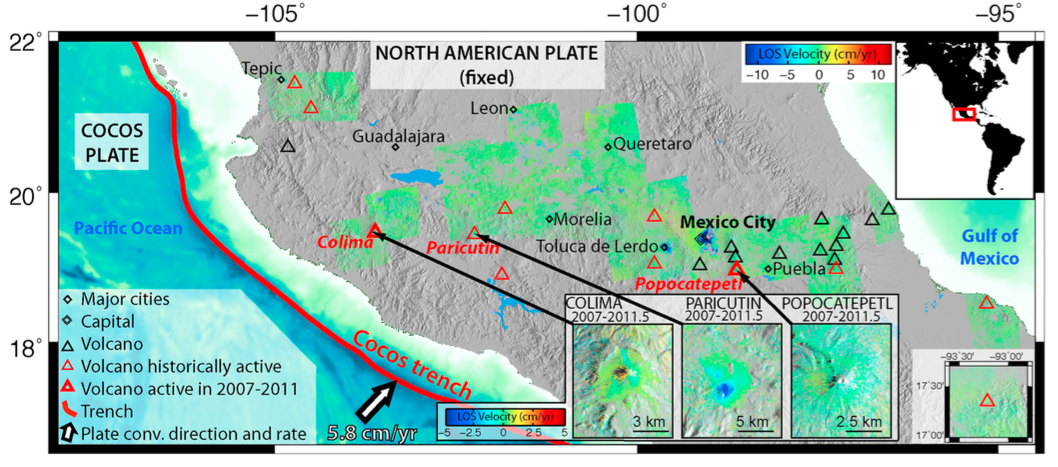 |
Averaged 2007?2011 LOS velocity map of the Trans-Mexican Volcanic Belt, from ALOS InSAR. Only pixels with a temporal coherence larger than 0.7 are shown. Red triangles: historically active volcanoes (bold: those active during the survey period). Black triangles: other volcanoes. Black diamonds: major cities near volcanoes. White arrow: relative plate convergence rate at the Cocos Trench. Positive LOS velocities (uplift) are shown in red and negative LOS velocities (subsidence) in blue. Labeled insets: zoomed in for volcanoes showing deformation (Pari?cutin) or volcanoes active during the time period of the survey (Colima and Popocate?petl). These insets have a smaller color scale. Bottom right inset: LOS velocity map of El Chicho?n, volcano located southeast of the area shown. From: Chaussard et al. 2013. |
||
Reference List: Fournier et al. 2010; Chaussard et al. 2013.
Full References:
Chaussard E, Amelung F, Aoki Y, 2013. Characterization of open and closed volcanic systems in Indonesia and Mexico using InSAR time series. J. Geophys. Res., 118(8), 3957-3969. https://doi.org/10.1002/jgrb.50288
Fournier, T. J., M. E. Pritchard, and S. N. Riddick, 2010. Duration, magnitude, and frequency of subaerial volcano deformation events: New results from Latin America using InSAR and a global synthesis. Geochemistry Geophysics Geosystems, 11: Q01003. https://doi.org/10.1029/2009GC002558
There is no Emissions History data available for Michoacán-Guanajuato.
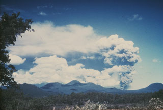 This photo shows an ash plume rising above Parícutin on 9 June 1943, seen here from the Uruapan highway to the east. Prevailing winds distribute the ash plume to the south. Other scoria cones appear on the horizon, some of the 1,000-plus scoria cones within the massive Michoacán-Guanajuato volcanic field.
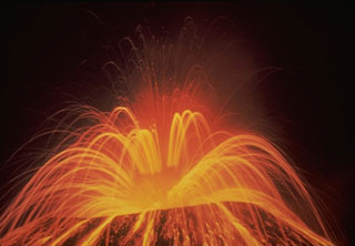 A roughly 15-second time-exposure during the night shows the incandescent trajectories of ejecta from Parícutin on 1 August 1943, near the start of the 1943-52 eruption. Periodic large explosions of bursting lava bubbles in the vent rapidly ejected incandescent lava spatter.
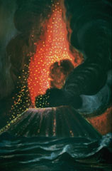 Parícutin ejects a shower of incandescent lava blocks and bombs and an ash plume in this painting by Dr. Atl, the renowned Mexican artist.
 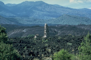 The tower of the unfinished San Juan Parangaricutiro church rises above the lava flows that surrounded it in 1944. The Taquí lava flow began on 8 January 1944 from the SW base of Parícutin. Renewed lava extrusion on 24 April threatened the town of San Juan Parangaricutiro and impacted it 17 June. The church was surrounded by lava in July. By the time the flow ceased in early August it had a length of 10 km.
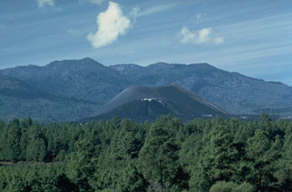 Parícutin, the volcano that erupted in cornfield in 1943, is the best-known feature of the Michoacán-Guanajuato volcanic field. The huge field contains over 1,400 vents covering a wide area of Michoacán and Guanajuato states. Scoria cones are the predominant volcanic form, and lava domes, maars, tuff rings, and lava flows are also present. Parícutin is seen here from the NE with Cerro de Tancítaro in the background.
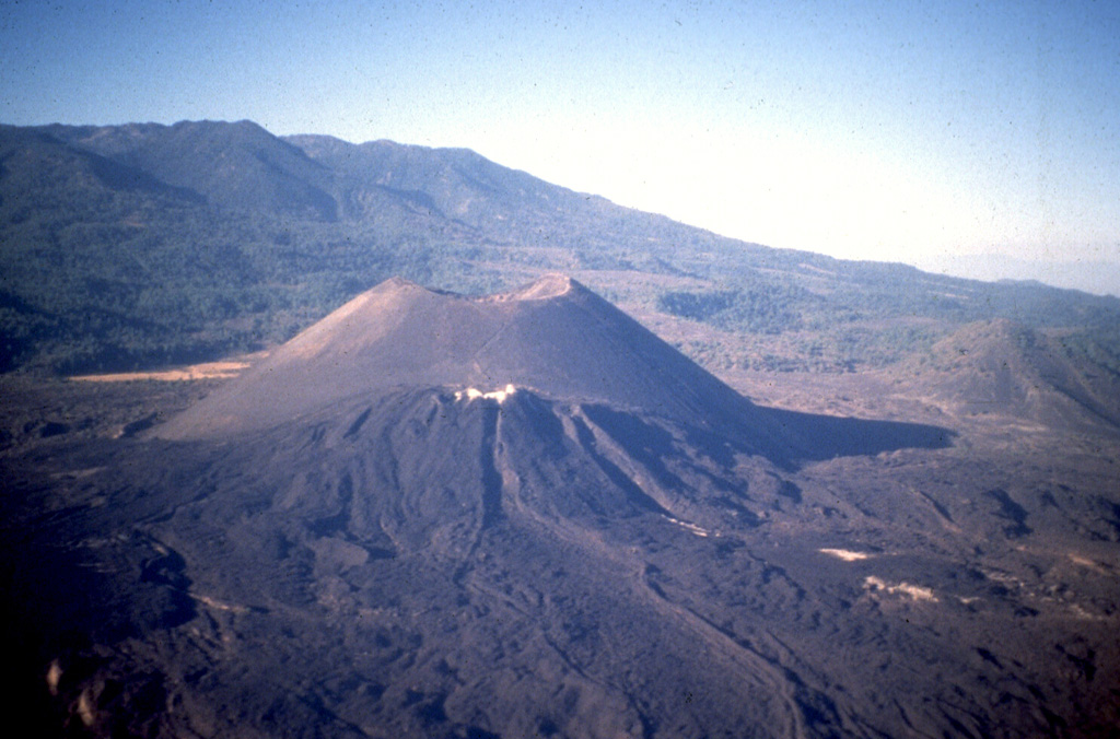
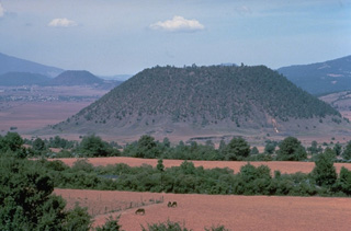 The flat-topped Hoya el Huanillo cinder cone, located about 35 km NE of Parícutin, erupted during the early Holocene about 9300 years ago. It is seen here from the NW with the town of Cherán in the left distance near the Cerro Cucundicata cinder cone. In contrast to many other Michoacán cinder cones, only a small ash-covered lava flow was emitted from Hoya el Huanillo.
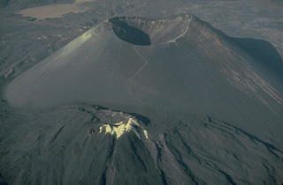 Parícutin cinder cone, born in a Mexican cornfield in 1943, is perhaps the world's best-known example of a pyroclastic cone. Pyroclastic cones (from the Greek words for "fire" and "broken") are created by the accumulation of explosively ejected fragmental material around a volcanic vent. Depending on the dominant type of ejecta, they are called cinder cones, scoria cones, pumice cones, ash cones, or tuff cones. Pyroclastic cones are typically tens of meters to several hundred meters high and often issue lava flows from vents at their base.
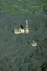 The renowned church of San Juan Parangaricutiro was surrounded by lava flows from Parícutin in July 1944. Only one of the two church steeples had been completed prior to the eruption. The interior of the church was dismantled only days before it was overrun by the lava flow. The west margin of the 1944 lava flow appears at the top, with faintly visible abandoned streets of the town beyond.
 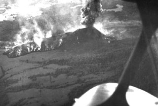 An aerial view from the NNW on 5 March 1943, about two weeks after the start of the Parícutin eruption, shows the Quitzocho lava flow advancing to the NE as an ash plume rises from the scoria cone. The flow was about 6-15 m thick as it advanced.
 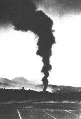 An ash plume rises above the new Parícutin cone on 21 February 1943, the second day of the eruption. The new cone is about 30 m high and is just rising above the treetops in this view from the NE. During this early stage the cone had slope angles of 32 degrees toward the west and lower angles to the east. At this point lava had begun flowing to the east.
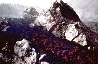 An incandescent lava flow travels down a channel within solidified lava near the SW-flank vents of Parícutin in 1945. Lava flows at this time traveled NW over the site of the village of Parícutin. The Taquí lava flows erupted during 1944-45 and covered about 18 km2. The most striking feature of the Taquí flows was the development of hornitos (rootless vents) when molten lava was ejected through overlying solidified crust.
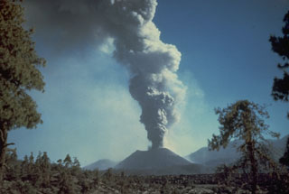 An ash plume rises from Parícutin in October 1944. The photo was taken from the north at the outskirts of the town of San Juan Parangaricutiro. Lava flows in the foreground had already buried the town; the church tower seen in many other photos of the Parícutin eruption is hidden behind the small tree to the right.
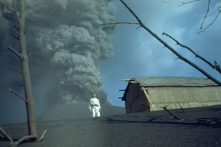 An ash plume at Parícutin in 1944 is photographed from the first observatory cabin 1.5 km north, with local resident Celedonio Gutierrez in the foreground. Gutierrez was born in the nearby town of San Juan Parangaricutiro, which was inundated by lava flows, and became actively involved in collaborations with U.S. scientists throughout the eruption.
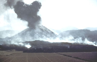 The first lava flow from Parícutin, the Quitzocho flow, moves northward over cornfields prepared for planting. An ash plume rises from the new cone, which by the time of this photo on 25 February, the 5th day of the eruption, was already more than 150 m high. Gas plumes rise from the advancing lava flow.
 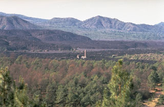 The steeple of the church of San Juan Parangaricutiro rises above surrounding lava fields in the center of the photo, seen here from the NE. The still-unfinished church was inundated by lava in July 1944, a month after flows began advancing into the town. The unvegetated, steeper-sided lava flows in the background were erupted later during 1944-46.
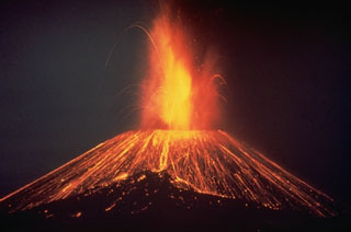 This nighttime time-exposure of México's Parícutin volcano in 1948 shows a Strombolian eruption ejecting incandescent blocks that then rolled down the slopes of the cone. Parícutin is known as the volcano that erupted in a cornfield in 1943. It grew to a height of more than 150 m within the first week of its appearance and remained active until 1952.
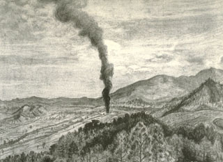 This sketch by Mexican artist Dr. Atl depicts the early moments of the Parícutin eruption in a cornfield near the village from which the volcano was named. A Tarascan farmer, Dionisio Pulido, observed the formation of the eruptive vent in his field about 1630 on 20 February 1943 as he was burning branches.
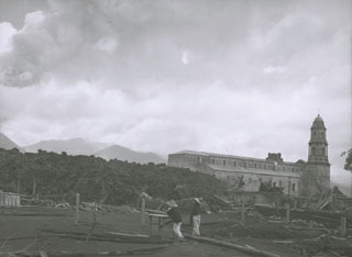 On 7 July 1944 a lava flow (left) approaches the church of San Juan Parangaricutiro. Residents had already evacuated the town when lava first entered the town on 17 June. By the time the flow stopped in early August the church was entirely surrounded by lava.
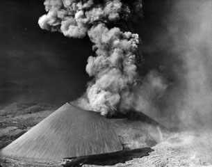 In mid-November 1944 lava broke out of the SSW base of the cone, below the south vent in the crater, seen here from the S. The Ahuán flow advanced over the earlier Taquí flows in the foreground. A small lava intrusion was exposed in the flank of the cone a short distance above the vent. Ahuán flows traveled around the east side of the cone and to the north.
 A villager inspects the roof of a house in the village of Parícutin that was destroyed by heavy ashfall in the first year of the eruption. The village that the volcano was named after was located only 3 km NW of the new cone. Ashfall was particularly intense during the eruption's second to fifth months, and the town's 733 residents were forced to evacuate four months after the eruption began. The Mexican government provided new lands in Caltzontzín, 27 km to the SE.
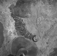 A vertical aerial photo of Parícutin taken on 26 May 1945 shows the cone at the bottom with the partially buried horseshoe-shaped Sapichu vent on its NE flank. Lava flows, forming the lighter-colored areas in the photo, surround the Quitzocho Ridge in the center of the photo and the older Cerro de Jarátiro scoria cone at the top. Ultimately nearly the entire Quitzocho Ridge was buried by lava flows.
 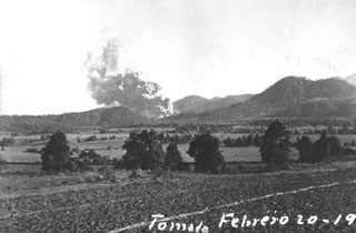 One of the first photographs taken of the Parícutin eruption shows an ash plume rising from the new volcano at 1800 on 20 February 1943, 1.5 hours after the start of the eruption. The photo was taken near Ticuiro, 5 km NNW of the volcano, with the fields of San Juan Parangaricutiro, later overrun by lava flows, in the foreground. Cerro de Canicjuata is the forested older cone to the right.
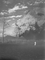 A geologist observes an ash plume rising above the crater of Parícutin on 22 March 1944, as seen from 1 km SW at Mesa de Cocjarao. During March 1944 the eruptive activity ranged from small ash plumes accompanied by deep rumbling to large but almost soundless ash plumes, as was true with the plume shown here.
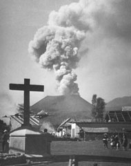 Villagers observe an ash plume rising above Parícutin in 1944 beyond the streets of San Juan Parangaricutiro, soon to be overrun by lava flows. In June and July 1944 lava advanced slowly through the town, which was incrementally evacuated as the flow progressed. Many residents, showing their deep attachment to the land, stayed until the lava overran the last segments of their property.
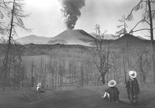 Local Tarascan residents observe Parícutin volcano from Cerro de Equijuata, 2.5 km to the NNE, in March 1944. In this photo taken a little more than a year after the eruption began the Sapichu cone appears at the NE (left-hand) base of Parícutin. The rugged lava flows of June 1943 are visible in the middle of the photo. Heavy ashfall has defoliated trees and a thick ash deposit mantles the landscape.
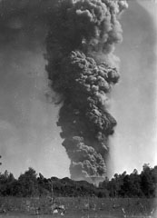 An ash plume towers 6 km above Parícutin on 24 March 1943, a little more than a month after the start of the eruption. The photo was taken from 3 km N in Tititzu and shows the advancing front of the Mesa del Corral lava flow in the middle ground, with the rim of the scoria cone behind it.
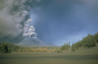 An ash plume rises from the summit crater of Parícutin sometime during 1946-48. A thick ash deposit covers the foreground. An estimated 4,500 cattle and 550 horses died during the heavy ashfall in the early months of the eruption, devastating the local people who depended on the animals for food, plowing, and transportation. Ashfall was deeper than 15 cm over a 300 km2 area around the volcano and continued with varying intensity throughout the 9-year-long eruption.
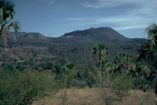 The Jorullo cone eruption began in 1759 in the Michoacán-Guanajuato Volcanic Field. In this view from the NW the unvegetated area visible on the center-horizon is the final lobe that flowed north. Volcán del Norte, one of Jorullo's four flank cones visible on the left horizon, produced a lava flow towards the west during the middle stages of the 1759-74 eruption.
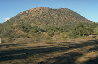 The principal vent of Jorullo formed the scoria cone seen here from the SSE that grew to 250 m in height during the first month and a half of the 1759 eruption. Lava flows were erupted at some unknown later time from four flank vents located along a NE-SW fissure cutting through the main cone.
 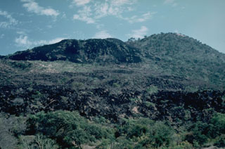 The most recent lava flows of the 1759-74 Jorullo eruption appear in the left and foreground of this view from the north with the sparsely vegetated cone of Jorullo to the upper right. Unlike earlier lava flows that were covered with ashfall from explosive eruptions, this latest does not and remains relatively unvegetated in this 1982 photo. Lava flows were erupted from NE-SW-trending flank vents and covered an area of 9 km2.
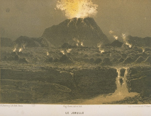 Jorullo, a predecessor to Parícutin, was the first cinder cone of the Michoacán-Guanajuato volcanic field to be formed in historical time. The eruption began on September 29, 1759. Pyroclastic flows and mudflows in the first days caused much damage to neighboring haciendas. The first incandescent bombs were observed on October 8, and after October 14 the eruption was dominantly magmatic. By November 13 the cone had reached 250 m height. Major eruptions continued until 1764, and lesser eruptions were reported until 1774.
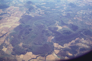 Lava flows in the western part of the Michoacán-Guanajuato volcanic field are seen here from the north. Cerro el Astillero, a scoria cone near the middle right-hand margin of the photo, was the source of the unvegetated lava flow that extends to the east and then south. Cerro el Pedegral, a cone near the lower left, produced lava flows to the west and south toward the upper part of the photo. This lava field is located near the town of Tancítaro and is among the many Holocene flows in the Michoacán-Guanajuato field.
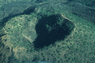 Since the end of the 1759-1774 eruption the Jorullo crater has been collapsing inward along steep, arcuate faults, increasing its dimensions to 400 x 500 m; its depth was 150 m by 1997.
 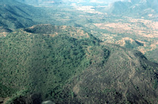 Jorullo scoria cone of the Michoacán-Guanajuato volcanic field is seen here from the ENE. The eruption began with phreatic and phreatomagmatic activity on 29 September 1759 with wet ashfall and lahars that caused damage to neighboring haciendas. By 13 November the cone had reached 250 m in height, and the eruption episode continued until 1774. The sparsely vegetated lava flow to the right was the produced near the end of the eruption.
 Parícutin, the volcano that grew in a cornfield in 1943, is a well-known feature of the Michoacán-Guanajuato volcanic field. The huge field contains over 1,400 vents covering a wide area across the Michoacán and Guanajuato states. Scoria cones are the predominant volcanic landform, and lava domes, maars, tuff rings, and lava flows are also present. Parícutin is seen here from the NE with the Nueva Juatita flank vent in the foreground, the main source of lava during the last five years of the eruption.
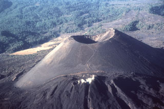 By the end of the 9-year-long eruption of Parícutin, the new scoria cone had risen 424 m above the surface of the original cornfield. The 900-m-wide oval-shaped cone is elongated in a NW-SE direction and is truncated by a circular 280-m-wide crater. The western peak (right) is the highest point on the crater rim. The NE-flank peak of Nuevo Juatita is in the foreground with its top covered by white minerals from fumaroles, and was the main source of lava flows during the last five years of the eruption.
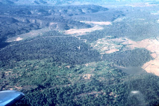 The small light-colored spire in the center of the photo is the renowned steeple of the church of San Juan Parangaricutiro, which was surrounded by lava flows from Parícutin volcano in 1944 in this view from the NE. The steep-sided, viscous lava flows in the background were erupted later, during 1944-46. This is one of numerous lava flows within the Michoacan-Guanajuato volcanic field.
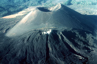 The renowned Parícutin scoria cone, which grew from a Mexican cornfield beginning in 1943, is one of the roughly 1,000 cones that form the massive Michoacán-Guanajuato volcanic field in central Mexico. White mineral deposits formed across the top of Nuevo Juatita in the foreground, a NE-flank vent that was the main source of lava flows during the last five years of the 1943-1952 eruption.
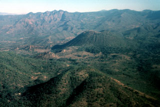 The Jorullo cone (right-center) is seen here from the SSW with Cerro la Pilita cone in the foreground. The small, less-vegetated cones immediately to the left are the SW-flank vents that produced lava flows during the middle part of the 1759-1774 eruption. Cerro la Pilita is an older cone that produced pre-historical lava flows along a narrow channel to the SW.
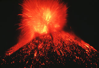 A nighttime Strombolian eruption at Parícutin ejects incandescent blocks and bombs onto the flanks of the scoria cone. Ejecta like this accumulated around the vent to build the cone during February 1943 to February 1952.
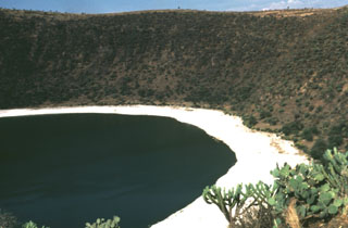 The Valle de Santiago in the NE part of the Michoacán-Guanajuato volcanic field NW of Lake Yuriria contains a group of maars formed by phreatomagmatic eruptions. The maars, four of which are lake-filled, range from 0.8 to 1.8 km in diameter, are 80 to 180 m deep, and are probably Holocene in age. This photo shows the Hoya Rincón de Parangüeo maar at the northern end of the group.
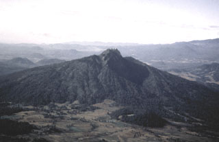 Paracho volcano is one of the many cones of the Michoacán-Guanajuato volcanic field. It is seen here from the west with its summit crater filled by a flat-topped lava dome that is the site of a radio antenna station. The dome fills the upper end of a large erosional valley that extends down the flank from the summit. Edifice collapse has occurred on the eastern side of the volcano, producing a major debris avalanche deposit covering an area of about 175 km2.
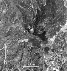 Lava flows from Parícutin (upper center) within the Michoacan-Guanajuato volcanic field cover much of the northern half of this photo. The small white dot immediately NE of the cone is the flank vent of Nuevo Juatita. The latest lava flows that formed during 1952 originated from this vent and form the darker-colored flows that extend to the SE. Cerro Tzirapan is the larger scoria cone near the center, and older cones are to the upper left.
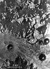 Ashfall from Hoyo el Huanillo scoria cone (lower left) was radiocarbon dated to have formed about 9,300 years ago within the Michoacan-Guanajuato volcanic field. A small ash-covered lava flow extends a short distance to the NW of the cone, which is located 35 km NE of Parícutin. The Cerro Cucundicata scoria cone is to the lower right, and the Cerro Borrego and Cerro Tarucun cones are to the N, NE of the town of Cherán. The eroded Cerro Pacaracua edifice forms much of the upper part of the photo.
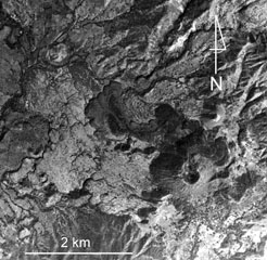 Jorullo volcano and associated lava flows in the Michoacan-Guanajuato volcanic field are visible in the bottom of this photo. Four NE-SW-trending vents flank the main cone, which erupted during 1759-1774. The 1759-74 lava flows appear in varying shades of gray, with the initial (and largest) flows being lighter in color (due to partial ash cover), and the most recent ash-free lava being darker and extending to the NW and NE. Jorullo lies about 80 km SE of Parícutin.
 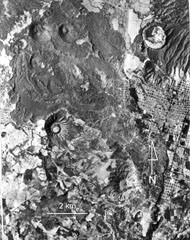 Cerro el Jabalí (upper left) and the adjacent Cerro el Sapien (immediately to the east) of the Michoacan-Guanajuato volcanic field produced the unvegetated lava flow extending across the top of the photo. Ashfall from Cerro el Jabalí scoria cone, located about 15 km SE of Parícutin, erupted about 3,830 years ago. The city of Uruapan is in the right side of the photo, south of the circular Costo (Cerro Cotji) maar.
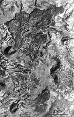 Volcán la Mina is the scoria cone near the center-left margin of the photo with the lava flow emplaced through the collapsed NE crater rim. It formed about 17,170 years ago within the Michoacan-Guanajuato volcanic field, around 90 km ENE of Parícutin. The SW cone containing a crater that also opens to the NE is Volcán el Melón (lower left), which was the source of a lava flow that traveled east to the present-day outskirts of the village of Capula.
 This aerial photo shows part of the Michoacan-Guanajuato volcanic field. Cerro el Pueblito (upper left), radiocarbon dated to about 29,000 years ago, produced the lava flow that extends eastward across the photo that flowed around the older Cerro las Cabras cone to the right. South of this lava flow is the La Vibor lava flow. Cerro Arena is the cone near the center of the photo.
  The large forested (dark) area near the center of the photo is Cerro Tecolote, an eroded stratovolcano located roughly 50 km NE of Parícutin within the Michoacan-Guanajuato volcanic field. Cerro las Cabras (upper left) is a scoria cone that produced the lava flow extending across the upper part of the photo. Mexican Highway 15 travels across the flow, which is of Pleistocene age. Cerro Pajarito is one of the scoria cones south of Cerro Tecolote, and another cone is seen here on the SW flank.
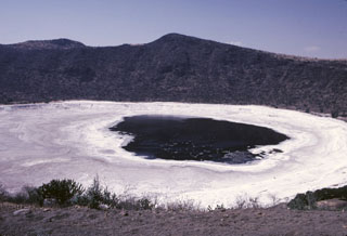 The Hoya Rincón de Parangüeo maar rises directly above the town of the same name located on the lower southern flank. A brackish lake of seasonally variable size partially fills the floor of the 2-km-wide maar, seen here from its southern rim. The high point on the northern rim rises 450 m above the crater floor. Rincón de Parangueo is part of the Valle de Santiago maar field on the NE side of the Michoacán-Guanajuato volcanic field and is about 7 km NW of the town of Valle de Santiago.
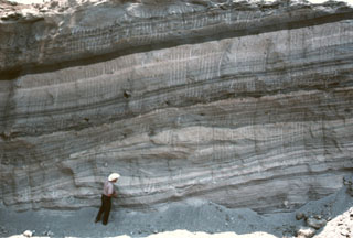 Geologist Todd Housh observes pyroclastic surge deposits in the wall of an abandoned quarry on the north flank of Hoya Estrada maar, directly west of the town of Valle de Santiago. The exposure shows laminar and dune form-bedded surge deposits at the bottom with laminar ashfall layers at the top. The direction that the pyroclastic surges traveled was from right to left.
 The walls of a quarry on the SW flank of Hoya Estrada maar close to the city of Valle de Santiago show a spectacular sequence of deposits from the maar-forming eruptions. Most of the outcrop consists of gray-colored dominantly planar pyroclastic surge beds. The three prominent light-colored layers are ashfall deposits. The largest ash layer is about 2 m thick just above the middle of the outcrop in this view looking towards the vent.
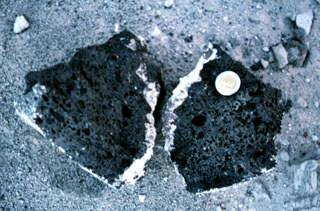 A basaltic clast with a light-colored silicic rim from the Hoya Estrada maar. The coin provides scale.
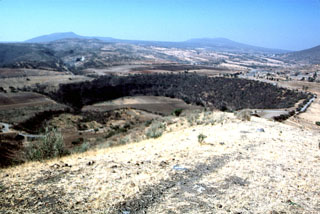 Several maars of the Michoacan-Guanajuato volcanic field are visible in this photo. The 600-m-wide Hoya Solis maar is seen from the SW rim of Hoya Blanca maar, immediately SW of the city of Valle de Santiago. The rim of Hoya de Cintora maar lies beyond Hoya Solis below the far-left horizon.
The maps shown below have been scanned from the GVP map archives and include the volcano on this page. Clicking on the small images will load the full 300 dpi map. Very small-scale maps (such as world maps) are not included. The maps database originated over 30 years ago, but was only recently updated and connected to our main database. We welcome users to tell us if they see incorrect information or other problems with the maps; please use the Contact GVP link at the bottom of the page to send us email.
The following 623 samples associated with this volcano can be found in the Smithsonian's NMNH Department of Mineral Sciences collections, and may be availble for research (contact the Rock and Ore Collections Manager). Catalog number links will open a window with more information.
| Catalog Number | Sample Description | Lava Source | Collection Date |
|---|---|---|---|
| NMNH 104717 | Sal Ammoniac | PARICUTIN | -- |
| NMNH 104717-00 | Sal Ammoniac | -- | -- |
| NMNH 104718-00 | Sal Ammoniac | -- | -- |
| NMNH 104718-01 | Sal Ammoniac | -- | -- |
| NMNH 105184-00 | Sal Ammoniac | -- | -- |
| NMNH 105184-01 | Sal Ammoniac | -- | -- |
| NMNH 105184-02 | Sal Ammoniac | -- | -- |
| NMNH 105184-03 | Sal Ammoniac | -- | -- |
| NMNH 105184-04 | Sal Ammoniac | -- | -- |
| NMNH 105184-05 | Sal Ammoniac | -- | -- |
| NMNH 105184-06 | Sal Ammoniac | -- | -- |
| NMNH 105184-07 | Sal Ammoniac | -- | -- |
| NMNH 105184-08 | Sal Ammoniac | -- | -- |
| NMNH 105184-09 | Sal Ammoniac | -- | -- |
| NMNH 105184-10 | Sal Ammoniac | -- | -- |
| NMNH 105184-11 | Sal Ammoniac | -- | -- |
| NMNH 105184-12 | Sal Ammoniac | -- | -- |
| NMNH 106882-00 | Sal Ammoniac | -- | -- |
| NMNH 106882-01 | Sal Ammoniac | -- | -- |
| NMNH 106923 | Volcanic Sublimate | PARICUTIN | -- |
| NMNH 107427 | Volcanic Sublimate | PARICUTIN | -- |
| NMNH 108058 | Basalt | PARICUTIN, QUITZOCHO FLOW | -- |
| NMNH 108059 | Basalt | PARICUTIN | -- |
| NMNH 108060 | Basalt | PARICUTIN, QUITZOCHO RIDGE, SMALL FLOW | -- |
| NMNH 108061 | Basalt | PARICUTIN | -- |
| NMNH 108062 | Basalt | PARICUTIN | -- |
| NMNH 108063 | Basalt | PARICUTIN | -- |
| NMNH 108064 | Basalt | PARICUTIN | -- |
| NMNH 108065 | Basalt | PARICUTIN | -- |
| NMNH 108066 | Basalt | PARICUTIN, SAPICHU VENT | -- |
| NMNH 108067 | Basalt | PARICUTIN, SAPICHU VENT | -- |
| NMNH 108068 | Basalt | PARICUTIN, SAPICHU VENT | -- |
| NMNH 108069 | Basalt | PARICUTIN, SAPICHU VENT | -- |
| NMNH 108070 | Basalt | PARICUTIN, SAPICHU VENT | -- |
| NMNH 108071 | Basalt | PARICUTIN, SAPICHU VENT | -- |
| NMNH 108072 | Basalt | PARICUTIN, SAPICHU VENT | -- |
| NMNH 108072 | Basalt | PARICUTIN | -- |
| NMNH 108073 | Basalt | PARICUTIN | -- |
| NMNH 108074 | Basalt | PARICUTIN, SAPICHU VENT | -- |
| NMNH 108075 | Basalt | PARICUTIN, SAPICHU VENT | -- |
| NMNH 108076 | Basalt | PARICUTIN, SAPICHU VENT | -- |
| NMNH 108077 | Basalt | PARICUTIN, SAPICHU VENT | -- |
| NMNH 108078 | Basalt | PARICUTIN, SAPICHU VENT | -- |
| NMNH 108080 | Basalt | PARICUTIN, PARANGARICUTIRO TONGUE | -- |
| NMNH 108081 | Basalt | PARICUTIN, PARANGARICUTIRO TONGUE | -- |
| NMNH 108082 | Basalt | PARICUTIN, PARANGARICUTIRO TONGUE | -- |
| NMNH 108083 | Basalt | PARICUTIN | -- |
| NMNH 108084-1 | Basalt | PARICUTIN | -- |
| NMNH 108084-2 | Basalt | PARICUTIN | -- |
| NMNH 108085 | Basalt | PARICUTIN | -- |
| NMNH 108086 | Basalt | PARICUTIN | -- |
| NMNH 108087 | Basalt | PARICUTIN | -- |
| NMNH 108088 | Basalt | PARICUTIN | -- |
| NMNH 108089 | Basalt | PARICUTIN | -- |
| NMNH 108090 | Basalt | PARICUTIN | -- |
| NMNH 108091 | Basalt | PARICUTIN | -- |
| NMNH 108092 | Basalt | PARICUTIN | -- |
| NMNH 108093 | Basalt | PARICUTIN | -- |
| NMNH 108094 | Basalt | PARICUTIN | -- |
| NMNH 108095 | Basalt | PARICUTIN | -- |
| NMNH 108096 | Basalt | PARICUTIN | -- |
| NMNH 108097 | Basalt | PARICUTIN | -- |
| NMNH 108098 | Basalt | PARICUTIN | -- |
| NMNH 108098 | Basalt | PARICUTIN | -- |
| NMNH 108099 | Basalt | PARICUTIN | -- |
| NMNH 108100 | Basalt | PARICUTIN | -- |
| NMNH 108100 | Basalt | PARICUTIN | -- |
| NMNH 108101 | Basalt | PARICUTIN | -- |
| NMNH 108102 | Basalt | PARICUTIN | -- |
| NMNH 108103 | Basalt | PARICUTIN | -- |
| NMNH 108104 | Basalt | PARICUTIN | -- |
| NMNH 108105 | Basalt | PARICUTIN | -- |
| NMNH 108106 | Basalt | PARICUTIN | -- |
| NMNH 108108 | Basalt | PARICUTIN | -- |
| NMNH 108109 | Basalt | PARICUTIN | -- |
| NMNH 108110 | Basalt | PARICUTIN | -- |
| NMNH 108112-1 | Basalt | PARICUTIN | -- |
| NMNH 108112-2 | Basalt | PARICUTIN | -- |
| NMNH 108113 | Basalt | PARICUTIN | -- |
| NMNH 108114-1 | Basalt | PARICUTIN | -- |
| NMNH 108114-2 | Basalt | PARICUTIN | -- |
| NMNH 108115 | Basalt | PARICUTIN | -- |
| NMNH 108115 | Basalt | PARICUTIN | -- |
| NMNH 108116 | Basalt | PARICUTIN | -- |
| NMNH 108117 | Basalt | PARICUTIN | -- |
| NMNH 108118 | Basalt | PARICUTIN | -- |
| NMNH 108119 | Basalt | PARICUTIN | -- |
| NMNH 108119 | Basalt | PARICUTIN | -- |
| NMNH 108120 | Basalt | PARICUTIN | -- |
| NMNH 108120-1 | Basalt | PARICUTIN | -- |
| NMNH 108120-2 | Basalt | PARICUTIN | -- |
| NMNH 108121-1 | Basalt | PARICUTIN | -- |
| NMNH 108121-2 | Basalt | PARICUTIN | -- |
| NMNH 108121-3 | Basalt | PARICUTIN | -- |
| NMNH 108122 | Basalt | PARICUTIN | -- |
| NMNH 108122 | Basalt | PARICUTIN | -- |
| NMNH 108123 | Basalt | PARICUTIN | -- |
| NMNH 108124 | Basalt | PARICUTIN | -- |
| NMNH 108125 | Basalt | PARICUTIN | -- |
| NMNH 108126-1 | Basalt | PARICUTIN | -- |
| NMNH 108126-2 | Basalt | PARICUTIN | -- |
| NMNH 108126-3 | Basalt | PARICUTIN | -- |
| NMNH 108127-1 | Basalt | PARICUTIN | -- |
| NMNH 108127-2 | Basalt | PARICUTIN | -- |
| NMNH 108128 | Basalt | PARICUTIN | -- |
| NMNH 108128 | Basalt | PARICUTIN | -- |
| NMNH 108129 | Basalt | PARICUTIN | -- |
| NMNH 108130 | Basalt | PARICUTIN | -- |
| NMNH 108131 | Basalt | PARICUTIN | -- |
| NMNH 108132-1 | Basalt | PARICUTIN | -- |
| NMNH 108132-2 | Basalt | PARICUTIN | -- |
| NMNH 108133-1 | Basalt | PARICUTIN | -- |
| NMNH 108133-2 | Basalt | PARICUTIN | -- |
| NMNH 108134 | Volcanic Ash | PARICUTIN | -- |
| NMNH 108135 | Unidentified | PARICUTIN | -- |
| NMNH 108136 | Unidentified | PARICUTIN | -- |
| NMNH 108137 | Unidentified | PARICUTIN | -- |
| NMNH 108138 | Unidentified | PARICUTIN | -- |
| NMNH 108139 | Unidentified | PARICUTIN | -- |
| NMNH 108140 | Volcanic Ash | PARICUTIN | -- |
| NMNH 108141 | Volcanic Ash | PARICUTIN | -- |
| NMNH 108142 | Volcanic Ash | PARICUTIN | -- |
| NMNH 108143 | Volcanic Ash | PARICUTIN | -- |
| NMNH 108144 | Volcanic Ash | PARICUTIN | -- |
| NMNH 108145 | Volcanic Ash | PARICUTIN | -- |
| NMNH 108146 | Volcanic Ash | PARICUTIN | -- |
| NMNH 108147 | Volcanic Ash | PARICUTIN | -- |
| NMNH 108148 | Volcanic Ash | PARICUTIN | -- |
| NMNH 108149 | Volcanic Ash | PARICUTIN | -- |
| NMNH 108150 | Volcanic Ash | PARICUTIN | -- |
| NMNH 108151 | Unidentified | PARICUTIN | -- |
| NMNH 108152 | Volcanic Ash | PARICUTIN | -- |
| NMNH 108153 | Unidentified | PARICUTIN | -- |
| NMNH 108154 | Volcanic Ash | PARICUTIN | -- |
| NMNH 108155 | Unidentified | PARICUTIN, SAPICHU VENT | -- |
| NMNH 108156 | Unidentified | PARICUTIN | -- |
| NMNH 108157 | Volcanic Ash | PARICUTIN | -- |
| NMNH 108158 | Unidentified | PARICUTIN | -- |
| NMNH 108160-00 | Aphthitalite | -- | -- |
| NMNH 108162-00 | Chloraluminite | -- | -- |
| NMNH 108163 | Basalt | PARICUTIN | -- |
| NMNH 108166-1 | Basalt | PARICUTIN | -- |
| NMNH 108166-2 | Basalt | PARICUTIN | -- |
| NMNH 108166-3 | Basalt | PARICUTIN | -- |
| NMNH 108166-4 | Basalt | PARICUTIN | -- |
| NMNH 108166-5 | Basalt | PARICUTIN | -- |
| NMNH 108166-6 | Basalt | PARICUTIN | -- |
| NMNH 108167 | Basalt | PARICUTIN | -- |
| NMNH 108170-1 | Basalt | PARICUTIN | -- |
| NMNH 108170-2 | Basalt | PARICUTIN | -- |
| NMNH 108171 | Basalt | PARICUTIN | -- |
| NMNH 108172 | Basalt | PARICUTIN | -- |
| NMNH 108173 | Volcanic Ash | PARICUTIN | -- |
| NMNH 108174 | Volcanic Ash | PARICUTIN | -- |
| NMNH 108175 | Volcanic Sublimate | PARICUTIN | -- |
| NMNH 108176 | Basalt | PARICUTIN | -- |
| NMNH 108176 | Basalt | PARICUTIN | -- |
| NMNH 108184 | Basalt | PARICUTIN | -- |
| NMNH 108293 | Volcanic Bomb | PARICUTIN | -- |
| NMNH 108293 | Volcanic Bomb | PARICUTIN | -- |
| NMNH 108294 | Volcanic Bomb | PARICUTIN | -- |
| NMNH 108295 | Basalt | PARICUTIN | -- |
| NMNH 108304 | Basalt | PARICUTIN | -- |
| NMNH 108305 | Basalt | PARICUTIN | -- |
| NMNH 108607 | Lava | PARICUTIN | -- |
| NMNH 108608 | Lava | PARICUTIN | -- |
| NMNH 108609 | Basalt | PARICUTIN | -- |
| NMNH 108795-1 | Basalt | PARICUTIN | -- |
| NMNH 108795-2 | Basalt | PARICUTIN | -- |
| NMNH 108795-3 | Basalt | PARICUTIN | -- |
| NMNH 108795-4 | Basalt | PARICUTIN | -- |
| NMNH 108796 | Painting | PARICUTIN | -- |
| NMNH 108862 | Basalt | PARICUTIN | -- |
| NMNH 108863 | Basalt | PARICUTIN | -- |
| NMNH 108984-1 | Lava | -- | -- |
| NMNH 108986 | Basalt | PARICUTIN | -- |
| NMNH 108987 | Basalt | PARICUTIN | -- |
| NMNH 109064 | Basalt | PARICUTIN | -- |
| NMNH 109089 | Basalt | PARICUTIN | -- |
| NMNH 109353 | Basalt | PARICUTIN | -- |
| NMNH 109354 | Basalt | PARICUTIN, ZAPICHO CINDER CONE | -- |
| NMNH 114709 | Volcanic Ash | PARICUTIN | -- |
| NMNH 114711 | Volcanic Rock | PARICUTIN | -- |
| NMNH 114712 | Volcanic Rock | PARICUTIN | -- |
| NMNH 114713 | Volcanic Rock | PARICUTIN | -- |
| NMNH 114714 | Volcanic Rock | PARICUTIN | -- |
| NMNH 114715 | Basalt | PARICUTIN | -- |
| NMNH 114716 | Unidentified | PARICUTIN | -- |
| NMNH 114717 | Volcanic Ash | PARICUTIN | -- |
| NMNH 114718 | Opal | PARICUTIN | -- |
| NMNH 114719 | Opal | PARICUTIN | -- |
| NMNH 114720 | Basalt | PARICUTIN | -- |
| NMNH 114721 | Opal | PARICUTIN | -- |
| NMNH 114722 | Unidentified | PARICUTIN | -- |
| NMNH 114723 | Ammonium Chloride | PARICUTIN | -- |
| NMNH 114724 | Volcanic Sublimate | PARICUTIN | -- |
| NMNH 114725 | Sal Ammoniac | PARICUTIN | -- |
| NMNH 114726 | Unidentified | PARICUTIN | -- |
| NMNH 114727 | Volcanic Ash (?) | PARICUTIN | -- |
| NMNH 114728 | Volcanic Sublimate | PARICUTIN | -- |
| NMNH 116284-1 | Basalt | JORULLO | 10 Dec 1946 |
| NMNH 116284-10A | Andesitic Rock | JORULLO | 12 Dec 1946 |
| NMNH 116284-10B | Andesitic Rock | JORULLO | 12 Dec 1946 |
| NMNH 116284-11A | Andesitic Rock | JORULLO | 12 Dec 1946 |
| NMNH 116284-11B | Andesitic Rock | JORULLO | 12 Dec 1946 |
| NMNH 116284-11C | Andesitic Rock | JORULLO | 12 Dec 1946 |
| NMNH 116284-12 | Andesitic Rock | JORULLO | 12 Dec 1946 |
| NMNH 116284-13A | Andesitic Rock | JORULLO | 12 Dec 1946 |
| NMNH 116284-13B | Andesitic Rock | JORULLO | 12 Dec 1946 |
| NMNH 116284-14 | Andesitic Rock | JORULLO | 12 Dec 1946 |
| NMNH 116284-15 | Andesitic Rock | JORULLO | 12 Dec 1946 |
| NMNH 116284-16 | Andesitic Rock | JORULLO | 12 Dec 1946 |
| NMNH 116284-17 | Andesitic Rock | JORULLO | 12 Dec 1946 |
| NMNH 116284-18 | Andesitic Rock | JORULLO | 12 Dec 1946 |
| NMNH 116284-19 | Andesitic Rock | JORULLO | 12 Dec 1946 |
| NMNH 116284-1A | Basalt | JORULLO | 10 Dec 1946 |
| NMNH 116284-1B | Basalt | JORULLO | 10 Dec 1946 |
| NMNH 116284-2 | Volcanic Ash | JORULLO | 11 Dec 1946 |
| NMNH 116284-20A | Basalt | JORULLO | 12 Dec 1946 |
| NMNH 116284-20B | Basalt | JORULLO | 12 Dec 1946 |
| NMNH 116284-20C | Basalt | JORULLO | 12 Dec 1946 |
| NMNH 116284-21B | Basalt | JORULLO | 12 Dec 1946 |
| NMNH 116284-21C | Basalt | JORULLO | 12 Dec 1946 |
| NMNH 116284-22 | Volcanic Ash | JORULLO | 12 Dec 1946 |
| NMNH 116284-23 | Volcanic Ash | JORULLO | 12 Dec 1946 |
| NMNH 116284-24 | Basalt | JORULLO | 12 Dec 1946 |
| NMNH 116284-3 | Volcanic Ash | JORULLO | 11 Dec 1946 |
| NMNH 116284-4 | Basalt | JORULLO | 11 Dec 1946 |
| NMNH 116284-5 | Volcanic Ash | JORULLO | 11 Dec 1946 |
| NMNH 116284-6 | Volcanic Bomb | JORULLO | 12 Dec 1946 |
| NMNH 116284-7 | Volcanic Bomb | JORULLO | 12 Dec 1946 |
| NMNH 116284-8 | Andesitic Rock | JORULLO | 12 Dec 1946 |
| NMNH 116284-9 | Andesitic Rock | JORULLO | 12 Dec 1946 |
| NMNH 116289-1 | Lava | PARICUTIN | -- |
| NMNH 116289-10 | Lava | PARICUTIN, ZAPICHU | 10 Jun 1947 |
| NMNH 116289-11 | Lava | PARICUTIN | 5 Sep 1947 |
| NMNH 116289-12 | Lava | PARICUTIN | 30 Nov 1947 |
| NMNH 116289-13 | Lava | PARICUTIN | 2 Sep 1948 |
| NMNH 116289-14 | Basaltic Andesite | PARICUTIN | 19 May 1949 |
| NMNH 116289-15 | Basaltic Andesite | PARICUTIN | 13 Dec 1949 |
| NMNH 116289-16 | Basaltic Andesite | PARICUTIN | 1 Sep 1950 |
| NMNH 116289-17 | Basaltic Andesite | PARICUTIN | 25 May 1951 |
| NMNH 116289-18 | Basaltic Andesite | PARICUTIN | 28 Nov 1951 |
| NMNH 116289-19 | Basaltic Andesite | PARICUTIN, NUEVO JUATITA | 8 Mar 1952 |
| NMNH 116289-2 | Lava | PARICUTIN | -- |
| NMNH 116289-20 | Xenolithic Volcanic Bomb | PARICUTIN | 1 May 1943 |
| NMNH 116289-21 | Dacitic Xenolith | PARICUTIN | 1 Jan 1943 |
| NMNH 116289-22 | Xenolith | PARICUTIN | -- |
| NMNH 116289-23 | Granitic Xenolith | PARICUTIN | -- |
| NMNH 116289-3 | Lava | PARICUTIN | -- |
| NMNH 116289-4 | Lava | PARICUTIN | -- |
| NMNH 116289-5 | Lava | PARICUTIN | -- |
| NMNH 116289-6 | Lava | PARICUTIN | -- |
| NMNH 116289-7 | Lava | PARICUTIN | -- |
| NMNH 116289-8 | Lava | PARICUTIN, AHUAN VENT | -- |
| NMNH 116289-9 | Lava | PARICUTIN, ZAPICHU | 9 Apr 1947 |
| NMNH 116290 | Aluminous Basalt | PARICUTIN | -- |
| NMNH 116291-1 | Lava | PARICUTIN | -- |
| NMNH 116291-2 | Lava | PARICUTIN | -- |
| NMNH 116291-3 | Lava | PARICUTIN | -- |
| NMNH 116291-4 | Basaltic Volcanic Bomb | PARICUTIN | 21 Jun 1943 |
| NMNH 116291-5 | Lava | PARICUTIN | -- |
| NMNH 116292-1 | Volcanic Ash | PARICUTIN | 25 Mar 1943 |
| NMNH 116292-2 | Volcanic Ash | PARICUTIN | 27 Mar 1943 |
| NMNH 116292-3 | Lapilli | PARICUTIN | 18 Jul 1943 |
| NMNH 116292-4 | Lava | PARICUTIN | 16 Jul 1943 |
| NMNH 116292-5 | Basaltic Volcanic Bomb | PARICUTIN | -- |
| NMNH 116292-6 | Basaltic Volcanic Bomb | PARICUTIN | -- |
| NMNH 116292-7 | Xenolithic Volcanic Bomb | PARICUTIN | 4 Feb 1944 |
| NMNH 116292-8 | Xenolithic Volcanic Bomb | PARICUTIN | 4 Feb 1944 |
| NMNH 116292-9 | Xenolithic Volcanic Bomb | PARICUTIN | 4 Feb 1944 |
| NMNH 116293-1 | Obsidian Xenolith | PARICUTIN | 1 Jul 1945 |
| NMNH 116293-1 | Pumice | PARICUTIN | -- |
| NMNH 116293-10 | Lava | PARICUTIN | -- |
| NMNH 116293-11 | Volcanic Bomb | PARICUTIN | -- |
| NMNH 116293-12 | Volcanic Bomb | PARICUTIN | -- |
| NMNH 116293-2 | White Xenolith | PARICUTIN | 1 Mar 1944 |
| NMNH 116293-3 | Xenolith | PARICUTIN | 1 Jan 1943 |
| NMNH 116293-4 | Dacitic Xenolith | PARICUTIN | 1 Jan 1943 |
| NMNH 116293-5 | Dacitic Xenolith | PARICUTIN | -- |
| NMNH 116293-6 | Xenolith | PARICUTIN | -- |
| NMNH 116293-7 | Lava | PARICUTIN | -- |
| NMNH 116293-8 | Lava | PARICUTIN | -- |
| NMNH 116293-9 | Lava | PARICUTIN | -- |
| NMNH 116294-1 | Lava | PARICUTIN | 1 Jan 1945 |
| NMNH 116294-10 | Volcanic Bomb | PARICUTIN | 1 Jan 1945 |
| NMNH 116294-11 | Lava | PARICUTIN | 1 Jan 1945 |
| NMNH 116294-12 | Lava | PARICUTIN | 1 Jan 1945 |
| NMNH 116294-13 | Lava | PARICUTIN | 1 Jan 1945 |
| NMNH 116294-14 | Lava | PARICUTIN | 1 Jan 1945 |
| NMNH 116294-15 | Lava | PARICUTIN | 1 Jan 1945 |
| NMNH 116294-16 | Lava | PARICUTIN | 1 Jan 1945 |
| NMNH 116294-17 | Lava | PARICUTIN | 1 Jan 1945 |
| NMNH 116294-18 | Lava | PARICUTIN | 1 Jan 1945 |
| NMNH 116294-19 | Lava | PARICUTIN | 1 Jan 1945 |
| NMNH 116294-2 | Basaltic Volcanic Bomb | PARICUTIN | 1 Jan 1945 |
| NMNH 116294-20 | Lava | PARICUTIN | 1 Jan 1945 |
| NMNH 116294-21 | Lava | PARICUTIN | 1 Jan 1946 |
| NMNH 116294-22 | Xenolith | PARICUTIN | 1 Jan 1946 |
| NMNH 116294-23 | Volcanic Bomb | PARICUTIN | 1 Jan 1946 |
| NMNH 116294-24 | Lava | PARICUTIN | 7 Feb 1946 |
| NMNH 116294-25 | Lava | PARICUTIN | 1 Jan 1946 |
| NMNH 116294-26 | Lava | PARICUTIN | 1 Jan 1946 |
| NMNH 116294-27 | Lava | PARICUTIN | 1 Jan 1946 |
| NMNH 116294-28 | Lava | PARICUTIN | 1 Jan 1946 |
| NMNH 116294-29 | Xenolithic Volcanic Bomb | PARICUTIN | 31 Jan 1946 |
| NMNH 116294-3 | Lava | PARICUTIN | 1 Jan 1945 |
| NMNH 116294-4 | Lava | PARICUTIN | 1 Jan 1945 |
| NMNH 116294-5 | Volcanic Bomb | PARICUTIN | 1 Jan 1945 |
| NMNH 116294-6 | Lava | PARICUTIN | 1 Jan 1945 |
| NMNH 116294-7 | Lava | PARICUTIN | 1 Jan 1945 |
| NMNH 116294-8 | Lava | PARICUTIN | 1 Jan 1945 |
| NMNH 116294-9 | Lava | PARICUTIN | 1 Jan 1945 |
| NMNH 116295-1 | Basalt | PARICUTIN | 23 Dec 1946 |
| NMNH 116295-10 | Lava | PARICUTIN, PUERTECITO | 25 Feb 1947 |
| NMNH 116295-11 | Lava | PARICUTIN | 30 May 1947 |
| NMNH 116295-12 | Xenolith | PARICUTIN | -- |
| NMNH 116295-13 | Volcanic Bomb | PARICUTIN | 10 Jun 1947 |
| NMNH 116295-14 | Volcanic Bomb | PARICUTIN | 10 Jun 1947 |
| NMNH 116295-16 | Volcanic Bomb | PARICUTIN | 15 Jun 1947 |
| NMNH 116295-17 | Lava | PARICUTIN, JUATITO | 21 Aug 1947 |
| NMNH 116295-18 | Lava | PARICUTIN, PUERTECITO | 28 Aug 1947 |
| NMNH 116295-19 | Lava | PARICUTIN | 28 Aug 1947 |
| NMNH 116295-2 | Basalt | PARICUTIN | 26 Dec 1946 |
| NMNH 116295-20 | Lava | PARICUTIN | 20 Sep 1947 |
| NMNH 116295-21 | Lava | PARICUTIN | 29 Sep 1947 |
| NMNH 116295-22 | Lava | PARICUTIN | 24 Sep 1947 |
| NMNH 116295-23 | Lava | PARICUTIN | 24 Sep 1947 |
| NMNH 116295-24 | Lava | PARICUTIN | 29 Sep 1947 |
| NMNH 116295-25 | Lava | PARICUTIN | 29 Sep 1947 |
| NMNH 116295-26 | Lava | PARICUTIN | 1 Oct 1947 |
| NMNH 116295-27 | Lava | PARICUTIN | 1 Oct 1947 |
| NMNH 116295-28 | Volcanic Bomb | PARICUTIN | 30 Nov 1947 |
| NMNH 116295-29 | Basaltic Andesite | PARICUTIN | 30 Nov 1947 |
| NMNH 116295-3 | Lava | PARICUTIN | 9 Jan 1947 |
| NMNH 116295-30 | Lava | PARICUTIN | 30 Dec 1947 |
| NMNH 116295-31 | Volcanic Bomb (?) | PARICUTIN | -- |
| NMNH 116295-32 | Lava | PARICUTIN | 12 Jan 1948 |
| NMNH 116295-33 | Salic Xenolith | PARICUTIN, TZINTZUNGO, CERRO DE | 22 Jan 1948 |
| NMNH 116295-34 | Basaltic Lava | PARICUTIN | 2 Sep 1948 |
| NMNH 116295-35 | Xenolith | PARICUTIN, TZINTZUNGO, CERRO DE | 1 Apr 1948 |
| NMNH 116295-36 | Lava | PARICUTIN, PARACHO, CERROS DE | 2 Aug 1948 |
| NMNH 116295-37 | Lava | PARICUTIN | 18 Nov 1948 |
| NMNH 116295-4 | Lava | PARICUTIN | 9 Jan 1947 |
| NMNH 116295-5 | Lava | PARICUTIN | 18 Jan 1947 |
| NMNH 116295-6 | Lava | PARICUTIN | 18 Jan 1947 |
| NMNH 116295-7 | Lava | PARICUTIN, CAPATZIN | 18 Jan 1947 |
| NMNH 116295-8 | Lava | PARICUTIN, AHUAN | 20 Feb 1947 |
| NMNH 116295-9 | Lava | PARICUTIN, PUERTECITO | 20 Feb 1947 |
| NMNH 116296-1 | Basaltic Andesite | PARICUTIN | 1 Jan 1949 |
| NMNH 116296-10 | Basaltic Andesite | PARICUTIN | 8 Jul 1950 |
| NMNH 116296-11 | Basaltic Andesite | PARICUTIN | 1 Jan 1950 |
| NMNH 116296-12 | Basaltic Andesite | PARICUTIN | 1 Jan 1950 |
| NMNH 116296-13 | Basaltic Andesite | PARICUTIN | 1 Jan 1947 |
| NMNH 116296-14 | Basaltic Andesite | PARICUTIN | 1 Jan 1950 |
| NMNH 116296-15 | Basaltic Andesite | PARICUTIN | 1 Jan 1950 |
| NMNH 116296-16 | Basaltic Andesite | PARICUTIN | 1 Jan 1950 |
| NMNH 116296-17 | Basaltic Andesite | PARICUTIN | 29 Dec 1950 |
| NMNH 116296-18 | Basaltic Andesite | PARICUTIN | 11 Mar 1951 |
| NMNH 116296-19 | Basaltic Andesite | PARICUTIN | 11 Mar 1951 |
| NMNH 116296-2 | Basaltic Andesite | PARICUTIN | 1 Jan 1949 |
| NMNH 116296-20 | Basaltic Andesite | PARICUTIN | 11 Mar 1951 |
| NMNH 116296-21 | Basaltic Andesite | PARICUTIN | 25 May 1951 |
| NMNH 116296-22 | Basaltic Andesite | PARICUTIN | 11 Jul 1951 |
| NMNH 116296-23 | Basaltic Andesite | PARICUTIN | 11 Jul 1951 |
| NMNH 116296-24 | Basaltic Andesite | PARICUTIN | 11 Jul 1951 |
| NMNH 116296-25 | Basaltic Andesite | PARICUTIN | 12 Jul 1951 |
| NMNH 116296-26 | Basaltic Andesite | PARICUTIN | 11 Jul 1951 |
| NMNH 116296-27 | Basaltic Andesite | PARICUTIN | 15 Oct 1951 |
| NMNH 116296-28 | Basaltic Andesite | PARICUTIN | -- |
| NMNH 116296-29 | Volcanic Ash | PARICUTIN | 29 Jan 1952 |
| NMNH 116296-3 | Basaltic Andesite | PARICUTIN | 17 Oct 1949 |
| NMNH 116296-30 | Basaltic (?) Andesite | PARICUTIN | 1 Jan 1952 |
| NMNH 116296-31 | Basaltic (?) Andesite | PARICUTIN | 30 Apr 1952 |
| NMNH 116296-32 | Basaltic Andesite | PARICUTIN | 30 Apr 1952 |
| NMNH 116296-33 | Basaltic Andesite | PARICUTIN | 31 Jan 1952 |
| NMNH 116296-34 | Basaltic Andesite | PARICUTIN | 30 Apr 1952 |
| NMNH 116296-35 | Monzonite (?) | PARICUTIN | -- |
| NMNH 116296-36 | Basaltic Andesite | PARICUTIN, NUEVO JUATITA | 27 Oct 1952 |
| NMNH 116296-37 | Monzonite (?) | PARICUTIN | -- |
| NMNH 116296-38 | Monzonite (?) | PARICUTIN | -- |
| NMNH 116296-4 | Basaltic Andesite | PARICUTIN | 17 Oct 1949 |
| NMNH 116296-5 | Basaltic Andesite | PARICUTIN | 14 Dec 1949 |
| NMNH 116296-6 | Basaltic Andesite | PARICUTIN | 20 Feb 1950 |
| NMNH 116296-7 | Basaltic Andesite | PARICUTIN | 14 Dec 1949 |
| NMNH 116296-8 | Basaltic Andesite | PARICUTIN | 27 Apr 1950 |
| NMNH 116296-9 | Basaltic Andesite | PARICUTIN | 14 Dec 1949 |
| NMNH 116297-1 | Tuff | VALLE DE SANTIAGO | -- |
| NMNH 116297-2 | Tuff | VALLE DE SANTIAGO | -- |
| NMNH 116297-3 | Tuff | VALLE DE SANTIAGO | -- |
| NMNH 116297-4 | Tuff | VALLE DE SANTIAGO | -- |
| NMNH 116297-5 | Tuff | VALLE DE SANTIAGO | -- |
| NMNH 116300-1 | Volcanic Ash | PARICUTIN | 18 Dec 1946 |
| NMNH 116300-10 | Volcanic Ash | PARICUTIN | 24 Apr 1947 |
| NMNH 116300-11 | Volcanic Ash | PARICUTIN | 2 Nov 1947 |
| NMNH 116300-12 | Volcanic Ash | PARICUTIN | 5 Nov 1947 |
| NMNH 116300-13 | Volcanic Ash | PARICUTIN | 8 Nov 1947 |
| NMNH 116300-14 | Volcanic Ash | PARICUTIN | 12 Nov 1947 |
| NMNH 116300-15 | Volcanic Ash | PARICUTIN | 17 Nov 1947 |
| NMNH 116300-16 | Volcanic Ash | PARICUTIN | 21 Nov 1947 |
| NMNH 116300-17 | Volcanic Ash | PARICUTIN | 22 Nov 1947 |
| NMNH 116300-18 | Volcanic Ash | PARICUTIN | 23 Nov 1947 |
| NMNH 116300-19 | Volcanic Ash | PARICUTIN | 8 Dec 1947 |
| NMNH 116300-2 | Volcanic Ash | PARICUTIN | 3 Jan 1947 |
| NMNH 116300-20 | Volcanic Ash | PARICUTIN | 16 Dec 1947 |
| NMNH 116300-21 | Volcanic Ash | PARICUTIN | 20 Dec 1947 |
| NMNH 116300-22 | Volcanic Ash | PARICUTIN | 25 Dec 1947 |
| NMNH 116300-23 | Volcanic Ash | PARICUTIN | 26 Dec 1947 |
| NMNH 116300-24 | Volcanic Ash | PARICUTIN | 27 Dec 1947 |
| NMNH 116300-25 | Volcanic Ash | PARICUTIN | 30 Dec 1947 |
| NMNH 116300-26 | Volcanic Ash | PARICUTIN | 9 Jan 1947 |
| NMNH 116300-27 | Volcanic Ash | PARICUTIN | 18 Jan 1947 |
| NMNH 116300-28 | Volcanic Ash | PARICUTIN | 27 Jan 1947 |
| NMNH 116300-29 | Volcanic Ash | PARICUTIN | 22 Mar 1947 |
| NMNH 116300-3 | Volcanic Ash | PARICUTIN | 7 Jan 1947 |
| NMNH 116300-30 | Volcanic Ash | PARICUTIN | 24 Oct 1947 |
| NMNH 116300-32 | Volcanic Ash | PARICUTIN | 18 Dec 1947 |
| NMNH 116300-33 | Volcanic Ash | PARICUTIN | 18 Dec 1947 |
| NMNH 116300-34 | Volcanic Ash | PARICUTIN | 19 Dec 1947 |
| NMNH 116300-35 | Volcanic Ash | PARICUTIN | 26 Jan 1948 |
| NMNH 116300-36 | Volcanic Ash | PARICUTIN | 28 Jan 1948 |
| NMNH 116300-37 | Volcanic Ash | PARICUTIN | 21 Feb 1948 |
| NMNH 116300-38 | Volcanic Ash | PARICUTIN | 25 Feb 1948 |
| NMNH 116300-39 | Volcanic Ash | PARICUTIN | 28 Feb 1948 |
| NMNH 116300-4 | Volcanic Ash | PARICUTIN | 13 Jan 1947 |
| NMNH 116300-40 | Volcanic Ash | PARICUTIN | 25 Mar 1948 |
| NMNH 116300-41 | Volcanic Ash | PARICUTIN | 18 May 1948 |
| NMNH 116300-42 | Volcanic Ash | PARICUTIN | 29 Jun 1948 |
| NMNH 116300-43 | Volcanic Ash | PARICUTIN | 29 Sep 1948 |
| NMNH 116300-44 | Volcanic Ash | PARICUTIN | 18 Jan 1947 |
| NMNH 116300-45 | Volcanic Ash | PARICUTIN | 9 Feb 1947 |
| NMNH 116300-46 | Volcanic Ash | PARICUTIN | 10 Feb 1947 |
| NMNH 116300-5 | Volcanic Ash | PARICUTIN | 16 Jan 1947 |
| NMNH 116300-6 | Volcanic Ash | PARICUTIN | 31 Jan 1947 |
| NMNH 116300-7 | Volcanic Ash | PARICUTIN | 5 Feb 1947 |
| NMNH 116300-8 | Volcanic Ash | PARICUTIN | 18 Mar 1947 |
| NMNH 116300-9 | Volcanic Ash | PARICUTIN | 18 Apr 1947 |
| NMNH 116301-1 | Volcanic Ash | PARICUTIN | 20 Jan 1947 |
| NMNH 116301-2 | Volcanic Ash | PARICUTIN | 6 Mar 1948 |
| NMNH 116301-3 | Volcanic Ash | PARICUTIN | 6 Mar 1948 |
| NMNH 116301-4 | Volcanic Ash | PARICUTIN | 31 Mar 1948 |
| NMNH 116302-1 | Volcanic Ash | PARICUTIN | 18 Mar 1948 |
| NMNH 116302-2 | Volcanic Ash | PARICUTIN | 18 Nov 1948 |
| NMNH 116302-3 | Volcanic Ash | PARICUTIN | 18 Nov 1948 |
| NMNH 116325-1 | Volcanic Rock | PARICUTIN | -- |
| NMNH 116325-2 | Volcanic Rock | PARICUTIN | -- |
| NMNH 116595-1 | Granite | JORULLO | -- |
| NMNH 116595-10 | Basaltic Andesite | JORULLO | -- |
| NMNH 116595-11 | Basaltic Andesite | JORULLO | -- |
| NMNH 116595-12 | Basaltic Andesite | JORULLO | -- |
| NMNH 116595-13 | Basalt | JORULLO | -- |
| NMNH 116595-14 | Granite | JORULLO | -- |
| NMNH 116595-15 | Granite | JORULLO | -- |
| NMNH 116595-16 | Granite | JORULLO | -- |
| NMNH 116595-17 | Basalt | JORULLO | -- |
| NMNH 116595-18 | Basaltic Andesite | JORULLO | -- |
| NMNH 116595-19 | Basaltic Andesite | JORULLO | -- |
| NMNH 116595-2 | Basaltic Andesite | JORULLO | -- |
| NMNH 116595-20 | Basaltic Andesite | JORULLO | -- |
| NMNH 116595-21 | Basaltic Andesite | JORULLO | -- |
| NMNH 116595-22 | Basalt | JORULLO, VOLCAN DEL NORTE | -- |
| NMNH 116595-23 | Basaltic Andesite | JORULLO | -- |
| NMNH 116595-24 | Granite | JORULLO | -- |
| NMNH 116595-25 | Basaltic Andesite | JORULLO | -- |
| NMNH 116595-26 | Basaltic Andesite | JORULLO | -- |
| NMNH 116595-27 | Basalt | JORULLO | -- |
| NMNH 116595-28 | Basalt | JORULLO | -- |
| NMNH 116595-29 | Basaltic Andesite | JORULLO | -- |
| NMNH 116595-3 | Basaltic Andesite | JORULLO | -- |
| NMNH 116595-33 | Granite Xenolith | JORULLO | -- |
| NMNH 116595-34 | Granite Xenolith | JORULLO | -- |
| NMNH 116595-35 | Granite Xenolith | JORULLO | -- |
| NMNH 116595-4 | Basaltic Andesite | JORULLO | -- |
| NMNH 116595-5 | Basaltic Andesite | JORULLO | -- |
| NMNH 116595-6 | Basaltic Andesite | JORULLO | -- |
| NMNH 116595-7 | Basaltic Andesite | JORULLO | -- |
| NMNH 116595-8 | Altered Basalt | JORULLO | -- |
| NMNH 116595-9 | Basaltic Andesite | JORULLO | -- |
| NMNH 117253-75 | Lava | -- | -- |
| NMNH 117253-76 | Lava | -- | -- |
| NMNH 117253-77 | Lava | Hoya Alvarez | -- |
| NMNH 117253-78 | Lava | Hoya Alvarez | -- |
| NMNH 117253-79 | Lava | Hoya Alvarez | -- |
| NMNH 117253-80 | Lava | Hoya Alvarez | -- |
| NMNH 117253-81 | Lava | Hoya Alvarez | -- |
| NMNH 117254-113 | Lava | -- | -- |
| NMNH 117628-1 | Charcoal | Jorullo | -- |
| NMNH 117628-10 | Basalt | ParÃcutin | -- |
| NMNH 117628-100 | Scoria | La Batea | -- |
| NMNH 117628-101 | Scoria | La Batea | -- |
| NMNH 117628-102 | Scoria | La Batea | -- |
| NMNH 117628-103 | Basalt | -- | -- |
| NMNH 117628-104 | Scoria | Hoya La Cintora | -- |
| NMNH 117628-105 | Scoria | Hoya Solis | -- |
| NMNH 117628-106 | Basalt | Hoya Solis | -- |
| NMNH 117628-107 | Basalt | -- | -- |
| NMNH 117628-108 | Tuff | -- | -- |
| NMNH 117628-109 | Tuff | -- | -- |
| NMNH 117628-11 | Basalt | ParÃcutin | -- |
| NMNH 117628-110 | Tuff | -- | -- |
| NMNH 117628-111 | Basalt | -- | -- |
| NMNH 117628-112 | Basalt | -- | -- |
| NMNH 117628-113 | Basalt | -- | -- |
| NMNH 117628-114 | Basalt | -- | -- |
| NMNH 117628-115 | Scoria | La Pecina Maar | -- |
| NMNH 117628-116 | Basalt | -- | -- |
| NMNH 117628-117 | Basalt | -- | -- |
| NMNH 117628-118 | Volcanic Rock | -- | -- |
| NMNH 117628-119 | Basalt | -- | -- |
| NMNH 117628-12 | Basalt | ParÃcutin | -- |
| NMNH 117628-120 | Scoria | -- | -- |
| NMNH 117628-121 | Scoria | -- | -- |
| NMNH 117628-122 | Scoria | -- | -- |
| NMNH 117628-123 | Scoria | -- | -- |
| NMNH 117628-124 | Scoria | -- | -- |
| NMNH 117628-125 | Plagioclase | -- | -- |
| NMNH 117628-126 | Scoria | -- | -- |
| NMNH 117628-127 | Scoria | -- | -- |
| NMNH 117628-128 | Scoria | -- | -- |
| NMNH 117628-129 | Basalt | -- | -- |
| NMNH 117628-13 | Sal Ammoniac | ParÃcutin | -- |
| NMNH 117628-130 | Scoria | -- | -- |
| NMNH 117628-131 | Basalt | -- | -- |
| NMNH 117628-132 | Scoria | -- | -- |
| NMNH 117628-133 | Scoria | La Joya Maar | -- |
| NMNH 117628-134 | Scoria | La Joya Maar | -- |
| NMNH 117628-135 | Scoria | -- | -- |
| NMNH 117628-136 | Basalt | Volcanes de Zacapu | -- |
| NMNH 117628-14 | Scoria | ParÃcutin | -- |
| NMNH 117628-15 | Scoria | ParÃcutin | -- |
| NMNH 117628-16 | Scoria | ParÃcutin | -- |
| NMNH 117628-17 | Scoria | ParÃcutin | -- |
| NMNH 117628-18 | Andesite | Rincón de Parangueo | -- |
| NMNH 117628-19 | Basalt | Rincón de Parangueo | -- |
| NMNH 117628-2 | Basalt | Jorullo | -- |
| NMNH 117628-20 | Dacite | Cerro La Mina | -- |
| NMNH 117628-21 | Basalt | Cerro La Mina | -- |
| NMNH 117628-22 | Basalt | Cerro La Mina | -- |
| NMNH 117628-23 | Basalt | Cerro La Mina | -- |
| NMNH 117628-24 | Basalt | Cerro La Mina | -- |
| NMNH 117628-25 | Scoria | -- | -- |
| NMNH 117628-26 | Scoria | -- | -- |
| NMNH 117628-27 | Scoria | -- | -- |
| NMNH 117628-28 | Scoria | -- | -- |
| NMNH 117628-29 | Scoria | -- | -- |
| NMNH 117628-3 | Ash | Jorullo | -- |
| NMNH 117628-30 | Scoria | -- | -- |
| NMNH 117628-31 | Scoria | -- | -- |
| NMNH 117628-32 | Scoria | -- | -- |
| NMNH 117628-33 | Basalt | Maar San Nicolas | -- |
| NMNH 117628-34 | Scoria | Maar San Nicolas | -- |
| NMNH 117628-35 | Scoria | Maar San Nicolas | -- |
| NMNH 117628-36 | Scoria | Maar San Nicolas | -- |
| NMNH 117628-37 | Scoria | Maar San Nicolas | -- |
| NMNH 117628-38 | Scoria | Maar San Nicolas | -- |
| NMNH 117628-39 | Ash | Cerro Buenavista | -- |
| NMNH 117628-4 | Lapilli | Jorullo | -- |
| NMNH 117628-40 | Basalt | Cerro Buenavista | -- |
| NMNH 117628-41 | Plagioclase | Cerro Buenavista | -- |
| NMNH 117628-42 | Scoria | Cerro Buenavista | -- |
| NMNH 117628-43 | Scoria | Cerro Buenavista | -- |
| NMNH 117628-44 | Basalt | Cerro Las Silletas | -- |
| NMNH 117628-45 | Scoria | Cerro Las Silletas | -- |
| NMNH 117628-46 | Scoria | Cerro Las Silletas | -- |
| NMNH 117628-47 | Basalt | Cerro Las Silletas | -- |
| NMNH 117628-48 | Basalt | Hoya Estrada | -- |
| NMNH 117628-49 | Scoria | Hoya Estrada | -- |
| NMNH 117628-5 | Ash | ParÃcutin | -- |
| NMNH 117628-50 | Scoria | Hoya Estrada | -- |
| NMNH 117628-51 | Basalt | Hoya Estrada | -- |
| NMNH 117628-52 | Pumice | Hoya Estrada | -- |
| NMNH 117628-53 | Basalt | Hoya Estrada | -- |
| NMNH 117628-54 | Pumice | Hoya Estrada | -- |
| NMNH 117628-55 | Rhyodacite | Hoya Estrada | -- |
| NMNH 117628-56 | Basalt | Hoya Estrada | -- |
| NMNH 117628-57 | Tuff | Cerro San Andres | -- |
| NMNH 117628-58 | Pyroclastic Rock | Maar San Nicolas | -- |
| NMNH 117628-59 | Tuff | -- | -- |
| NMNH 117628-6 | Xenolith | ParÃcutin | -- |
| NMNH 117628-60 | Scoria | Hoya Blanca | -- |
| NMNH 117628-61 | Tuff | Hoya Blanca | -- |
| NMNH 117628-62 | Basalt | Hoya Blanca | -- |
| NMNH 117628-63 | Basalt | Hoya Blanca | -- |
| NMNH 117628-64 | Tuff | Hoya Blanca | -- |
| NMNH 117628-65 | Tuff | Hoya Estrada | -- |
| NMNH 117628-66 | Tuff | -- | -- |
| NMNH 117628-67 | Tuff | -- | -- |
| NMNH 117628-68 | Scoria | -- | -- |
| NMNH 117628-69 | Scoria | -- | -- |
| NMNH 117628-7 | Xenolith | ParÃcutin | -- |
| NMNH 117628-70 | Scoria | -- | -- |
| NMNH 117628-71 | Tuff | -- | -- |
| NMNH 117628-72 | Basalt | -- | -- |
| NMNH 117628-73 | Basalt | La Batea | -- |
| NMNH 117628-74 | Basalt | La Batea | -- |
| NMNH 117628-75 | Scoria | La Batea | -- |
| NMNH 117628-76 | Basalt | -- | -- |
| NMNH 117628-77 | Basalt | San Vincente Joyuela | -- |
| NMNH 117628-78 | Basalt | Hoya Alvarez | -- |
| NMNH 117628-79 | Basalt | Hoya Alvarez | -- |
| NMNH 117628-8 | Basalt | ParÃcutin | -- |
| NMNH 117628-80 | Scoria | Hoya Alvarez | -- |
| NMNH 117628-81 | Scoria | Hoya Alvarez | -- |
| NMNH 117628-82 | Scoria | -- | -- |
| NMNH 117628-83 | Troctolite Xenolith | -- | -- |
| NMNH 117628-84 | Troctolite Xenolith | -- | -- |
| NMNH 117628-85 | Scoria | Magdalena Crater | -- |
| NMNH 117628-86 | Scoria | Hoya Alvarez | -- |
| NMNH 117628-87 | Cinder | La Batea | -- |
| NMNH 117628-88 | Cinder | La Batea | -- |
| NMNH 117628-89 | Basalt | Hoya La Cintora | -- |
| NMNH 117628-9 | Basalt | ParÃcutin | -- |
| NMNH 117628-90 | Basalt | Hoya La Cintora | -- |
| NMNH 117628-91 | Basalt | Hoya La Cintora | -- |
| NMNH 117628-92 | Basalt | Hoya La Alberca | -- |
| NMNH 117628-93 | Scoria | Hoya La Alberca | -- |
| NMNH 117628-94 | Basalt | Hoya La Alberca | -- |
| NMNH 117628-95 | Tuff | Hoya La Alberca | -- |
| NMNH 117628-96 | Scoria | Hoya La Alberca | -- |
| NMNH 117628-97 | Tuff | Hoya La Cintora | -- |
| NMNH 117628-98 | Tuff | -- | -- |
| NMNH 117628-99 | Scoria | Cerro Chupin | -- |
| NMNH 117802-18 | Basaltic Andesite | Paricutin | -- |
| Copernicus Browser | The Copernicus Browser replaced the Sentinel Hub Playground browser in 2023, to provide access to Earth observation archives from the Copernicus Data Space Ecosystem, the main distribution platform for data from the EU Copernicus missions. |
| MIROVA | Middle InfraRed Observation of Volcanic Activity (MIROVA) is a near real time volcanic hot-spot detection system based on the analysis of MODIS (Moderate Resolution Imaging Spectroradiometer) data. In particular, MIROVA uses the Middle InfraRed Radiation (MIR), measured over target volcanoes, in order to detect, locate and measure the heat radiation sourced from volcanic activity. |
| MODVOLC Thermal Alerts | Using infrared satellite Moderate Resolution Imaging Spectroradiometer (MODIS) data, scientists at the Hawai'i Institute of Geophysics and Planetology, University of Hawai'i, developed an automated system called MODVOLC to map thermal hot-spots in near real time. For each MODIS image, the algorithm automatically scans each 1 km pixel within it to check for high-temperature hot-spots. When one is found the date, time, location, and intensity are recorded. MODIS looks at every square km of the Earth every 48 hours, once during the day and once during the night, and the presence of two MODIS sensors in space allows at least four hot-spot observations every two days. Each day updated global maps are compiled to display the locations of all hot spots detected in the previous 24 hours. There is a drop-down list with volcano names which allow users to 'zoom-in' and examine the distribution of hot-spots at a variety of spatial scales. |
|
WOVOdat
Single Volcano View Temporal Evolution of Unrest Side by Side Volcanoes |
WOVOdat is a database of volcanic unrest; instrumentally and visually recorded changes in seismicity, ground deformation, gas emission, and other parameters from their normal baselines. It is sponsored by the World Organization of Volcano Observatories (WOVO) and presently hosted at the Earth Observatory of Singapore.
GVMID Data on Volcano Monitoring Infrastructure The Global Volcano Monitoring Infrastructure Database GVMID, is aimed at documenting and improving capabilities of volcano monitoring from the ground and space. GVMID should provide a snapshot and baseline view of the techniques and instrumentation that are in place at various volcanoes, which can be use by volcano observatories as reference to setup new monitoring system or improving networks at a specific volcano. These data will allow identification of what monitoring gaps exist, which can be then targeted by remote sensing infrastructure and future instrument deployments. |
| Volcanic Hazard Maps | The IAVCEI Commission on Volcanic Hazards and Risk has a Volcanic Hazard Maps database designed to serve as a resource for hazard mappers (or other interested parties) to explore how common issues in hazard map development have been addressed at different volcanoes, in different countries, for different hazards, and for different intended audiences. In addition to the comprehensive, searchable Volcanic Hazard Maps Database, this website contains information about diversity of volcanic hazard maps, illustrated using examples from the database. This site is for educational purposes related to volcanic hazard maps. Hazard maps found on this website should not be used for emergency purposes. For the most recent, official hazard map for a particular volcano, please seek out the proper institutional authorities on the matter. |
| IRIS seismic stations/networks | Incorporated Research Institutions for Seismology (IRIS) Data Services map showing the location of seismic stations from all available networks (permanent or temporary) within a radius of 0.18° (about 20 km at mid-latitudes) from the given location of Michoacán-Guanajuato. Users can customize a variety of filters and options in the left panel. Note that if there are no stations are known the map will default to show the entire world with a "No data matched request" error notice. |
| UNAVCO GPS/GNSS stations | Geodetic Data Services map from UNAVCO showing the location of GPS/GNSS stations from all available networks (permanent or temporary) within a radius of 20 km from the given location of Michoacán-Guanajuato. Users can customize the data search based on station or network names, location, and time window. Requires Adobe Flash Player. |
| DECADE Data | The DECADE portal, still in the developmental stage, serves as an example of the proposed interoperability between The Smithsonian Institution's Global Volcanism Program, the Mapping Gas Emissions (MaGa) Database, and the EarthChem Geochemical Portal. The Deep Earth Carbon Degassing (DECADE) initiative seeks to use new and established technologies to determine accurate global fluxes of volcanic CO2 to the atmosphere, but installing CO2 monitoring networks on 20 of the world's 150 most actively degassing volcanoes. The group uses related laboratory-based studies (direct gas sampling and analysis, melt inclusions) to provide new data for direct degassing of deep earth carbon to the atmosphere. |
| Large Eruptions of Michoacán-Guanajuato | Information about large Quaternary eruptions (VEI >= 4) is cataloged in the Large Magnitude Explosive Volcanic Eruptions (LaMEVE) database of the Volcano Global Risk Identification and Analysis Project (VOGRIPA). |
| EarthChem | EarthChem develops and maintains databases, software, and services that support the preservation, discovery, access and analysis of geochemical data, and facilitate their integration with the broad array of other available earth science parameters. EarthChem is operated by a joint team of disciplinary scientists, data scientists, data managers and information technology developers who are part of the NSF-funded data facility Integrated Earth Data Applications (IEDA). IEDA is a collaborative effort of EarthChem and the Marine Geoscience Data System (MGDS). |

