Report on Agrigan (United States) — September 1990
Bulletin of the Global Volcanism Network, vol. 15, no. 9 (September 1990)
Managing Editor: Lindsay McClelland.
Agrigan (United States) Weak fumaroles; no sign of recent increase in activity
Please cite this report as:
Global Volcanism Program, 1990. Report on Agrigan (United States) (McClelland, L., ed.). Bulletin of the Global Volcanism Network, 15:9. Smithsonian Institution. https://doi.org/10.5479/si.GVP.BGVN199009-284160
Agrigan
United States
18.77°N, 145.67°E; summit elev. 965 m
All times are local (unless otherwise noted)
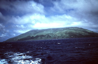
Fieldwork was conducted . . . 28 September-3 October, following reports of increased activity 1 August and the subsequent evacuation of the island's residents. Visits to the summit revealed weak fumarolic activity with sulfur deposition and boiling hot springs. A preliminary seismic study indicated very low levels of local activity, with no sign of a recent increase. A regional network of single vertical-component, short-period seismometers was installed, with instruments located on the islands of Pagan, Alamagan, and Anatahan, and a receiving station on Saipan. The residents evacuated in August had not returned to their homes as of early October.
Geological Summary. The highest of the Marianas arc volcanoes, Agrigan contains a 500-m-deep, flat-floored caldera. The elliptical island is 8 km long; its summit is the top of a massive 4000-m-high submarine volcano. Deep radial valleys dissect the flanks of the thickly vegetated stratovolcano. The elongated caldera is 1 x 2 km wide and is breached to the NW, from where a prominent lava flow extends to the coast and forms a lava delta. The caldera floor is surfaced by fresh-looking lava flows and also contains two cones that may have formed during the only historical eruption in 1917. This eruption deposited large blocks and 3 m of ash and lapilli on a village on the SE coast, prompting its evacuation.
Information Contacts: R. Koyanagi, HVO.