Report on Maug Islands (United States) — June 1992
Bulletin of the Global Volcanism Network, vol. 17, no. 6 (June 1992)
Managing Editor: Lindsay McClelland.
Maug Islands (United States) No activity evident
Please cite this report as:
Global Volcanism Program, 1992. Report on Maug Islands (United States) (McClelland, L., ed.). Bulletin of the Global Volcanism Network, 17:6. Smithsonian Institution. https://doi.org/10.5479/si.GVP.BGVN199206-284143
Maug Islands
United States
20.02°N, 145.22°E; summit elev. 227 m
All times are local (unless otherwise noted)
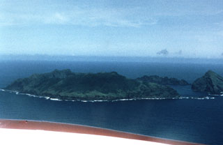
A six-member team of USGS volcanologists visited the Commonwealth of the Northern Mariana Islands 11-27 May 1992 at the request of the CNMI Office of Civil Defense. Aerial observations [of Maug] on 13 May revealed no signs of steaming or other evidence of recent volcanic activity.
Geological Summary. The three small elongated Maug Islands, the largest ~2.3 km long, represent the rim of a 2.5-km-wide caldera on a submarine edifice more than 20 km in diameter. The caldera has an average submarine depth of about 200 m and contains a central lava dome that rises to within about 20 m of the ocean surface. The truncated inner walls of the caldera on all three islands expose lava flows and pyroclastic deposits that are cut by radial dikes; bedded ash deposits overlie the outer flanks of the islands. No eruptions are known since the islands were documented by Espinosa in 1522 CE. The presence of poorly developed coral reefs and coral on the central lava dome suggests a long period of general quiescence, although it does not exclude mild eruptions (Corwin, 1971). A 2003 NOAA expedition detected possible evidence of submarine geothermal activity.
Information Contacts: R. Moore, USGS; R. Koyanagi, M. Sako, and F. Trusdell, HVO.