
Smithsonian Institution
Bulletin of the Global Volcanism Network, vol. 30, no. 8 (August 2005)
Managing Editor: Richard Wunderman
Langila (Papua New Guinea) Increased eruptive vigor leads to ashfall damage in mid-2005
Please cite this report as:
Global Volcanism Program, 2005. Report on Langila (Papua New Guinea) (Wunderman, R, ed.). Bulletin of the Global Volcanism Network, 30:8. Smithsonian Institution. https://doi.org/10.5479/si.GVP.BGVN200508-252010
The Darwin VAAC issued an activity report stating that the Rabaul Volcano Observatory (RVO) had noted elevated activity since 24 April 2005. Between 28 April 2005 and 4 May 2005 Langila emitted more ash than normal, and the International Federation of Red Cross And Red Crescent Societies (IFRC) determined that ~ 3,490 people had been affected by the eruption when ashfall damaged small food gardens and contaminated some water sources.
VAAC reports on 4 May and 6-7 May noted thin plumes extending NW 110 km and 75 km, respectively. Later, on 7-8 May, the identifiable plume was half as long and diminishing. Plumes and other diagnostics eventually became obscured by weather clouds. On 8 June analysts at the Darwin VAAC saw a low-altitude plume and a hot spot. The plume moved westward and remained visible into 9 June when it ceased being detectible.
During 13-19 June 2005, Langila's Crater 2 continued to erupt. At times the eruption was marked by moderate to strong emissions of thick gray-brown ash clouds occurring at irregular intervals. Ash clouds from the eruption rose variably to 700-1000 m before they were blown to the W and NW. At other times weak to moderate emissions of light gray ash clouds were observed. Considerable ash fell near the volcano and extended to the W and NW, between Warimo and Aimola. Crater 3 was quiet. Low and high frequency earthquakes and volcanic tremor were recorded.
The Darwin VAAC reported a Langila plume on 13 June to 3-4 km altitude, but cloud cover later obscured the plume. Another plume became visible on imagery on 16 June moving W at 30 km/hour at an estimated altitude of ~ 3 km; ongoing plumes became hard to see about mid-day on 17 June. Several other episodes of plume image detection were seen. One was identified by the VAAC on 21 June, with an observation of altitude to ~ 3 km and plume length reaching 300 km to the NW. The evidence of eruption only continued until the next day, when cloud cover obscured the area. A further, brief episode of plume detection occurred beginning early on 25 June but detection ended before noon. On 30 June, the Darwin VAAC repeated a US Air Force Weather Agency (AFWA) report on a Langila plume seen on imagery, blowing SW at 20 km/hr and reaching ~ 3 km altitude. By about 6 hours later that plume ceased to be visible.
Moderate levels of volcanic activity occurred at Langila's Crater 2 during 15-21 August. The activity was marked by occasional sub-continuous forceful emissions of ash clouds. The ash clouds rose as high as 1 km before drifting N and NW. Fine ash fell in villages along the coast. On the evening of 18 August projections of incandescent lava fragments were seen. Based on a pilot report, the Darwin VAAC reported that ash from Langila was visible in the vicinity of the volcano on 23 August, at 3-4.6 km altitude. A plume was seen a bit later on MODIS imagery extending 110 km to the NNW but ash was not visible in satellite imagery.
Information Contacts: Rabaul Volcano Observatory (RVO), P.O. Box 386, Rabaul, Papua New Guinea; International Federation of Red Cross And Red Crescent Societies (IFRC) (URL: https://reliefweb.int/); U.S. Air Force Weather Agency (AFWA)/XOGM, Offutt Air Force Base, NE 68113, USA; Darwin Volcanic Ash Advisory Centre (VAAC), Bureau of Meteorology, Northern Territory Regional Office, PO Box 40050, Casuarina, Northern Territory 0811, Australia (URL: http://www.bom.gov.au/info/vaac/).
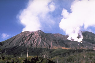
Geological Summary. Langila, one of the most active volcanoes of New Britain, consists of a group of four small overlapping composite basaltic-andesitic cones on the lower E flank of the extinct Talawe volcano in the Cape Gloucester area of NW New Britain. A rectangular, 2.5-km-long crater is breached widely to the SE; Langila was constructed NE of the breached crater of Talawe. An extensive lava field reaches the coast on the N and NE sides of Langila. Frequent mild-to-moderate explosive eruptions, sometimes accompanied by lava flows, have been recorded since the 19th century from three active craters at the summit. The youngest and smallest crater (no. 3 crater) was formed in 1960 and has a diameter of 150 m.


 Langila