
Smithsonian Institution
Natural Science Event Bulletin, vol. 2, no. 3 (March 1977)
Managing Editor: David Squires
Ukinrek Maars (United States) Explosions send ash plume above 6 km height
Please cite this report as:
Global Volcanism Program, 1977. Report on Ukinrek Maars (United States) (Squires, D, ed.). Natural Science Event Bulletin, 2:3. Smithsonian Institution. https://doi.org/10.5479/si.GVP.NSEB197703-312131
On 30 March, explosions were reported at 1500 and 1720 from a vent 13 km [but see 2:4] NW of Peulik volcano. The latter explosion was viewed from close range from a Wien Air Alaska plane. Its crew reported that the dense, ash-laden eruption cloud rose higher than 6,000 m. Peulik, an 1,844-m stratovolcano with a dacite lava dome, last erupted in 1852. It is surrounded by several small olivine andesite scoria cones.
Information Contacts: T. Miller, USGS, Anchorage.
Geological Summary. Ukinrek Maars are two explosion craters that were created in an area without previous volcanic activity during a 10-day phreatomagmatic eruption March-April 1977. The basaltic maars were erupted through glacial deposits in the Bering Sea lowlands 1.5 km S of Becharof Lake and 12 km W of Peulik volcano; their location is related to the regional Bruin Bay fault. The elliptical West Maar, which was the first to form, is 105 x 170 m and 35 m deep. The other maar, 600 m to the east, is 300 m wide and 70 m deep. Both maars are now filled by crater lakes; the eastern lake encircles a 49-m-high lava dome that was emplaced at the end of the eruption. Base surges were directed primarily to the NW. Juvenile material from the Ukinrek eruptions was of mantle-derived olivine basaltic composition. The dacitic Gas Rocks lava domes, of Quaternary age, are located on the shores of Becharof Lake, 3 km N of Ukinrek maars and were the site of a phreatic eruption about 2,300 years ago.


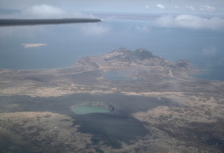 Ukinrek Maars